
|
Geological Survey Bulletin 611
Guidebook of the Western United States: Part A |
ITINERARY
|
|
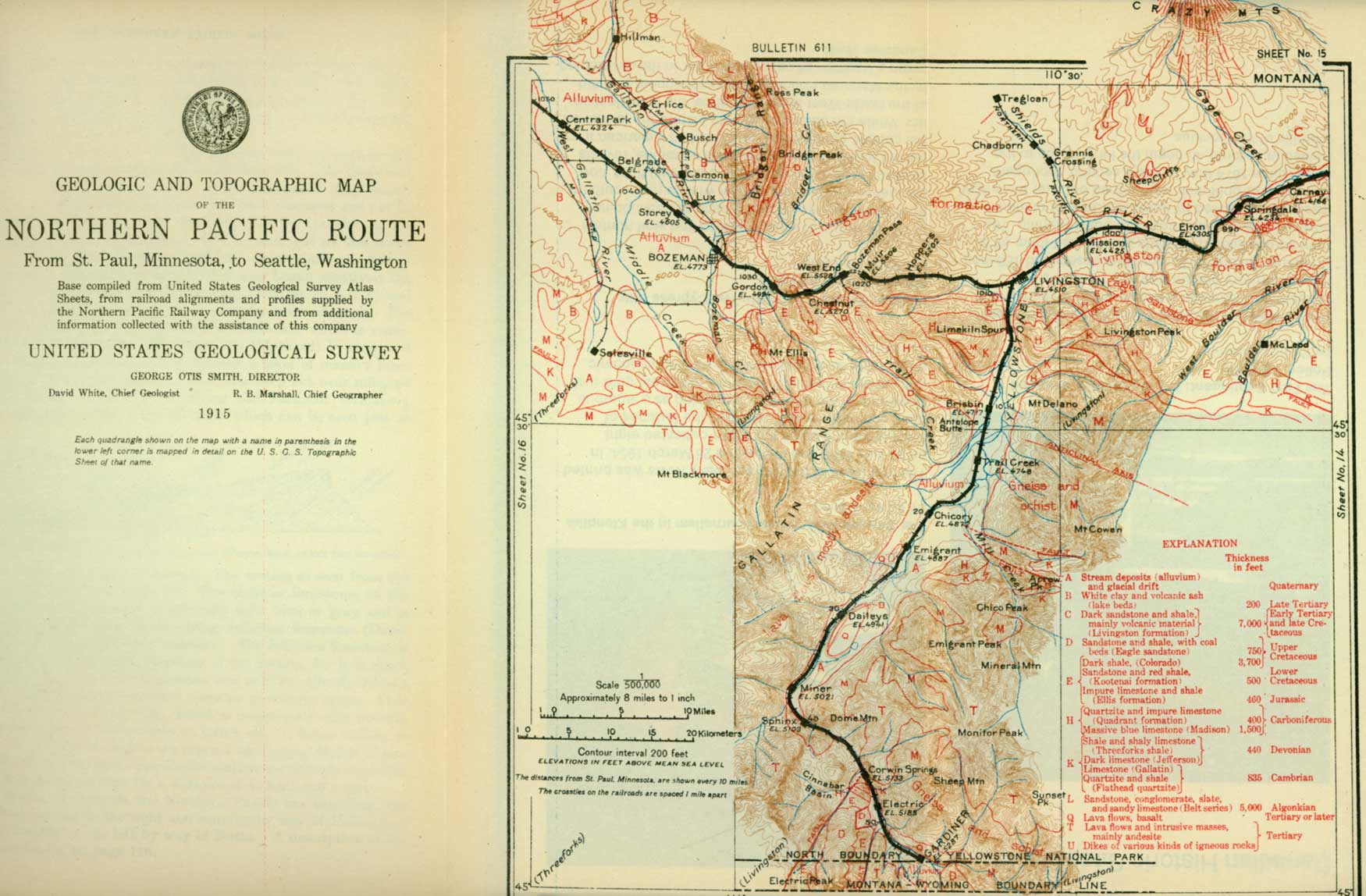
SHEET No. 15. (click on image for an enlargement in a new window) |
|
Springdale. Elevation 4,234 feet. St. Paul 989 miles. |
Springdale (see sheet 15, p. 98) is the stopping place for those going to Hunters Hot Springs, which are visible on the right at a distance of about 1-1/2 miles. These springs are reported to have been well known to the Indians before the advent of the white man. They were discovered in 1864 by Dr. J. A. Hunter, who, with his family, was on his way to the newly discovered gold fields of Montana. The springs discharge 90,000 gallons of water an hour at a temperature of 148° to 168° F.
Beyond Springdale the river passes through a narrow gorge known as McAdows Canyon. In this canyon the rocks, which are well exposed, show many wrinkles or minor folds that were undoubtedly formed by the upheaval of the great Absaroka Range, on the south. The mountain range is high and rugged, indicating a youthful stage in its development, for if the range were old it would have been worn down by erosion and its rugged features would have been smoothed and rounded off. Another proof that the Absaroka Range has been recently formed is found in the fact that the rocks along its flanks have been wrinkled and upturned by the same forces as those that folded and raised the mountain rocks into their present positions. From this it is evident that the mountains must have been formed since the deposition of the youngest of the plains rocks, and as the Fort Union formation, which is early Tertiary, is involved in the folding, the mountains must have been formed in middle or late Tertiary time.
On the right (north) near milepost 103 a near-by view may be obtained of the Sheep Cliffs, which, as seen from the train, are very prominent. They are the result of an intrusion of molten lava between beds of sedimentary rocks, probably from some of the dikes connected with the core of the Crazy Mountains. When this sheet of igneous material was forced in between the beds they were in all probability deep in the earth, but the cutting of the streams has revealed the igneous rock, and owing to its superior hardness it stands up almost like a mountain.
West of milepost 105 a glimpse can be obtained on the right, ahead, of the highest part of the Bridger Range, which, though small, has a very sharp crest and which separates the valley of the Yellowstone from the headwaters of Missouri River on the west. The structure and character of this range are illustrated by figure 17 (p. 98).
At Mission station a branch leaves the main line and after crossing Yellowstone River follows up Shields River, so named by Capt. Clark for a member of his party. This valley has the reputation of producing some of the finest oats grown in the State.
Just before the train enters Livingston it crosses Yellowstone River for the last time on the main line. Here the Yellowstone is a clear, rushing mountain stream, very different from the turbid river farther east. The traveler now comes face to face with the great mountain wall that forms the north front of the Absarokas and can look up at the commanding heights, which tower nearly a mile above him and which during much of the year are covered with snow.
|
Livingston. Elevation 4,510 feet. Population 5,359. St. Paul 1,008 miles. |
Livingston, originally called Clarks City, was named in honor of Charles Livingston, of New York, one of the directors of the Northern Pacific Railway. The main line of the road was finished to this place on January 15, 1883, and the branch line to Yellowstone Park, which now carries many thousands of tourists annually, began operation in August of the same year. Livingston is a division terminal and essentially a railway town.
[The description of the route west of Livingston begins on page 94.]
LIVINGSTON TO GARDINER (YELLOWSTONE NATIONAL PARK).
The train for Yellowstone Park, on leaving Livingston, turns to the left (south) and heads directly for the mountains, through a wide bottom which, though composed largely of gravel brought down by the river, is mostly under a high state of cultivation. For some distance the rocks are not well exposed, as the railway is built on alluvial material (material laid down by running water) and the rocks can be seen only in the cut edge of a low terrace on the right (west). The formations are upturned against the mountains at an angle of about 20°, and as the railway runs at right angles to their upturned edges the train passes them in quick succession.
The main outer range which forms the gateway though which the train enters the mountains is composed of very old (Paleozoic) rocks, chiefly limestone, shale, and quartzite.1
1The smooth slopes of the terrace on the west are composed of the Eagle sandstone, which is not well exposed and probably not recognizable from the train, and the underlying dark shale of the Colorado, which is well exposed south of Billings. The relation of the various beds can be better understood by consulting figure 13, which shows the rocks as the traveler sees them on the right. Opposite milepost 3 are sandstone and red shale, which underlie the dark shale of the Colorado. These beds constitute one of the most resistant formations of the plains and on the east side of the river they make a hoghack ridge which is a fine example of its kind. This formation was at one time regarded as the Dakota sandstone, but is now known to be the Kootenai, of Lower Cretaceous age. It is the same formation as that carrying the coal beds at Sand Coulee and Belt, southeast of Great Falls, but in the vicinity of Livingston no coal has yet been found in it. Below the Kootenai there are shale and limestone containing fossil sea shells of Jurassic age.
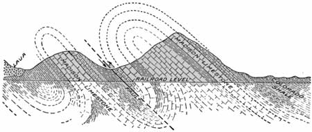
FIGURE 13.—Cross section showing the rim of the mountains south of Livingston, Mont. The rocks were crowded together until they bent into great folds, which later broke, resulting in overthrust faults. The next formation to attract attention consists of a great mass of limestone, which makes the mountain front and which is one of the most conspicuous sedimentary formations in the Rocky Mountain region. It will be seen many times on the trip and the traveler will doubtless learn to recognize it wherever seen. This thick-bedded formation is of early Carboniferous age and is known as the Madison limestone. It makes the front of the mountain on the east side of the river as far as the eye can see and on the west side for a distance of 7 or 8 miles. Its base can be seen about 4-3/4 miles south of Livingston, or just opposite the county bridge across the river. Beneath the Madison is a great mass of shale, limestone, and quartzite embracing formations of Devonian, Silurian, and Cambrian age, but as these various formations can not be distinguished from the train they will not be described in detail. Some of these are very old rocks, even older than the St. Peter sandstone, which was seen at St. Paul.
|
Brisbin. Elevation, 4,7l7 feet. St. Paul 1,018 miles. |
The great mountain mass beyond this outer range is
anticlinal in structure; that is, it once formed an immense arch. The top
of the arch is eroded and the traveler can not see the formations rising
on one side of the fold, curving over the top, and descending on the
other side, but they once formed such an arch, and the flanks and core
of it still remain to tell the story to the geologist. There are on the
flanks of the large fold a number of small folds, and the rocks that
have just been described constitute such a wrinkle. This minor fold, as
shown in the section (fig. 13), has been pushed over toward the south
beyond the vertical, so that the beds on the south side dip toward the
anticline instead of away from it, as they would had they not been
overturned. This fold is bounded on the south by a fault (a break in the
rocks), and near Brisbin it is succeeded by a smaller fold of the same
type. The Madison limestone making the core of this smaller fold forms
the high, straight ridge or spur that
trends at right angles to the
railway. Beyond this ridge there are traces of another kind of
fold—a trough or syncline which lies at the base of the limestone
ridge and extends far to the northwest where it contains the Trail Creek
coal field. Coal is being mined from Cretaceous rocks in this syncline
at the present time, but the product of the mines reaches the railway on
the other side of Bozeman Pass.
Beyond Brisbin the rocks on the west forming the Gallatin Range are made up of volcanic materials, some of which consist of fine fragment (tuffs) blown out of some crater with explosive violence or of coarse angular blocks derived from the same source or from the breaking up of partly cooled lava flows.
The rocks on the east side of the valley from Deep Creek, opposite Brisbin, on the north to Mill Creek on the south are very ancient gneiss and schist. This great mass of crystalline rock constitutes the central part of the large anticline already described, from which all the younger sedimentary formations have been removed by erosion. Traces of the sandstones and limestones that once constituted the south flank of the fold are to be found up Mill Creek, but they are so badly faulted and covered with volcanic breccia (rock composed of angular fragments) that they can not be easily recognized from the train. The most prominent peak in this part of the valley is Mount Cowen, which has an altitude of 11,190 feet and stands 6,400 feet above the bottom of the valley.
|
Chicory. Elevation 4,872 feet. St. Paul 1,028 miles. |
As far as milepost 16 the railway is on the flat surface of a terrace 50 to 75 feet above river level. This was formed by the glaciers that, long ago, came down Yellowstone and Mill Creek valleys and joined near the village of Chicory. The streams flowing from the melting ice carried large quantities of gravel and sand and dropped them in the open valley, filling it to a considerable depth. Since the ice melted away the river has cut a deep channel in this filling, leaving remnants of it here and there in the form of terraces. As the terrace was built only below the limit of the glacier, the railway is forced, opposite the mouth of Mill Creek, to leave the terrace and descend to the valley bottom on which lay the great mass of ice.
|
Emigrant. Elevation 4,887 feet. St. Paul 1,031 miles. |
In the vicinity of Emigrant there is a thin sheet of basalt (a dark massive volcanic rock) capping the terrace on the right. This rock exhibits the vertical columnar structure common to such material, and it is probable that the several masses of basalt which can be seen up the canyon are parts of one lava flow that originated somewhere in the park and extended down the valley as far as this place. It can be followed on the right for 3 miles, but beyond that it has been eroded for some distance, leaving no trace of its presence.
|
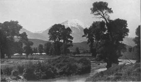
| PLATE XIV.—EMIGRANT PEAK, THE SENTINEL GUARDING THE NORTHERN APPROACH TO YELLOWSTONE PARK. View from Chicory, Mont. Elevation of peak 10,969 feet. Height above the railway 6,100 feet. Photograph by Haynes, St. Paul, Minn. |
|
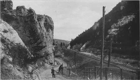
| PLATE XV.—ROCKY GATEWAY WHICH ROCK CREEK HAS CUT THROUGH THE MADISON LIMESTONE BELOW CHESTNUT, MONT., LOOKING EAST. Photograph by Schlecton, Bozeman, Mont. |
In the vicinity of Emigrant the most prominent topographic feature is Emigrant Peak (Pl. XIV), which dominates the entire valley. From the train this appears to be an isolated mountain, but the map shows that it is merely a prominent spur projecting from the mountain mass. The peak has an altitude of 10,960 feet, and its summit stands 6,000 feet above the valley. The base of the peak is composed of old gneiss, a rock which the traveler will have a good chance to see at close range farther up the canyon, and its summit of the andesitic breccia and lava flows that at one time probably almost engulfed the range on the east and completely submerged that on the west. At milepost 24 the high, sharp summits of the Gallatin Range show on the right (west), but they are neither so rugged nor so imposing as the peaks on the east.
The sheet of basalt capping the terrace on the right in the vicinity of Emigrant disappears for a mile or more, but opposite milepost 28 it reappears on the other side of the river, capping a finely developed terrace at a height of about 150 feet above the river.
|
Daileys. Elevation 4,941 feet. St. Paul 1,039 miles. |
At Daileys, a little farther on, a complete section of the rocks forming the terrace can be seen, and these rocks record an entirely new chapter in the geologic history of this region. They consist of white marl and conglomerate overlain by dark gravel and the whole covered with the sheet of basalt that was poured out upon the surface as molten lava. The white materials are known, from their composition and the fossils they contain, to have been deposited in a lake or lakes in Miocene or Pliocene time. A brief description of these lake beds is given on page 113.
The sheet of basalt capping the terrace can be followed as far as milepost 33, but from that point nearly to the entrance to the park the terrace and the basalt are not present. At Point of Rocks, only a short distance farther on, the traveler can obtain a good idea of the kind of material composing a volcanic breccia, for the railway cuts through a projecting point of the breccia and it can be seen at close range. Here it is tinted a deep, rich red, which adds a warmth and beauty to the otherwise somber mountain slope.
|
Miner. Elevation 5,021 feet. St. Paul 1,045 miles. |
At Miner the river valley makes an abrupt bend to the southeast and the rocks on the right show clearly the smoothing action of the glacier that once passed over them. Each projecting mass of rock has been rounded and smoothed, especially on the side, which the upriver glacier struck first in its course down the valley.
A short distance above Miner the stream passes through a narrow rugged canyon, the walls of which are composed of gneiss and show clearly the intricate folds into which this rock has been bent and the character of the different layers composing it. Through most of this canyon the tracks are on the very brink of the river channel, and the traveler can look down on the left into the boiling flood which dashes and foams about the bowlders that have fallen into it from the rocky slopes above. The grade through this canyon is very steep, but the gorge is short and the slope of the valley beyond is more gentle.
|
Corwin Springs. Elevation 5,133 feet. St. Paul 1,055 miles. |
At Corwin Springs is a hotel for the accommodation of those who wish to use the hot waters. Above this place Cinnabar Mountain, on the west, is the most conspicuous object, but the wonderful structure of the mountain and its peculiar appearance can not be fully appreciated until the traveler reaches Electric. Cinnabar Mountain was named in the early days, when the bright-red streak that marks it from top to bottom was supposed to be due to the mineral cinnabar, a red ore of mercury. It is now known that this red streak, called the Devil's Slide, is a bed of shale and that there is no cinnabar in the mountain. Almost the entire geologic column of this part of Montana is here exposed, and the rocks are turned up on edge so that they can be studied without the exertion of making a difficult climb. The oldest rocks are seen first, as one ascends the valley, and then others come in orderly succession, ranging from Cambrian to Upper Cretaceous.1
1The geologic section exposed at Electric, if placed in its correct position, would be as follows:
Feet. Montana formation (Upper Cretaceous) 955 Colorado shale (Upper Cretaceous) 2,775 Kootenai formation (Lower Cretaceous) 577 Morrison formation (Jurassic or Cretaceous 185 Ellis formation (Jurassic) 277 Quadrant formation (Carboniferous) 200 Madison limestone (Carboniferous) 1,500 Threeforks shale (Devonian) 240 Jefferson limestone (Devonian) 200 Cambrian 700
7,609
|
Electric. Elevation 5,185 feet. St. Paul 1,057 miles. |
The town of Electric was established and extensive coal mines were opened at this place a number of years ago by the Montana Coal & Coke Co. Some of the mines were opened directly back of the town and some near the town but on the other side of the mountain, and the coal was brought to the tipple by an aerial tramway.
The coal is of excellent quality, apparently having been improved by the heat of igneous intrusions or by the intense pressures developed when the rocks were thrown into the great folds that are so apparent to-day, but the cost and difficulties of mining caused the undertaking to be abandoned.1
1The coal beds in this field are probably the same as those mined in the Trail Creek field and at Bridger, near Red Lodge, and formerly mined extensively at Cokedale, west of Livingston, but the coal of the Electric field is probably the best in Montana. The coal beds occur near the base of the Montana formation, probably in the Eagle sandstone. The coal field consists of a great block of the earth's crust, containing not only the Cretaceous coal-bearing rocks but also all the older formations known in the region This block of strata extends from Cinnabar Mountain (Yellowstone River) on the north to Electric Peak on the south, but in the south end the formation is so altered by dikes and sills of igneous rocks as to be scarcely identifiable. As shown by the map (sheet 15) and the section (fig. 14), the rocks are nearly flat in the southern part of the block, but are sharply upturned at the north end, forming Cinnabar Mountain. The great block of strata constituting the coal field is bounded on all sides by faults, and within this block another and small block has been broken from the larger mass and dropped about 1,000 feet. The smaller block contains the coal mine directly back of the town of Electric. Practically all the coal mined in this field was coked, the market being chiefly the smelters at Butte and Anaconda. The heating value of the coal is 12,270 British thermal units.
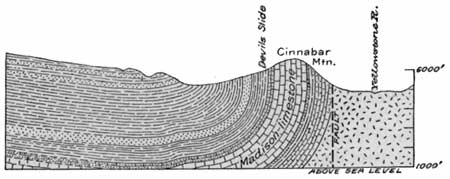
FIGURE 14.—Diagram showing the structure of Cinnabar Mountain, Mont.
At Electric station Electric Peak (elevation 11,000 feet), one of the highest mountains in the vicinity, may be seen on the right. The peak was so named because of a severe electric storm during its ascent by members of the Hayden Survey in 1872. One of the men was severely shocked, and all the others experienced prickly sensations as if they were receiving the discharge from an electric machine. The station and coal field took their names from the mountain.
Above Electric bowlders of dark basalt and the outcropping edge of a sheet of similar material on the far side of the river indicate that a stream of basaltic lava once flowed down the river valley at least as far as Emigrant. Since it solidified the river has cut most of it away, leaving the two or three remnants noted.
|
Gardiner. Elevation 5,287 feet. Population 346.* St. Paul 1,062 miles. |
At Gardiner the traveler has arrived at the northern entrance to Yellowstone Park. Descriptions of the park and the principal routes through it are given in other Government and private publications. The railroad route to Yellowstone, Mont., the western entrance to the park, is described in Survey Bulletin 612 (Guidebook of the western United States, Part B).
MAIN LINE WEST OF LIVINGSTON.
As the train leaves Livingston for the continuation of the westward journey, an excellent view can be obtained on the south of the entrance to the valley of the upper Yellowstone, sometimes called the "gate of the mountains." West of Livingston the railway crosses the northern point of the Gallatin Range at Bozeman Pass. This pass was discovered by Capt. Clark, who crossed the summit on his return journey July 15, 1806. He expressed surprise at the ease with which he passed from the Gallatin Valley on the west to that of the Yellowstone on the east. Although this is a low summit and an easy one to cross with a wagon or on foot, it offered a considerable obstacle to the railway, as it involved a climb from Livingston of 996 feet in 12.2 miles. Originally the railway followed the creek with an easy grade nearly to its head and then reached the summit by a very steep ascent, but a few years ago a new roadbed having a regular grade from Livingston to the summit at Muir was established.
The mountain side on the left (south) presents many interesting features, especially to one not familiar with mountains. Early in the summer light-green grassy slopes interspersed with patches of brush or groves of aspen extend part way up the mountain to the forest of evergreen trees that thrives upon the upper slopes. At the lower margin of the forest the trees appear singly or in groups, but higher up they cover the entire surface with their dense foliage. Here and there are the marks of old burns in which the tree trunks stand out as whitened skeletons that later fall headlong in a hopeless tangle and then are concealed by the second growth of trees. Late in the summer the lower slopes may be brown, but with the coming of the early frosts the woods are bright with color, the soft yellow of the aspens blending with the reds and browns of the scrub maple and the oak. The lower limit of the timber, which seems to be fairly definite, is not controlled directly by the altitude but by the greater precipitation on the mountain slopes than on the plains below them.
Along the new grade many exposures of the Livingston formation can be seen in the deep cuts. It consists of chocolate-colored shale and sandstone of a lighter shade but still showing a brownish tinge, which is due to the fragments of volcanic matter of which it is composed. The beds are somewhat wrinkled and disturbed but generally dip to the right, away from the mountain, at an angle of about 20°.1
1As the rocks dip away from the mountains, as shown in figure 13 (p. 89), lower formations than those exposed in the railway cuts appear toward the south. These lower rocks include the coal-bearing formation which crops out in a continuous band from Livingston across the summit to Chestnut. This formation overlies the Colorado shale and is about equivalent to the Eagle sandstone which is so prominent in the rim rock back of Billings. In most places the formation is only 100 feet thick, but about Livingston the sandstone with its accompanying shale beds is about 1,000 feet thick.
Formerly the Cokedale mine, one of the most productive in the State, was in operation about 7 miles west of Livingston and coke was manufactured from part of the coal, but the mine has been abandoned for a number of years and the railway spur leading to it has been removed.
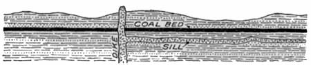
About half a mile beyond milepost 121, in a deep cut, two dikes of igneous rock are exposed cutting directly across the bedded sandstone and shale. In places where such dikes have cut through coal beds, or have taken the form of a sheet or sill below the coal, as illustrated in figure 15, the heat of the molten rock has changed the coal, the resultant material depending upon the conditions attending the intrusion. If air is present, the coal will burn out completely; if only a moderate amount of air is available, natural coke will be formed; and if little or no air is present, the coal will be baked into anthracite. Anthracite produced in this manner occurs in Colorado, New Mexico, and Washington.
|
| FIGURE 15.—Dike cutting coal bed and sill intruded in a position to affect the quality of the coal. |
|
Muir. Elevation 5,506 feet. St. Paul 1,020 miles. |
After a long climb the summit is reached at Muir, a station at the east end of the Bozeman tunnel, which has a length of 3,610 feet. The summit of the pass is only a few hundred feet above the level of the railway. Beyond the tunnel the Eagle sandstone, which was seen back of Billings and again obscurely at Livingston, carries coal beds which have been prospected and mined at various places west of Livingston. As a general rule the coal crops out along the base of the mountain on the south, and the remains of old mines can be seen on both sides of the track as far as Chestnut. The coal is of good quality, but on account of the heavy percentage of ash and the expense of mining, all of these operations have ceased. Just east of Chestnut, however, a branch line turns to the left up Meadow Creek and goes southeastward across the summit to the Trail Creek field, in which mining is still carried on.
|
Chestnut. Elevation 5,270 feet. Population 261.* St. Paul 1,024 miles. |
|
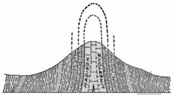
| FIGURE 16.—Vertical fold in Madison limestone west of Chestnut, Mont. |
About a mile beyond Chestnut the railway cuts through the point of a closely folded anticline in which the Madison limestone forms the core, as shown in figure 16. (See Pl. XV, p. 91.) The exposures are not good enough for the traveler to see all the formations that are involved in the fold, but after passing some coal beds he may see sandstone with red shale (Kootenai, Lower Cretaceous), and then on his right hand a broad band of the same red shale as that which produces the Devil's Slide at Electric. These rocks are standing vertical. Next comes the Madison limestone (Carboniferous), which is the oldest rock exposed. This massive limestone is dissolved and cut by the streams into curious towers and pinnacles, and by the exercise of his imagination the traveler may see resemblances to almost any form he desires. West of this maze of sculptured towers and crags the rocks that were seen on the east side of the fold are crossed in reverse order. This fold, although small in comparison with those that make up the mountains, may give the traveler some idea of the great forces which have crumpled the rocky crust of the earth like paper. No formation is massive enough to resist them.
|
Bozeman. Elevation 4,773 feet. Population 5,107. St. Paul 1,033 miles. |
At milepost 136 the train emerges from the narrow defile of Rocky Canyon and the traveler obtains his first view of the Gallatin Valley. On the left between mileposts 137 and 138 are a few old buildings that once constituted a part of Fort Ellis, an important military post during the Indian wars. This post was established by order of Gen. Terry in 1867 and abandoned in 1887. A little farther on the train arrives at Bozeman, one of the oldest and most prosperous agricultural towns in the State. Here in the heart of the Rocky Mountains, surrounded on all sides and protected by high ranges, is the Gallatin Valley, which is widely known on account of the fine farms it contains and the excellent and diversified crops it produces. The Montana State Agricultural College, situated at Bozeman, has assisted materially in the prosperity of the region by the introduction of scientific methods of farming and of handling the crops.
It seems rather strange that a part of the State so far removed from the regular westward routes of early travel and so walled in by the mountains should have been one of the first to be occupied by settlers. This was doubtless due to the description of the valley given by Capt. Clark, who discovered it in 1806. The first effort of the whites to obtain a foothold here was made by fur traders in the vicinity of Three Forks, on Missouri River, but that region, like Kentucky in the early days, was the common hunting and fighting ground of many Indian tribes, and the trading posts were soon swept away.
The first permanent settlement in the valley was made by John M. Bozeman, for whom the town was named, and a party of settlers whom he led into the valley in 1864. Another pioneer who entered the same year was James Bridger,1 one of the best-known guides, fur traders, and scouts of the Rocky Mountain region from 1830 to 1870. His visit here is perpetuated by the names Bridger Range, Bridger Peak, and Bridger Creek.
1Of all the men who renounced the conventionalities of civilization and cast their lot with the fur traders and trappers of the West, one of the most remarkable was James Bridger. He was well known to almost every western explorer and settler in the first half of the nineteenth century, but there are few written records of the man himself or of his many wanderings from Mexico on the south to the British possessions on the north. He was born in March, 1804. His father, who was a poor tavern keeper in Richmond, Va., moved to St. Louis in 1812, and so the boy grew up in the stirring atmosphere of romance and adventure of what was then the very edge of the great "Wild West." It is therefore of little wonder that at the age of 18 he joined a party under William Ashley to go to the mountains to hunt beaver for the Rocky Mountain Fur Co., which was organized in 1822 at St. Louis. By 1832 he had become a resident partner in this company and was generally recognized as a leader among the explorers and Indian traders of the time.
In the years from 1822 to 1870 Bridger roamed the country from Montana to Mexico and from the Rocky Mountains to the Pacific coast, but his headquarters were at a trading post built by him on the Black Fork of Green River, Wyo., generally known as Fort Bridger. It is said that he was the first white man to see Great Salt Lake (in the winter of 1824-25), but this statement has never been fully substantiated.
Unquestionably Bridger played a most important part in the exploration of the West, and his chief claim for recognition by posterity will rest upon this service. He was probably the best guide in this region and his services were sought by almost every leader of an exploring expedition in the Rocky Mountains. Capt. Gunnison says: "With a buffalo hide and a piece of charcoal he will map out any portion of this immense region and delineate mountains, streams, and circular valleys, called 'holes,' with wonderful accuracy." His name has been perpetuated in many of the natural features of the region, but the interesting personality of the man is largely lost in the hazy distance of a rapidly vanishing past.
Of James Bridger's last years little is known except that on losing his eyesight in 1870 he retired to a farm which he had previously purchased at Washington, Mo., about 5 miles east of Kansas City. Here the once eagle-eyed frontiersman lived in almost total blindness until his death July 17, 1881. Some years ago his body was rescued from an unnamed grave and a marble shaft was erected over his last resting place.
Recently an effort has been made to apply the name Sacajawea Peak to one of the peaks in the Bridger Range, in honor of the Indian woman who accompanied Lewis and Clark in their journey to the Pacific coast and return and who guided Clark through the Bozeman Pass.
|
Belgrade. Elevation 4,467 feet. Population 561. St. Paul 1,042 miles. |
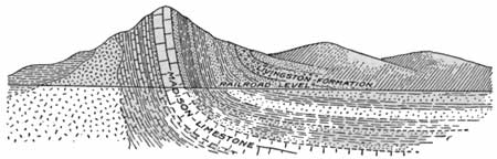
The Bridger Range, which is a conspicuous feature from the vicinity of Belgrade, consists of the upturned edges (see fig. 17) of the rocks of the Great Plains and so is really the Front Range of the Rocky Mountains. On its east side are the Cretaceous and Jurassic formations that were seen above Livingston, and the crest of the range is made up of the massive and resistant Madison and associated limestones of Paleozoic age. On the western slope gneiss similar to that seen on the road to Gardiner and argillite (hard shale) and sandstone of the Belt series are exposed, but within a short distance these rocks are buried beneath the soft clay and sand of the Tertiary lake beds. The Gallatin Valley, like that of the Yellowstone and also other intermountain valleys of Montana, at one time in the past was occupied by a lake. Into this lake were washed clay, sand, and gravel from the surrounding uplands and volcanic ash blown out from the craters of active volcanoes in the vicinity. The ash had the appearance of white dust, being composed of fine particles of glassy lava. On account of the abundance of volcanic ash the sediments deposited in this lake have a light color, which is readily recognized even at a distance of several miles.
|
| FIGURE 17.—Upturned Madison limestone and associated rocks, forming the Bridger Range, Mont., looking north. |
| <<< Previous | <<< Contents >>> | Next >>> |
bul/611/sec16.htm
Last Updated: 28-Mar-2006