|
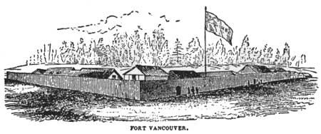
FORT VANCOUVER
The History of Fort Vancouver and its Physical Structure |

|
TABLE OF CONTENTS
SECTION I
HISTORICAL BACKGROUND
Chapter I. THE FOUNDING OF FORT VANCOUVER
Location
Historical Significance of Fort Vancouver
Historical Background
Development of the Fur Trade in New Caledonia and the Columbia River Basin
The North West Company on the Columbia, 1813-1821
North West Company vs. Hudson's Bay Company
Reasons for Union
Union and Reorganization
The License of Exclusive Trade
Preparations to Abandon the Columbia Department
Decision to Remain on the Columbia
Administrative Changes on the Columbia, 1821-1824
Plans to Move North of the Columbia: Origin of Fort Vancouver
Governor Simpson Plans to Visit the Columbia
Preparations for Simpson's Journey: Dr. John McLoughlin Appointed to the Columbia District
John McLoughlin
Simpson's Journey to Fort George
Description of the Columbia Department, 1825
Reorganization of the Columbia Department, 1824-1825
Reasons for the Abandonment of Fort George
Search for a New Site
Description of the Site of the New Depot
Reasons for Locating the New Headquarters Away from the River
Chapter II. OLD FORT VANCOUVER, 1824-1829
The First Buildings
Description of the New Post
Dedication and Naming of Fort Vancouver
McLoughlin: Supreme Ruler of the Columbia
Abandonment of Fort George
Continued Construction at Fort Vancouver
The Fort Vancouver Farm, 1824-1829: Field Crops
The Fort Vancouver Farm, 1824-1829: Fruit
The Fort Vancouver Farm, 1824-1829: Livestock
Western Headquarters and Depot
Development of the Columbia Department, 1825-1829
The Coastal Trade
Founding of Fort Langley, 1827
Development of Industries at Fort Vancouver, 1825-1829
Visitors to Fort Vancouver, 1825-1829
Governor Simpson's Second Visit, 1828-1829
Fort Vancouver Becomes the Permanent Departmental Depot
Fort Vancouver is Moved to New Location
Chapter III. HISTORY OF FORT VANCOUVER, 1829-1846: A BRIEF OUTLINE
The Coastal Trade
The Shipping
The Interior Fur Trade
Outposts in California and Hawaii
The Puget's Sound Agricultural Company
Advent of the Protestant Missionaries
Settlement of the Willamette Valley
Effect of Population Increase upon Fort Vancouver, 1840-1846
Troubles with Squatters
Administration of the Columbia Department, 1838-1841
Dispute Between McLoughlin and Simpson
McLoughlin Removed as Superintendent of Columbia Department
Resignation of McLoughlin
Removal of Depot to Fort Victoria
The Oregon Treaty of 1846
Chapter IV. HISTORY OF FORT VANCOUVER, 1846-1869: A BRIEF OUTLINE
Fort Vancouver Continues as a Subsidiary Depot
Removal of the Departmental Headquarters to Victoria
The Oregon Department, 1853-1860
Managers of Fort Vancouver, 1849-1860
Fort Vancouver and the Indian Wars
Decline of the Fur Trade
The General Merchandising Trade
Disputes Over Land Claims
Condition of Fort Vancouver in 1860
Fort Vancouver Military Reservation
Relations Between the Hudson's Bay Company and the Army, 1850-60
Evacuation of Fort Vancouver by the Hudson's Bay Company
Diplomatic Action Concerning Fort Vancouver
End of the Company's Tenure at Vancouver
Hudson's Bay Company Claims, 1846-1869
SECTION II
HISTORY AND DESCRIPTION OF THE PHYSICAL STRUCTURE
Chapter V. FORT VANCOUVER: THE PHYSICAL STRUCTURE
General View
Area Enclosed by the Stockade
Construction of the Stockade
Stockade Gates
Fort Vancouver Bastion
Construction of the Bastion
Armament of the Bastion
General Survey of the Buildings Within the Stockade
Buildings Within the Stockade, 1829-1841
Buildings Within the Stockade, 1841
Additional Buildings, 1841-1845
Fort Vancouver, 1845
Buildings Within the Stockade, 1846-1847
Buildings Within the Stockade, 1847-1860
Disappearance of the Fort, 1860-1866
Construction of Buildings Within the Stockade
Sills and Foundations
Walls
Roofs
Exterior Finish
Interior Finish
Miscellaneous Details
Smaller Buildings
Courtyard
Descriptions of Individual Buildings
The Bachelors' Quarters
Manager's Residence
Kitchen to Manager's Residence
The "Old" Roman Catholic Church
The Parsonage or Priests' House
"Owyhee Church"
Powder Magazine
Warehouses and Company Trading Shop
Bakery
Blacksmith Shop
Granary
The "Old" Office
The "New" Office
Harness Shop
Beef Store
Indian Trade Shop
Iron Store
Root House
Wells
Chapter VI. BUILDINGS OUTSIDE THE STOCKADE
General View, 1846
At the Mill Plain
At the Sawmills
At the Flour Mills
On the Fort Plain, Dairy Plain, and Other Agricultural Lands in the Immediate Vicinity of Fort Vancouver
Immediately East of the Southeast Corner of the Stockade
On the Rising Ground North of the Fort, from East to West
Near the Wharf and Pond, Southwest of the Fort
In the Village, West and Southwest of the Fort
Location Unknown
On Lower Plain
On Sauvie Island
Descriptions of Individual Buildings
The Sawmills
The Gristmills
Dundas Folly
Mosquito Grotto
The New Catholic Church
New Priests' House or Rectory
New Schoolhouses
The Village
The Hospital
The Cooper's Shop
The Salmon House
The Wharf
The Boat Sheds
Index (omitted from the online edition)
Dedicated to the memory of
HERBERT EUGENE BOLTON
who took a keen interest in this study
ILLUSTRATIONS AND MAPS
| Frontispiece | Fort Vancouver, circa 1845. Watercolor by unknown artist,
in Coe Collection of Western Americana, Yale University. From transparency in possession of First Federal Savings & Loan Association of Vancouver. |
| Plate I. | Ground Plan of Fort George, 1818. From Quarterly of the Oregon Historical Society, XIX (December, 1918), opposite p. 271. |
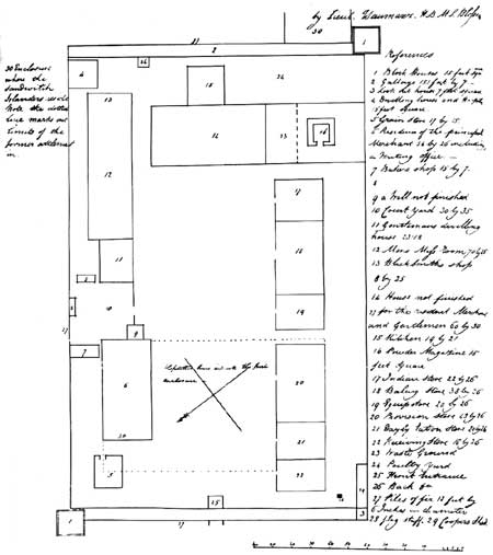
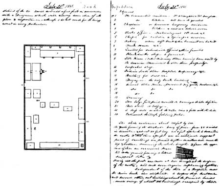
| Plate II. | Ground Plan of Fort Vancouver and Sketch of Palisade, 1841, from
Diary of George Foster Emmons. From George Foster Emmons, Manuscript Journals, MSS, in the Yale University Library. |
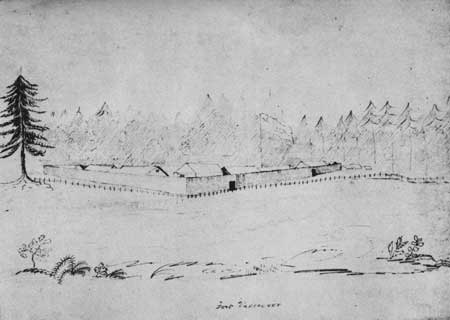
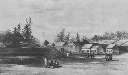
| Plate III. | View of Fort Vancouver from the Southwest, 1841, Drawn by Henry Eld. From Henry Eld, Journal, Statistics, &c., in Oregon and California, MSS, in Yale University Library. |
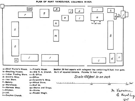
| Plate IV. | Ground Plan of Fort Vancouver, 1845, Based upon Map Drawn by M. Vavasour. From Quarterly of the Oregon Historical Society, X (March, 1909), opposite p. 100. |
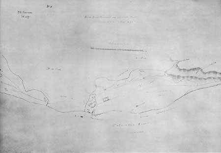
| Plate V. | Map of Fort Vancouver and Vicinity, Drawn by
M. Vavasour. Original in British Foreign Office. From photostat in possession of Howard J. Burnham. |
| Plate VI. | Fort Vancouver from the Southeast, 1845, Drawn by Henry J. Warre. From Warre, Sketches in North America and the Oregon Territory. |
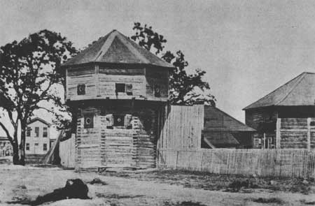
| Plate VII. | Bastion at Fort Victoria, Vancouver
Island, Showing Typical Construction of Octagonal Cap and Gun Ports. From The Beaver, Outfit 265, no. 2 (September, 1934), 48. |
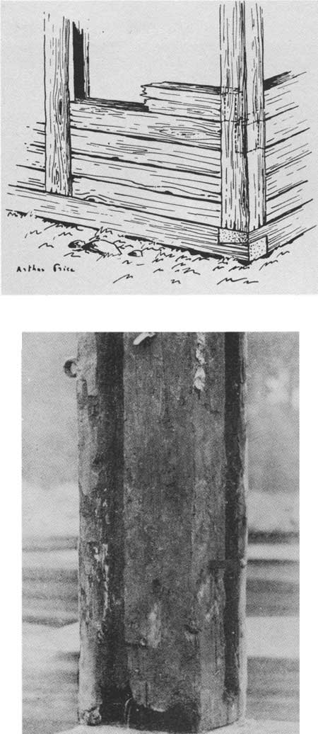
| Plate VIII. | 1. Diagram of Typical "Posts in the Sill" Construction, as Used at Fort Vancouver. From The Beaver, Outfit 276 (December, 1945), 10. 2. Corner Post, Fort Nisqually, Showing Grooved Upright. From The Beaver, Outfit 265, no. 2 (September, 1934), 52. |
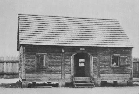
| Plate IX. | Granary, Fort Nisqually, Showing Typical H. B. C. "Posts in the Sill" Construction. From Photographic Records Office, The National Archives. |
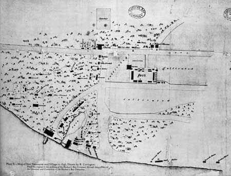
| Plate X. | Map of Fort Vancouver and Village in 1846, Drawn by R. Covington. From the original in the archives of the Hudson's Bay Company through the courtesy of the Governor and Committee of the Hudson's Bay Company. |
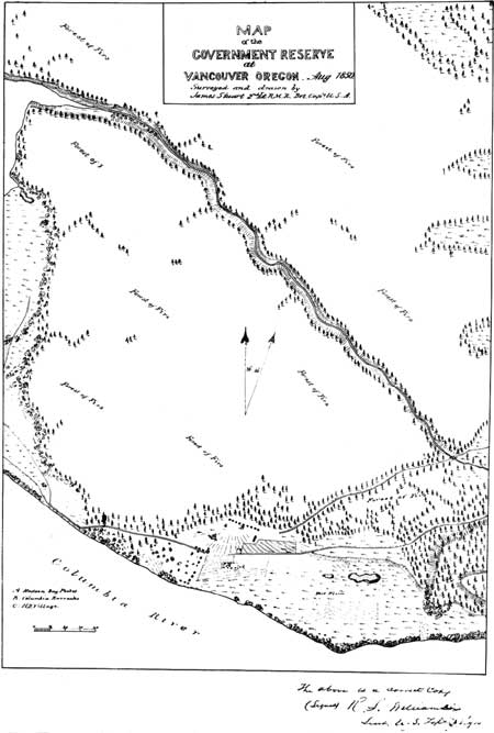
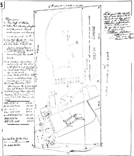
| Plate XI. | Map of the Government Reserve at Vancouver,
Oregon, August, 1850, Surveyed and Drawn by Brevet Capt. James Stuart. From General Land Office Records, Abandoned Military Reservation Series, Ft. Vancouver, Washington, Box 100, in the National Archives. |
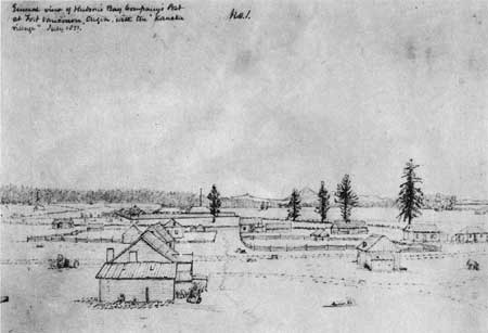
| Plate XII. | Fort Vancouver and the Village from the Northwest, July, 185 1, Drawn by George Gibbs. From collection of photographs entitled "Drawings by George Gibbs in the Far Northwest, 1849-1851," in the American Bureau of Ethnology. Smithsonian Institution. |
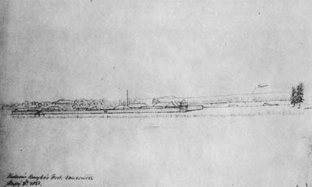
| Plate XIII. | Fort Vancouver from the North, July 2, 1851, Drawn by George Gibbs. From collection of photographs entitled "Drawings by George Gibbs in the Far Northwest, 1849-1851," in the American Bureau of Ethnology, Smithsonian Institution. |
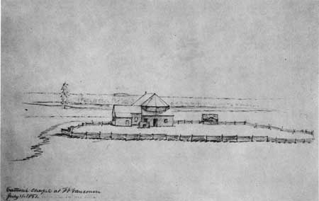
| Plate XIV. | Catholic Chapel at Fort Vancouver, July 1, 1851, Drawn by George Gibbs. From collection of photographs entitled "Drawings by George Gibbs in the Far Northwest, 1849-1851," in the American Bureau of Ethnology, Smithsonian Institution. |
| Plate XV. | Original Plan of Survey of Fort Vancouver Military
Reservation, Made in 1854 by Lieut. Col. B. L. E. Bonneville. From photostat in possession of Howard J. Burnham. |
| Plate XVI. | Map of the Government Reserve at Fort Vancouver Drawn by
Brevet Capt. T. R. McConnell in 1854 from the Survey Made by Lieut. Col. B. L. E.
Bonneville in 1854. From General Land Office Records, Abandoned Military Reservation Series, Ft. Vancouver, Washington, Box 100, in the National Archives. |
| Plate XVII. | Ground Plan of Fort Vancouver Military Reservation, 1854, by Joseph K. Mansfield. From Mansfield, Report . . . to Brevet Lieut. Genl. Winfield Scott, March 1, 1855, MS, in A. G. O., Miscellaneous File 282. |
| Plate XVIII. | Fort Vancouver from the Northwest, 1854, Drawn by Gustavus Sohon. From United States, War Department, Reports of Explorations and Surveys, to Ascertain the Most Practicable and Economical Route for a Railroad from the Mississippi River to the Pacific Ocean, vol. XII, plate XLIV. |
| Plate XIX. | View of Fort Vancouver from the Northwest, 1855, Drawn by R. Covington. From photostat in possession of Howard J. Burnham. |
| Plate XX. | Topographical Sketch of Fort Vancouver and Environs, 1855. From photostat in possession of Howard J. Burnham. |
| Plate XXI. | Plan of Fort Vancouver and Vicinity, 1859. Section of Map of the Military Reservation at Fort Vancouver, W. T., Surveyed under the Direction of Capt. Geo. Thom, Topographical Engrs. by Lieuts. J. B. Wheeler & J. Dixon . . . by Order of Brig. Gen. W. S. Harney, 1859, in General Land Office Records, Abandoned Military Reservation Series, Ft. Vancouver, Washington, Box 100, in the National Archives. |
| Plate XXII. | Northeast Corner of Courtyard, Fort Vancouver, May, 1860,
Showing the "Priests' House," the Manager's Residence, and the
Bachelors' Quarters. Photograph No. 3 filed by the United States, in British and American Joint Commission, Records, MSS, in General Records Division, State Department, in the National Archives. |
| Plate XXIII. | Northwest Stockade Corner, Fort Vancouver, May, 1860, Showing Store
house No. 2, the Trading Shop, the Blockhouse, the Granary, and the
Office. Photograph No. 3-1/2 filed by the United States, in British and American Joint Commission, Records, MSS, in General Records Division, State Department, in the National Archives. |
| Plate XXIV. | Ground Plan of Fort Vancouver, June 15, 1860. From Proceedings of a Board of Officers, Which Convened at Fort Vancouver, W. T., June 15, 1860, MS, in A. G. O., Oregon Department, Document File, 212-S-1860, in War Records Division, the National Archives. |
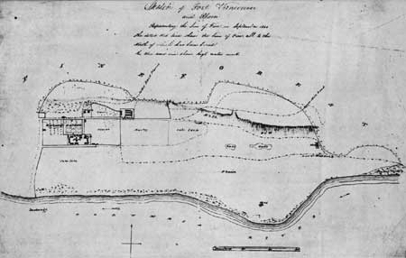
| Plate XXV. | Sketch of Fort Vancouver and Plain, Representing the Line of
Fire in September, 1844. From the original in the archives of the Hudson's Bay Company, through the courtesy of the Governor and Committee of the Hudson's Bay Company. |
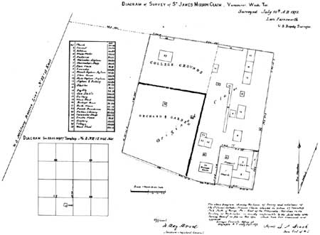
| Plate XXVI. | Diagram of Survey of St. James Mission Claim, 1872. From General Land Office Records, Old Townsites Series, Docket 1 (165), Box No. 31, in the National Archives. |
| Plate XXVII. | Map of Fort Vancouver and U. S. Military Post with Town, Environs, Etc.,
1859, Drawn by R. Covington. From the original in the archives of the Hudson's Bay Company, through the courtesy of the Governor and Committee of the Hudson's Bay Company. |
| Plate XXVIII. | Plat of the land around Fort Vancouver, showing Hudson's Bay Company's Claim, 1867. From British and American Joint Commission, Records, MSS, in General Records Division, State Department, in the National Archives. From photostat in possession of Howard J. Burnham. |
| Plate XXIX. | Summary Sheet, Archeological Excavations, Fort Vancouver National
Monument, Vancouver, Washington, 1954. From Louis R. Caywood, Final Report, Fort Vancouver Excavations. |
| Plates XXX, Plates XXXI, Plates XXXII, Plates XXXIII, Plates XXXIV, Plates XXXV, Plates XXXVI, Plates XXXVII, Plates XXXVIII. | Archeological Excavations, Fort Vancouver National Monument (9 sections). From Louis R. Caywood, Final Report, Fort Vancouver Excavations. |
| Plate XXXIX. | Hudson's Bay Company flag used at Fort Vancouver. In the possession of Fort Vancouver Restoration and Historical Society. |
| Plate XL. | 1. Southeast corner of stockade. 2. Uncovered foundation timbers of bastion, all badly burned except those on east wall. National Park Service photographs. |
| Plate XLI. | Trash pits provided a rich concentration of broken earthenware. National Park Service photograph. |
| Plate XLII. | Well-preserved stockade posts along south wall. National Park Service photograph. |
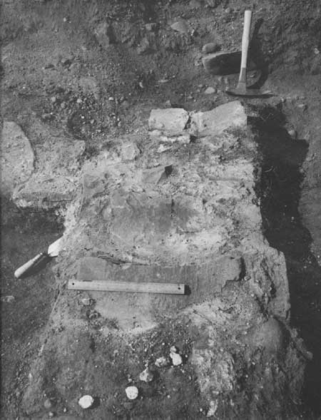
| Plate XLIII. | Northwest corner of powder magazine. National Park Service photograph. |
| Plate XLIV. | Intersection of west stockade wall and south wall of bastion. National Park Service photograph. |
| Plate XLV. | Chinese porcelain cup and plate. National Park Service photographs. |
| Plate XLVI. | 1. Copeland and Garrett "Late Spode." 2. Two large fragments of Copeland and Garrett blue and white platter. National Park Service photographs. |
| Plate XLVII. | 1. Blue underglaze semi-China bowls. 2. Green underglaze saucer bearing mark "Teniers Vignetres. H.M.I." National Park Service photographs. |
| Plate XLVIII. | Cosmetic jar lids. National Park Service photograph. |
| Plate XLIX. | 1. Jar originally containing shaving soap. 2. Clay pipes and stems. National Park Service photographs. |
| Plate L. | Brass door lock identical with those now on McLoughlin House, Oregon City, Oregon. National Park Service photographs. |
| Plate LI. | 1. Brass keys found during excavation of bastion. 2. a and b. Door plates. c. Large hinge from bastion. d. Offset hinge. e. Hasp. National Park Service photograph. |
| Plate LII. | 1. Broken blacksmith tools unearthed in southeast corner of stockade. 2. Broken scythe and handmade trowel with serrated handle. National Park Service photographs. |
| Plate LIII. | 1. Gun lock and powder pan of 1843 Springfield flintlock rifle. 2. Beaver trap parts. a. Trigger pan. b. Portion in which jaw rested when trap was set. c. and d. Broken springs, showing openings of two sizes. National Park Service photographs. |
| Plate LIV. | 1. Sheet metal funnel. 2. Iron object of unknown use. National Park Service photographs. |
| <<< Previous | <<< Contents>>> | Next >>> |
fova/hussey/contents.htm
Last Updated: 18-Feb-2008