|
John Jarvie of Brown's Park BLM Cultural Resources Series (Utah: No. 7) |

|
CHAPTER IV
SITE INVENTORY
The land upon which John Jarvie settled was never homesteaded. He merely chose a suitable spot along the Green River and squatted upon it. The property (Lot 3, Section 23, Township 2N, Range 24E) was not even granted to the State of Utah by the United States of America until 1907. In 1916 the State of Utah granted a patent to the Jarvie heirs and the land which their father had lived and died on legally became theirs. [219]
Tom Jarvie and John Jarvie, Jr. lived on the property off and on for several years; however, their major interests lay elsewhere and the property was generally neglected until 1924 when it was sold to Charles L. Sparks. Ten years later, following Charles's death, the Sparks heirs sold the property to Frank E. Jenkins. The Jenkins family resided on the ranch until 1942 making substantial changes to the site during their occupancy.
In 1942 local rancher William Allen purchased the property. Allen's wife, Marie Taylor Allen, was a descendant of an early Brown's Park family. Her father, Charlie Taylor, and older brother, Jess, had freighted for Jarvie in the early part of the century and were among the first to arrive at the ranch following the murder. Mrs. Allen was a respected local historian and helped to preserve much of Brown's Park's colorful history. In 1968 the Allens sold the ranch to Duward and Esther Campbell and moved a mile downstream to another ranch where Marie Allen is now buried.
|
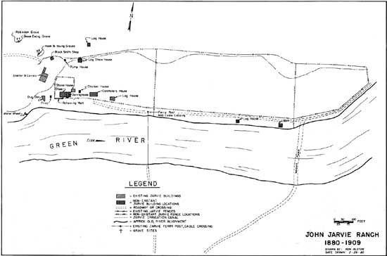
| Figure 1. John Jarvie Ranch, 1880-1909. (click on image for a PDF version) |
|
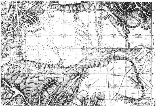
| Figure 2. June 10, 1899, General Land Office survey plat of Township 2 North, Range 24 East, Salt Lake Base and Meridian showing Jarvie Ranch in Section 23. (click on image for a PDF version) |
The Campbells had lived most of their lives in the Brown's Park area where Esther is well known as the "school marm" who taught in the area's one-room schoolhouses. Esther collected Brown's Park history and memorabilia (much of it from her good friend Ann Bassett) and turned the old stone house into a museum. Esther became a local "institution" and is much loved by hundreds of fishermen, campers, hunters, history buffs, and tourists who make yearly pilgrimages to the Jarvie Ranch. Following Duward's death, Esther was anxious to see the ranch preserved and restored to its historic character. Spurning lucrative offers from commercial developers, she sought out the Bureau of Land Management as a potential buyer.
Funding was not available for a timely purchase by the Bureau in 1977 when the property was first placed on the market. The Bureau contacted Nature Conservancy which agreed to assist in the acquisition. Consequently, in 1978, Mrs. Campbell sold the property to Nature Conservancy. In turn, Nature Conservancy leased the property to the Bureau. The Vernal District of the Bureau of Land Management has assumed management of the ranch and will purchase the property when funding is available.
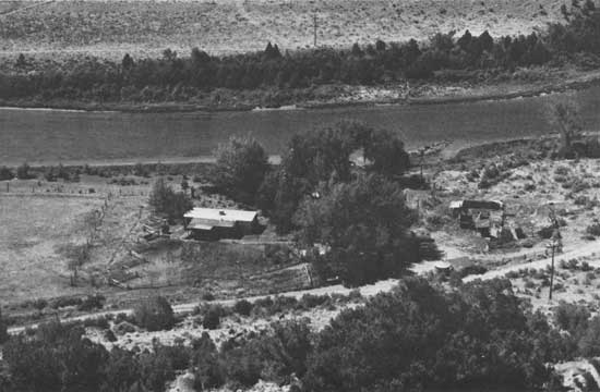
The 35.38 acres of land known as the Jarvie Ranch contain a wealth of structures, remnants, and sites of interest. These items fall into four major categories: existing Jarvie structures and objects, non-existing Jarvie structures and objects, existing post-Jarvie structures and objects, and non-existing post-Jarvie structures and objects.
First, there are many significant Jarvie era structures and objects on the property. The oldest of the historic buildings is the dugout on the southwestern end of the property where John and Nellie first lived in Brown's Park and where outlaws later gathered. It is built into a hillside with the south-facing entrance overlooking the Green River.
|
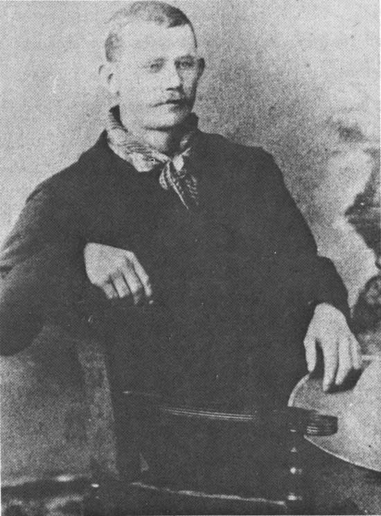
| Photo 31. Charlie Sparks, purchased the Jarvie property in 1924. (Photo Credit: Glade Ross Collection). |
|
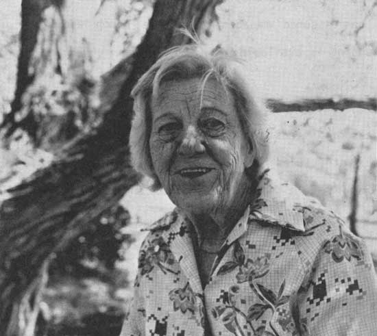
| Photo 32. Esther Campbell, owner of the Jarvie property from 1968 until 1978. (Photo Credit: Bureau of Land Management). |
The dugout is a two-room structure. A small 4' x 3' entry leads to the front (south) room which measures 13' x 12'. The dugout features a door on the front room made of a single piece of tree trunk and split cedar roof poles. The larger back (north) room is 19' x 12'. The roof of the front room slants upward shed-style toward the north while that of the back room is low gabled featuring a ridge log approximately 20" in diameter. The walls are of stone and log (hewn and whipsawed). The floors are dirt and the elevation of the back room floor is approximately one foot higher than that of the front room. A retaining wall made of stone, rail ties, and split logs fronts the dugout. The dugout remains in fairly good condition.
East of the dugout is the single-story stone house built by outlaw Jack Bennett. The building is a one-room rectangle measuring 18' x 20' with a gabled roof constructed of log rafters and sawn lumber planking. The single entry door faces south and the single four-over-four window faces east. The building currently houses Esther Campbell's collection of Brown's Park memorabilia including bottles, furniture, pictures, and items that once belonged to Ann Bassett, "Queen of the Cattle Rustlers." The hanging post where Jack Bennett was lynched, ironically, is now displayed in the house that he built.
In the 1930s a 15' x 18' two-room frame addition was added to the west side of the stone house by Frank Jenkins. A small 10' x 18' screened frame porch was constructed on the west side of the addition by Duward Campbell in the 1960s.
|
| Photo 33. View of the Jarvie property in 1978. (Photo Credit: Bureau of Land Management). |
|
| Photo 34. Dugout entrance in 1979. (Photo Credit: Bureau of Land Management). |
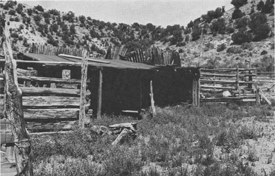
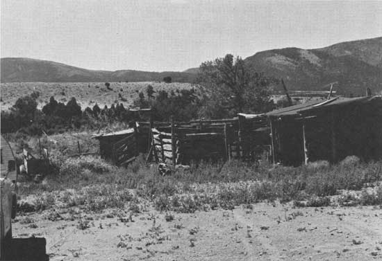
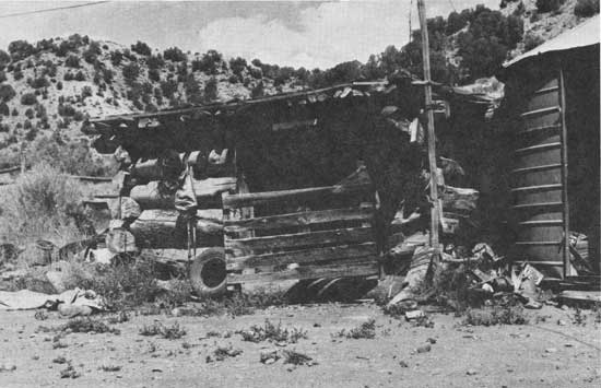
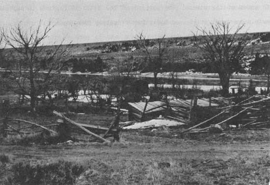
Northwest of the stone house is the Jarvie corral and stable complex constructed, partially, of the rail ties that Jarvie and young Jess Taylor fished out of the river. The entire complex runs roughly north to south for 120 feet. It is divided into three sections: two corrals and an open-faced stable. All three sections extend eastward from a common seven-foot-high wall built into a gently sloping hillside. The wall extends the entire 120 feet. The northern half of the wall is constructed of hand hewn rail ties while the southern half is made of logs.
The southern half of the complex is a square corral measuring 60' x 60'. The walls on the north, east, and south are made of rail ties while the western wall is the log section of the 120' common wall. The walls are seven feet in height and feature two gates, one on the east and one on the north.
The gate on the north opens into the second corral and the northern wall of the first corral becomes the southern wall of the second corral. The second corral is rectangular measuring 60' x 20'. The walls are all seven feet in height and are made entirely of rail ties. A gate is positioned in the center of the north wall. A shed-type stock shelter made of logs extends for six feet from the top of the 10' common wall, thus a portion of the second corral is covered.
The stock shelter extends beyond the second corral for 40 feet where it functions as an open-faced stable. The western wall of this section is the northern-most section of the 120' common wall. The eastern side is open. The sheltering roof is made of whipsawed planks and logs. On the south the stable shares a wall with the second corral while on the north a rail tie wall extends the width of the roof.
Two minor additions have been added to the complex in recent years. A tin-topped shed extends eastward from the eastern wall of the first corral and a section of the roof over the open-faced stable immediately north of the second corral has been extended approximately 13 feet toward the east.
Northeast of the corral and stable complex is the log blacksmith shop where Jarvie did "damn fine work." The shop is a single room, one story, rectangular building measuring 15' x 20'. It is constructed of cottonwood logs. The roof is made of split juniper logs and slopes slightly upward from the rear to the front of the building. The original dirt covering has been replaced by green roll roofing. One entry is located on the south side.
|
| Photo 35. East side of the stone house in 1978. (Photo Credit: Bureau of Land Management). |

|
| Photo 36. South side of stone house showing frame addition in 1978. (Photo Credit: Bureau of Land Management). |
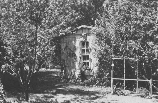
East of the blacksmith shop is the fifth Jarvie structure, a small 10' x 9' log building originally used by John Jarvie for storage, now used as a pumphouse. It is made of hewn logs with a roof of whipsawed planks. The original dirt covering has been replaced by green roll roofing. There is one door on the south side of the structure.
In addition to the five major historic buildings on the property, manmade elements comprise several other important objects and sites.
West of the dugout the ruins of the waterwheel can be seen. The bunker in which the wheel sat is still basically intact and miscellaneous pieces of hardware are scattered about, however, the great wheel itself has long since vanished. The wheel originally stood sixteen feet in diameter with paddles (possibly made of fir) approximately four feet wide to which were attached buckets about the size of an eight gallon can. The buckets were about two feet deep and ten inches in diameter. The buckets emptied into a flume that carried the water into a ditch. [220]
|
| Photo 37. Jarvie corrals in 1978 showing rail tie construction. (Photo Credit: Bureau of Land Management). |
|
| Photo 38. Jarvie corrals in 1978. (Photo Credit: Bureau of Land Management). |
|
| Photo 39. Blacksmith shop in 1978. (Photo Credit: Bureau of Land Management). |
|
| Photo 40. Corrals, sheds, stone house, and addition in 1962. (Photo Credit: Utah State Historical Society). |
The ditch itself is a historic element which still passes through the entire length of the Jarvie property. It was constructed in 1902 by Charles Crouse and is consequently known as the Crouse ditch. It originates upstream from Jarvie's where a dike was constructed across a channel of the river to divert the flow. The Crouse ditch extended beyond the Jarvie property to the site of Bridgeport where it divided, crossed the bridge on a flume, and continued down both sides of the river. The portion of the ditch which runs through the Jarvie property is still used today for irrigation purposes. [221]
A retaining wall constructed of stone and log runs for approximately sixty feet along the southern edge of the property south of the stone house. Built by Jarvie to protect his property from the waters of the river and its winter ice flows, the retaining wall helps to identify the historic course of the Green River.
The property also includes several original fences. They are constructed substantially of cedar posts and Kelly Diamond Point barbed wire. One such fence encloses most of the eastern pasture. Another encircles the orchard area which includes two producing apricot trees planted by John Jarvie.
The crumbling remains of the buckboard or mail coach chassis are a visible reminder of Brown's Park's early post office. Mail coming south from Rock Springs on the mail coach would cross the ferry and continue on to Ashley Valley on horseback. The chassis dates at least to 1887 when the Jarvie post office closed. [222]
The site of the all important Jarvie ferry can easily be identified on the bank of the river east of the stone house. The original ferry pole is still standing and lengths of the ferry cable can be found on both sides of the river.
Four graves are located on the property. One of them predates Jarvie. The others are from the Jarvie period. Many graves in Brown's Park remained unmarked until the 1940s when Ann Bassett (relying on memory) toured the Park with Esther Campbell and erected markers which were donated by a Craig, Colorado, mortuary. Some of the grave sites are disputed locally and are particularly controversial, including at least one on the Jarvie property.
The earliest grave belongs to H.M. Hook. During the summer of 1868 several prospectors, including H.M. Hook and Jesse Ewing, floated down the river from Green River Wyoming. Three boats left in secret, at night, to avoid attention. The trip was a pleasant one until the boat containing Hook suddenly dropped out of sight, plunging into a foaming whirlpool. The two following boats rowed to shore. Hook's boat surfaced bottom up; Hook's partner clinging to it. Hook, who had managed to climb onto a large boulder in the river decided to swim to shore. He slid into the water and disappeared. His body washed ashore downstream and was buried.
If the accident took place in the Red Creek rapids, which is highly probable, it is very likely that Hook would have been buried on or near what was later to become the John Jarvie property. Many early Brown's Park pioneers recall seeing the grave in their valley. J.S. Hoy said "For years after the place [Hook's grave] was noted as a landmark. 'We rode as far as Hook's grave'; 'We saw cattle across the river from Hook's grave'; and the like, people would say to indicate where they had been." [223]
Other reliable accounts, however, place Hook's grave far from Brown's Park in Red Canyon above Flaming Gorge. One of John Wesley Powell's men noted in his journal, "On the 4th of June we passed the wrecks of some boats half-buried in the sand, and on landing, we discovered a grave on a little knoll some distance back from the water, with a pine board stuck up at its head bearing the name of Hook . . . . The leader, whose bones lie in these splendid depths of Red Canyon was said to have been the first mayor of Cheyenne." [224]
Hook had, indeed, been the first mayor of Cheyenne. The fact that his widow offered $1,000.00 for identification of the body's location could, in part, explain the number of Hook "graves" in the area!
The second grave belongs to a young man by the name of Robinson. Robinson was one of the Jesse Ewing's victims. In the early days of the 1880s Robinson staked a claim too near to Jesse's property. The results are found in the Hoy Manuscript:
One winter day when Green River was in icy fetters bound, he and Jesse met on the ice. Just what took place, what
was said will never be known. After Jesse had done his part, he pursued his way homeward passing the cabin of the couple of trappers saying to them: 'If you want to see the handsomest corpse you ever saw go up yonder on the ice and you will see it,' and he passed on to his cabin high on the rock ribbed mountain side as if nothing unusual had occurred. The men found Robinson streatched out full length, dead, stabbed to the heart. Where Ronbinson came from nobody seemed to know. I believe Jesse had some sort of a judicial examination before a justice of the piece, claiming self-defense. [225]
Young Robinson was buried on the Jarvie property in 1882. In 1885 a man named Young was drowned at the wagon ford and was also buried on the ranch.
The final grave, ironically, belongs to Jesse Ewing himself. Ewing first came to Brown's Park around 1867. Local legend has it that he'd worked for the Overland stage. He had been in so many fights with Indians and grizzlies that his face was horribly scarred (as was his personality, many claim).
Ewing was a prospector and had a cabin and assay office in the canyon that now bears his name. He became acquainted with Jarvie, being one of his nearest neighbors. "Frank Jenkins found a crate addressed to Jesse Ewing Assay Co. under a ledge at the Jarvie place when he lived there. The box was found up on the hill and it had a set of brand new scales in it." [226]
Unable to support his ventures, Ewing would entice unwary partners into investing in his claims. When the money was gone he would chase them off or carve them up (Jarvie once told Jess Taylor that Ewing always carried a knife, never a gun). [227]
Ewing, tired of a bachelor's life, persuaded a certain Madam Forrestal (who at one time had sold bootleg whiskey to the Indians with Jack Bennett) to leave the red light district of Rock Springs and come to live in his cabin in Jesse Ewing Canyon.
Ewing later entered into a partnership with Frank Duncan in 1885, and the trio lived happily for a time in Jesse's cabin. Gradually, however, Madam Forrestal's affections shifted from Ewing to Duncan. Fearing that evil tempered Jesse might be getting suspicious, they began to plot against him.
The day of the killing, Duncan feigned illness remaining at the cabin all day. Late in the evening when Jesse was on his way home from an unusually hard day's work, slowly climbing the steep mountain following the narrow trail warn smooth by his own footsteps — unsuspecting of danger — Duncan lay in ambush and shot him dead — to make sure fired three or four extra bullets into the prostrate body, shot him with his own Winchester. [228]
Frank and Madam hurriedly left the area, but as they were leaving, they stopped at John Jarvie's store and told Jarvie that Ewing was sick and was asking for him. Jarvie discovered Jesse's body and with the help of Speck Williams buried it only inches from Ewing's victim Robinson. "It is not recorded that there were any mourners." [229]
The second category, non-existing Jarvie structures, comprises those elements which existed during Jarvie's occupancy of the property, but have subsequently been removed. Through oral interviews, old photographs, and early surveys the locations and descriptions of the structures have been ascertained. Although the structures are no longer present physically, the sites which they occupied have been identified and, thus, they become important to the character of the property.
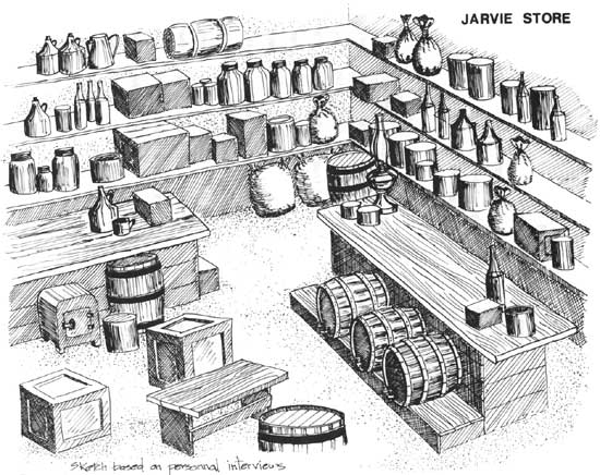
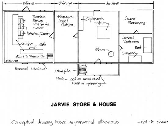
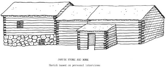
The most important missing structure is the Jarvie store and home complex. The store was a rectangular log building with a dirt roof and a stone basement. The door, on the north side of the building, was two or three feet above ground level, due to the height of the basement, and there were no stairs leading up to it, thus facilitating the unloading of goods from wagons. There was a small window high on the south wall and possibly another small one on the north wall east of the door. [230]
Counters ran along the west and south sides of the store with an opening between them in the southwest corner. Behind the counters were floor-to-ceiling shelves 2-1/2 feet wide piled with merchandise: ammunition, guns, groceries, saddles. Three whiskey barrels (hauled from Rock Springs) sat on a raised platform in front of the west counter with spigots ready for dispensing. [231] The store safe was kept in plain view in front of the south counter. There were benches to sit on in the open area in front of the counters as well as piles of merchandise, boxes, and cans of dry goods.
The Jarvie house was a log structure connected to the eastern side of the Jarvie store. Immediately east of the store was a room described as a "junk room" or a "breezeway" which was entered through a door in the eastern wall of the store. Since only the store itself sat on the stone foundation, the remainder of the store/house complex was at ground level. A three-step stairway led from the store down into the junk room.
Having no windows, the junk room was dark. It was cluttered with guns, cans, and boxes. Jarvie stored a collection of muzzle-loaders there.
|
| Figure 3. Interior sketch of the Jarvie store. |
A doorway in the eastern side of the junk room led into the house itself. It was a three-room house with a porch on the south side. Immediately east of the junk room was the kitchen. A door on the south side led to the porch. Windows were located east of the door and in the center of the north wall. Cupboards were located in the northwest corner, a table in the center of the room, and a stove south of the table. The porch (or wood shed) extended south from the kitchen. It was completely enclosed; made of rail ties. Wood was piled against the western wall. There was a doorway on the south side but no door.
Jarvies bedroom was east of the kitchen. It was entered through a door in the eastern wall of the kitchen. A dresser (which is today in the Jess Taylor home in Rock Springs) sat against the south wall. The bed was placed against the east wall. A trunk containing old guns and a pearl-handled revolver sat at the foot of the bed. A doorway in the northern wall of Jarvie's bedroom led into the second bedroom. It was a simple square room with a window in the northern wall. The Jarvie store and home complex extended to within three or four feet of the stone house.
Following the Jarvie murder young John lived on the property. He tore down the store and the house and built a new five-room house on the same spot. When Charlie Sparks purchased the property in 1924 the structure was moved to the Garrison ranch on Beaver Creek where it was later destroyed by fire. [232]
|
| Figure 4. Floorplan of the Jarvie store and home complex. |
|
| Figure 5. Sketch of the south side of the Jarvie store and home complex. |
The stone foundation of the store was still visible in 1934. [233] During the winter of that year Frank Jenkins filled in the cellar using a team and scraper. Old kerosene lamps, lamp chimneys, harnesses, and logs which had fallen into the cellar were covered over. As Marie Allen once observed: "If you dig in there, you'll find things." [234]
Two other non-existing Jarvie structures are the chicken house and outhouse. The chicken house was a log building with a door facing west and a window south of the door. It stood east of the stone house. The outhouse was located west of the store between the dugout and the Crouse ditch.
An 1898 survey of the Green River meanders indicates other structures on the property. Jarvie had a log storehouse north of the stone house, two log houses in the pasture east of the stone house, and a barn encircled by a corral west of the wagon ford. [235] A foundation remnant north of the log storehouse site indicates the existence of yet another structure.
Surveyor Adolph Jensen also noted that Jarvie had a fenced pasture upstream from the store. A pre-Crouse ditch attempt at irrigation had been undertaken, however, Jensen found the ditch to be "utterly worthless because its head is below high water and above low water and the fall of the ditch is insufficient." [236]
|
| Photo 41. 1911 photo of the Jarvie property taken by the Kolb expedition. (Photo Credit: Bureau of Land Management). |
A photograph taken by the Kolb brothers' expedition in 1911 shows another log building standing in the area immediately east of where the Jarvie chicken house stood. Jess Taylor recalls the structure as being rectangular (longer east to west than north to south), one roomed, and dirt roofed. Jarvie used it as a shop. [237]
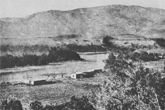
Roads led to the ferry and the wagon ford from both sides of the river. A traveler approaching from either direction in the 1890s, when all of the buildings were still standing, would surely know that he was nearing a substantial settlement. The Jarvie Ranch, at that time, was, indeed, the Brown's Park hub of commerce and transportation.
The third category, existing post-Jarvie structures and objects, includes features which were added to the property after the Jarvie period and are still in existence today.
The most noticeable addition is a modern mobile home which was moved to the property by the Campbells in the late 1960s. It is a 35 foot, double-wide, three-bedroom home. A 35' x 15' redwood frame addition, divided into two rooms, and a 5' x 18' porch connected to the addition were later added to the north side of the home. The mobile home does not set on a permanent foundation; the addition does.
|
| Photo 42. Chicken house and pump house in 1978. (Photo Credit: Bureau of Land Management). |
A metal Butler Building granary stands immediately east of the Jarvie blacksmith shop and a small metal wellhouse stands immediately east of the log storehouse (which is now used as the pumphouse). A log chicken house stands only inches to the west of the log storehouse. It was constructed in the 1930s by Frank Jenkins. There is one door on the south side and a window east of the door.
Several fences (a buck pole fence east of the mobile home, a three-sided fence attached to the west side of the corral complex, and a wire deer fence east of the buck pole fence), a loading chute attached to the north end of the corral complex, a foot bridge over the Crouse ditch, and an irrigation pump-pipe-ditch system which merges with the old ditch are all modern additions to the property. Several pieces of antique farm machinery have recently been moved to the property and now line a section of the old Crouse ditch.
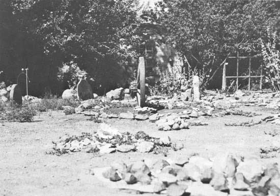
The final existing post-Jarvie feature is the Campbell Rock Garden. Beginning in 1938, Duward and Esther Campbell collected unique minerals and geological forms as well as Indian artifacts. These have been arranged over a large area (where the Jarvie chicken house once stood) in attractive geometric designs. The rock garden includes many metates and several hundred manos, scrapers, manti boards, hammer stones, and spear points all from Brown's Park and the surrounding area. The garden is one of the site's most popular features.
|
| Photo 43. A portion of the Campbell Rock Garden in 1978. (Photo Credit: Bureau of Land Management). |
The last category, non-existing post-Jarvie structures and objects, includes those elements which were built on the property following Jarvies murder and existed for a time, but no longer remain. They are not historically important; however, their sites have been identified and they do tell us something about the development of the property.
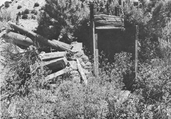
A bunkhouse, granary, and hog pen are classified as the non-existing post-Jarvie features. The bunkhouse was a one-room log building approximately 10' x 12'. It stood between the dugout and the Crouse ditch. The remains of the wind generator and a bunk mark the spot today. The granary was a one-room log building situated to the west of the ferry pole. It had one south-facing door and a north-facing window. The roof sloped from the south up to the north. The hog pen encircled the granary. Several of the posts remain in place today indicating that the hog pen and the Jarvie pasture fence were connected at one time. [238]
The bunkhouse, granary, and hog pen were all built by Sparks or Jenkins since they postdated Jarvie and predated Allen. They were all destroyed by a fire in the 1950s. The fire originated in the bunkhouse where, unfortunately, many of Marie Allen's historical notes and photographs were stored. The fire spread along the river to the pasture where it burned the hog pen and granary. Luckily the central portion of the ranch around the stone house was irrigated and was thus bypassed by the fire as it moved downstream.
| <<< Previous | <<< Contents>>> | Next >>> |
ut/7/chap4.htm
Last Updated: 21-Nov-2008