National Park Service LogoU.S. Department of the InteriorNational Park ServiceNational Park Service
National Park Service:  U.S. Department of the InteriorNational Park Service Arrowhead
Oxon Cove Park & Oxon Hill Farmclose-up of becky's, the draft horse, eye
view map
text size:largestlargernormal
printer friendly
Oxon Cove Park & Oxon Hill Farm
Nature & Science
 
oxon run

NPS Photo

Looking downstream towards Virginia along Oxon Run, a moderate sized stream that broadens into a wide shallow estuary before joining the Potomac River.

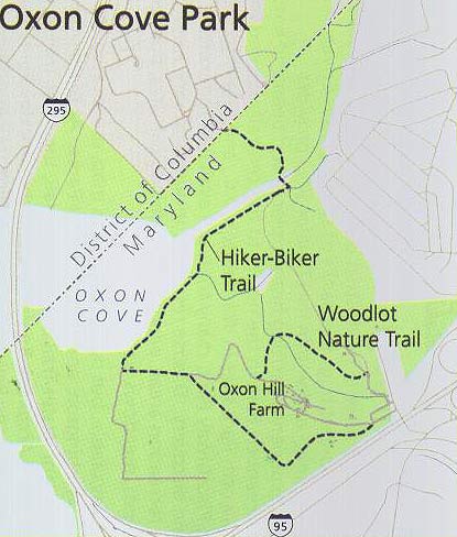
Oxon Hill Farm and the natural areas of Oxon Cove Park comprise a rich, diverse ecosystem that supports a wide variety of plant and animal life. 

The topography of the park consists of two general zones:  an area of broad Potomac River Floodplain and a high upward terrace. The upland terrace is cut and divided by several small intermittent drainages and descend to the floodplain. The floodplain is crossed by Oxon Run, a stream that broadens into a shallow estuary before joining the Potomac River. Oxon Run itself has been trained and rationalized by U.S. Army Corps of Engineers, so that its course only partially follows its original path.

Oxon Cove Park offers two trails that allow visitors to walk on their own pace to explore some of the natural features of the park. These trails are the .3 mile Woodlot Trail and the Hiker - Biker Trail which is 1.6 miles.


arrowhead
Nature and Science in the National Park Service
Explore nature and preservation efforts in national parks
more...
logo for USGS
USGS Bird Inventory of Oxon Cove Park
Find out about the birds who live in Oxon Cove Park
more...
OXCO 1891  

Did You Know?
In 1891, Saint Elizabeths Hospital, acquired the Oxon Cove Park Property, to establish a farm where patients, removed from the confines of a hospital setting, could benefit from fresh air and outdoor work at this new "farm colony." This hospital farm was called Godding Croft.

Last Updated: September 28, 2006 at 10:00 EST