National Park Service LogoU.S. Department of the InteriorNational Park ServiceNational Park Service
National Park Service:  U.S. Department of the InteriorNational Park Service Arrowhead
Oregon National Historic Trail As Missouri River communities moved further upstream so did
view map
text size: largest larger normal
printer friendly
Oregon National Historic Trail
Auto Tour Route - Wyoming

Below are driving directions to follow The Oregon National Historic Trail west through Wyoming, from Nebraska to Idaho. A simple map showing the general route is below the directions.
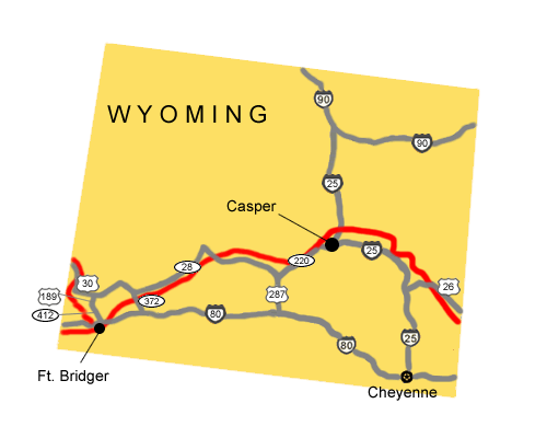
  1. Take U.S. Route 26 west to Interstate 25.
  2. Turn north onto Interstate 25.
  3. Take Interstate 25 west to State Route 220.
  4. Turn west onto State Route 220.
  5. Take State Route 220 to U.S. Route 287.
  6. Turn west onto U.S. Route 287.
  7. Take U.S. Route 287 west to State Route 28.
  8. Turn West onto State Route 28.
  9. Take State Route 28 west to State Route 372.
  10. Turn southeast onto State Route 372.
  11. Take State Route 372 east to Interstate 80.
  12. Turn west onto Interstate 80.
  13. Take Interstate 80 west to State Route 412.
  14. Turn north onto State Route 412.
  15. Take State Route 412 to U.S. Route 189.
  16. Turn north onto U.S. Route 189.
  17. Take U.S. Route 189 north to U.S. Route 30.
  18. Turn west onto U.S. Route 30.
Total original route miles in Wyoming: 491

 
Map image of the auto tour route driving directions across Wyoming.
NPS Image
Map image of the auto tour route driving directions across Wyoming.

You are exiting the National Park Service website

Thank you for visiting our site.

You will now be redirected to:

We hope your visit was informative and enjoyable.

Last Updated: December 05, 2011 at 11:27 MST