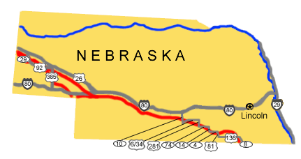
Below are driving directions to follow the Oregon National Historic Trail west through Nebraska, from Kansas to Wyoming. A simple map showing the general route is below the directions.
To follow the trail north from Kansas State Route 148:
After crossing the Kansas/Nebraska state line, the route becomes SR112.
-
Follow it north to State Route 8, then west to Fairbury, NE.
-
Turn west onto U.S. Route 136.
-
Take U.S. Route 136 west to State Route 5.
-
Turn north onto State Route 5.
-
Take SR 5 north to State Route 4.
-
Turn west onto State Route 4.
-
Take SR 4 west to State Route 14.
-
Turn north onto State Route 14.
-
Take SR 14 north to State Route 74.
-
Turn west onto State Route 74.
-
Take SR 74 west to U.S. Route 281.
-
Turn north onto U.S. Route 281.
-
Take U.S. Route 281 north to U.S. Route 6 & 34.
-
Turn west onto U.S. Route 6 & 34.
-
Take U.S. Route 6 and 34 west to State Route 10.
-
Turn north onto State Route 10.
-
Take SR 10 north to U.S. 30.
-
Turn west onto U.S. 30.
-
Take U.S. 30 west to U.S. Route 385.
-
Turn north onto U.S. Route 385.
-
Take U.S. Route 385 north to State Route 92.
-
Turn west onto State. Route 92.
-
Take SR 92 through Gering and Scotts Bluff Nat'l. Monument to State Route 29.
-
Turn north onto State Route 29.
-
Take SR 29 north to U.S. Route 26.
-
Turn west onto U.S. Route 26 to the Wyoming border.
To follow the northern cutoff, follow directions 1-18 above, then:
19. Instead of taking U.S. 30 west to U.S. Route 385, take U.S.. Route 26 west at Ogallala.
20. Turn northwest onto U.S. Route 26.
21. Take U.S. Route 26 west to State Route 92.
22. Turn southwest onto State Route 92.
23. Take SR 92 west through Gering and Scotts Bluff Nat'l. Mon. to State Route 29.
24. Turn north onto State Route 29.
25. Take SR 29 north to U.S. Route 26.
26. Turn west onto U.S. Route 26 to the Wyoming border.
Total original route miles in Nebraska: 424