
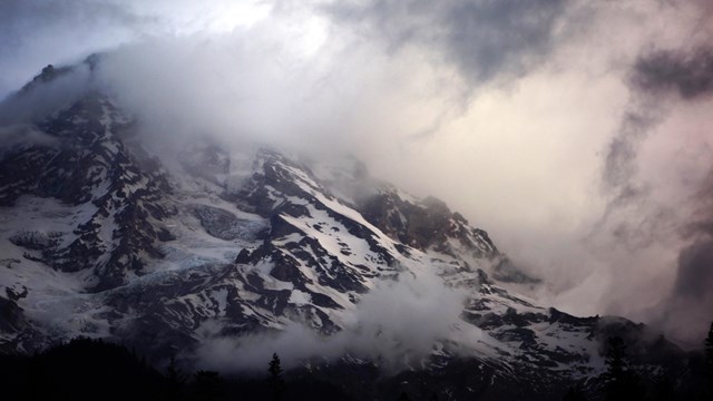
NPS Photo Rain Around the MountainIt is hard to imagine that several days of rain in a wet region such as the Pacific Northwest would close a national park for six months. But when copious amounts of water rushed down hillsides and roads and overfilled the rivers within Mount Rainier National Park’s boundaries, the end result was a loss of campgrounds, roads, trails and utilities. A steady rain began falling around 1 p.m. on Sunday, November 5 and continued through mid-afternoon on Tuesday, November 7, 2006. Varying amounts of precipitation reached the ground throughout the park from Carbon River to Ohanapecosh. Nearly 18 inches of rain was recorded at Paradise. As the ground was already saturated from a week of drizzle, rain and snow, most of the water flowed over roadways and across the landscape into the rivers. Old growth trees in the path of the rushing water were uprooted. Bridges, trails and roads were removed from their strongholds and took their place alongside rolling boulders in the raging water. Rivers and creeks changed channels cutting new paths and leaving old ones dry. 
NPS Image Flood DamageOn November 6 and 7, 2006, Mount Rainier National Park received almost 18 inches of rainfall in 36 hours. Rivers and streams all over the park overwhelmed their channels, with floods that exceeded anything the park has experienced in its 108-year history. The National Park Service estimates that damage to roads, trails, campgrounds, and buildings exceeded $36 million. 1) Sunshine PointThe Nisqually River breached protective levees to reclaim about five acres of land at Sunshine Point, including 200 yards of the park road and much of Sunshine Point Campground. The park’s main utility lines were broken, including the buried cable that provides commercial power to Longmire and Paradise. 2) Westside RoadFlooding from Tahoma Creek damaged long stretches of this dirt road. 3) Kautz CreekKautz Creek changed course about a mile above the road bridge and flowed instead through the forest and across the park road 200 yards east of the bridge. The flood undermined the road, damaged the buried power line, and caused severe erosion through the Kautz Helibase and maintenance yard. 4) Nisqually RoadThe Nisqually River severely eroded the bank of the roadway in two places, at mileposts 5.2 (a mile below Longmire) and 9.1 (a mile above Cougar Rock Campground). At both locations the flood left the roadway partially unsupported above a sheer drop off, and in danger of collapsing into the river. 5) LongmireThe Nisqually River destroyed long stretches of levee at Longmire, eroding the bank on both sides of the channel. On the north side, the river undercut a corner of the park’s Emergency Operations Center. On the south side, the park’s service road washed out in several places. Power and sewer lines were destroyed where they crossed the river, and the water system was flooded with debris. 6) ParadiseLike the one at Longmire, the water reservoir at Paradise filled with mud and debris during the storm. Freezing weather following the storm burst a water pipe in the Paradise Inn, under renovation at the time, causing some water damage. 7) Stevens CanyonThe Stevens Canyon Road washed out in three places. This road is typically buried by snow that time of year, so the full extent of the damage could not be determined immediately. The worst washout, on Backbone Ridge on the east end of the road, sits atop a landslide that sweeps thousands of feet down to the Ohanapecosh River. 8) OhanapecoshThe Ohanapecosh River destroyed several campsites at the end of “C” loop. High winds toppled numerous trees. Water runoff pooling behind the Visitor Center caused water damage to the building’s walls and floors. 9) The Grove of the PatriarchsFlooding buried this popular island of old growth trees in a layer of silt four feet deep. The debris-laden Ohanapecosh River destroyed the suspension bridge leading to the island, and knocked the boardwalk through the grove off its foundations. 10) Highway 123This major highway through the park washed out in four places. One washout, at Milepost 11.5, cut across both lanes to a depth of 70 feet. Buried by winter snowpack; it was feared that spring runoff could cause further damage. 11) Highway 410The White River overflowed its banks during the storm, inundating Highway 410 for several miles. However, the highway does not appear to have sustained any long-term damage. 12) White River Road and CampgroundErosion caused damage to campsites and an amphitheater along the edge of the White River. The shoulders of the campground’s access road were also eroded. 13) Mt. Fremont and Gobbler’s Knob Fire LookoutsEither during the storm in November or a severe windstorm in December, high winds tore the roofs from the historic Mt. Fremont and Gobbler’s Knob fire lookouts. At Gobbler’s Knob, two of the walls caved in as well. 14) Carbon RiverFlooding from the Carbon River partially or completely destroyed two miles of road between the park entrance and Ipsut Creek Campground. In places, only culverts and road signs remain to remind visitors that new river channels used to be roadways. The historic Ipsut Creek Cabin was undermined when a channel of the river flowed directly beneath it. The windstorm in December toppled dozens of trees across the damaged roadway. 15) TrailsMost of Mount Rainier’s trails were still buried under snow, so a complete survey of the damage was not immediately possible. However, the flood destroyed most of the park’s low-lying trail bridges. Major sections of trail collapsed or were scoured down to bedrock, and needed to be rerouted or rebuilt. Details of the November 2006 Flood
Weather
The weather can change quickly at Mount Rainier, from calm to stormy and back again. Check the weather to prepare for a safe visit. 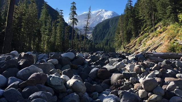
Geohazards
Mount Rainier is an active volcano. Learn more about debris flows and other geologic hazards of this unusual environment. 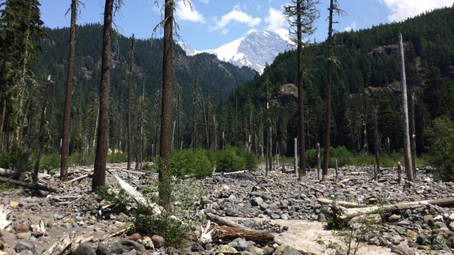
Aggradation
Aggradation, the process of rivers filling with rocky debris, can play a big role in flooding and other river behavior. |
Last updated: January 27, 2025