Best Farm Slave Village: Archeology

The location of the L'Hermitage slave village was first identified in 2003 but only limited excavations were undertaken. A more focused investigation began 2010 and resulted in the discovery of six individual slave quarters as well as a number of associated features.

In order to get a sense of the site's archeological potential, shovel test pits (STPs) were excavated. The map below shows the grid of 183 STPs that were excavated. Starred locations indicate areas where archeologists found materials warranted further excavation.

Click on the starred STPs to see what was found.

Further information on the archeology of L'Hermitage can be found in this article:
The Enslaved Community of L’Hermitage.

 
A computer made map showing the location of shovel test pits done during the archeological survey at the Best Farm.
Shovel Test Pits (STPs) were excavated at a 20 foot interval with areas of interest excavated at closer intervals. Starred STPs indicate areas that warranted more extensive investigation with excavation units (EUs). Click on the starred STPs to learn more.
Location of Structure F - Hearth, and Midden Location of Structure C - Hearth Location of Structure D - Hearth and brick pit Location of Structure E - Hearth Location of Structure F - Hearth

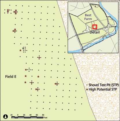
Last updated: March 28, 2024

Park footer

Contact Info

Mailing Address:

4632 Araby Church Road
Frederick, MD 21704

Phone:

301 662-3515
Visitor Center Phone Number

Contact Us

Tools