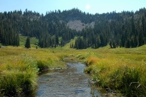
Start: Hat Lake parking area This scenic trail climbs gradually along a creek to a cliff encompassed meadow. The trail begins on the west side of Hat Lake. Small side trails lead to the lake edge which offers excellent views of the south side of Lassen Peak. After a half mile, the trail beings to climb as it enters a narrow ravine boarded by a tributary of the west fork of Hat Creek. The trail steepens again and the sound of rushing water grows louder. At this point, the forest thins and opens up to views of a tumbling waterfall. As the trail continues more gradually to the turn off to the Terrace Lake trail a number of small waterfalls come into view. At the trail intersection, follow the trail right and across the footbridge to continue 1.3 miles to the Terrace Lake trail. Or follow the trail 0.1 mile to the edge of Paradise Meadows. Here the trail ends and hikers can wander through the thick meadow grasses scattered with paintbrush, clover, lupine, gentian and other meadow wildflowers. Hikers may also follow the stream along its windy trail through the meadow as far as the talus fields that line the cliffs. The peaks Mount Conard and Lassen Peak are just visible hovering above the cliffs that surround this colorful meadow. The Hat Lake parking area is located 9 miles from the northwest entrance and 19 miles from the southwest entrance on the park road. Cross the street to the marked trailhead on the east side of Hat Lake. Potable water is NOT available at the trailhead. |
An official website of the United States government
Here's how you know
Official websites use .gov
A
.gov website belongs to an official government
organization in the United States.
Secure .gov websites use HTTPS
A
lock (
) or https:// means you've safely connected to
the .gov website. Share sensitive information only on official,
secure websites.
