
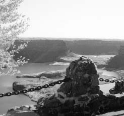
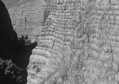
The upper Grand Coulee is probably the world’s finest example of a recessional waterfall gorge. (NPS Photo)
|
Ice Age Floods |
|
s u m m a r y |
|
|
The Criteria for Parklands requires that any proposed new National Park Service unit be both “suitable” and “feasible,” and that other factors, such as “rarity and integrity of the resources” also be considered. Based upon an evaluation of natural history themes, and history/prehistory themes, the Ice Age Floods region is suitable for inclusion in the National Park System. It is feasible to interpret the Floods story across four states, especially if there is a high degree of cooperation among the states and federal agencies. The Floods region is considered to have a high degree of rarity because of the size and extent of the Floods, the uniqueness of Floods features, similarities with the Mars landscape, and the fact that there is no other area like this in the National Park System. |
Since the Ice Age Floods Study of Alternatives is being conducted under the Criteria for Parklands, one of the principal analyses required is an examination of both the suitability and feasibility of the resources of the Floods region to be part of the National Park System.
1. Suitability
The Criteria for Parklands defines suitability as follows:
An area is considered suitable for addition to the National Park System if it represents a natural or cultural theme that is not already adequately represented in the National Park System, or is not comparably represented and protected for public enjoyment by other federal agencies; tribal, state, or local governments; or the private sector. Adequacy of representation is determined on a case-by-case basis by comparing the potential addition to other comparably managed areas representing the same theme or resource type, while considering differences or similarities in the character, quality, or combination of resource values. Other essential comparisons include: representation of one of the most important examples of a particular resource type in the country, rarity of the resources, and interpretive and educational potential. The comparison results in a determination of whether the proposed new area would expand, enhance, or duplicate resource-protection or visitor-use opportunities found in other comparably managed areas.
The National Park Service uses a series of natural and cultural themes to evaluate potential areas for inclusion in the National Park System (see Section G). The themes are evaluated by two criteria: 1) Significance and 2) Adequacy of representation within the National Park system.
A mass of compressed air preceded the towering wall of flood water. The roar would have increased in intensity beginning a half hour before the onrushing flood struck. The winds reached hurricane strength, uprooted trees, created a blinding dust storm, and caused a shift in microclimate resulting in sudden and severe rainfall.
|
The upper Grand Coulee is probably the world’s finest example of a recessional waterfall gorge. (NPS Photo) |
National Park Service Themes
The National Park Service has developed a thematic framework for evaluating potential and existing units within the National Park System. These themes are found in a two-volume set covering the Natural History and History and Prehistory of the United States. In addition, there is a revised statement for cultural history, which was added June 28, 1994. The basic thematic framework was developed in the 1960s and the cultural history element has been updated to reflect current knowledge or appreciation of events or trends over the past 40 years. The NPS themes can be used to identify areas of national significance that are not currently reflected in the National Park System or to enhance existing interpretive programs. By its very nature, an area the size of the Ice Age Floods Region will have more than one or two themes as would be typical of smaller NPS units. The themes used for the Ice Age Floods cover Natural History themes and sub-themes, as well as the History and Prehistory themes.
The themes and sub-themes for natural history that relate to the Floods region are:
|
Regional Themes |
Sub-themes |
|
Landforms of the Present |
Mountain Systems |
|
Works of Volcanism |
|
|
Sculpture of the Land |
|
|
Eolian Landforms |
|
|
River Systems and Lakes |
|
|
Works of Glaciers |
|
|
Geologic History |
Oligocene to Present |
|
Land Ecosystems |
Tundra |
|
Boreal Forest |
|
|
Dry Coniferous Forest |
|
|
Grassland |
|
|
Desert |
|
|
Aquatic Ecosystems |
Marine Environments |
|
Estuaries |
|
|
Lakes and Ponds |
Themes for History and Prehistory
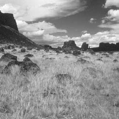
As the floods escaped the channels, the water spread out, leaving boulder-strewn plains. (NPS Photo) |
Major Themes
Collectively, five of the nine NPS themes and the interrelationship among them, indicate that there is a remarkable opportunity to present visitors to the Floods region a broad picture of the Nation’s natural and culture history from 36.6 million years ago (the Oligocene Epoch) to the present. Emphasis would be on the period of the Floods and subsequent human interaction with the Floods landscape.
Physiographic Regions
The J Harlen Bretz Interpretive Center at Sun Lakes–Dry Falls State Park, Washington, is a major Floods interpretive site on State Route 17 (NPS Photo). |
|
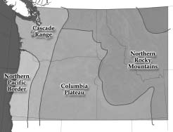
Physiographic Regions of the Floods region |
The National Park Service, using Fenneman’s Physiographic Divisions of the United States (1929) as a basis, divided the United States into 23 separate natural regions or provinces. Four of the regions fall within the scope of the Ice Age Floods proposal:
The genesis of the Ice Age Floods began with a lobe of the Cordilleran Ice Sheet damming a large river flowing westward out of the Northern Rocky Mountains and impounding an immense lake in western Montana. The ice dam failed a number of times and waters tore across the landscape of the Columbia Plateau and through the breach in the Cascades now called the Columbia Gorge. The flood waters backed up and inundated the Willamette Valley before rushing down the lower Columbia River to the Pacific Ocean through the region now known as the North Pacific Border. Rarely has a study of alternatives covered such a vast area that it includes parts of four physiographic regions. Public understanding of the tremendous size and scope of the existing Floods remnants can only be achieved if the full geographic extent of the phenomena is included.
Evaluation of the Natural History Themes
The following four charts address the Significance and Adequacy of Representation of the natural resources within the study area. It should be noted that the NPS’s Natural History evaluations were completed in the 1960s, almost two full decades before J Harlen Bretz’s and J. T. Pardee’s hypotheses were widely accepted by the scientific community. Since the late 1970s, the academic and geologic communities have tested the catastrophic flood theory and found that Bretz’s and Pardee’s concepts could be supported and proven. The NPS Natural History evaluations, however, illustrate the awareness of a number of subthemes not represented within the National Park System.
North Pacific Border
NPS Representation |
Adequate Representation in NPS |
Little or No Representation in NPS |
||
Significant Levels |
Significant |
Prime Significance |
Significant |
Prime Significance |
a. Mountain Systems |
||||
b. Sculpture of the Land (see note 1) |
||||
c. Eolian Landforms |
||||
d. River Systems and Lakes |
||||
e. Work of Glaciers |
||||
f. Oligocene to Present (see note 2) |
||||
g. Tundra |
||||
h. Boreal Forest |
||||
i. Pacific Forest |
||||
j. Dry Coniferous Forest |
||||
k. Chaparral |
||||
l. Marine Environments |
||||
m. Estuaries |
||||
n. Lakes and Ponds |
||||
Cascade Range
NPS Representation |
Adequate Representation in NPS |
Little or No Representation in NPS |
||
Significant Levels |
Significant |
Prime Significance |
Significant |
Prime Significance |
a. Mountain Systems |
||||
b. Works of Volcanism |
||||
c. Hot Water Phenomena |
||||
d. Sculpture of the Land (see note 3) |
||||
e. River Systems and Lakes |
||||
f. Work of Glaciers |
||||
g. Caves and Springs |
||||
h. Oligocene to Present |
||||
i. Tundra |
||||
j. Boreal Forest |
||||
k. Pacific Forest |
||||
l. Dry Coniferous Forest |
||||
m. Lakes and Ponds |
||||
Note 1. Numerous streams and rivers have shaped the landforms within the North Pacific Border prior to, during, and after the Ice Age Floods. During that time period sea level was 500 feet lower, creating the Astoria Canyon, which was steepened by the Floods.
Note 2. The Geologic History sub-theme was added because during the Miocene Epoch (23.7 to 5.3 million years ago), the Columbia Plateau Back Arc spread volcanism throughout the study area. During the Pleistocene Epoch (1.8 to 0.1 million years ago), the Continental Glaciers descended on the Northwest and multiple Ice Age Floods from Glacial Lake Missoula impacted the study area.
Note 3. Numerous streams and rivers cut deep gorges into the rocks and landforms of the Cascades prior to, during, and after the Ice Age Floods.
Columbia Plateau
NPS Representation |
Adequate Representation in NPS |
Little or No Representation in NPS |
||
Significant Levels |
Significant |
Prime Significance |
Significant |
Prime Significance |
a. Plains, Plateaus, Mesas |
||||
b. Mountain Systems |
||||
c. Works of Volcanism |
||||
d. Sculpture of the Land |
||||
e. Eolian Landforms (see note 4) |
||||
f. River Systems and Lakes |
||||
g. Work of Glaciers |
||||
h. Oligocene to Present |
||||
i. Tundra |
||||
j. Boreal Forest |
||||
k. Dry Coniferous Forest |
||||
l. Grassland |
||||
m. Desert |
||||
n. Lakes and Ponds |
||||
Note 4. Windblown silt was a significant source of soil deposition within the Columbia Plateau.
Northern Rocky Mountains
NPS Representation |
Adequate Representation in NPS |
Little or No Representation in NPS |
||
Significant Levels |
Significant |
Prime Significance |
Significant |
Prime Significance |
a. Mountain Systems |
||||
b. Sculpture of the Land (see note 5) |
||||
c. River Systems and Lakes |
||||
d. Work of Glaciers |
||||
e. Oligocene to Present (see note 6) |
||||
f. Tundra |
||||
g. Boreal Forest |
||||
h. Pacific Forest |
||||
i. Dry Coniferous Forest |
||||
j. Lakes and Ponds |
||||
Note 5. Numerous streams and rivers have shaped the landforms within the Northern Rocky Mountains prior to, during, and after the Ice Age Floods.
Note 6. The Geologic History sub-theme was added because during the Miocene Epoch (23.7 to 5.3 million years ago), the Columbia Plateau Back Arc spread volcanism throughout the study area. During the Pleistocene Epoch (1.8 to 0.1 million years ago), the Continental Glaciers descended on the Northwest and multiple Ice Age Floods from Glacial Lake Missoula impacted the study area.
|
c o n c l u s i o n |
|
|
Within the four physiographic regions of the Ice Age Floods region, there are four sub-themes with “Prime Significance and no representation,” and seventeen sub-themes with “Significant and no representation.” This analysis supports the contention that there is a substantial gap in the adequacy of natural history representation of the Columbia Plateau within the National Park System. There are also areas of significance in the North Pacific Border and the Northern Rocky Mountains. |

|
|
|
The Route of the Oregon Trail and the Ice Age Floods. In 1841 the first of the great wagon trains descended the steep Blue Mountains, passed the site of present-day Pendleton, Oregon, and entered onto the sandy and gravel-strewn bottom of an Ice Age floodlake. The emigrants’ wagons had narrow metal wheel rims that cut into the sand and gravel and mired the wagons. To avoid the terrible conditions and find firm ground, later the settlers stayed 5 to 7 miles south and parallel to the Columbia River until they crossed John Day River. It wasn’t until the wagons reached the present location of Biggs, Oregon, that they saw the Columbia River. The emigrants’ goal was the rich soil of the Willamette Valley—deposited there by the Ice Age Floods. |
|

|
Evaluation of the Cultural History Themes
Cultural History themes overlie the regional landscapes included in the Ice Age Floods study area and complement the Natural History themes. These themes are integral to the interpretive story of the Ice Age Floods. Through analysis, it was determined that five of eight Cultural History themes were applicable to the study region. While the evaluation of Cultural History themes is independent of the geologic story of the Floods, they do “round out” the interpretive story for the Ice Age Floods region.
Peopling Places, Theme I
Nez Perce National Historical Park, Whitman Mission National Historic Site, and Lake Roosevelt National Recreation Area all interpret the culture of the local Native American People, but there is no comprehensive overview of the Plateau people in the National Park System or any other federal, state, or local agency. Interpretive signing throughout the Floods region would expose visitors to the rich culture of the diverse tribes and bands at appropriate sites along the Columbia Plateau and River.
Early British explorers and fur traders and Lewis and Clark’s “Corps of Discovery” traversed the heart of the Ice Age Floods region in the early 1800s. In 1809 David Thompson of the North West Company established the trading post “Saleesh House” at Thompson Falls on the Clark Fork River. Lake Roosevelt NRA and Nez Perce NHP tell the story of the fur trade, and Nez Perce NHP, Lewis & Clark National Historic Trail, and Fort Clatsop National Memorial interpret the saga of Lewis and Clark. A coordinated interpretive approach would tie the exciting early history of the Northwest together and correct such omissions as the recognition and location of Saleesh House.
In the middle 1800s thousands of emigrants traveled the Oregon Trail along the Columbia River from below Wallula Gap to Oregon City to settle in the fertile Willamette Valley. The Oregon Trail is adequately interpreted, but additional sites along the Columbia River could add to the quality of interpretation. The U.S. Army played an important role in surveying and constructing roads across the Columbia Plateau and Northern Rocky Mountains. This facet of Northwest history is not covered adequately in the National Park System. In many places the pathway of the Floods created a topography that aided in patterns of movement and settlement of the Northwest.
The discovery of gold and other precious metals in eastern Washington, northern Idaho, and western Montana brought streams of miners, travelers, and explorers into this sparsely settled area. Gold and silver were the source of great wealth and contributed to the rapidly changing settlement patterns in the mountains of the Northwest.
Developing the American Economy, Theme V
Extractive industries have always been tied to the development of the Northwest. As the wealth of the minerals, timber, water, and grazing land was realized, national and international business interests became involved in the economies of the Northwest. Miners searching for metals and other precious minerals focused their interest in northern Idaho and western Montana. The timber industry, utilizing private and public lands, produced timber products that enhanced local and regional economies. Fishing and the raising of livestock completed the triad of extractive industries through boom and bust. Nez Perce NHP interprets early mining in the area but misses the large number of mining sites in the Panhandle of Idaho. Grant-Kohrs Ranch National Historic Site, Deer Lodge, Montana, interprets ranching as it was near the Continental Divide.
Power and energy industries that made day-to-day lives easier for people throughout the region also helped develop the Northwest. During the last half of the 20th century, atomic energy and hydroelectric plants provided cheap energy for homes and businesses. Hydroelectric dams also provided dependable irrigation water for agricultural uses in what became known as the Inland Empire. The majority of these businesses unknowingly utilized remnants of the Floods—resources such as steep canyons, carved coulees, gravel bars, and scoured riverbeds—to construct their facilities.
In the early 1880s agriculture played an important part in the settlement of the Northwest. Wheat became the major crop for farmers in central and eastern Washington. When large amounts of water for irrigation became available in the 1940s, orchards and vineyards sprang up along the rivers and lands within the Columbia Basin Irrigation Project.
Riverboats and overland trails were the major forms of transportation during the early settlement of the Northwest. When the railroads expanded into the Northwest, railroad representatives sold land cheaply to farmers in order to develop a source of agricultural products. These products were then shipped to market and finished goods returned for sale to the farmers by a network of rails.
The development and the contribution of power, agriculture, and transportation are not interpreted comprehensively within the region.
Expanding Science and Technology, Theme VI
The disciplines of Physical Geography and Geology both have made extensive use of the Ice Age Floods region. In many parts of the Northwest, past geologic processes can be clearly seen because of the arid climate, lack of vegetation, and sheer scale of the geological events. Physical geography and geology come alive and are more easily understood when a visitor stands at Dry Falls gazing at the water-carved plunge pools, or discovers the strand (highwater) lines of a former glacial lakeshore 900 feet above the city of Missoula, Montana.
Transforming the Environment, Theme VII
The Ice Age Floods did much to alter the visual and physical character of the landscape along the pathways of the Floods. Although their impacts may have been less dramatic, man-made impacts have also transformed the environment. With the increase of population in the Northwest came the rapid development of towns and cities and problems associated with urbanization. Accompanying industrial development in the timber industry, mining, agriculture, and hydroelectric power generation contributed to additional transformation of the regional environment.
The Great Depression and the New Deal drastically changed the economies and landscape of the Columbia Basin with the development of Grand Coulee Dam and the Columbia Basin Irrigation Project. Today, the effects of irrigating the Basin can be seen in many areas within the Channeled Scablands of central Washington. The U.S. Bureau of Reclamation has an outstanding visitor center at Grand Coulee Dam that interprets the dam and irrigation project.
Changing Role of the United States in the World Community,
Theme VIII
At the top-secret Hanford plant, located near Richland, Washington, plutonium was produced for use in one of the atomic bombs used to end World War II. The plant got most of its power from Coulee Dam and continued to provide material for atomic weapons and other uses for the United States through the Cold War era. The Columbia River Exhibition of History, Science and Technology in Richland, Washington, has several excellent exhibits that focus on development and life at Hanford during World War II.
“The majestic [Grand] Coulee tells a heroic tale of vanished power far transcending that of Niagara, and beggering the leisurely story of ... even the Grand Canyon of the Colorado.”
J Harlen Bretz
Rarity and Integrity of the Resources
Public Law 105-391, Title III, “Additional Areas for National Park System,” specifies that in addition to the test of “suitability and feasibility,” consideration be given to a number of other factors, including “the rarity and integrity of the resources.”
Rarity
The Ice Age Floods of the Pacific Northwest are the greatest scientifically documented floods known to have occurred in North America and are considered by geologists to be truly unique. It should be noted, however, that once geologists accepted the idea of catastrophic flooding, evidence of such events, and of glacial lakes, was found in Europe, Asia, and North America. Thousands of lakes were formed when ice started to melt, filling up deep valleys that were dammed up by silt, gravel, ice, and clay. Many of these lakes have drained over the years, but some still remain, including Lake Pend Oreille, Coeur d’Alene Lake, and Flathead Lake. Even those that have long since disappeared have left signs of their existence with features such as visible shorelines, lake strata, and outlet channels.
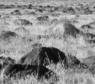
Evidence of catastrophic flooding, such as this boulder field, stretches from western Montana, to the Willamette Valley, and to the mouth of the Columbia River. (NPS Photo) |
Other Ice Age Floods
The largest known glacial lake is Lake Agassiz, which was named after Louis Agassiz, a Swiss-born geologist who gathered information on glaciers throughout Europe and North America. Agassiz was considered the “father” of the Ice Age concept. The lake is located in the Canadian Providence of Manitoba where Lake Winnipeg currently exists. Lake Agassiz was formed at the edge of the retreating glaciers around 8,000 years ago. It covered an area more than four times the size of Lake Superior. When the ice dam holding the water collapsed, the resulting flood was enormous. Scientists estimate that globally the level of the ocean rose by 20 to 40 centimeters as a result of this flood! Unlike the Ice Age Floods, Lake Agassiz only flooded once, but it dramatically changed the landscape of the region.
Ice Age Lake Bonneville, which existed around 14,500 years ago, covered more than 20,000 square miles in Utah and parts of Idaho and Nevada. For hundreds of years, the water level of Lake Bonneville maintained a fairly constant level. The water level dropped almost 400 feet when part of Red Rock Pass, which was holding back the water, eroded. The floodwaters flowed down the Snake River and joined the Columbia River near the Tri-Cities. For a short period of time, the resulting floodwaters from Lake Bonneville increased the size of the Snake River and the Columbia River by more than 20 times their normal flow. After the flood occurred, the water levels of the Great Salt Lake eventually subsided close to what they are now. Lake Bonneville drained only once, with catastrophic results.
Catastrophic floods also occurred in the Kuray Basin, which is located in the Altay Mountains in south central Siberia. The glacial lake in Kuray Basin was formed when ice filled the Aktash Valley and a glacier blocked the Chuja River in the Madjoi River Valley. The floods occurred when the ice dam holding back the water failed. The source lake and floods occurred sometime in the late Pleistocene period around the same time as the Missoula Floods. Remnants from the Altay Mountain Floods are much like those from the Ice Age Floods—scouring, high water marks, channelways, giant gravel bars, erratics, and huge ripple marks.
Geologists have estimated that the water in the Kuray Basin lake must have been at least 1,600 feet deep to form the landscapes in the area. Although research of the Kuray Basin floods is somewhat limited, the peak discharge of the floods may have been slightly greater than that of the Ice Age Floods. The floodwaters probably scoured the gorge in much the same way the Ice Age Floods scoured the Channeled Scablands.
Even today, destructive floods from ice dams are still occurring, although on a much smaller scale. In 1982, for example, Hubbard Glacier blocked Russell Fjord in upper Yakutat Bay, Alaska. When the ice broke a torrent of brackish water emptied into the ocean. Similar floods have occurred in Alaska, western British Columbia, and Iceland.
Glacial lakes that form today are not nearly the size of Glacial Lake Missoula. Many, such as Sndre Strmfjord on the Greenland glacier, are small seasonal lakes, and they usually freeze up in the winter.

Planet Mars, fourth from the sun. (NASA Photo) |
|

Channels and boulder fields on Mars resemble parts of the Channeled Scablands of eastern Washington (NASA Photo) |
|
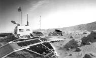
NASA scientists studied the Channeled Scablands in Fall 1995 to prepare for the Mars Pathfinder mission. (NASA Photo) |
Floods on Mars
Studies of early Martian history indicate that at one point the planet contained an abundance of water. The planet is covered with features that are best explained by the movement of water, either in catastrophic floods or by the slow movement of groundwater. The Mars Channels are thought to have been formed by catastrophic floods of water from massive groundwater reservoirs. The water would have flowed across the terrain, with the upper surface freezing and the lower depths continuing to flow, much as a frozen river might.
Researchers from NASA’s Jet Propulsion Laboratory (JPL), Arizona State University, and the Lunar and Planetary Institute in Houston studied the Channeled Scablands area of eastern Washington because it is similar to Ares Vallis, a region of Mars located northeast of the Valles Marineris canyon system. The Mars Pathfinder lander and rover, which landed on Mars in July 1997, set down in Ares Vallis. Pathfinder was the first spacecraft to land on Mars since the Viking Lander 1 touched down on the surface of the planet in 1976. Ares Vallis is much larger than the Channeled Scablands, but the landscapes of the two are very similar.
According to scientists at JPL, a catastrophic flood similar to the Missoula Floods occurred on Mars in the Ares Vallis flood channel, washing rocks and sediments from highland regions into the flood basin. Millions of years ago much of Mars was covered with water, and massive floods flattened some parts of the planet while other floods gouged seven-mile-deep canyons. Many planetary scientists theorize that the water on Mars drifted into space about 3.5 billion years ago. Some water also appears to have frozen on the planet’s surface, and some may have settled into the ground.
NASA researchers have investigated the spillover paleoflood channels connecting large basins in the northern plains of Mars. These channels are a series of braided channels approximately 500 km long and 130 km wide that connect the Elysium and Amazonis basins. Scientists even suggest that some of these floods were moving at speeds of up to 100 miles per hour, could have lasted for weeks or even months, and were considerably larger than the Ice Age Floods.
The floods on Mars were on such a monumental scale that they probably would have altered the climate for the entire planet.
Scientists don’t know exactly how the outflow channels on Mars were formed, and probably won’t until they can do fieldwork on the planet. By coming to the Channeled Scablands, they gained valuable firsthand exposure to the kind of surface features a rover was likely to encounter at Ares Vallis.

|
|
|
Islands of loess soil remain where the floods carved down to bedrock nearby. (NPS Photo) |
Rhythmites in the Walla Walla valley, Washington, with each layer representing an individual flood. (NPS Photo) |
Individual Floods Features
The rarity of the Ice Age Floods resources stems from the composite collection of Floods resources and their juxtaposition, rather than the rarity of a single feature. As part of the inventory process used in this study, Ice Age Floods resources across four states have been identified, located, and described. For example, within the Channeled Scablands of eastern and central Washington, some of the different types of Floods features or resources that can be found include erosional and depositional features such as:
Erosional
Depositional
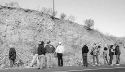
A Wilson Creek road offers a view of the composition of a longitudinal bar (M. Sear/Columbia Basin Herald). |
Taken individually, many of these features are not unique and would not be considered “rare.” But when combined with other features, such as entrapped lakes, giant current bars, flood strandlines, and spillways, the array of Flood features is evidence of an incredible series of events that are indeed rare and unique.
|
c o n c l u s i o n |
|
|
Because the Floods region records the greatest multiple flooding event documented in North America, has similarities with the Mars landscape, and has a unique combination of individual Floods features, it is safe to say the Ice Age Floods region has a high degree of “rarity.” |
Similar Resources Already Protected
Public Law 105-391 directs that the following factor be considered: “Similar resources already protected in the National Park System or in other public or private [emphasis added] ownership.” The majority of land within the Ice Age Floods region is privately owned. There are also specific Floods features that are protected by public ownership. Some private landowners are voluntarily protecting Floods features on their property. Because of the immense scale of the Floods region, the number of individual landowners runs into the thousands.
“My interpretations of the channeled scabland should stand or fall on the scabland phenomena themselves.”
J Harlen Bretz
Within the NPS, there are two areas in Wisconsin that relate directly to the last Ice Age: (1) the Ice Age National Scientific Reserve, and (2) the Ice Age National Scenic Trail. For the most part, the similarity ends with the words “Ice Age” in their titles.
The Ice Age National Scientific Reserve was set aside in 1964 to “assure protection, preservation, and interpretation of the nationally significant values of Wisconsin continental glaciation, including moraines, eskers, kames, kettleholes, drumlins, swamps, lakes and other reminders of the Ice Age.” The Ice Age National Scenic Trail was created in 1980 in an effort to connect the moraines as part of a system involving six of nine units of the Ice Age National Scientific Reserve. The moraines were evidence of the farthest advance of the last glacier in Wisconsin.

The floodwaters carved out more than 50 cubic miles of earth. House-sized boulders were bounced around as if they were pebbles. (J. Tindall, B. Pettus, J. Sipes) |
|

If the Floods occurred today, Portland, Oregon, would look like this, with 300 feet of water covering the city. (J. Tindall, B. Pettus, J. Sipes) |
There are many differences, but three main differences are obvious:
The Johnstown Flood National Memorial, in western Pennsylvania, commemorates the Johnstown Flood of 1889 which was caused by a break in the man-made South Fork Dam. The resulting flood caused the death of 2,209 people and injured thousands more in one of the worst disasters in our Nation’s history. The Johnstown Flood National Memorial commemorates a significant disaster resulting from the failure of a man-made dam. The Ice Age Floods region would commemorate a series of geologic events. The two areas have little in common from a resource standpoint. The similarity exists in the management approach where a collaborative public-private partnership is the key to a successful project.
The Ice Age Floods region covers more than 16,000 square miles and a linear distance of almost 600 miles across Montana, Idaho, Washington, and Oregon.
Interpretive Potential
The sheer magnitude of the Ice Age Floods offers a number of interpretive opportunities covering both geologic and cultural history of the Northwest. There are seven National Natural Landmarks (NNL) that form the framework of key interpretive Floods sites. Also, there are many Floods sites already on public land where there is little or no interpretation. If these sites and the NNL sites were linked as part of a coordinated interpretive approach along with other roadside interpretation, visitors to the Ice Age Floods region could gain a comprehensive understanding of this particular story of earth science.
The area could be publicized and local and regional Floods tour guides developed with assistance from local, county, and state tourism organizations and chambers of commerce. Because of its size the Floods region also lends itself to organized tours. The proposed coordinated interpretive efforts for the Ice Age Floods region would provide the visitor with a complete interpretive experience utilizing visitor centers, gateway communities to orient the visitors, roadside interpretive markers, guidebooks and brochures, audio-visual materials, and guided tours. Section J of this report covers how and where the interpretive effort should be directed.
|
c o n c l u s i o n |
|
|
Based on the geologic evaluations completed by the USGS and leading universities, and using the National Park Service Natural History themes, the various features and Floods Pathways of the Ice Age Floods region should be considered as highly suitable for consideration as a unit of the National Park System or for other national designation. A suitable management approach would be one that places emphasis on coordinated partnerships, is respective of the multitude of public and private ownerships, and is participatory in its approach. The addition of these Cultural History themes to the Natural History themes makes the Ice Age Floods region even more compelling and more clearly points to the exceptional degree to which this region qualifies for national recognition. However, it should be noted that the Floods region is not suitable for a national park or monument of more traditional designation. |
2. Feasibility
Traditionally, the National Park Service uses the term “feasibility” in much the same way as the private sector uses the term “cost effectiveness.” The two major questions are: (1) whether lands are configured in such a way as to allow for the protection of the land and its resources, and to provide for public uses, and (2) how much money it will take to operate the area. The answers to these two questions determine the feasibility of a project. Criteria for Parklands defines feasibility as follows:
To be feasible as a new unit of the National Park System an area’s natural systems and/or historic settings must be of sufficient size and appropriate configuration to ensure long-term protection of the resources and to accommodate public use. It must have potential for efficient administration at a reasonable cost. Important feasibility factors include landownership, acquisition costs, access, threats to the resource, and staff or development requirements.
Size and Configuration
The size of the Ice Age Floods region is sufficient to provide long-term protection of the resources and to accommodate public use. The “park without boundaries” concept focuses on using the resources found on existing publicly owned lands and along federal, state, and county roads for access. This approach negates the need for specific boundaries as seen in most proposals. Rather, the evidence of the Ice Age Floods pathways and its features determines the extent of the region. Public use can be accommodated on existing roads and trails, and visitor support facilities can be found in local communities located near or in proximity to the Floods Pathways.
The great gravel bar at Moses Coulee is more than three miles long and as high as a 30-story building.
Access
General access to Floods resources would be along existing federal, state, and local roads. In many cases, Floods resources can be seen from the highway or existing pullouts. In some cases, physical access to a Floods resource on private land could be restricted, but the resource could still be viewed from a distance. This would allow visual accessibility without compromising the rights of the property owner.
Threats to the Resources
Threats to resources in many NPS units pose significant concerns to planners and future managers. In many cases, the potential threat to smaller NPS units is considerably greater than with larger units simply because there are fewer features, and any impact may be considerable. The Ice Age Floods region, on the other hand, covers an immense area and includes hundreds of individual features such as gravel bars, ripple marks, and glacial erratics. In general, it is safe to assume that most large-scale scenic resources in the Floods region probably will not be greatly affected by human exploitation; however, this may not be the case for smaller-scaled features. Public agencies would be encouraged to protect Floods features on the land they manage. Floods resources on privately owned land cannot be protected without the landowner’s cooperation. Education of the public, including landowners with Floods resources, as to the value of the Floods resources is an important element of any interpretive program.
In some cases, gravel bars and similar resources have already been exploited, but the overall impact on the Floods resources is not significant. Smaller resources can be compromised by some landowners, but because of the large number of similar resources the overall effect is not significant.
Because none of the alternatives considered in this study depend upon the acquisition of private land for the success of the project, individual landowners retain all rights to use their land as they wish as permitted within existing local laws. Any arrangements between an individual landowner and local governments or private nonprofit land trusts would not fall within the purview of this study.
The loss of resources under the concept of this proposal is considered to be minimal.
Landownership
Although the majority of land within the Ice Age Floods region is in private ownership, many outstanding Floods resources are located on public land. In Montana many Floods resources are located on U.S. Forest Service land. Most of the Floods resources in Idaho are found on privately owned land, except for those found in Farragut State Park. The Floods resources in eastern Washington and the Channeled Scablands in central Washington are located on both publicly and privately owned land. Much of the public land is managed by either the Bureau of Land Management or the U.S. Fish and Wildlife Service. Public land areas include Sun Lakes-Dry Falls State Park, and the area around Lower Crab Creek, which is part of the Columbia National Wildlife Refuge. Floods resources in the Columbia Gorge are found in Oregon and Washington state parks, U.S. Forest Service lands, and private lands. Most lands within the Willamette Valley are privately owned, as are the lands along the lower Columbia River.
Acquisition Costs
No acquisition of privately owned land would be necessary to create an interpretive tour route for the Ice Age Floods region. Local governments may be interested in acquiring land for interpretive pullouts or additional parking for gaining better access to Floods features. In this situation, it would be the responsibility of the local government to work out an acceptable arrangement with the voluntary cooperation of a landowner. Public land managers would be encouraged to work together in an effort to protect and interpret the Ice Age Floods resources on the lands they administer.
Staff or Development Requirements
Requirements for staffing and development vary depending upon the management option implemented for the Floods region (see Section L Management Options). The alternatives for management, with one exception, examine the creation of a cooperative management structure with public funding for a support staff. An example of this structure can be seen in the New Jersey Coastal Heritage Trail, where the National Park Service assists a Commission by funding the operations of a support staff. The use of volunteers and the cooperation of nonprofit organizations can greatly reduce staffing costs.
Costs for developing new interpretive facilities and pullouts, or improving those that currently exist, are considered to be capital costs or investment costs. Funding can be obtained by a combination of approaches, including federal and state highway funds such as Transportation Efficiency Act Twenty-First Century (TEA-21) funds, grant programs, matching grant programs, and an initial start-up program funded by private sector foundation support in the authorizing legislation.
|
c o n c l u s i o n |
|
|
Given the number of public roads and highways following the Floods Pathways and the extent of Floods features that can be found on public lands within the region, it is feasible to interpret the Ice Age Floods across four states. But the degree of feasibility increases proportionately to the level of participation of local, state, tribal, and federal governments, and broad participation by interested citizens from throughout the region. The key to developing a cohesive approach to the Ice Age Floods is cooperative “ownership” of the joint management concept. All levels of government, as well as the private sector, stand to benefit in numerous ways from the creation of an Ice Age Floods interpretive tour route along flood pathways. |
|
|
|
|
Source Lake and Temporary Ponds During Floods |
|
Lake |
Maximum size |
Glacial Lake Missoula |
2,900 |
Southern Washington |
|
Pasco & Quincy Basins |
2,050 |
Walla Walla Basin |
330 |
Lower Snake River |
300 |
Above the Gorge |
|
Umatilla Basin |
1,300 |
Intermediate and tributaries |
150 |
The Dalles Basin |
100 |
Willamette Valley |
3,000 |
Total |
10,710 |
|
|
|
|
|
|
|
Approximate Depth Of Water Over Present-Day Areas |
|
City or Place |
Depth |
Missoula, Montana |
950ft |
Spokane, Washington |
500 |
Yakima, Washington |
200 |
Richland, Pasco, & Kennewick, Washington |
900 |
Umatilla, Oregon |
1000 |
The Dalles, Oregon |
1000 |
Hood River, Oregon |
900 |
Crown Point, Oregon |
700 |
Portland, Oregon |
300 |
Willamette Valley, Oregon |
300 |
Woodland, Washington |
300 |
Kelso & Longview, Washington |
200 |
Astoria, Oregon |
Present day sea level |
|
|
|
|
|