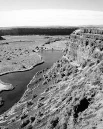
The floods carved out more than 50 cubic miles of earth from western Montana to the Pacific Ocean. (NPS Photo)
Ice Age Floods |
|
s u m m a r y |
|
|
The Floods region is reviewed to determine if it meets NPS requirements for “national significance,” and if the resources within the area are threatened in any way. Level of National Significance is established in part by examining NPS “service themes,” which look at both natural and historic themes. Based upon these criteria, the Floods region exceeds the basic requirements for consideration. |
1. National Significance
An examination of resources for their national significance is the first step in the study process. The Criteria for Parklands, a National Park Service publication, lists the qualifications used for screening proposals for new park units to assure that only the most outstanding resources are added to the National Park System.
NPS applies ten specific standards to determine national significance. The Ice Age Floods study region meets four of these standards:
The Criteria for Parklands also includes examples of the types of characteristics that would help define an area or region as being truly unique and worthy of consideration. Four resource evaluations examples listed apply directly to the Ice Age Floods region:
There are seven National Natural Landmarks (NNLs) located within the Ice Age Floods region. A National Natural Landmark is a nationally significant area that has been designated by the Secretary of the Interior. To be nationally significant, a site must be one of the best examples of a type of biotic community or geologic feature in its physiographic province. The Floods-related NNLs are:
Awesome signs of its passage are still visible to this day.
Smithsonian Magazine, The Floods that Carved the West, April 1995.
|
|
|
The floods carved out more than 50 cubic miles of earth from western Montana to the Pacific Ocean. (NPS Photo) |

|
|
|
Highest Velocity of the Flood Waters Along the entire flood route between Glacial Lake Missoula and the Pacific Ocean, the great floods spread out over wide areas and then funneled through constrictions. The narrowest constriction of all was near Crown Point in the Columbia River Gorge, where all 500 cubic miles of water were forced between tall cliffs only 1.5 miles apart. Like a jet of water exiting a nozzle, the flow accelerated from the narrow opening, probably reaching speeds of 80 miles an hour before slowing and spreading out over the Portland Basin. |
|

|
The finest examples of these giant flood ripples are found 12 miles north of Perma, Montana. The giant ripples appear as ridges 15 to 50 feet high, 100 to 250 feet wide and from 100 yards to a half mile long. They generally traverse the direction of the current. The form, structure, and arrangement of these features are similar to those of ordinary current ripple marks, but the features are so large that the term “ripple mark” seems inappropriate. It is believed that the giant ripple marks could only have been formed by water at least 800 feet deep, moving over Markle Pass at velocities up to 55 miles per hour.
The national significance of these seven NNLs has already been established, and with the addition of a multitude of other Floods-related resources, combine to make the Ice Age Floods region a spectacular assemblage of Floods resources that exceed the requirements for recognition of a nationally significant resource.
|
c o n c l u s i o n |
|
|
Based upon the requirements established in the NPS Criteria for Parklands, the Ice Age Floods region exceeds the basic requirements for consideration under the criteria for national significance. These Floods are the greatest scientifically documented floods known to have occurred in North America and are one of three documented geologic areas in the world that experienced catastrophic Ice Age floods of a similar magnitude. In addition, NASA intensely studied the Channeled Scablands for comparisons to similar catastrophic flooding that scientists believe occurred on the planet Mars. |
2. Integrity
|
|
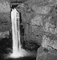
Palouse Falls State Park, Washington (NPS Photo) |
|
|
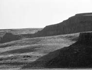
Moses Coulee gravel bar, Douglas County, Washington (NPS Photo) |
The term “integrity” has two definitions, both of which are closely related. The first refers to a state or quality of being complete, and the second addresses the quality of being unimpaired or unmarred. One interesting feature of the Ice Age Floods resources is the fact that many Flood resources are still visible and have not been damaged by human development or natural processes over more than 13,000 years. The existing Floods resources captured the interest of Pardee and Bretz, who were able to develop their theories from the things that they could see. The huge scale of the Ice Age Floods region helps in preserving the integrity of the resource; most changes seem minor when considering the enormity of the region and the sheer size of individual features. The immensity of the ripple marks in Camas Prairie, Montana, the width of Dry Falls, and depth of the plunge pools, and 800-foot flood strandlines that are still visible all contribute to exceptional integrity of the Ice Age Floods resources. A number of Floods resources are virtually untouched, and many are so resistant to change that even large-scale mining operations have not had much impact.
The fact that several Floods features are within protective management on public lands helps ensure the integrity of the resources. Some private landowners also protect Flood features on their property through voluntary stewardship. Some of these features are designated as National Natural Landmark sites.
Driving through the landscape, a motorist familiar with the story of the Floods and with a knowledge of specific types of Floods features can’t help but notice the evidence left behind. This evidence is much the same as it was when Bretz and Pardee made their discoveries.
|
c o n c l u s i o n |
|
|
The Ice Age Floods resources, the majority of which have been largely unchanged for thousands of years, possess a very high degree of “integrity” and meet the requirements of PL 105391. |
|
|