
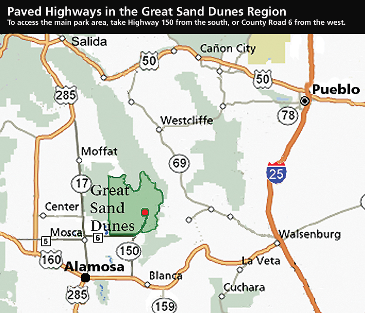
To access the main park area, including the Dunes Parking Lot, Visitor Center, and Pinon Flats Campground, take Highway 150 from the south or County Road 6 from the west. Both are paved highways. View area map larger. DO NOT USE COMPUTER MAPPING PROGRAMS IN THE ROCKY MOUNTAINS FOR HIGHWAY TRAVEL. The most commonly used mapping programs have directed visitors to drive over hiking trails or primitive 4WD roads to reach the park. Numerous visitors have become stranded in snow or stuck at a remote trailhead trying to use GPS to reach the main park area. Use the area map shown, or any Colorado highway map. By car: From Denver, Colorado Springs, or Pueblo, the most common route is south on I-25 to Walsenburg, west on US 160, north on State Highway 150. For a more mountainous drive from Denver (same mileage as the I-25 route), you may also take US 285 south, then State Highway 17 south, then County Lane 6 east from Mosca. From Albuquerque, drive north on I-25 to Santa Fe, then north on US 285 to Alamosa. From Alamosa, take either U.S. Highway 160 east and State Highway 150 north, or State Highway 17 north and County Lane 6 east from Mosca. Driving mileages to Great Sand Dunes Visitor Center from: Alamosa: 37 By car from Westcliffe/Wet Mountain Valley to Great Sand Dunes Visitor Center (shortcut over Pass Creek Pass, dirt road open year round for passenger cars): - Travel Southeast from Westcliffe on Highway 69 toward Gardner, approximately 30 miles - Turn West (right) on 550 RD, just before Gardner; drive approximately 6 miles - Turn South (left) onto 570 RD (turns into 572, then 29 RD), look for small sign to "PassCreekPass"; drive approx 12 miles - Turn West (right) on US Highway 160 - Turn North (right) on State Highway 150 By car from Great Sand Dunes Visitor Center to Westcliffe/Wet Mountain Valley (shortcut over Pass Creek Pass, dirt road open year round for passenger cars): - South on State Highway 150 - East on US Highway 160 - North (left) onto Pass Creek Pass Road (look for sign two miles west of La Veta Pass (starts as 29 RD, turns into 572 RD). The Pass Creek road goes uphill for one mile, then downhill for 11 miles. - When you arrive at a T intersection with a paved road, turn East (right) onto 550 RD toward Gardner; drive approx 6 miles - Turn West (left) onto Highway 69 toward Westcliffe, approximately 30 miles By air: Commercial air service is available to a small airport at Alamosa, Colorado, 38 miles from Great Sand Dunes. Colorado Springs, Denver, and Albuquerque are served by many commercial airlines. Rental cars are available at all these airports. |

Last updated: February 7, 2025