
NPS Glacier's weather is highly variable and can be extreme. In winter, most of the park is covered in several feet of snow, and there are many cloudy, snowy days. In spring, rainy days and cooler temperatures are common, even throughout the month of June. Hot days and cool nights are normal throughout July and August. Hikers setting out on a warm summer day should expect changing conditions and bring rain gear and extra layers of clothing. In fall, temperatures begin cooling down, and snow may occur even at lower elevations as early as mid-September. Packing extra layers is the key to a comfortable visit regardless of season. ForecastsFor a current weather forecast of the entire park, please check Today's Forecast. More detailed forecasts can be found at West Glacier and St. Mary. For information on air quality in the park and surrounding region, please visit the Montana Department of Environmental Quality website.
Temperature & Precipitation AveragesBelow are average temperatures and precipitation numbers for West Glacier, Montana, which sits at around 3,200 feet (975 m) in elevation. The east side of the park is higher in elevation and often experiences cooler temperatures and stronger winds. 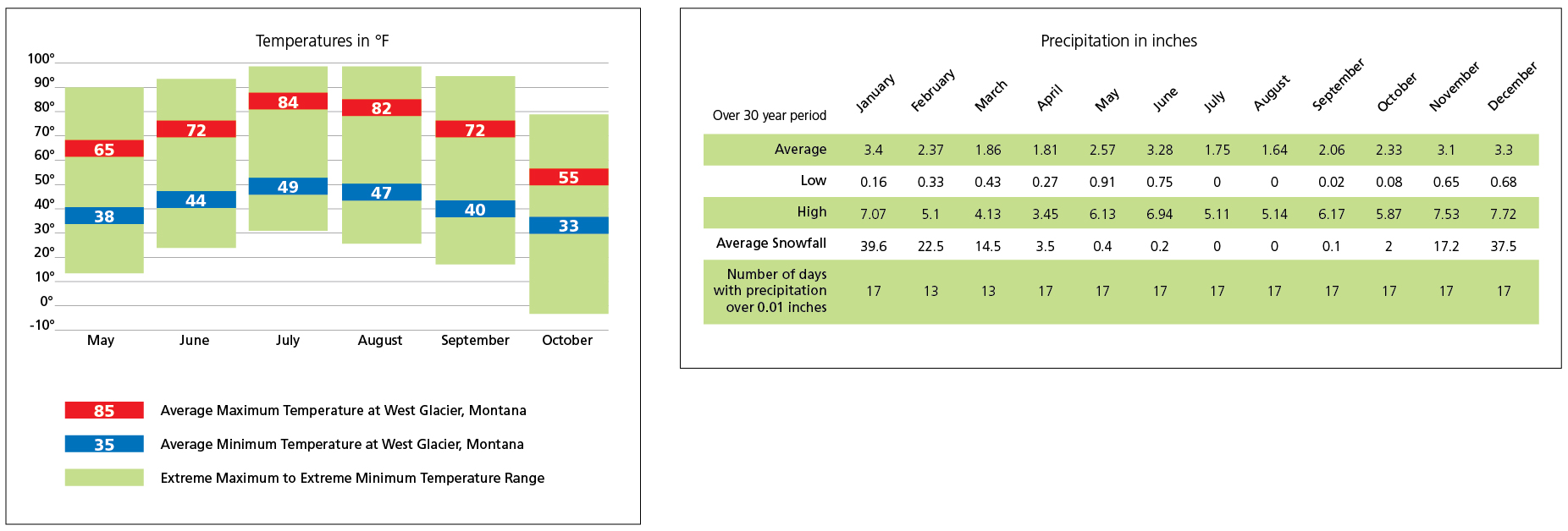
NPS Graphic It is generally 10 to 15 ºF cooler at higher elevations, such as at Logan Pass. Overnight lows throughout the park can drop to freezing, and snow might occur at any time of the year. The Continental DivideThe park straddles the Continental Divide, separating two very different climate zones on each side. Warm, wet Pacific air moves in from the west, with cold, dry Arctic air from the northeast, and the two meet at the Divide. Weather conditions on the west side of the park can thus be drastically different from conditions on the east side on a daily basis. Western valleys generally receive the most rainfall, but daytime temperatures can easily exceed 90 ºF. Strong winds, sunny days, and cooler temperatures are common on the east side. PrecipitationIn the driest corners of the park, along the northeast and northwest edges, rainfall averages 23 inches (58.4 cm) a year, while the lowlands of the west side receive about 30 inches (76.2 cm) of precipitation on average. Since moisture-laden air is forced up to high elevations at the Continental Divide and cools, the annual precipitation average jumps to 100 inches (2.5 m) or more in isolated mountain cirques. Snowfall settles to around a 16-foot (4.9 m) average snowpack. Early summer snow removal on Going-to-the-Sun Road takes months to complete (see the park’s Flickr album of the process). The east side gets less overall precipitation and is prone to high winds. Downslope gusts are often 50 mph or more, sometimes reaching 100 mph. Winter chinook ("snow-eater") winds regularly create a temporary spring, raising temperatures over 30 ºF in just minutes. If cold Arctic air pools deep enough on the east side to spill over the Divide and collide with Pacific moisture, raging blizzards can result. One dumped 44 inches (1.1 m) of snow in a single day. Climate ChangeLandmark scientific research on the effects of global climate change is currently ongoing in this mountain ecosystem. The park’s receding glaciers provide a revealing glimpse into how the warming climate is impacting our ecosystems and the world overall. While precipitation changes are more difficult to predict than shifts in temperature, scientists expect to see increasingly more precipitation fall here as rain (rather than as snow). This means alpine snowpack will continue to decrease in the future. With lower precipitation rates and less winter accumulation, the park’s remaining glaciers will continue to melt away. |
Last updated: November 4, 2021