Unit 6: Upper Teklanika River

UNIT 6
UPPER TEKLANIKA RIVER
Quota: 6
USGS Quad Maps: Healy C6, Healy B6, Healy C5, Healy B5

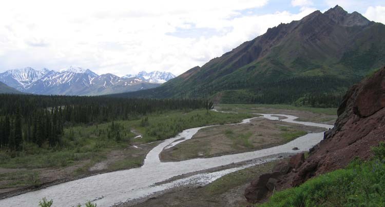
Description: The northern part of this unit contains rolling hills and dwarf birch shrubland. The midsection of the unit includes Cathedral Mountain on the west side of Teklanika River and Double Mountain on the east. Cathedral Mountain is made up of many small alpine valleys with interconnecting passes. The southern end of the unit is the headwaters of the Teklanika River and the large glacier basins that feed it. The wide, open hillsides and ridges of the headwaters are covered with dry tundra.
 
a river running through forest, past a tall mountain, other mountains in the distance
Looking south into the Teklanika River drainage, with Cathedral Mountain on the right.

NPS Photo


Tips and Special Features
The combination of a relatively short bus ride and abundant alpine terrain makes a trip into this unit a good way to sample the landscape that is typical of the central and western portions of the Park Road corridor. Consequently, it is a popular unit and fills regularly during the summer season. The numerous interconnected drainages on Cathedral Mountain provide many opportunities for short, easy hikes into alpine terrain.


Access
Primary access points are from the Teklanika Rest Stop, Igloo Campground, Teklanika River Bridge and anywhere along Cathedral Mountain. This area can be reached by a 1 – 1.5 hour bus ride.


Common Routes and Hiking Corridors
Unit 6 is large and diverse; parties can spend from one to seven nights and not run out of things to see and do. The low ridge systems east of the Teklanika Campground and Teklanika River Bridge can be used as routes to cross over into the middle part of the Sanctuary River (Unit 5) or for a quick overnight trip. A tempting access point for trips south is the Teklanika River Bridge on the Park Road. However, there is frequently a seasonal wildlife closure here that encompasses the entire area south of the bridge to Double Mountain - making travel here illegal. A good alternative to avoid the closure is to begin on the south side of the Igloo Creek Bridge (just past Igloo Creek Campground) and hike east to the river. The hike to the river is through spruce forests and wet tundra.

For short overnight trips or day hikes, there are a number of drainages leading from the Park Road up into Cathedral Mountain. At nearly 5,000 feet and with multiple summits, Cathedral Mountain has high tundra, scree slopes, and a multitude of ridges and nooks to explore. Traveling around the south side of Cathedral Mountain is another good way to reach the major travel corridor of the Teklanika River.

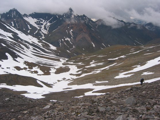
The Teklanika River is a wide, open gravel bar and the stream is well-braided from its headwaters to the confluence with Calico Creek (about 3.5 miles south from Igloo Campground). The river is generally crossable (except during major rain events) south of Calico Creek. All summer, crossings north of Calico Creek are far more difficult and sometimes impossible on foot. Traveling downstream on the east side of the Teklanika River north of Calico Creek is not recommended as there are few crossings to get you back to the Park Road. The steep and rocky pass at the headwaters of Calico Creek is a way to drop into the Upper Sanctuary River (Unit 5). Important information about the east side of this pass is provided in the Unit 5 description.
 
mountains covered at the top by thick clouds, with patches of snow and a person, dwarfed in the scenery, hiking among rocks
A pass in Upper Calico Creek leads east into the Sanctuary River basin (Unit 5).

nps photo


There are many opportunities for multi-day hikes in the southern headwaters of the Teklanika. All the major tributaries contain glaciers that are rapidly retreating, leaving behind piles of glacial moraine. The glaciers at the Teklanika headwaters offer a unique destination since none of them can be seen from the Park Road. These tributaries are surrounded by miles of open tundra hillsides and steep mountains. It is about 12 miles from Igloo Campground to the scenic headwaters of the Teklanika. There is one more major pass that leads east from this headwaters area into the Sanctuary River valley (Unit 5). It is very steep scree and more difficult than the pass over Calico Creek. It can be covered with steep, unstable snow fields into July, particularly on the east side.

It is also possible to get off the bus on the south side of Cathedral Mountain and travel on the high ridgeline between Unit 6 and the Upper East Fork drainage (Unit 7). If you try to camp on this ridge, it can be difficult to find a spot out of sight of the road.


Additional Notes and Hazards
There are usually wildlife closures in this unit, so make sure you have the closures accurately marked on your map before heading out. It is your responsibility to stay out of the closures while in the backcountry.

Last updated: April 14, 2015

Park footer

Contact Info

Mailing Address:

PO Box 9
Denali Park, AK 99755

Phone:

907 683-9532
A ranger is available 9 am to 4 pm daily (except on major holidays). If you reach the voicemail, please leave a message and we'll call you back as soon as we finish with the previous caller.

Contact Us