|
October 2025 Update: The construction crews made momentous progress this season! In late July, they successfully launched the bridge over to the west side and lowered it onto the west abutment in early-Sept. By the end of September, much of the bridge decking had been installed as well. That means we're still on track for a mid-summer 2026 project completion, which will allow NPS to use the remainder of next season to work on any necessary repairs to the western half of the Park Road and take care of deferred maintenance of west district facilities. We expect the full length of the road to be open and full bus services to resume in 2027. Until then, visitors will still be able to take a transit or tour bus out to the East Fork area at Mile 43 between May 20 and September 17, 2026. The Pretty Rocks Construction blog is paused for the winter, but look through old posts for photos and details on past progress. Check the current conditions of the Park Road and visitor services. 
NPS Photo BackgroundThe Pretty Rocks Landslide (mile 45.4) has been slowly displacing a portion of the Denali Park Road near Polychrome for decades but when the movement suddenly intensified in late summer 2021—from inches per day to inches per hour—safe passage through the area became impossible, forcing the immediate closure of the road and cutting off vehicle access to popular visitor destinations and facilities including Polychrome Overlook, Toklat, Eielson Visitor Center, and Wonder Lake. Additional hazards with the potential to cause further damage to the road in the Polychrome area were also identified such as the Perlite Landslide (mile 45.3) and the Bear Cave Landslide (mile 44.8). Due to the continuing road closure, buses can travel no farther than mile 43 of the 92-mile Park Road and access to Kantishna is only by air. Read more about the science and monitoring of the Pretty Rocks Landslide and other geologic hazards. 
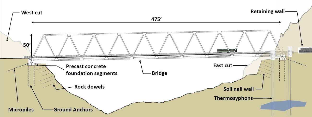
Photo courtesy of BGC Engineering Project OverviewThe Federal Highways Administration (FHWA), in collaboration with the National Park Service (NPS), developed the Polychrome Area Improvements plan to restore reliable road access west of Pretty Rocks. The plan addresses several geologic hazards in the Polychrome area (Mile 44–46) that threaten public safety and infrastructure and includes two construction phases: construction of a bridge to span the Pretty Rocks Landslide at Mile 45.4 (Phase I) and road improvements near the Bear Cave Landslide at Mile 44.8 (Phase II). Funding for the project was secured through a combination of Bipartisan Infrastructure Law dollars, additional Federal Lands Transportation Fund dollars, and 2023 Disaster Relief Supplement funding. The construction contract was awarded in January 2023 and work on Phase I began in Summer 2023; Phase II will begin in Summer 2026. 
Source: NPS and Jacobs Engineering Phase I Includes:

Source: NPS Phase II includes:
NEPA and NHPA ComplianceThe National Environmental Policy Act (NEPA) mandates an environmental assessment of any proposed federal action that has the potential to “significantly affect the quality of the human environment." Section 106 of the National Historic Preservation Act (NHPA) requires that federal agencies identify and assess the effects its actions may have on historic properties and consider public views and concerns about historic preservation issues when making final project decisions. Compliance with the NHPA is conducted concurrent with, but as a separate process to, the NEPA compliance process. Environmental and cultural compliance for the Polychrome Area Improvements project was formally initiated in October 2021 and was completed in March 2022:
The NPS contracted an environmental consulting firm (AECOM) to prepare the Environmental Assessment (EA), which considered the environmental consequences of a “no action alternative” (no new bridge and the road remains closed) and an “action alternative” (construct Pretty Rocks Bridge and Polychrome Road Improvements). Prior to the development of the EA, the NPS consulted with federally recognized Tribes, Alaska Native Corporations, State and local governments, and the State Historic Preservation Office. The NPS also hosted two virtual public meetings in October 2021 to identify and document specific concerns, issues, and potential impacts of both alternatives. Issue topics analyzed in the EA included geology, socioeconomics, visual resources, visitor use and experience, noise / soundscape, wildlife, wetlands and vegetation, cultural resources, and wilderness. Following the publication of the EA in January 2022, two additional virtual public meetings were held to discuss the analysis and provide information to aid the public in reviewing and commenting on the compliance document. After careful consideration of resource impacts, consultation with stakeholders, and review of public comments, the NPS concluded that the Polychrome Area Improvements project would not have a significant effect on the environment. The Finding of No Significant Impact (FONSI) was approved by the NPS Alaska Regional Director and released to the public in March 2022. Subsequent updates to the project were also reviewed and determined to have little or no potential for additional environmental impacts and therefore were categorically excluded (CE) from further analysis. Those CEs are documented separately: Phase I design changes (2023), changes to staging and project areas (2023), and Phase II revised plan (2025). How Can I Get Involved?Learn about other plans and become familiar with the Denali Planning Portfolio. Check the NPS Planning, Environment, and Public Comment (PEPC) website for documents available for review and comment. |
Last updated: November 18, 2025
