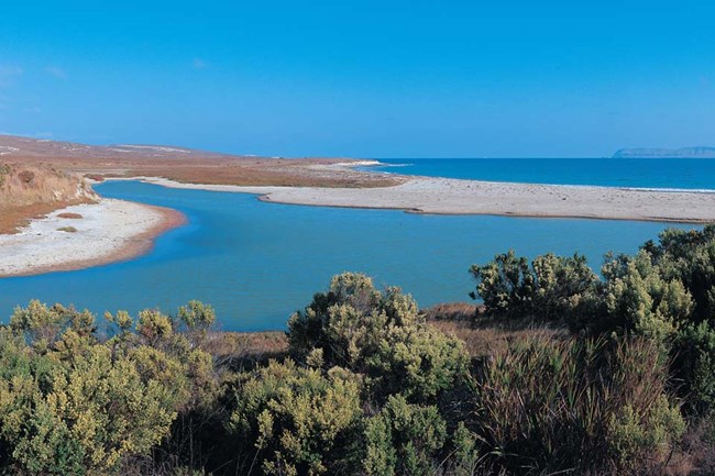
Floodplains By allowing fast-flowing water to spread out and slow down, floodplains help sediment and pollutants settle out, and reduce the frequency and severity of floods. Floodplain vegetation also catches moving sediment, absorbs excess nutrients, and provides a place for fish, birds and other wildlife to find food and shelter. Though most of the islands' floodplains are restricted to just the lower reaches of coastal streams, some are quite extensive, including those along Scorpion Creek and in the lower parts of Cañada del Puerto on Santa Cruz and Old Ranch Creek on Santa Rosa Island.
The Scorpion Creek floodplain stretches across the entire lower valley, but the whole creek channel is often realigned by the particular nature of its hydrology and sediment deposition processes. This creates a unique set of challenges for park managers, as all of the site's facilities and historic structures are in the stream channel or the floodplain. Former occupants addressed this issue by lowering and enlarging the channel. Though the National Park Service has also done some channel excavation, the dynamic nature of this system means that flooding will always be a potential hazard here. The Cañada del Puerto floodplain covers much of Prisoners Harbor. Upstream where the creek emerges, steep, highly erodible hillsides wash enough sediment into the stream to exacerbate flooding and periodically change the stream's course. Fortunately, though it shares some of the same dynamic characteristics as the Scorpion Creek floodplain, there are far fewer park structures here to worry about.
Wetlands Located at the fringes of where water meets land, wetlands provide food and refuge for a myriad of species. Like floodplains, they also slow down flowing water, reduce flooding, capture sediment and pollutants, and help recharge groundwater. Though once thought of as "wastelands" to be drained and developed, the ecological and economic values of wetlands have become more widely recognized in recent years. Santa Cruz, Santa Rosa, and San Miguel Islands each have several different kinds of wetlands. (For more details about the different kinds and classifications of wetlands see the US Geological Survey's website). Coastal salt marshes are found in the upper intertidal areas of protected shallow bays, estuaries, and lagoons. There are also wetlands at the mouths of several of Santa Cruz Island's canyons, including Prisoner's Harbor, Cañada de los Sauces, Cañada de Malva Real, and Scorpion Canyon. Because they are situated near the coast, these wetlands are shaped by the tides and by their connection to the ocean, which changes with the seasons. Three contiguous kinds of wetlands grace the shores and slopes near the mouth of Scorpion Creek. The harsh conditions found in the marine intertidal wetlands along the rocky shoreline leave them largely bereft of vegetation. Above the shoreline lie estuarine intertidal emergent wetlands, which are irregularly flooded, as the natural cobble berm along the shoreline sometimes disrupts the exchange of fresh and salt water. Salt water trapped behind the berm and long, dry summers have created conditions that foster a unique plant assemblage, including saltgrass, Frankenia, sea-blite, sandy-spurry, California, Coulter's, and Brewer's saltbush, and alkali weed-a species common in this area that is rare elsewhere on the island and in California. The third wetland area in and near the stream channel is classified as riverine /lower perennial/rock bottom, and has little or no vegetation due to harsh scouring and heavy sedimentation. Centuries of human use have dramatically changed Scorpion Creek's wetlands. About 75% of the lower floodplain's riparian and wetland areas have been dredged, graded, or filled to create pastures. Feral sheep that once lived here wreaked havoc by grazing and trampling the site's plants and soils. Wetland vegetation has come back and the hydrology has dramatically improved since the sheep were removed in 1999. Prisoners Harbor, at the mouth of Cañada del Puerto on Santa Cruz Island was home to the largest coastal wetland on the Channel Islands until the 19th century when it became the island's main port and center of agriculture and industry. The island's landowners eliminated about 60% of the wetlands by rerouting and channelizing the creeks and filling the wetlands with gravel from the surrounding hills and creek bed. They also planted non-native eucalyptus trees, which quickly spread through the valley. These trees have replaced native vegetation and draw moisture from the creek and groundwater that would normally go to feed the wetlands. Today, three main types of wetlands still exist at Prisoner's Harbor, though they are not the same kinds as were there a hundred years ago. Two of the three: the rocky intertidal marine wetlands and the riverine/lower perennial/rock bottom wetlands, have little or no vegetation. In contrast, Prisoners Harbor's three different types of palustrine wetlands, are predominantly populated by native willow, bulrush, and cattail, and also sticky baccharis, saltgrass, arroyo willow, mulefat, arrowweed, and water parsnip, as well a number of non-native species. In 2011, the National Park Service and the Nature Conservancy began to restore nearly 60 acres at Prisoners Harbor, including about four acres of coastal wetlands and nearly one mile of stream habitat. Taking care to protect and remove archeological and historical resources at the site, they removed fill from the wetland and reshaped the landscape to what it once was. They also removed a 250-foot artificial berm, which allowed the wetland to flood naturally. Non-native species including the eucalyptus trees were removed and replaced with native riparian and woodland species. The restoration of a functional wetland and associated habitats will directly benefit woodland birds, migratory waterfowl, amphibians like Pacific tree frogs and salamanders. It will also have a ripple effect throughout the food chain and help other native animals like Santa Cruz Island fox. More details about this restoration project are available at Park Management. |
Last updated: June 21, 2016
