|
You are viewing ARCHIVED content published online before January 20, 2025.
Please note that this content is NOT UPDATED, and links may not work. For current information,
visit https://www.nps.gov/aboutus/news/index.htm.
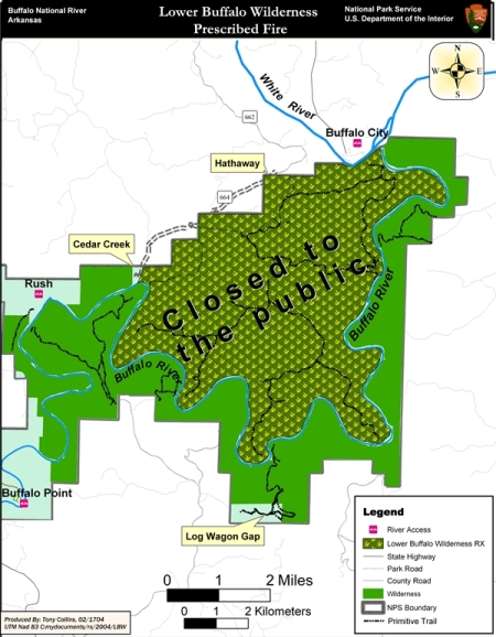
Contact: Fenn Wimberly, 870/365-2772 From March 1st - 31st, Buffalo National River will conduct a controlled burn inside the Lower Buffalo Wilderness area. The 11,284 acre Lower Buffalo Wilderness Prescribed Fire unit is located in southeast Marion County approximately 7 miles southeast of Flippin. The entire unit is expected to require less than 30 days to actually ignite, but to ensure safety; the area will be closed to the public for the entire period. One of the purposes for conducting a prescribed burn is to reduce the hazardous fuels that could possibly lead to catastrophic wildfires, but there are a myriad of other benefits. For example, prescribed burns promote the restoration of post oak savannas and cedar glades areas, as well as lowers the risk potential of various forest diseases. Also, prescribed burns improve wildlife habitat and diversity. Closing will occur on the north side of the Buffalo River inside the Lower Buffalo Wilderness. The boundary of the closed area follows a line from the White River along the Buffalo River upstream to the west and north to Cedar Creek access; then east along the park boundary to the White River; and then south downstream along the White River to the Buffalo River. Cedar Creek access will be closed only during periods of actual burn operations. The river corridor will not close at any time. Canoes and john boats will continue to have river access while camping will be allowed on gravel bars. Arkansas Game and Fish Commission, United State Forest Service, Arkansas Forestry Commission, and Rea Valley Volunteer Fire Department will assist with the burn. |
Last updated: April 10, 2015