|
You are viewing ARCHIVED content published online before January 20, 2025.
Please note that this content is NOT UPDATED, and links may not work. For current information,
visit https://www.nps.gov/aboutus/news/index.htm.
NPS photo
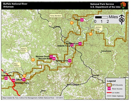
Contact: Caven Clark, 870-365-2790 The active fire situation in the lower half of Buffalo National River appears to be slowing down at present. All four fires are 100% contained with the smaller ones burned out. Monitoring is continuing as needed to insure that there are no flare-ups and wind-driven surprises. As of this release, over 800 person-hours have been dedicated to responding to these fires. The "Jackson Ridge" fire in the Lower Buffalo Wilderness (Marion County) is 100% contained with a final control size (area within containment zone that will be permitted to burn out) of 1300 acres. This fire will continue to burn in stumps, and in down and dead fuels, for several days. In total, twelve persons were assigned to this fire with crews from NPS, Arkansas Game and Fish Commission, and USFS –Sylamore District Ozark NF. Yesterday (1/20) two firefighters were assigned to monitor and patrol the fire for the next several days. Today's control objectives are to strengthen the control line at Ludlow Gap (the neck of the "duckhead"), continue to burn out pockets of unburned fuel to reduce the risk of spot fires do to the wind and low humidity over the next several days. Fire operations will continue for several days using similar tactics. The closure remains in effect at this time. Cause remains under investigation. The "Baker's Dozen" wildfire on Tomahawk Creek near Gilbert (Searcy County) is 100 % contained with a final number of 80 acres involved. This fire was caused by escaped debris burning on private land. Response included Arkansas Forestry Commission, NPS, and Pindall, Gilbert, and St Joe Rural Fire Department. It was contained at 10 pm 01/18/2015 using a combination of dozer, hand line and the creek. The "Gobblers' Knob Private Rx" fire was initially responded to by Pindall, Gilbert, and St Joe Rural Fire Department and Marshall fire resources near Silver Hill on Highway 65. NPS staff located the fire at the end of Zack Ridge Road. Searcy County then reported the fire to be a controlled burn on private lands. This "controlled burn" continues to burn throughout the area. All though the burn is approaching the NPS boundary it is not on NPS lands at this time. The fire will be monitored by NPS staff on a daily basis but no action will be taken until it crosses into NPS lands, based upon fire behavior and fuels the fire poses a minimal threat to NPS lands at this time. The "Blue Ribbon Road" wildfire threatened structures including one NPS house currently unutilized and a private farm house, out buildings, farm equipment, and livestock. This fire was reported 100% contained with a total involvement of about 693 acres. Resources for this fire included the United States Forest Service, the Pindall, St Joe, Gilbert Rural Fire Department, Arkansas Forestry Commission, and the Searcy County Sherriff's Office. Cause of fire is unknown at this time and is under review by the NPS and Arkansas Forestry Commission. The "Tony Bend" wildfire (Marion County) was declared 100% contained yesterday afternoon.The initial attackMondaywas a cooperative effort with Ralph Caney RFD, Arkansas Forestry Commission, and NPS resources. Threats included private residences, the historic town of Rush, and several NPS buildings, and a portion of the Lower Buffalo Wilderness area. Estimated 175 acres affected including a mix of private and NPS lands. NPS fire staff will continue to monitor and check control lines today. Crews will search for spot fires on NPS ands today that may have occurred in the wilderness. Interior islands of dead fuel and leaf litter will likely continue to burn for several days. NPS staff will continue to monitor until fire is out, since it remains a viable threat to NPS wilderness, and NPS facilities. No precipitation fell over the area last night nor is there any in the forecast for the next five days. As it stands, all known fires are under control and monitoring taking place as necessary. There is little prospect in a lessening of fire danger so visitors and landowners are once again encouraged to exercise extreme caution in their use of fire. |
Last updated: April 10, 2015