National Park Service LogoU.S. Department of the InteriorNational Park ServiceNational Park Service
National Park Service:  U.S. Department of the InteriorNational Park Service Arrowhead
Bryce Canyon National Park Looking through a tunnel along the Peek-a-boo trail
view map
text size: largest larger normal
printer friendly
Bryce Canyon National Park
Right Fork Swamp Canyon Campsite

This site is easy to get to. It is 1.1 miles (1.8 km) from the Sheep Creek Swamp Canyon parking lot, down the Swamp Canyon Connecting Trail. It is just to the north of the junction of the Swamp Canyon Connector and the Under the Rim Trail. There are three big Ponderosa Pine at the site with lots of Gambel Oak and some Alderleaf and Curlleaf Mountain Mahogany. There is no water at the site. There is water about .5 mile (.8 km) up the Swamp Canyon Connector, just to the south of the trail. There are views of the cliffs and Swamp Canyon Butte near the site.

Datum WGS 84, 37 34 36.8 N, 112 12 46.3 W Altitude 7515 feet (2291 m).

 
Right Fork Swamp Canyon campsite and view of red cliff butte.
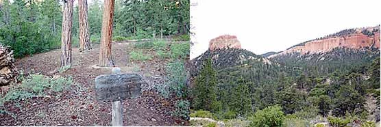
text and images courtesy of Ron Warner
Right Fork Swamp Canyon campsite and view of red cliff butte

You are exiting the National Park Service website

Thank you for visiting our site.

You will now be redirected to:

We hope your visit was informative and enjoyable.

Utah Prairie Dog

Did You Know?
Utah Prairie Dogs are a threatened species found only in southwestern Utah. Distinguishable by its white tail and black eyebrows, several colonies are located within Bryce Canyon's boundaries.
more...

Last Updated: November 30, 2006 at 18:08 MST