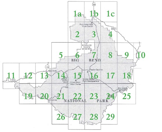
Maps in the USGS 7.5 minute series are highly encouraged for most backcountry use in Big Bend. They have a scale of 1:24,000 and a contour interval of 40.
It takes thirty-one maps to cover the area of the park:
1a Butterbowl
1b Persimmon Gap
1c Bone Spring NE
2 Twin Peaks
3 Bone Spring
4 Dagger Flat
5 Christmas Peaks
6 Sombrero Peaks |
7 Grapevine Hills
8 McKinney Springs
9 Sue Peaks
10 Stillwell Crossing
11 Lajitas
12 Amarilla Mtn.
13 Terlingua
14 Tule Mtn. |
15 The Basin
16 Panther Junction
17 Roy's Peak
18 Ernst Valley
19 Mesa de Anguila
20 Castolon
21 Cerro Castellan
22 Emory Peak |
23 Glenn Spring
24 San Vicente
25 Rio Grande Vill.
26 Smoky Creek
27 Reed Camp
28 Mariscal Mtn.
29 Solis |
Where Can You Get Them?
All of these maps are available for purchase at the Panther Junction visitor center through the Big Bend Natural History Association. You may also obtain topographic maps from your local outdoor store (REI, etc.), online sources, or directly from the United States Geological Survey (USGS).
NOTE: Conditions of "trails", "roads", physiographic features and structures depicted on USGS maps may have changed, be overgrown or no longer exist.