Last updated: December 19, 2016
Lesson Plan
Parallel or Intersecting the Santa Fe Trail

- Grade Level:
- Upper Elementary: Third Grade through Fifth Grade
- Subject:
- Math,Social Studies
- Lesson Duration:
- 30 Minutes
- State Standards:
- • Geography
• Data Analysis
• Shape, dimension, and geometric relationships - Thinking Skills:
- Applying: Apply an abstract idea in a concrete situation to solve a problem or relate it to a prior experience.
Objective
What are examples of intersecting and parallel lines in geography? How does the geography affect people's decisions in choosing a direct or indirect route?
Background
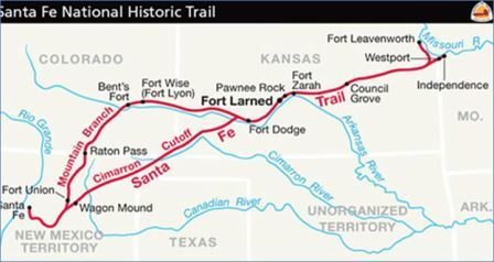
The Santa Fe Trail has two branches, the Mountain Branch and the Cimarron Cutoff. The branches have pros and cons while traveling to Santa Fe. The Mountain Branch is longer, but follows the river, and therefore the animals have water during much of the travel. The Cimarron Cutoff is shorter, but there are more dangers such as running out of water and a higher chance of encountering hostile indians. Bent's Old Fort was almost halfway in travel time within the Santa Fe Trail on the Mountain Branch.
Preparation
Students should learn the difference between intersecting and parallel lines. This lesson should reinforce the difference.
Materials
Intersecting and Parallel lines on the Santa Fe Trail Activity Sheet. You can distribute the activity sheet or go over the questions one-by-one as a class.
Procedure
Teachers have the option of using this as a worksheet for students to do individually or as a group, or the teacher could go over each question as a class.
Questions:
- Between Fort Wise and Bents Fort, is the Mountain Branch intersecting or running parallel to the Cimarron Cutoff?
- From Fort Dodge to Bents Fort, is the Arkansas river intersecting or running parallel to the Mountain Branch?
- To the right of Fort Zarah, is the Arkansas river intersecting or running parallel to the Santa Fe Trail?
- From Fort Dodge to Bents Fort, is the Cimarron Cutoff intersecting or running parallel to the Arkansas river?
- Is the Cimarron Cutoff intersecting or running parallel to the Cimarron River?
- Does the Arkansas River and the Cimarron River generally intersect or run parallel to each other on this map?
- What are the closest forts to the intersections of the Cimarron Cutoff and the Mountain Branch?
- Draw a line from Independence Missouri to Santa Fe. Which branch of the Santa Fe Trail closely follows this line?
- Draw a line from Santa Fe to Bents Fort and a line from Bents Fort to Independence. Which branch follows these lines?
- From the lines you drew, what is the angle of the triangle at Bents Fort?
Note: The Santa Fe Trail via the Cimaron Route is 788 miles, and via the Mountain route is 844 miles. Why would some people travel the long way to get to Santa Fe?
