Place
Shafer Trail Viewpoint
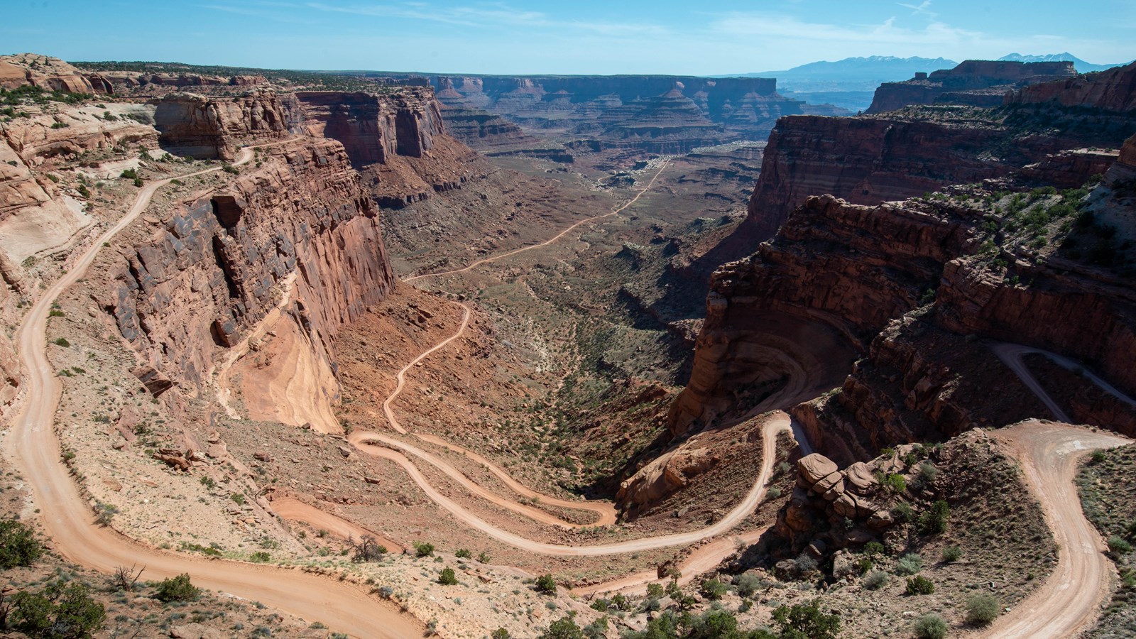
NPS Photo
Scenic View/Photo Spot
A short, 0.9 mi (1.4 km) drive past the Island in the Sky visitor center leads to a breathtaking view of the Shafer Trail.
The Shafer Trail at the Island in the Sky district of Canyonlands National Park is an iconic road that descends 1,500 feet (457 m) through a colorful, massive sandstone cliff. Its function has changed through the years; from a route made by Native Americans to access resources on the mesa top, to a trail for sheep herders moving flocks to better foraging in winter time, and then a road for trucks moving loads of uranium from the backcountry to market. Today, the Shafer Trail is a challenging, unpaved backcountry road for recreational users seeking the experience of a lifetime.
Shafer Trail History
The Shafer Trail is named after the Shafer family, who were Mormon pioneer settlers. Starting in 1916, John “Sog” Shafer, used this trail to move cattle from summer pastures on the mesa top to winter ground on the White Rim sandstone, several rock layers down into the canyon. John Shafer is credited for improving the trail and making access into the canyon easier. Many other trails at Island in the Sky also bear names for the families who worked them.
Expanding upon the work of Sog Shafer, the Atomic Energy Commission widened Shafer Trail and extended it to the White Rim Road to accommodate trucks moving loads of uranium-bearing rock from the backcountry and down to Moab for processing. Many backcountry roads in the Moab area used for recreation today were improved by the Atomic Energy Commission.
After Canyonlands was established in 1964, ranchers were granted a ten-year extension of ranching in the park.
From Ranching to Recreation
Overtime, the use of Shafer transitioned from ranching to recreation. Today, hundred of visitors every year experience the thrill of a lifetime driving down the sandstone cliff to the basin below.
For more information on driving the Shafer Trail, check out the Scenic Drives section under Things to Do.
Accessibility
This small roadside pullout is paved with enough space to accommodate a handful of cars. A short, but unpaved and uneven trail leads to a fenced viewing area.
Driving Tips
Driving the Shafer Trail is something that you’ll never forget, however, it is important to do it safely.
-
High-clearance 4WD vehicles with a low range gear (4LO) are strongly recommended. ATVs, OHVs, or UTVs are not permitted inside the park.
-
Backcountry driving conditions can change rapidly after rain or snow. Check the weather report before starting your trip and current road conditions before heading out.
- Buckle up! Seatbelts are required on all roads.
- Obey the 15 mph (24 kph) speed limit.
- Watch for low overhanging rocks.
- Uphill traffic has the “right-of-way.” Use berms and pull-outs to allow uphill traffic to pass safely.
- Please stay on the trail so as not to disturb biological soil crust. Damaged soils are prone to erosion and invasive species.