Place
Gaithersburg Latitude Observatory
Despite its modest form and obscure location tucked in a residential neighborhood in the City of Gaithersburg, Maryland, the International Latitude Observatory holds an important place in the history of earth science. One among a worldwide network of six observatories established at the end of the 19th century, the data collected by the Gaithersburg observers and at its sister observatories helped scientists better understand earth’s weather conditions and physical characteristics.
Following the 1889 discovery by a German scientist that the earth wobbles on its polar axis, in 1899, the private International Geodetic Association based in Potsdam, Germany created the International Polar Motion Service, which established six observatories around the world for the purpose of measuring the variations in latitude caused by the earth's wobble. Located in Gaithersburg, MD, Cincinnati, Ohio, Ukiah, California, Mizusawa, Japan, Charjui in Russian Turkestan, and Carloforte, Sardinia, Italy, all six observatories sat along the parallel of 39 degrees 08 minutes north latitude so that they could collect uniform computations. From 1899 to 1982, Americans observed polar motion at the Gaithersburg Latitude Observatory in concert with scientists around the world. The site serves as a reminder of the extraordinary 20th century scientific progress aided by unremitting international cooperation.
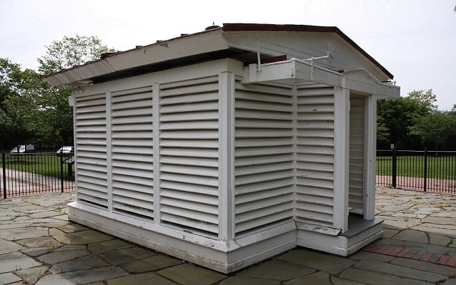
The Gaithersburg Observatory was designed by Edwin Smith, Chief of the Instrument Division of the U.S. Coast and Geodetic Survey. This agency, now the National Oceanic and Atmospheric Administration, operated the International Polar Motion Service observatories in the United States. In 1891, Smith began conducting measurements of the variation of latitude from his home in Rockville, Maryland. He made nearly 1,800 individual measurements on 146 nights, until his regular work forced him to discontinue his observations. However, when the International Geodetic Association allocated funds for the purchase of land in Gaithersburg in 1898, it entrusted Smith with the construction of the observatory. He designed the small, 13-foot-square, one-story building to accommodate a large Zenith telescope manufactured in Germany. Operated by pulleys and wheels, the gable roof opens to expose the interior of the building and allow for stargazing. The Gaithersburg Latitude Observatory began operating on October 18, 1899. The six stations documented latitude variations by precisely measuring the location of a constant set of stars.
About 200 feet to the south of the observatory is the Meridian Mark Pier, a white metal pagoda-shaped object about four feet high by two feet square, which was used to align the observatory’s instruments. In addition, five U.S. Coast and Geodetic Survey monuments occupy the observatory grounds. Set by the U.S. Coast & Geodetic Survey, they establish exact geographic longitude and latitude points, elevation above sea level, and the direction of magnetic north. The Observatory RM-1 monument, placed in 1966, is still used today for positional testing of Global Positioning Systems (GPS).
The International Polar Motion Service program faced domestic and international troubles caused by international wars and economic depression. In 1915, economic constraints forced the Gaithersburg and Cincinnati stations to close. During World War I, the Charjui station lost contact, but after fighting ceased, the Soviets continued to participate in the program with the establishment of a new station in Kitab in Uzbekistan, USSR. While the Cincinnati station remained closed and was eventually dismantled, the Gaithersburg Latitude Observatory resumed operations in 1932. Despite the location of stations in two Allied nations and two Axis nations, cooperation between the observatories continued throughout World War II. Observations continued at Gaithersburg observatory until computerization rendered its use obsolete in 1982.
In 1987, the City of Gaithersburg acquired the property from the United States as part of its Historic Surplus Property Program. The city has restored the observatory and created a community park surrounding it, known as Observatory Park. The Gaithersburg Community Museum interprets the site and holds special educational events, including stargazing and other astronomy events (click here for more information on events). In December 1989, the site became a National Historic Landmark.
Although superseded by newer technologies, the wealth of data returned from Gaithersburg and the other five observatories is still used by scientists today to determine polar motion, the size, shape and physical properties of the earth, to predict climate and earthquakes, and to aid the space program through the precise navigational patterns of orbiting satellites. Hundreds of scientific papers and studies have cited the program’s findings. The Gaithersburg International Latitude Observatory played an integral role in advancing humankind’s awareness of its own planet Earth.
Click here to watch a short movie on the International Latitude Observatory!
National Historic Landmark Nomination for the Gaithersburg Latitude Observatory.
National Historic Landmarks (NHLs) are historic places that possess exceptional value in commemorating or illustrating the history of the United States. The National Park Service’s National Historic Landmarks Program oversees the designation of such sites. There are just over 2,500 National Historic Landmarks. All NHLs are also listed in the National Register of Historic Places.