|
NEW RIVER GORGE
PROCEEDINGS New River Symposium 1984 |

|
HISTORY OF THE MANAGEMENT PLAN FOR THE SOUTH FORK OF THE NEW RIVER IN N.C.
Jay Wild
New River State Park
N.C. Division of Parks and Recreation
Jefferson, N.C.
The New River is an ancient stream rich in its natural history as well as a wealth of cultural and human history. It has also been a stream subject to man's study, use, development, and exploitation since its early discovery and settlement. The management plan for the New River State and National Scenic River evolved as a result of a long history of fervent, emotional battles between proponents of each of the several characteristics common to the river. The legislation creating both river designations and the staff which subsequently developed the management plan attempted to protect those features unique to the river as well as to provide for little disturbance of the existing lifestyle in the New River valley.
Along the banks of the same river that today sports profuse blooms of spring and summer wildflowers and offers a resting area for migrations of waterfowl, Indians once settled or passed through on hunting expeditions leaving projectile points, pottery shards, and stone tools to be unearthed, examined and wondered over by farm workers and archaeologists. A way of life developed in the area based on a respect for nature.
With the local economy linked closely to those natural resources, the river and its tributaries offered the residents rich, fertile, bottomlands in which to tend their crops. It offered the power to grind their grain and operate their mills. It offered them a place to relax and fish. Also, it offered the healing and restorative powers of nearby mineral-rich springs and the spas which sprang up around them.
In 1962 the actual history of the management plan for the New River Scenic River began. Appalachian Power Company applied with the Federal Power Commission to conduct a feasibility study for a non-federal hydroelectric power project on the New River in Va. and North Carolina. That application was granted and the study was completed in February of 1965. Immediately APCO applied for a license to build a two-dam hydroelectric and pumped-storage facility named the Blue Ridge Project. The project offered to generate power for periods of high demand at the project's upper reservoir. During periods of low demand, power from elsewhere in the APCO system would be used to pump the water back up from the lower reservoir. The proposal met with relatively light protest primarily from the landowners who were to be directly affected.
During that project's pre-licensing review, the U.S. Department of interior requested that the plan include enough storage capacity to provide flushing water during periods of low flow to dilute the pollution dumped into the Kanawha River by industries downstream. As a result of this recommendation and hearings held on the project, APCO submitted a revised proposal called the Modified Blue Ridge Project with an upper reservoir of 26,000 acres and a lower reservoir of 12,390 acres. The upper dam would have been 300 ft. high and 1,700 ft. long, the lower, 236 ft. high and 2,000 ft. long. This nearly doubled the size of the original project. At least 2,700 inhabitants of the New River valley would have been displaced with the loss or replacement of 893 dwellings, 12 cemeteries and 5 post offices. An estimated $13.5 million annually would have been lost in crop and livestock sales. Power generated for peak load would have gone to large urban areas of the East and Middle West during the estimated 50 year life expectancy of the plant. For every 3 units of electricity generated, 4 would be used to pump water back into the upper reservoir.
Needless to say opposition to the modified plan was widespread as local people and outside supporters protested the injustice of having to sacrifice their homes and lifestyles to provide peak load power at a net negative energy cost to people outside the area and to flush away pollutants dumped by other "outsiders" into a river some 250 miles away.
The opposition began among a group of local people united as the Upper New River Valley Association. It grew and attracted other organizations such as the Issac Walton League, Conservation Council of Virginia, and the West Virginia Highlands Conservancy. Meanwhile hearing after hearing before the Federal Power Commission led to decisions in favor of licensing the project. Modifications were made in the plan to reduce the amount of drawdown during low flow periods, cutting the size of the mudflats to be left during power generation and eventual elimination of "pollution dilution" storage. These changes reduced the size of the lower reservoir, but the relative size of the project remained the same.
Again the group of opponents to the project grew, It became a national organization and an alternate strategy for fighting the project outside the courts was devised. That strategy was based on seeking inclusion of the New River into the National Wild and Scenic Rivers system under the federal Wild and Scenic Rivers Act of 1968.
There were two ways this could be accomplished. Congress could enact legislation to fund a study of the river by the Department of Interior to see if it qualified, then Congress could vote to include it in the system. In the second method, the governor of the State could apply to the Secretary of the Department of Interior to include a river segment within the state as a federal river if that river segment had been designated a state scenic river and the state had adopted a management plan under which a state agency would manage the river at no cost to the federal government. After receiving that application, the Secretary must by statute carry out a study to see if the river meets the criteria for designation into the federal system. If so, then Interior can legally establish the scenic river without any action by Congress. The federal designation was sought on both of these fronts.
Bills were introduced in Congress in late 1973 and early 1974 for a New River study. The bill passed in the Senate, but not in the House. As a result of their failure, the Governor then submitted his application in December 1974 to the Secretary of the Department of interior based on the fact that in 1977 North Carolina had established a state Natural and Scenic River System and had designated a 4.5 mile segment of the main stem of the New River as a State Scenic River in March 1974. A management plan had been developed for that segment and another state study was begun in late 1974 to include the entire South fork of the New within the state designation. In that original management planning process the 4.5 miles of river were tested according to the criteria mandatory for N.C. Natural and Scenic rivers. Those criteria relate to water quality, water flow, river segment length, environmental quality, boundaries, and public accessibility, in this system "natural" rivers are "those free-flowing rivers and adjacent lands existing in a natural condition and generally inaccessible except by trail." "Scenic" rivers are "largely free of impoundments with adjacent lands largely primitive and largely undeveloped but accessible in places by roads."
After public hearings were held in early 1975, the section of the South Fork proposed for inclusion was reduced to 22 miles and in May the N.C. General Assembly placed 26.5 miles of river under state management as a state scenic river. The requested study of the New River by the U.S. Department of Interior was completed in 1976 and federal designation was approved by the Secretary of the Department of Interior in April 1976. Congressional leglslation was also enacted to include the river in the Federal Wild and Scenic Rivers system and included a provision to prevent construction of any power project that would innundate the segment designated as a National Scenic River. That congressional bill was signed into law on September 11, 1976 by President Gerald Ford and the 26.5 mile river segment became both a National and State Scenic river.
In September 1976 following the inclusion of the river into the federal system a set of objectives for field operations was developed for maintaining the conditions for both the federal and state systems. Those objectives provided for a land and water based patrol of conditions on the scenic river and its boundaries. It provided for cooperative enforcement of regulations governing water quality standards, sedimentation control, hunting and fishing, and flood plain development by many agencies within the N.C. Department of Natural Resources and Community Development.
The management plan for the 26.5 miles of the New River became finalized and formalized into the master plan for the South Fork New River in 1977. The river segment is to be managed by North Carolina as a National Scenic River at no expense to the federal government, and as a State Scenic River under the directives of the state Natural and Scenic River Act of 1971. The bill including the river into the state system set limits on land acquisition, provided for continued agricultural use of lands adjacent to the river, and set criteria to be monitored to keep both the state and federal designations.
Boundary limits were set as the visual horizon from the river, but no less than 20 feet wide nor more than 320 acres/miles of river. Water quality was to be maintained at class — C (suitable for fish and wildlife propogation, boating, wading, but not bathing or drinking) with river flow such that the minimum continuous flow would be enough to maintain the natural ecology of the stream. Public accessibility allowed for roads parallelling the river and even crossing the river.
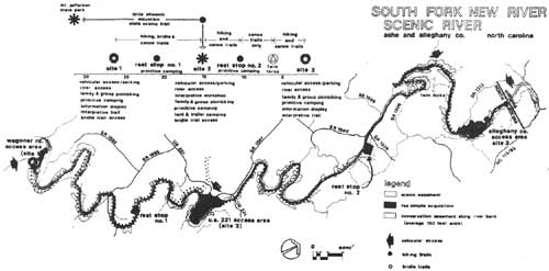
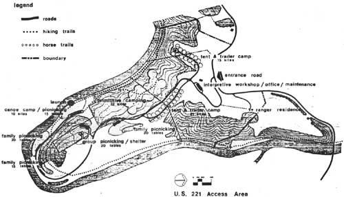
More specifically, the master plan calls for 5 state-owned public access sites to be developed along the 26.5 miles of river interconnected with a strip of scenic and conservation easements. Of the 5 access sites, 3 will provide "drive-in," "hike-in," or "boat-in" access with a range of day use and overnight activities offered. The remaining 2 access sites will be rest stops for boaters, horseback riders, or hikers with no vehicular access provided but picnicking and primitive camping available. Incorporated in the plan is a privately owned and operated campground, Twin Rivers Campground, at the confluence of the North and South forks of the New. Included in this paper are the plans for the state-owned sites.
In all, up to 550 acres were identified for acquisition as public access sites with up to 1,500 acres of easement needed to protect water quality and the scenic integrity of the managed section. Land acquisition began in 1976 with the fee simple donation of an 8.81 acre tract by one of the members of the National New River Committee. More gifts of easements followed in the same year from other supportive committee members. Land acquisition by the State of N.C. began in late 1979 and early 1980 with the purchase of the Wagoner Road Access, the Alleghany County Access, Rest Stop # 2, and a portion of the U.S. 221 Access. Since then another conservation easement has been obtained near the 2nd rest stop. Easement gifts currently total 4.5 miles of river front within 33 acres of land.
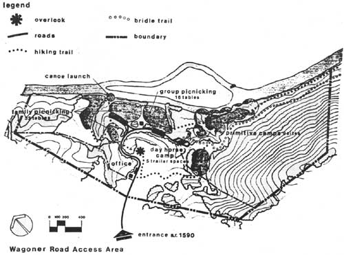
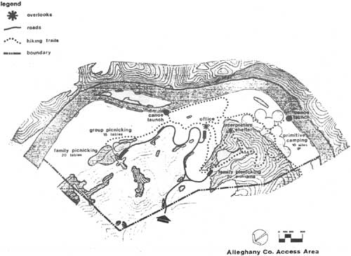
Two of the major access sites have been developed for interim use pending appropriations for further development. The Wagoner Rd. Access was formally dedicated and opened in May 1980 offering picnicking, boater access and egress, primitive canoe-in camping, water and pit toilets and an access road. In 1982 interim facilities were completed for primitive boat-in camping at the Alleghany County Access with water, grills, and pit toilets provided. Access to that site is currently limited to boater access. The N.C. Division of Parks and Recreation is currently developing a five-year plan for the entire Division which will identify funding and development priorities for these and the remainder of the access sites.
Staffing is currently provided through a permanent park superintendent, permanent ranger, and 3 seasonal employees. The staff operates both Mt. Jefferson and the New River State Parks. Final staffing proposed the establishment of another permanent ranger and additional seasonal support staff.
Through the efforts of a coalition of residents of the New River Valley and their friends and supporters nationwide, the unique character of the river and the way of life that developed alongside it have been preserved and protected for generations. The battle cry "New River — Like It Is" is a truth today. The State's management plan attempts to preserve its character and tradition while providing compatible recreational use and guided understanding of the resource. As the New River State Park is developed generations of people now and in years to come will have the opportunity to share the river's natural and cultural history and come to understand why the fight to save the New was such an emotionally and tenaciously fought issue.
(click on image for a PDF version)
(click on image for a PDF version)
(click on image for a PDF version)
(click on image for a PDF version)
BIBLIOGRAPHY
1. Schoenbaum, Thomas, The New River Controversy, John Blair Publishers, Winston-Salem, 1979.
2. N.C. Department of Natural and Economic Resources, Division of Parks and Recreation, Master Planning Unit, South Fork New River Scenic River Study 1977.
3. General Assembly of N.C. 1971 Session, Senate Bill 432, Natural and Scenic Rivers Act of 1971.
4. N.C. Dept. of Natural and Economic Resources, Division of Parks and Recreation, "Questions and Answers Concerning the Proposal to Designate the South Fork New River in the State System of Natural and Scenic Rivers," 1975.
5. General Assembly of N.C. 1975 Session, House Bill 789, "Act to Lengthen the Segment of the South Fork, New River, in Ashe and Alleghany Counties Included in the N.C. Natural and Scenic Rivers System."
6. N.C. Dept. of Natural and Economic Resources, Division of Parks and Recreation, June 1975, Revised Management Plan South Fork New River and Main Stem New River, N.C.
7. 94th U.S. Congress, 2nd Session, House Bill H.R. 13372, "A Bill to Amend the Wild and Scenic Rivers Act (82 Stat. 906; 16 U.S.C. 1271)," June 1976.
8. U.S. Dept. of interior, Bureau of Outdoor Recreation, Final Environmental Statement, South Fork New River National Wild and Scenic River, N.C., March 1976.
9. Webster, William A., "Interim Plan of Operations for South Fork New River," Division of Parks and Recreation, September 1976.
| <<< Previous | <<< Contents>>> | Next >>> |
newriver-84/sec15.htm
Last Updated: 08-Jul-2009