|
NEW RIVER GORGE
PROCEEDINGS New River Symposium 1984 |

|
THE ARCHITECTURE OF THE NEW RIVER VALLEY, NORTH CAROLINA
Davyd Foard Hood
Survey and Planning Branch
Division of Archives and History
Raleigh, North Carolina
In the Spring of 1976 in response to a proposal by the Virginia Electric and Power Company to build a dam on the New River, the State of North Carolina dispatched teams of architectural historians and archaeologists to the New River Valley to assess the architectural and archaeological resources which would have been destroyed (or otherwise affected) by the proposed dam. Because of the long prehistoric Indian occupation in the valley the archaeological resources were expected to be impressive. The significance of the buildings there was less well known, but they too proved to be vital to our understanding of the region's history. Approximately 150 individual sites in Ashe and Alleghany counties — representing either individual houses or a farm complex — were recorded. Of that group five individual houses and their outbuildings, one church, a mineral springs resort, and the large Grassy Creek Historic District were nominated in 1976 to the National Register of Historic Places. Although the dam was not built the threat of its construction discouraged normal maintenance and repairs to occupied houses and farm outbuildings and led to the abandonment of many others. No other event in the valley's history has so disrupted its way of life. [1]
* * * * * * *
The first extensive and recorded accounts of the New River Valley in North Carolina were made in December 1752 by the Moravian Bishop Augustus Gottlieb Spangenberg who was searching for a large tract of 100,000 acres on which to establish a Moravian colony. On December 14, 1752, having found his way out of the New River Valley and then encamped at the Lewis Fork of the Yadkin River, he wrote,
"Here we are at last, after a difficult journey across the mountains. We were completely lost and whichever way we turned we were walled in. Not one of our company had ever been there before and path and trail were unknown — though how can one speak of path or trail where none existed? We crossed only dry mountains and dry valleys and when for several days we followed the river [New River] in the hope that it would lead us out, we found ourselves only deeper in the wilderness, for the river ran now north, now south, now east, now west, in short to all points of the compass! Finally we decided to leave the river and take a course between east and south, crossing the mountains as best we could. One height rose behind the other and we travelled between hope and fear, distressed for our horses which had nothing to eat." [2]
Similar sentiments were expressed some seventy-five years later by Dr. Elisha Mitchell who visited Ashe County in 1827 and 1828 while on a geological and agricultural survey. Writing of his climb to the top of Negro Mountain, now Mt. Jefferson: "And a rugged ascent it was! Some of the plantations in view presented a noble appearance, but oh, what an ocean of mountains!" [3] Dr. Mitchell also commented on the particular qualities of the soil and the quantity of game, echoing the words of Thomas McGimsey who wrote to Thomas Henderson, the editor of the Raleigh Star, on 3 May 1811,
Great part of Ashe County is mountainous and hilly, yet the soil is extremely rich, yielding an abundance of wheat, rye, oats, barley and buckwheat and other vegetables equal to any cold country on earth.
This is a fine county for pasture and meadows, from which great numbers of cattle and sheep are raised, which bring much wealth to the farmer. The air is pure and the water is good, if not superior to any on earth. People live long in Ashe County.
The face of the country is clothed with large and lofty timber of black walnut, sugar tree maple, buckeye, hickory, chestnut, and spruce pine. Clover, strawberries and blue grapes are natural to grow everywhere. Cranberries also in great plenty.
As that country has always had plenty of game, the first settlers who lived there for the purpose of hunting, were much opposed by the Indians, in particular by the Shawnees and the Cherokees, until the end of the late war. Since they have made no incursions into these settlements.
The main water courses are the New River, or head of the Great Kanawha, and its auxiliary branches flowing from the Blue Ridge, Iron and Stone Mountains.
The country abounds with mines and minerals. There are at present five sites of good iron works within the County of Ashe. Great store of minerals has lately been found which is thought to contain great quantities of silver and gold.
The people of Ashe County send to market cattle, sheep, butter, cheese, lard, beeswax, venison hams, deer-skins and ginseng to the amount of upwards of thirty thousand dollars yearly.
People in this County improve more in Religion than in the study of arts and sciences but it is hoped that more pains will be taken to improve the youth in the one as well as the other. [4]
The same qualities and quantities of game and wildlife which had attracted hunters to the New River Valley in North Carolina in the first half of the 18th century and through the Revolutionary period also attracted permanent settlers beginning in the 1750s. However, the settlement did not take on the appearance of permanence until the eve of the Revolution by which time their numbers had substantially increased. [5] This influx of settlers into the New River Valley reflected both the gradual western expansion of settlement in North Carolina and the parallel movement south of younger brothers and sons of Virginia families. Settlers from Virginia came mostly from Montgomery County and successively Wythe County (1790) and Grayson County (1793) which stretches across the northern borders of Ashe and Alleghany counties. Among these men was Captain John Cox (1739-1818) who acquired lands on Cranberry Creek after the Revolutionary War and moved here. [6] Others including members of the Sturgill family followed a similar pattern. [7] These familial and geographical relationships would be a predominant influence on the settlement of the New River Valley in North Carolina. The facility of transportation and communication with Virginia served to reinforce these interests as Ashe and Alleghany counties were removed from much real contact with the rest of North Carolina. This factor contributes to the area's uniqueness in the state and includes the New River Valley with those other North Carolina communities—most notably Warrenton—located along the Virginia-North Carolina border which being familially and economically tied to Virginia are culturally as much a part of Virginia as North Carolina. The results of this relationship are as tangible as they are intangible.
In 1799 Ashe County was established to include ". . . all that part of the County of Wilkes, lying west of the extreme height of the Appalachian Mountains, . . ." including all of what are now Ashe and Alleghany (1859) counties and part of Watauga County (1849). Ashe County was named for Samuel Ashe (1725-1813), a Revolutionary patriot and governor of North Carolina (1795-1798). [8] The development of a small iron industry followed on the formation of the county. At the beginning of the 19th century land grants were available to those who would agree to set up iron forges. Meredith Ballou (______-1847), among others, had visited Ashe County in the late 1790s and found rich iron ore deposits in the hills along the North Fork of the New River. [9] The mining industry's early profitability and need for workers encouraged settlement near the valley sites of the iron forges and along the banks of the nearby creeks and rivers. These early settlements grew naturally into farm complexes and as the iron industry flexed forward and later declined the farms grew in importance to the family which now came to depend exclusively on the farm for the family's existence.
That the iron industry played a vital part in the settlement of the New River Valley and Ashe County is without question. But the major and long term economic motive for settlement in the valley was agriculture. Dr. Mitchell had predicted as much in a diary entry during July 1828. [10] He reiterated those characteristics of the valley described by the Moravian leader Spangenberg — the richness of the soil, the abundance of water and timber, and the existence of sufficient mineral resources to complete the collective body of natural resources with which and from which man could create a sustaining life and society with his neighbors.
It is in the satisfaction of housing demands for this evolving agrarian community of families and its agricultural economy that the architectural character of the New River Valley has been formed and it is almost exclusively in these terms — in the growth and development of this agricultural economy — that an architectural analysis of the New River Valley should be interpreted. Settlement, evolving prosperity, and agrarian success are each exhibited in an architectural product and have marked the degree of building sophistication aimed for, achieved, and as importantly, maintained.
But while agriculture sustained life in the New River Valley, geography was also an influential factor in the evolution of its society, economy, and the correspondent architectural character of the valley. The cutting of the New River's course through the land has created a landscape of great complexity with steep hills and narrow valleys — Mitchell's ocean of mountains. The rolling, richly covered topography with its sinuous bends of the river and its tributaries and the parallel curves of the hills created meadows among the hills and along the river bottoms — neatly tailored farmsites — on which the early settlers established and developed their farms. The hills enclosed and enframed them in an unique and vast isolation which encouraged the introversion of subsistence farming and an independent family life. The geography thus necessitated a close, specific, and complimenting relationship between the farm and its supporting fields and encouraged an intimate grouping of farm structures — houses, barns, granaries, smokehouses, corncribs, root cellars, springhouses, and later silos, poultry sheds, tobacco barns, and equipment sheds. There is no trace here of the formal 18th century plantation plan of the coastal plain but rather the strength of organic response — a quality achieved in the evolutionary course of agrarian development in the 19th and 20th centuries.
The major factor in the development of the social order here has been the tilling of a small self-contained family farm unit. While the state's economic history in the 18th and early 19th centuries has been written mainly in agricultural terms — excepting naval stores and up to the development of textile mills — it is also true in the New River Valley. In the Coastal Plain and, to a lesser extent, in the Piedmont there were markets available and methods of transportation for getting goods and produce to them. Transportation opportunities diminished as one moved inland from the coast and away from the Tidewater Virginia and South Carolina borders so that in the mountain area agricultural practices developed less along commercial farm lines, than as the means of sustaining the family unit. Thus the size of farms changed slowly and unnoticeably, mainly increasing and decreasing through the division of a family farm or the combination of farmlands as a result of marriage. This factor also encourages the relative evenness of the buildings here. Farms of similar size would and did support families and operations of an approximate size and scale. In consequence the houses and outbuildings themselves are similar in size, material, and design.
Another important consideration here is that this pattern of agrarian development saw only the most minor changes until the last decades of the 19th century. Interruption has been insignificant. The terrific economic and social disruption of the Civil War and more especially its aftermath which had such a major impact on the quality and character of life in the Coastal Plain was less severe here, another of the factors in making the architectural fabric of the valley so unique — a piece of even homespun. [11] The architectural character has developed independently and indigenously; pressures of style and social change have been at a minimum. There are, of course, variations in this context with buildings which break the mold or move ambitiously beyond it, but the homogeneity of the building remains intact and inviolate. The tie of the building to the soil is a principal factor in the aesthetic cohesiveness.
Another important factor for consideration here is the definite absence of the Georgian style, and the minimal presence of the Federal style which exerted considerable influence on the architectural character of much of the rest of the state. At the same time there is also little evidence of the Greek Revival style which so dominated antebellum building in North Carolina. The architecture of the New River Valley is, therefore, a history of building which occupies one place in the state and the oneness of response to repetitive demands — a remarkable sameness of type, form, shape, material, and ornament. It is a repetition and sameness which is never boring but, because of its unpremeditated functionalism, it appears as natural in the landscape as the very trees and hills of the terrain. One of the most striking characteristics of buildings in the New River Valley is this containment of time in architectural practice, from the early 19th century to the valley's peaking at the turn of the century. This is a very short period from an exterior point of view but it seems after our survey, to be an appropriate length allowing for the expression of the full cycle of wood construction, from the most simple log cabin, through the hewn log house, the early frame house, to the airy elaborateness of the mechanical manipulation of wood in the final stage at the end of the 19th century.
The pioneers who settled in the New River Valley were familiar with the valley and its special character. That they chose the valley and remained here is an important acceptance of its particular character. The introversion of pioneer mountain life encouraged by the landscape was a deliberate extension of the strong individualism which defined their approach to life. The earliest building form was, as noted earlier, the log cabin built as shelters for Virginians and North Carolinians who organized hunting parties into the valley. These first structures were only meant to be temporary housing and consequently were quickly, and rudely, built. A similar practice was followed when settlers — and many of the above hunters numbered among them — came, or came back, to stay. The first requirement was to provide immediate shelter for the settler, his family, and any domesticated animals. The fact that none of these earliest buildings are known to remain owes as much to this matter of expediency as to a series of floods including those of 1916 and 1940 which washed many houses away. Most of the early homesteads had been established along the river and its tributaries on whose banks the early transportation routes were established. The double pen, or dog trot, form was ideal for this purpose. Two pens, or blocks, square or rectangular in shape, were built with a passage several yards wide between. The family could live on one side and the other could be used as a barn and granary to store foodstuffs for the family and animals. The animals could seek shelter in the passage. Alternatively, the second block itself became a stable with the passage between used for storage. This early architectural form sheltered all the activities and functions of the farm/homestead under one roof.
As necessity prevailed — with the growth of the family and the increased productivity of the farm — a new log house was built on whose construction more time and skill were expended. The old log cabin often became a granary or stable. It is this second generation of log construction which provides the first structures for our study. They are usually of half or full dovetail construction, built of hand-hewn logs and have either dry-laid or mortared stone exterior chimneys. In form they range from one story, story-and-a-half, to full two stories. As log construction was utilized during the entire 19th century it is not possible to date houses by a progression from the one-story to the two-story house for size and quality of construction depended on the resources of the builder at all times. In addition most of the log houses which survive appear to have been covered originally with weatherboards.
Pre-eminent among this second generation of log houses is one built in the mid-19th century by Samuel Cox (1811-1868) on a tract of land acquired from his father Joshua Cox in 1832. [12] His house, one of the best preserved of the valley's log houses, is representative of many built in the valley on or near the family homestead by second and third generation descendants of early settlers. It stands on a hilltop overlooking the site of the Cox homestead on the waters of Cranberry Creek and the South Fork of the New River. The house has dovetail construction and appears always to have been weatherboarded; bark remains on some of the logs and much of the clay daubing is still in place. A stone chimney — common in the valley — stands on the east gable end. While the shed porch appears to be original, the one-story frame ell was added in the early 20th century by the builder's son Franklin Cox (1853-1905). The interior of the first story has a two-room plan — as did many log houses — and is finished with flush sheathing. An enclosed stair provided access to the second story which was left as one large room.
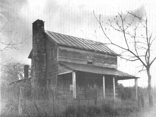
|
| Samuel Cox House. Scottsville Vicinity. Ashe County. |
Built about 1870, the William R. Neaves House is similar to the Cox House but has a shorter second story. [13] This reduced height two-story house is often called a one-and-three-quarter house and is a type which was frequently built in the valley. In or about 1895 a two-story frame addition was made to the log house on the gable end opposite the stone chimney; at this time a shed porch was carried fully across the five-bay front (west) elevation overlooking the North Fork of the New River which flowed in front of the house and separated it from the public road. Behind the house a stone root cellar, built into the hillside, has a gable roof with a weatherboarded gable front. The other outbuildings — all frame — are in a row to the south of the house on the same low plateau above the narrow bottoms.
Although the Cox and Neaves houses are late in the chronology of building in the New River Valley, their present appearance and relative degree of integrity make them useful and representative examples of the more permanent log houses.
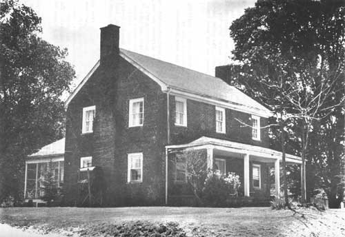
The majority of New River Valley farmers were living in weatherboarded log houses or simple log cabins; however, there were several more affluent men who, with their families, lived in a higher state. There are four surviving brick houses in the New River Valley which were erected between ca. 1816 and 1865. [14] The oldest house in the group is a substantial, though plain, two-story three-bay brick house erected by Aquilla Greer, the progenitor of the Greer family who dominated the Grassy Creek community. Greer, a resident of Grayson County, Virginia acquired 400 acres on the waters of Grassy Creek on December 16, 1816 and built this house as the seat of his plantation. [15] Unfortunately the interior of the house was remodeled in this century.
The McMillan House, somewhat smaller in scale and probably dating from the 1830s or 1840s, survives nearly intact though deteriorated. It has a two-room plan on each floor with a transitional Federal-Greek Revival style finish including molded door and window surrounds, chair rails and baseboards, two-panel doors, and bold mantels. A unique feature of the house is the stair rising on the rear elevation which connects the first and second stories. The house is thought to have been built by Andrew McMillan who acquired a tract of 300 acres here on Nathans Creek in 1810. [16]
Nearly contemporary with the McMillan House is a two-story brick house built by John Baker (1783-1855), who came to Ashe County from Grayson County in the first decade of the 19th century and acquired lands on Grassy Creek. The Flemish bond brickwork of the front, east elevation is particularly noteworthy. After Baker's death the house passed through a number of hands before it was purchased by William Waddell (1835-1912) who, according to family tradition, is responsible for the remodeling, ca. 1870, which gave the house its present appearance. [17] The richly scrolled door and window surrounds and bracketed eaves are matched on the interior by an equally splendid and fascinating woodwork.
Two of the most prominent names in the county's 19th century history are associated with what is thought to be the earliest frame house recorded during our study. The oldest portion of the dwelling known as the Bowers-Cox House was built for George Bowers on a tract of some 400 acres on Silas Branch which he sold to Dr. Aras B. Cox in 1852. [18] The house is thought to have been built in the 1820s or 1830s. Bowers (____-1861), a successful farmer and businessman, represented Ashe County in the North Carolina Senate from 1812 to 1817, and sometime after 1828 built a large brick house in the county seat which served as both his residence and an inn. Dr. Cox, who was active in civic affairs and served as Clerk of Superior Court in 1849 and 1853, wrote an early history of the area, Footprints in the Sands of Time.
|
| Aquilla Greer House. Grassy Creek. Ashe County. |
Another of the early frame houses is the William Weaver House which sits on lands stretching for just over a mile along the South Fork of the New River. The oldest portion of the house is the two-story three-bay main block built shortly after William Weaver purchased the property from Meredith Ballou in 1845. [19] In 1890, his son, Andrew (1843-1932) added a one-story ell containing a kitchen and pantry. About five years later he extended the ell to include a dining room and raised it to two stories in height. At the same time he added the richly decorated two-tier porch across the front elevation; it retains traces of its original blue, chartreuse, and white painting scheme. The farm owned by Fred Weaver, Andrew's son, retains farm outbuildings dating from the three generations of the Weaver family ownership. William Weaver (1787-1876) and his descendants, excepting his grandson Fred (1886- ), are buried in a family cemetery on a hilltop to the southeast of the house.
The Weaver House and Farm is an important example of a New River Valley farmstead which has descended in a single family during three generations and occupied by them for nearly 140 years.
Another significant example of continued family ownership is the John M. Pierce House which began as a small log house, erected about 1871. Pierce built his one-story house on the edge of the lands his father Rufus Kincaid Pierce (______-1898) acquired in 1845 on the South Fork of the New River. [20] The first expansion of the log house was the addition of a one-story frame rear ell. But it was the dramatic remodeling of 1892 which extended the log house by two bays to the west, raised it to two stories in height, and included a handsome two-tier porch arrangement which brought the house to its turn-of-the-century appearance.
During the fourth quarter of the 19th century a transition from self-sufficient farming to cash crops began to be apparent. A study issued in 1913 by the U.S. Department of Agriculture and the North Carolina Department of Agriculture stated,
"It was not until about 1880 that Ashe began to make any considerable progress along agricultural lines, a few good plows had been introduced as early as 1872, but these were exceptions. Before this time nearly all of the farm implements in the county were homemade, the iron being taken from mines in the country.
The cutting and shocking of corn was practiced for the first time in 1882 and about the same time wheat growing over the entire county began. The first grain drills were introduced in 1884. Scarcely any commercial fertilizers were used prior to 1891." [21]
In tandem with the flow of produce out of the valley, money was now available to purchase sawn, turned and molded woodwork which was either locally produced by the nascent lumber industry or brought into the valley by the railroad. The farmer and house builder was no longer dependent on his own skills with woodworking tools for the ornament of his farmhouse but had at his disposal a catalogue of brackets, braces, turned posts, spindles and balusters, bargeboards, moldings, and other devices which became a part of the vocabulary of local building. Quite naturally the architectural woodwork and hardware available to the builder was similar to that available to other builders in the state. A belated Italianate influence together with that of the Stick Style and the Queen Anne is seen in frequent and combined harmony on the houses which were built or remodeled in this period.
It is the collective effect of these three factors — the need for new housing, a rising prosperity, and the availability of decorative millwork — operating throughout the valley from the 1880s through the 1910s which produced a cohesive and impressive collection of late-Victorian farmhouses. This group of buildings predominates in the landscape. During the decades around the turn of the century descendant generations of the valley's early families established new farms or erected new and larger farm seats. These builders included members of the Gambill, Greer, Blevins, Neave, Reeve, Sturgill, Phipps, and Waddell families among others. Although nearly all of the houses are now painted white this was not always so. Many of the houses remained unpainted for years while others had only painted facades. Mrs. Clyde Cox, the owner (in 1976) of the L. F. Young House remembers that when she came to the house as a young bride it was painted red with yellow and white trim, and that a trellis of pink roses carried across the front porch. [22]
The preference for the rectilinear blocks of earlier log houses survived here in either a T-plan or L-plan. The ends of the block were sometimes bayed. The houses are nearly all three bays wide on the front elevation, two stories in height, clad in weatherboards and have either interior or exterior gable end chimneys. Roofs are either hipped or gable, or a combination of the two. The interior generally follows a center-hall plan with equal size rooms on either side, usually a parlor and bedroom. The kitchen and a dining room are contained in a one or two-story rear ell.
|
| William H. Billings House. Piney Creek Vicinity. Alleghany County. |
Porches are of two major types. The first is a one-story porch which is carried across the full front elevation of the house sometimes wrapping the corner of the house and continuing along its side. Its shed or hipped roof is supported by turned posts with brackets and connected by spandrels and balustrades. On some houses this porch was two-tier and sometimes engaged under the house's gable roof. The second type is the more impressive two-story gable fronted porch centered on the front elevation and protecting entrances on each story. The gable fronts most often feature imbricated patterns of diamond, rounded and other-shaped shingles which are framed by jigsaw-cut bargeboards on sometimes bracketed eaves. Spandrels of varying elaborateness often fill the peak of the gable. Behind the porch and set in a flushly sheathed bay, molded surrounds enframe the doors with fixed sidelights and transoms decorated by jigsaw-cut ornament. Window surrounds are similarly molded; blinds were frequently a part of the scheme but most have been lost or removed. On the L-plan the back porches are ranged in the interior of the L and sometimes connect to a springhouse or well house. On the T plan porches may completely surround the ell with a well head, pantry or storage room breaking the encirclement.
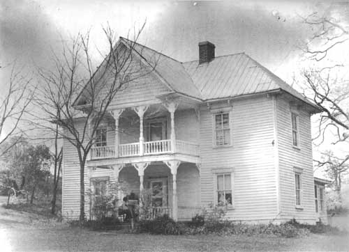
The Burgess Cox Waddell House and the William H. Billings House are particularly representative of the architectural character of domestic building in the New River Valley at the turn of the century, and exhibit the range of building form and ornamental woodwork used at that time. Mr. Waddell (1864-1946) built his house in 1889 and inscribed the date on the lintel of the surround enframing the window in the porch's gable front. [23] The two-story three-bay frame house has a two-tier center bay porch on the front elevation, exterior gable end brick chimneys and a one-story ell and shed room on the rear elevation. The porch remains as built except for the first-story railing which is now lost. Behind the porch the entrances are set in flush sheathing and flanked by sidelights and transoms whose patterned sawnwork was seen frequently throughout the valley.
William H. Billings (1838-1935), the bottler of Billings' Bitters and one of the richest farmers in the valley, purchased a part of the extensive Parsons family farm and erected his house in 1898. [24] The form of the house is nearly identical to that of the Waddell House and consists of a two-story main block with a one-story ell. Mr. Billings' prosperity is indicated by the rich detailing of the porch, the brackets set under the eaves, and the diamond patterned molding on the window cornices. The Parsons family cemetery is located on the farm; Mr. Billings is interred there with the earlier owners of the farm.
|
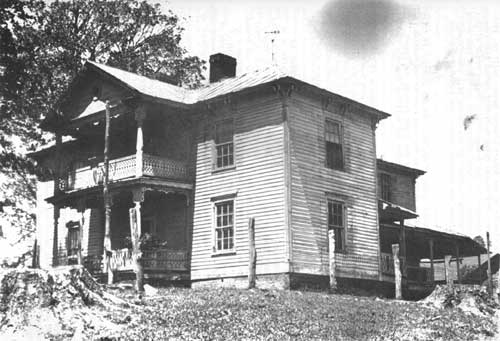
| John F. Greer House. Grassy Creek. Ashe County. |
At the turn of the century the Grassy Creek community was one of the leading agricultural communities in the New River Valley and with its rich collection of late-19th and early 20th-century buildings is a vivid reminder of the prosperity of the New River Valley in the decades around the turn of the century. [25] The Greer family were the most prominent landowners in the community having six farms on contiguous property; the development of this complex of family-related farms is inextricably bound to the history of the agricultural economy of the valley. Four generations of the Greer family, beginning with Aquilla Greer who settled there in the early 19th century, maintained farms along Grassy Creek. About 1885 his son John F. Greer built a large and richly ornamented house as the seat of a farm which he established in the mid-century. Though similar to the William H. Billings House its two-tier porch has a different and lace-like system of ornament; the brackets are used here in pairs. The two-story ell, set in the middle of the rear elevation is circled by a one-story porch also boasting a fine railing. His son W. C. Greer, who later owned the house, increased the farm's production, enlarged its complement of outbuildings, and raised his children there; his children—four of whom built houses in the creek valley—were the last of the family to build in the valley. About 1904 Mr. Greer's daughter, Mrs. John Jones and her husband built their house on a farm southeast of her father's. The lavish decoration of the earlier houses in the Grassy Creek community is retained only on the gable fronts with imbricated shingles and spandrels. The house, aside from its asymmetrical plan, has a formality which is new to the valley—an influence of the emerging Colonial Revival, seen more clearly on the Robert Livesay House, built ca. 1914 for another of Greer's daughters. The Grassy Creek Methodist Church also remains as built in 1904 and owes its elegance to the prosperity of Grassy Creek at that time. The church is of frame construction with shingles in the gable ends above the weatherboarding and on the middle sections of the corner bell tower/steeple. Flat lancet arched surrounds enframe the windows, doors, and louvered openings in the bell tower.
Inside, the ceiling follows the pitch of the roof and the interior is fully finished in tongue and groove boards which like the pews have an oak varnish. Complimented by red upholstery and enriched by the light through the finest stained glass windows in the valley, this interior and building superbly recalls Grassy Creek at its peak.
The churches in the New River Valley are the most impressive of the public or commercial buildings which survive although in size they were sometimes smaller than the large frame stores and mills located throughout the valley. Baptist Chapel Church, set on a hill overlooking Helton Creek, is one of the oldest church buildings in Ashe County and remains uniquely unchanged, as built in 1872. The congregation was organized in 1842. [26] The paired entrances on the gable front, protected by molded hoods reflect the double aisle plan of the interior.
The discovery of mineral waters in the New River Valley initiated the development of resorts which were acclaimed for their rejuvenating effects as well as being popular social centers. According to local tradition the bromine and arsenic springs near Grumpier were discovered in 1885 and, shortly thereafter, they were purchased by Captain H. V. Thompson who built a hotel in 1887 and a spring house. His resort was advertised as Thompson's Bromine and Arsenic Springs. [27] The waters were also bottled and carried by wagon for shipment by rail. After Thompson's ownership the resort was operated by a succession of people. A new spring house was erected about 1900 and still stands. A row of one-story frame cottages was erected about 1920 to provide overflow accommodations when the hotel was filled. After Thompson's ownership the hotel was operated by a succession of people until the hotel burned in 1962.
Often the family cemetery was an important part of the farm complex and in several instances the grave markers in a cemetery are all that survives above ground to suggest the earlier existence of a farm. Each of the farm complexes has an individual character and situation and is unique in the siting of the house and the disposition of the barn and the other farm outbuildings about the property. As these farm buildings were constructed or added onto as the crops increased or production diversified their study is itself an agricultural history of the New River Valley.
In architectural terms, the farm complex—the house and its outbuildings—was built according to a hierarchy of values. The farmhouse occupies the first level followed by the barn which is generally the largest building in the complex. The first floor, the stable level, of the barn is frequently of log construction set on a stone foundation with log or frame construction used for the second level and haylofts above. The barns were either single or double pen. The older and better barns are sheathed with weatherboards and covered by a gambrel or gabled roof. Eaves and gables were often decoratively ventilated. Board and batten sheds were added at either side for stabling or storage.
Granaries were also of log and later frame construction, covered by weatherboards or board and batten and set on a dry-laid stone foundation or on stacked stone piers. Large bins were built to store separately the several grains. As noted earlier, old log houses were sometimes given a second life on the farm as granaries. Corncribs are more varied in form. There could be a single crib covered by a shed roof or a double crib with a wagon passage between covered by a gabled roof. A third method was to include it in the corner of the granary. They are almost always of frame construction with ventilated sheathing.
Poultry houses and privys are of frame construction with board and batten or weatherboard sheathing and most have shed roofs. Smokehouses are also frame constructed with weatherboard or board and batten sheathing. The brick smoke house is an exceptional building. There are three known to survive in the valley; two of them—one at the W. C. Greer farm, and a second at the L. F. Young farm—are in the Grassy Creek community. Wood sheds, as well as hay and equipment sheds were generally simple structures and clad in board and batten or plain vertical sheathing. An exception is the splendidly unique octagonal board and batten wood shed at the Robert Livesay House, Grassy Creek.
Springhouses and root cellars were, when possible, built into the hillside and of stone construction—either dry-laid or mortared. They could also be freestanding and frequently the springhouse is attached directly to the farm house, at the end of the kitchen ell. The interior walls of both springhouse and root cellar were almost always stuccoed, and later cemented. The spring house usually had a cooling trough for milk crocks or cans. The root cellars also had wood bins for potatoes, apples, pears, onions, turnips, and cabbages and shelves for canned goods.
As noted throughout this essay the geographic configuration of the New River Valley had a strong and binding influence on the organization of both farm and family life. The hills and river wrapped and, to a considerable degree, isolated the settler and farmer in the alternating states of a vast expansive openness or intimacy. The physical containment reinforced the self sufficiency of the life on the farm on both the emotional and economic levels. The processes of birth, life, and death were all effected within the confines of the family farm. On a significant number of farms small family cemeteries survive containing several generations of a particular family and their married kin. Thus the entire history of the farm and its owners and workers was contained on its grounds and read in its fields, buildings, and cemetery. These cemeteries, generally located on the highest point of ground on the farm, are enclosed by fences of stone, metal or wood; plantings of box bushes, crepe myrtle, cedars, and sometimes lilac are interspersed among the granite, marble, and fieldstone markers.
Not only have the buildings long served the purposes for which they were built but to a remarkable degree the farms are owned by descendants of those who homesteaded them. This continued ownership is one of the most important factors in the maintenance of cultural values in the area. The fact that one is farming land which has been owned by one's family for three or four generations and on which these generations are buried has instilled a love of place which is seen in the architecture and its position in the landscape. This relationship of man, architecture and landscape has preserved a way of life in the valley and the architecture which shelters it.
FOOTNOTES
1See also: Thomas J. Schoenbaum, The New River Controversy (Winston-Salem: John F. Blair, Publisher, 1979).
2Arthur L. Fletcher, Ashe County: A History (Jefferson: Ashe County Research Association, Inc., 1963), p. 9, hereinafter cited as Fletcher, Ashe County.
4Fletcher, Ashe County, pp. 14-15.
5Fletcher, Ashe County, pp. 10-21.
6Joe Mobley and Davyd Foard Hood, "National Register Nomination for the Samuel Cox House," Scottville vicinity, Ashe County. Hereinafter cited as Mobley and Hood, Samuel Cox House Nomination. Entered in the National Register of Historic Places November 7, 1976.
7Jerry L. Cross, "A Research Report on the Sturgill and McMillan Occupations," unpublished report on deposit in the Research Branch, Division of Archives and History, Raleigh, May 18, 1981.
8Fletcher, Ashe County, p. 34.
9Fletcher, Ashe County, p. 222.
10Fletcher, Ashe County, p. 15.
11Fletcher, Ashe County, pp. 137-141.
12Mobley and Hood, Samuel Cox House Nomination.
13William R. Neaves House File, Ashe County, Survey and Planning Branch, Division of Archives and History, Raleigh.
14See also: Monroe Barker House File, Ashe County, Survey and Planning Branch, Division of Archives and History, Raleigh.
15Ashe County Deed Books, Office of the Register of Deeds, Ashe County Courthouse, Jefferson, Deed Book F: p. 39, hereinafter cited as Ashe Deed Books. See also: Davyd Foard Hood, John B. Flowers, III, and Benjamin Alford, "National Register Nomination for the Grassy Creek Historic District," Grassy Creek, Ashe County. Hereinafter cited as Hood, Flowers, and Alford, Grassy Creek Historic District Nomination. Entered in the National Register of Historic Places December 12, 1976.
16Ashe Deed Book R: p. 106. See also: Armfield McMillan House File, Nathans Creek vicinity, Ashe County, Survey and Planning Branch, Division of Archives and History, Raleigh.
17Jerry L. Cross and Davyd Foard Hood, "National Register Nomination for the William Waddell House," Sussex vicinity, Ashe County. Entered in the National Register of Historic Places November 7, 1976.
18Ashe Deed Book R: p. 12. See also: Davyd Foard Hood, Michael T. Southern, and Joe A. Mobley, "National Register Nomination for the Bower(s) Cox House," Nathans Creek vicinity, Ashe County. Entered in the National Register of Historic Places November 7, 1976.
19Jerry L. Cross and Davyd Foard Hood, "National Register Nomination for the William Weaver House," Peden vicinity, Alleghany County. Entered in the National Register of Historic Places November 7, 1976.
20Joe A. Mobley and Davyd Foard Hood, "National Register Nomination for the John M. Pierce House," Crumpler vicinity, Ashe County. Entered in the National Register of Historic Places November 7, 1976.
21Fletcher, Ashe County, pp. 68-69.
22L. F. Young House File, Ashe County, Survey and Planning Branch, Division of Archives and History, Raleigh.
23Burgess Cox Waddell House File, Alleghany County, Survey and Planning Branch, Division of Archives and History, Raleigh.
24William H. Billings House File, Alleghany County, Survey and Planning Branch, Division of Archives and History, Raleigh.
25Hood, Flowers, and Alford, Grassy Creek Historic District Nomination.
26Davyd Foard Hood and Jerry L. Cross, "National Register Nomination for Baptist Chapel Church and Cemetery," Helton vicinity, Ashe County. Entered in the National Register of Historic Places November 13, 1976.
27Linda Robertson, Davyd Foard Hood, and Charles Greer Suttlemyre, Jr. "National Register Nomination for Thompson's Bromine and Arsenic Springs," Crumpler vicinity, Ashe County. Entered in the National Register of Historic Places October 22, 1976.
| <<< Previous | <<< Contents>>> | Next >>> |
newriver-84/sec13.htm
Last Updated: 08-Jul-2009