|
Stories in Stone
|

|
CHAPTER IV
ANCIENT LANDSCAPES
FROM a geologist's point of view the Grand Canyon is of recent origin—that is, Colorado River may have begun its work of digging the canyon less than a million years ago. But the rocks exposed in it and in other parts of the Plateau country represent many an ancient landscape. Some of these date back so far that it is useless to speculate as to their age. Their antiquity may be stated, not in years, but in milleniums of centuries.
The crystalline rocks of the inner gorge were formed amid scenes wholly different from any that are familiar to us. So far as we know now, there were then no plants or animals. But storms raged and streams flowed then as now, and the lifeless landscape shaped by them is represented by an uneven plain, which separates the crystalline rocks from the younger sedimentary rocks that rest upon them. This plain is marked in the walls of the canyon by what is known to geologists as an unconformity.
The plain which shows as a line at the junction of the ancient crystalline and the overlying sedimentary rocks was at one time the surface. On it gathered the material of the younger rocks. The old crystalline rocks, called Archean because of their great age, have lain in their present buried position through the uncounted ages that have elapsed since they were thus entombed. During this time mountains have been thrown up and slowly eroded away, seas have swept over the scene and vanished, and whole groups of living beings have developed, run their course, and disappeared.
A Lifeless Landscape
If this book had been written a few years ago, before the nebular hypothesis had been seriously questioned, the statement would probably have been made that the crystallne rocks at the bottom of the canyon are parts of the earth's crust formed when it originally cooled from a molten state. But, as the planetesimal hypothesis, referred to at some length in a later chapter, has proved acceptable to some who believe that there never has been any original crust covering a general liquid interior, we may look for a possible alternative explanation of the crystalline character of the Archean rocks. Two explanations seem possible.
Rocks similar to the ancient crystallines of Grand Canyon have been traced laterally into rocks that are clearly of sedimentary origin. In such places the crystalline character is due to changes in the sediments after they were laid down. Second, in many places rocks are found which represent matter forced in a molten condition into previously solidified rocks. It is not always possible to determine whether a given mass of crystalline rock originated as sediments or as intrusive rock. However they may have originated, the old Archean rocks of the canyon were in place long ages ago, before life as we know it began on the earth.
The geologist is asked frequently when and how life began. There have been many speculations, some of them centuries old. But, after summing up all the wisdom of philosophers from the days of Moses to the present time it may be frankly admitted that we are not far beyond the statement that "in the beginning God created."
But although the Archean landscape was not adorned by any plant or animated by any form of life such as we are now familiar with, the processes of nature were probably in operation in much the same way that they are now, for during the time that intervened between the period represented by these ancient rocks and those of the succeeding Algonkian time, mountains were raised and these in turn were cut down and swept into the sea. The destruction of mountains and the formation of plains such as that which we can trace between the old crystallines and the younger rocks were accomplished then, as they are now, by the action of rain, stream, wind, and wave.
Archean Time
Less is known of the Archean than of any other geologic period. In this respect it is comparable to the prehistoric stage in human history, concerning which there are legends and myths, inferences and guesses, but no written records. The inferences under the nebular hypothesis as to the early history of the earth are well known, as they have been portrayed by many a fantastic word-picture.
But the planetesimal hypothesis is new, hence the possible course of events under it which culminated in the formation of such rocks as the ancient crystallines of Grand Canyon is not so well known. The story of the development of the earth under this hypothesis is quite different from that of the supposed development under the older hypothesis. The chief events may be enumerated as follows (fuller descriptions may be found in the writings of Prof. T. C. Chamberlin):
According to the planetesimal hypothesis, there was a time when the young earth, only a small fraction of its present size, was without form or at least had a very indefinite form and was growing rapidly by the fall of particles of matter or planetesimals attracted to it from surrounding space. This young earth had no water and no atmosphere, because the attractive force of the small mass was not strong enough to hold the gases of air and water.
|
|
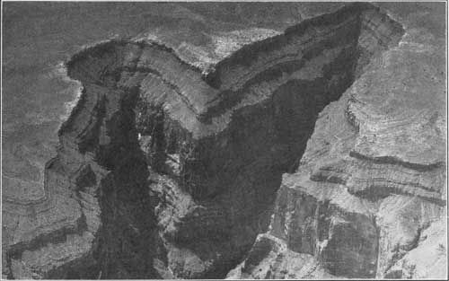
PLATE XV. LOOKING
INTO GRAND CANYON FROM THE AIR.
In the upper left-hand corner appears the even surface of hard rock at the top of the plateau in which the canyon is eroded. Below the rim appear the slopes of soft rock and the cliffs of hard rock. Official photograph U. S. Army Air Service. |
In time, when the nucleus had grown by accretion or the addition of solid particles to something like one-tenth of the present mass of the earth, it began to gather an atmosphere, because then its attractive force was able to hold the gases. The moon (1/81 of the earth's mass) has no atmosphere, but Mars (about 1/9 of the earth's mass) has a thin atmosphere.
When the growing earth had become large enough to hold by its attractive force the swiftly moving particles of oxygen, nitrogen, and water vapor, and prevent them from escaping into space, these gases began to accumulate and form an atmosphere. The heavy gases of slow movement, such as carbonic acid gas, may have been captured first; the lighter and swifter ones later, when the earth was larger and had greater attractive force. But the earth is not large enough yet to capture and hold hydrogen and helium, although it might hold these gases in its atmosphere should it grow sufficiently large, for these gases exist in the atmosphere of the sun.
The rocks, cold at first, may have been heated by impact in the fall of the planetesimals, by compression, by internal friction of the compressed masses under gravitative force, or by other processes, less easily understood. Probably it cannot be proved that no large part of the earth was ever molten at one time, but the fact that it is now as solid as steel harmonizes with the belief that the earth has never been a molten globe and that it has never possessed the high temperatures at the surface which the nebular hypothesis demands.
When the atmosphere had gathered enough water vapor to become saturated, precipitation began. Previous to this time there were no streams, lakes, or seas. The rain water falling on the surface naturally dissolved the more soluble material and carried it in solution into the depressions of the earth's surface, just as it does today. Also, just as today, the water evaporated, leaving the soluble salts in the basins. Thus the hollows at first held fresh-water lakes, which gradually increased in volume and salinity through uncounted ages until they became great briny oceans.
If this process began when the earth was only as large as Mars its outer shell, about 1900 miles thick, grew up in the presence of water, and to the salinity of the ocean nine tenths of the earth's mass has contributed part of its soluble matter. In this connection also it may be noted that in place of a universal ocean, which, according to the older belief, covered the face of the earth, the newer notion postulates universal land, from the higher parts of which streams washed rock débris into basins that finally became filled with lakes and seas. Also under the newer hypothesis there is no reason for believing that the climate of these very early stages in the development of the earth was greatly different from that of later time.
|
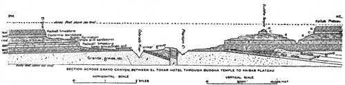
| FIGURE 1. Profile section across Grand Canyon west of Bright Angel Creek from El Tovar to Kaibab Plateau (after N. H. Darton). (click on image for a PDF version) |
The succession of events in the growth of the earth, as stated, gives no grounds for supposing that living beings could not exist very early in its history. Some of the oldest forms of life known (the crustaceans whose fossil remains are obtained from rocks of Algonkian age) stand relatively high in the scale of animal life. Living beings must have existed for long ages in order to be developed into animals of the high order of these crustaceans. The observed facts demand conditions favorable to life for a long time prior to the Algonkian period, and the succession of events just outlined indicates that such conditions may have prevailed during the period represented by the Archean rocks at the bottom of Grand Canyon.
The plainly defined line of unconformity between the rocks of Archean age and those next younger in the walls of Grand Canyon—separating the Unkar from the underlying granite and gneiss—is shown in Figure 1. This unconformity represents a long period of erosion, during which the region was reduced to a nearly level plain.
The Algonkian Period
This Archean plain was submerged and covered by sediments, deposited chiefly in water. The epoch of deposition continued until the sediments had in some places gathered to a thickness of about 12,000 feet. In other places, however, the surface was above water and was being worn down to supply these sediments. Some of the material is coarse and may have been deposited along streams; some of it is fine and was deposited as mud in shallow water; and some is limestone, which probably accumulated when the site of Grand Canyon was beneath the sea.
These rocks differ in character and appearance from the younger rocks which overlie them. They are changed or metamorphosed. When they were deposited as sediments they did not differ from the sand, mud, and limy ooze which are being deposited at the present time. But through the long ages that have elapsed they have been subjected to pressure and heat. They have been fractured, and molten rock has been forced into them. They have begun the change by which they may at some time in the future attain the crystallne condition of the Archean rocks beneath them.
Algonkian Glaciers
Little is known of the climate of Algonkian time, for the climate of a geologic period must be judged chiefly by its fossils. The living beings of Algonkian time consisted mainly of low types of marine animals and plants, such as seaweeds and worms, and relatively little is known of them.
But there is some convincing evidence concerning the Algonkian climate. Certain deposits indicate the presence of glaciers in Algonkian time, perhaps during more than one epoch, for the period was a long and varied one. Evidences of Algonkian glaciation have been found in Canada, Australia, India, China, South Africa, Europe, and elsewhere. Hence there is good reason for believing that the climate during this period was not greatly different from that of later time, and that instead of sweltering in a murky atmosphere of steam and heated gas, as some have supposed, the earth seems to have been colder on the average than now. Even in some equatorial regions it was clothed in ice during parts of this very early period.
After the deposition of the Grand Canyon series of strata there was extensive uplift and disturbance of the rocks, during which the material originally laid down in horizontal sheets was warped and tilted and broken into blocks. These blocks were faulted or moved out of place and the whole disturbed mass was eroded until at some places the Algonkian rocks were entirely swept away. At other places certain parts of them were preserved by being depressed below the level where erosion is possible, and some low hills were left where unusually hard rock cropped out.
|
|
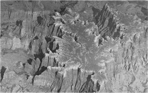
PLATE XVI. EROSION
FORMS IN THE GRAND CANYON DISTRICT AS SEEN FROM AN AIRPLANE. VIEW NEAR
THE HOPI INDIAN RESERVATION, ON LITTLE COLORADO RIVER.
The photograph shows the buttes and mesas of the arid West. Official photograph U.S. Army Air Service 53781. |
This series of events is known collectively as the Grand Canyon revolution. If the process of erosion by which the Grand Canyon was formed should continue until the river had swept away the whole plateau and formed a plain near sea level where the mile-high mesas now stand, the work accomplished would be less than that performed during the period of erosion which followed the Algonkian, for a thickness of more than 12,000 feet of rock was removed at that time.
Length of Algonkian Time
This great length of time, which has been regarded by some geologists as equal in duration to that of the ten great geologic periods ranging from Cambrian to the present day, is represented in some places in the canyon walls by a single line. Where the older rocks were tilted before they were eroded and covered with younger sediments the line represents what is called an angular unconformity, because the bedding planes of the older rocks meet those of the younger at an angle, as shown in the sections in Figure 1, such as that between the Unkar and the overlying shale. Where no angularity is apparent the line represents what is called an unconformity by erosion. In either case the line marks a break in deposition covering a period of time not represented by sedimentary rocks. It represents a period when records were being destroyed by the wasting away of the rock. Records of some of the periods unrecorded here are found in other parts of the world, for the rocks torn from the highlands in one place must find rest in some other place. But during the post-Algonkian period of erosion the continental areas of the whole world seem to have been high, so that the unconformity appears to be world-wide. This hiatus or break in recorded time is the greatest known, unless it is exceeded by that represented by the erosional unconformity between the Archean and Algonkian. Thus the two greatest unconformities in the world are represented in Grand Canyon, and both merge into a single unconformity at the base of the Tonto group, where the rocks of this group rest on the granite.
The Cambrian Period
The Cambrian is one of the long periods in the life of the earth and may be compared to a year in the life of man. The name was given by geologists to rocks that were first studied in Wales, a country known to the Romans as Cambria. Later, when it was learned that rocks were formed in other countries at the same time, the name Cambrian was applied to them also.
The Archean has been likened to the prehistoric age of human history, comparable in a sense to the old stone age, and the Algonkian to the legendary age, comparable to the period of Greek mythology. With the Cambrian period, represented by the Tonto group of the Grand Canyon, begins the stage of well-recorded geologic history. To carry the simile a step farther, this new era, like many in human history, began with a revolution called the Grand Canyon revolution. It is a modern era in earth history, for the Cambrian is said to date back only about a hundred million years, whereas the preceding periods date back infinitely farther.
There may have been some land plants of low order at this time, but the known plants of the Cambrian period are algae or seaweeds. Although little is known of Cambrian plant life it must have been abundant, for animals depend on plants for food, and the animals of Cambrian time were numerous. They were low in the scale of life and were sea dwellers. No remains of land animals have been found and no vertebrates, even of the lowest type. Thus at the time the Tonto beds of Grand Canyon were forming there were sea worms, mollusks, sponges, and several low forms of life that were wholly unlike any now living. Some of these were preserved as fossils.
Fossils and History
Fossils are the symbols in which the history of the world's life is written, and a knowledge of the symbols is necessary before the story can be read. Animals and plants that lived long ago were buried in mud just as those of today are being so buried in some places. The mud hardened to rock and was covered in turn by other layers of mud. Some of these layers were lifted and eroded when the mountains were pushed up, exposing again the remains of the buried animals and plants. These remains are the characters in which some of the story of the earth is written. But the language must be known before the story can be translated.
If you look carefully at the shell of a living oyster you will observe certain definite features. You could not mistake it for anything else. Many things have been learned about the habits and life of this oyster. In some places it thrives; in others it cannot live. It is at home in a sheltered bay where the great waves of the ocean cannot disturb it, but is not happy in deep water far from shore. It cannot live long in fresh water and is happiest where the water is not so salty as in the open ocean.
If now we compare this shell with a fossil oyster shell we see that the two are similar. The one was found in Chesapeake Bay, the other in solid rock perhaps a mile above sea level and a thousand miles from any place where an oyster could now live, yet there is no doubt that the fossil is the shell of an oyster, and there should be no question that oysters thrive only in bodies of water connected with the sea.
Records in Stone
The fossil oyster shell tells us just as plainly as if the story were written in words that the place where it was found was once a mile lower than it is now and that the sea once occupied the region where it was found. It is evident also that in that olden time the streams were carrying sand and mud into the sea just as they are carrying them into the sea in our day. The mud hardened into rock, and this rock, once at the bottom of the sea, was in time pushed up with others to form mountains.
Nature not only wrote her story in plain language, but she arranged it in regular order, so that it can be divided into what we may call chapters. These are the geologic ages, such as the Cambrian. But although a complete story was written, not all parts of it can be found in any one place. Some can be found only in Europe, others only in America; some can be read only in the frozen lands of the Eskimo, others only in the Tropics. Not all of its parts have been found. Some may yet be recovered, but others may not, for the agents of destruction have been as busy in the past as they are in the present, and, they have destroyed many records.
The rocks seen in the canyon walls above the Tonto group are of Devonian and Carboniferous age. They are younger than those of the Tonto formation by many millions of years. This long stretch of time, here unrecorded by deposition, is marked in the canyon walls by an unconformity. This unconformity differs from that found below the rocks of Cambrian age in two significant ways. The Tonto beds were not planed off, nor were they entirely removed at any place that is now exposed. The canyon region may have been above sea level during the time represented by the unconformity and may have received no sediments; or sedimentary rocks may have been formed here and later eroded away. However this may be, it is evident that the Cambrian rocks in this region were not crumpled up into mountains and that they were not raised far above sea level, otherwise they would have been deeply eroded or entirely removed.
Evidently the region lay low throughout all the time between the end of the Cambrian period and the beginning of the Carboniferous; in other words, the Ordovician and Silurian periods are not represented, and the Devonian is represented only in part, by thin beds, which are not readily distinguished from the overlying rocks.
The Carboniferous Period
Next above the Devonian and resting on it, or on the Cambrian rocks where the Devonian is absent, is a great layer of limestone, which is about 600 feet thick in the southern part of the canyon region and much thicker farther north. This limestone is harder than the rocks above and below it and has resisted erosion more strongly than they. It crops out midway in the canyon walls, where it forms bold, red promontories. Because of its color and the wall-like face of the cliffs it is called the Redwall limestone. It forms prominent cliffs in Cheops Pyramid and in several of the so-called temples, many of which are familiar to visitors in Grand Canyon National Park.
The Sea and Grand Canyon
Although the wall formed by this limestone is red, the rock itself is light blue or gray. Its color is due chiefly to wash from the red shale and sandstone above. This limestone contains fossil shells of sea animals and these fossils tell us that the Grand Canyon region, which had been above sea level during much of the time since the Cambrian period, subsided during the Carboniferous and was covered with sea water.
During the early part of the period represented by the Redwall limestone, sea water covered broad areas of the interior part of North America. Later in the period, although there was an open sea in the Grand Canyon region, broad swamps formed at many places in the interior of North America, and in these swamps accumulated the vegetable matter which formed the Carboniferous coal. Rocks of this age, both in America and in other continents, contain quantities of coal so vast that they are often called the Coal Measures. The name Carboniferous was suggested by the carbon of the coal.
The rocks above the Redwall limestone, the Supai red beds, 1,400 feet thick; the Coconino sandstone, 300 feet thick, which outcrops high in the canyon walls and which usually forms a nearly vertical cliff; and the Kaibab limestone, 600 feet thick, which forms the rim of the canyon in the National Park, were formed late in Carboniferous time.
Through geologic work in the canyon country we are continually learning more about the rocks in which the canyon is carved. It is now known that the beds formerly called Supai consist of two parts separated by an unconformity and the name Supai is today restricted to the lower part. The upper part is called the Hermit shale and is classed with the Coconino sandstone and the Kaibab limestone as Permian. But as this subdivision is likely to interest few besides professional geologists the older usage is here allowed to stand.
This series of rocks is clearly and beautifully exposed in the southern part of the canyon region, but it is not so clearly exposed in some other parts. North of Marble Canyon it is difficult to identify some of these formations. Parties sent out in recent years by the United States Geological Survey have obtained valuable additional information, which, however, has not yet been published, hence the old nomenclature is presented here.
PRINCIPAL DIVISIONS OF GEOLOGIC TIME.a
| Era | Period | Epoch | Characteristic life |
| Cenozoic (recent life) | Quaternary | Recent Pleistocene (Great Ice Age) |
"Age of man." Animals and plants of modern types. |
| Tertiary | Pliocene Miocene Oligocene Eocene |
"Age of mammals." Possible first appearance of man. Rise and development of highest orders of plants. | |
| Mesozoic (intermediate life) | Cretaceous | (b) | "Age of reptiles." Rise and culmination of huge land reptiles (dinosaurs), of shell-fish with complexly partitioned coiled shells (ammonites), and of great flying reptiles. First appearance (in Jurassic) of birds and mammals; of cycads, an order of palmlike plants (in Triassic); and of angiospermous plants, among which are palms and hardwood trees (in Cretaceous). |
| Jurassic | (b) | ||
| Triassic | (b) | ||
| Paleozoic (old life) |
Carboniferous | Permian | "Age of amphibians." Dominance of club mosses (lyre pods) and plants of horsetail and fern types. Primitive flowering plants and earliest cone-bearing trees. Beginnings of backboned land animals (land vertebrates). Insects. Animals with nautilus-like coiled shells (ammonites) and sharks abundant. |
| Pennsylvanian | |||
| Mississippian | |||
| Devonian | (b) | "Age of fishes." Shellfish (mollusks) also abundant. Rise of amphibians and land plants. | |
| Silurian | (b) | Shell-forming sea animals dominant, especially those related to the nautilus (cephalopods). Rise and culmination of the marine animals sometimes known as sea lilies (crinoids) and of giant scorpion-like crustaceans (eurypterids). Rise of fishes and of reef-building corals. | |
| Ordovician | (b) | Shell-forming sea animals abundant, especially cephalopods and mollusk-like brachiopods. Culmination of the buglike marine crustaceans known as trilobites. First trace of insect life. | |
| Cambrian | (b) | Trilobites and brachiopods most characteristic animals. Seaweeds (algae) abundant. No trace of land animals found. | |
| Proterozoic (primordial life) |
Algonkian | (b) | First life that has left distinct record. Crustaceans, brachiopods, and seaweeds. |
| Archean | Crystalline rocks | No fossils found. |
aMany of the time divisions shown above are separated by unconformities—that is, the dividing lines in the table represent local or widespread uplifts or depressions of the earth's surface.
bEpoch names omitted; in less common use than those given.
Carboniferous Life
The first animals lived in the sea. But in Carboniferous time the higher forms of life became air breathers and lived on land. It has aptly been said that during this period life rose from the sea and took possession of the land. Little is known of the land forms of earlier ages, but the broad lowlands and swamps of Carboniferous time were favorable to the growth of land plants and to the development of animals that subsist on such plants.
The trees were altogether different from those of the present day (Plate XXI). There were among them some cycads—a type that culminated in a later age—and some conifers. There were also giant reeds called Calamites, and the ferns of that day grew to be large trees. But the dominant forest trees of Carboniferous time have no living representatives, hence no common name. There was Lepidodendron, a great tree that began life in an earlier geologic age and died out in the Permian epoch, at the end of the Carboniferous period. Some of these trees grew to be 100 feet in height and 3 or 4 feet in diameter. Their great pithy trunks of porous material—it can not properly be called wood—forking into a few prongs, were clothed with small evergreen leaves. Another common tree of this time is Sigillaria, distinguishable from Lepidodendron by parallel rows of leaf scars that ran straight up the fluted trunk, for those of Lepidodendron ran in spirals around the trunk.
With the lower orders of plants came the lower orders of insects, such as spiders, dragon-flies, and beetles, but no bees or ants, for there were no flowering plants, on which the higher insects live. About a thousand species of Carboniferous insects have been found, half of which are cockroaches. They may have been as harmless as their repulsive descendants, but we may give a sigh of relief and a smile of complacent satisfaction with present conditions when we reflect that some of the Carboniferous cockroaches were 4 inches long. We may also feel the same sense of relief in respect to the other insects, some of which, such as the dragon-fly, had a spread of wing of more than 2 feet.
Rise of Animals from Water to Land
The amphibians, which are sometimes defined as those vertebrates which made the transition from aquatic to terrestrial life, began at an early stage in the history of life and developed into true air-breathers. Their evolution during long ages is reproduced in miniature in the individual development of modern amphibians, such as toads and frogs, which begin life as purely aquatic gill-breathing creatures and later become air-breathers. The amphibians and the reptiles, which began their existence in Coal Measures time, were the most highly developed beings of that age. They were very different from the living forms, and some of them were as large as crocodiles. The development of these air-breathing vertebrates is regarded as the most important event in the whole progress of evolution, for it represents the rise of animal life out of the water. From the Carboniferous period to the present time the air-breathers have been the dominant forms of living creatures.
The climate of the Coal Measures period seems to have been warm and moist, and the growing season seems to have lasted the year round. Coal beds on the Antarctic continent and also far to the north, as well as coral reefs in Spitzbergen, indicate that a warm climate then extended nearly to both poles. A picture of the monotonous Carboniferous landscape is drawn by Charles Schuchert as follows:
In these forests of Pennsylvanian time might have been seen flying about the largest insects that have ever lived,—great dragonflies reaching a wing spread of over 2 feet. Huge cockroaches abounded everywhere in great variety, giants of four inches in length not being rare. As a rule these insects were Carnivorous and did not transfer the pollen from one flower to another, as is so commonly done by living insects among present-day plants. The smaller forms were preyed upon by scorpions or spiders, the latter not making webs but living on the ground or in rotten logs along with many myriapods or thousand-legs. No insect of this kind, so far as known, produced chirping or other sounds and the soughing of the wind among the trees was possibly rarely interrupted, save by the croak of an amphibian in the marsh. Reptiles and amphibians were common in the swamps, and it is probable that many small reptiles were running over the ground and about the trees. No large land animals such as we know and no birds were to be seen.
Most of the rocks of Carboniferous age in the Grand Canyon were formed in water, but in many parts of the world rocks of this age contain beds of coal, which renders appropriate the name Carboniferous.
While the limy ooze was gathering in the sea in northern Arizona, broad swamps were forming at many places in central and eastern North America and in many other parts of the world. In these swamps accumulated the vegetable matter which formed the coal of this age.
The Formation of Coal
Most of the coal now used in America is mined in the eastern and central fields, or between Pennsylvania and Kansas, where, in an area of 214,686 square miles, the coal stored in beds thick enough for mining and near enough to the surface to be reached in mines has been estimated at 1,142,340,000,000 tons. If the coal of all the geologic ages should be included in the estimate the United States has 496,776 square miles of coal land and a supply of 3,157,243,000,000 tons.
Nearly all coal beds represent ancient swamps in which vegetable matter accumulated, as it does now, in standing water, where it partly decomposes to form muck and peat. The peat undergoes certain changes, is packed or consolidated by the weight of the sediments that gather on it, and becomes lignite, a soft near-coal whose woody character may easily be distinguished. The process by which peat is changed through lignite and bituminous coal to anthracite and finally to graphite is somewhat similar to the production of coke from coal, by which some constituents are converted into gas and driven off, leaving much of the carbon in the form called coke. This change of peat to anthracite may be caused by natural heat, but in many places it seems to have been caused rather by pressure and warping of the rocks, together, perhaps, with such heat as was caused by this warping.
A Measure of Geologic Time
The rate of accumulation of carboniferous material has been made the basis for computing the age of the rocks which contain the coal. It has been estimated1 that under the best conditions enough vegetable matter may be produced on a tract of land in about 300 years to make a coal bed one foot thick covering the same tract, provided none of it is lost. On the assumption that coal was produced in Carboniferous time at the same rate, the accumulation of the maximum thickness of 300 feet of coal in the Appalachian basin required 90,000 years. Naturally the rate of plant growth during the Carboniferous period is not known, nor is it known what proportion of the plants decayed at the surface or for any other reason was not included in the mass that was buried and turned to coal. But the figures seem to indicate that probably much more than 90,000 years was consumed in forming the beds of coal. This takes no account of the time required for the accumulation of the thousands of feet of sedimentary rock in which the coal was embedded.
1Ashley, Geo. H., Economic Geology, p. 47, 1907.
Another way of arriving at the approximate length of a geologic period is by the rate of accumulation of rock material. Some geologists have estimated that in regions where coral reefs abound limy mud (calcium carbonate) may accumulate at such a rate that a foot of limestone would be formed in 200 years. In regions where calcium carbonate is precipitated chemically, with little aid from organisms, its accumulation may be very much slower, possibly less than a foot in 1,000 years. This rate may be used in illustrating the method of reaching an approximation of geologic time but should not be used as if based on a secure foundation. If the Redwall limestone was formed at this rate, the thickness of 600 feet represents 600,000 years. Its massive nature and the scarcity of fossils in it suggests slow accumulation and correspondingly long time.
Several methods have been used to reach a measure of geologic time. The most recent one is based on radio-activity, and this method indicates surprising lengths of time. On this subject Dr. W. H. McNairn1 says:
Among those elements which are known to undergo the mysterious change due to disintegration of the atom is uranium. By giving off particles of helium at a constant and definite rate, uranium is believed to pass over into radium and lead. If in any given uranium-bearing mineral we can determine the relative proportions of uranium, radium, and helium, and lead if it is present, knowing the rate at which these changes take place, we should be able to determine the age of the mineral itself.
This method, first Suggested by Sir Ernest Rutherford in 1906, was subsequently made good by the Honorable R. J. Strutt. His results were somewhat startling in the unexpectedly great periods of time which they indicated. For instance, he allotted the very respectable antiquity of 141,000,000 years to some rocks which were found about half-way down to the earliest fossiliferous deposits. However, these first figures were not uniform. Of recent years these have been tabulated and indicate a certain amount of consistency, particularly in their unanimity in extending the reach of geological time to an extent undreamed of by the geologists. Who, for example, would have dared to suggest, from geological evidence alone, that we have to do with periods of from 800 to 1,600 million years?
1McNairn, W. H., The Scientific American Supplement, April 19, 1919.
The Permian Epoch
The Permian epoch takes its name from the province of Perm, in the Ural Mountain region of eastern Russia, where the rocks of the youngest division of the Carboniferous system were first studied by Murchison, an English geologist, and named in honor of that province.
Late in Carboniferous time, probably at the beginning of the Permian epoch, some condition arose that caused world-wide changes. In some parts of the world mountains were formed, but in the Canyon country the land was raised but little out of the sea and was not greatly disturbed.
Thick beds of sand accumulated on the low-lying area. In some places these accumulations attained a thickness of more than a thousand feet. Then the sea returned and covered the sand with limy ooze. In time these deposits hardened into the rock formations known to geologists as the Coconino sandstone and the Kaibab limestone. These are the rocks of the precipitous cliffs at the rim of the canyon. In other parts of the plateau country the rocks of this age have a different aspect.
Probably the most notable scenic objects formed by the sandstones of Permian age are the natural bridges in eastern Utah. As these are among the most remarkable of known bridges, let us take a side trip and see them before we consider the landscapes of Permian time.
Natural Bridges
The natural bridges in White Canyon, Utah, first made known to the general public in 1904, were proclaimed a national monument in 1908. In this monument there are three bridges of great size and beauty. The largest is called Augusta by some and Sipapu (portal of life) by others; the smallest is the Edwin or Owanchomo (rock mound) (Plate XVII); and the third is called Caroline or Kachina (guardian spirit). The Indian name was suggested by a symbol carved on the bridge and recognized as that of the Kachina, the sacred dancers of the Hopi Indians.
These great bridges consist of white sandstone of Carboniferous age and were formed by erosion when White Canyon and its tributary, Armstrong Canyon, were cut. The smallest, and probably the oldest of the group, was formed in Armstrong Canyon about 3 miles above its junction with White Canyon. Here a narrow ridge was left between Armstrong Creek and an unnamed tributary. The two streams undercut this dividing ridge from opposite sides until they met under the upper part of the ridge, which was left as a bridge. The larger stream captured the smaller, leading the captive underneath the newly formed arch. Since the time of this stream piracy each channel has been cut far below the level of the ancient stream bed. The beam of rock which now bridges the captured stream is slowly weathering away but is still 10 feet thick and 35 feet wide in its narrowest part. It spans the unnamed valley 108 feet above the stream bed, the slender, graceful strip of rock being supported by abutments 194 feet apart. The dimensions here used for these bridges are those furnished by the National Park Service.
The Caroline bridge (Plate XVIII) was formed in a somewhat different manner. Long ago the stream that cut White Canyon at its junction with Armstrong Canyon flowed in a sinuous or meandering course, which it maintained as it cut downward into the white sandstone and thus formed what is known technically as an intrenched meander. Here it made a horseshoe-shaped gorge around a peninsula or mass of rock that is connected with the main wall by a narrow neck. As erosion proceeded the stream in White Canyon impinged against the rocks of this neck and undercut them. From the opposite side the same stream, aided by Armstrong Creek, which joins White Creek at this point, undercut the neck until a hole was formed through which White Creek took a short cut, abandoning the longer course around the peninsula. The upper part of the neck now forms Caroline bridge.
Caroline bridge is the youngest and most massive of the White Canyon group of bridges. It is rough-hewn, having the appearance of vigorous youth and giving the impression of great strength and endurance. Huge blocks of rock fallen from the walls suggest that the master workman was interrupted before his task was finished. Great masses of rocks, weighing tons, still hang to the wall from which nature chiseled them.
According to the National Park Service, Caroline bridge stands 205 feet above the bed of the stream it spans, and it springs from abutments 186 feet apart. The arch is reported to be 49 feet wide and to have a minimum thickness of 107 feet.
Augusta bridge (Plate XIX) stands in White Canyon 2-1/2 miles above its junction with Armstrong Canyon. It is an enormous arch of white sandstone, whose abutments stand 261 feet apart. The great stone beam, 65 feet thick and 128 feet wide in its smallest part, spans the stream at a height of 222 feet above the water.
This wonderful piece of nature's handiwork, so perfectly carved and so symmetrically proportioned that it is difficult to realize its size, is set in the midst of a group of impressive rock forms. The canyon walls, which are formed of barren white sandstone, are high, steep, and rugged, and rise sheer from the narrow bed of the creek. In almost inaccessible nooks high in these walls may be seen cliff dwellings. Some of these dwellings, reminders of the ancient race of human beings which once flourished here but finally vanished, have never since been entered. The charm of mystery still lingers about them.
The modern Indians, who are supposed to be the descendants of the cliff dwellers, believe that they come into the world from a lower region through an opening which the Hopis call Sipapu—the door of life. After death they return through the same hole to the nether region, there to dwell for a time before mounting to the sky to become "rain-gods."
These bridges are far from ordinary routes of travel, and few people have seen them. One result of this isolation is their unmolested, clean appearance. The walls have not been marred by initials carved in the stone, nor have messages of the zealot or the advertiser been painted or smoked on the smooth faces of the rock. Some who have visited places of interest that were popular long ago and have seen the thousands of names and dates that disfigure the walls experience a thrill of delight as they read the notice posted at the camping place under Caroline bridge, which states in no uncertain words that name scratching is positively forbidden.
These natural bridges are the result of normal stream erosion in an elevated region. There is no mystery about them. Doubtless thousands of similar bridges have been formed and destroyed in ages past and other thousands will be made and later destroyed in ages to come.
The great sandstone of which they are made was formed long ago near sea level and was later covered by other beds of sediment many thousands of feet thick. Some of these rocks were formed by deposition in the sea after the white sandstone had been depressed far below sea level.
After being buried for uncounted eons, this sandstone, in common with other rocks of the plateau region, was raised and its elevated surface was exposed to erosion. Then, as now, the rain formed rills and the water of the rills gathered into rivulets and finally into rivers. These sought the lowest places on the surface in their way to the sea, just as they do at the present time.
Probably the elevation was slow and the rate of rise of the surface differed from place to place. Where the rise was slow enough broad, shallow valleys were eroded. Where the rise was relatively rapid deep, narrow canyons were cut. Also where the streams were flowing over soft rocks they tended to form broad valleys, and where they were flowing over hard rocks they tended to form narrow valleys.
Furthermore, the rate of elevation of the rocks varied from time to time. During a time of slow upward movement, or even of cessation of such movement, the streams tended to broaden their valleys and to meander widely over the evenly graded bottom lands.
These principles may be applied in picturing the formation of White Canyon. As the surface rose higher and higher the waters of the higher lands formed streams. These streams cut their channels deeper and eroded away the rocks at their sides, just as the streams do now. During the long ages in which this elevation and erosion were going on a thickness of thou sands of feet of rock was removed from the plateau region.
In the course of its down-cutting the little stream which carved White Canyon meandered widely, carrying away the soft material of the red rocks that once covered the white sandstone. But when in its downward course it reached this hard sandstone it found erosion more difficult. But its meandering course was established and it cut its trench into the sandstone along this course. It continued its lateral cutting but made little headway toward broadening its canyon in the hard rock. Thus were formed the intrenched meanders, such as those at Caroline and Augusta bridges.
At Augusta bridge and at Caroline bridge the stream in its meandering course formed a loop resembling an ox-bow, flowing about a peninsula of rock that had a narrow neck. This neck was at the point where the stream was obliged to turn sharply in order to flow around the end of the peninsula. Also, on its return to the other side of the neck, it made a sharp turn in the opposite direction. It is the law of streams that they cut their banks on the outer side of curves. Thus the neck of the peninsula was undermined by the floods that surged against it from both sides. In time they broke through the neck and took the short cut through the hole thus formed. The end of the peninsula was left as an island, and the upper part of the neck remains as a bridge binding this island to the mainland.
Permian Landscapes
Returning now from our side trip, we may bring to an end our consideration of the Carboniferous period by mentioning the outstanding characteristic of this closing epoch of Carboniferous time. In order to picture the Permian landscape we must go far afield, for the rocks of Permian age are known more intimately in other parts of the world than in America.
The equable climate of Coal Measures time, which was so mild the world over that the epoch may be called one of universal summer, was changed in a most remarkable manner. The Permian epoch, which followed, seems to have been one of almost universal winter, for glaciers formed in some places practically at the equator. The material left by glacial ice in Permian time is found in India, Australia, Africa, Brazil, Canada, and other countries.
The change from low, swampy lands having a uniform, warm climate to a mountainous country having a cold, variable climate caused corresponding changes in the plants and animals. The changes, however, were not sudden. They extended over a period of time measured probably in hundreds of thousands or perhaps millions of years. Two conspicuous results were the development of cold-climate plants and of highly organized reptiles.
The Permian reptiles in all parts of the world seem to have had unusually strange characteristics. One of the lizard-like creatures from Brazil had a tail as long as its body proper, with a notable enlargement in the middle of it. The Permian reptiles whose remains are found in South Africa were large, clumsy creatures with bones so massive and so curiously shaped that they have been called "reptilian bone-piles." But probably the most peculiar creature of all is the finback lizard, shown in Plate XXI, B, whose remains are found in Texas. The so-called fin was produced by elongated spines half as long as the body. Many varieties of these strange creatures have been found, ranging in length from 3 to 10 feet.
| <<< Previous | <<< Contents>>> | Next >>> |
stories_in_stone/chap4.htm
Last Updated: 31-Dec-2009