|
SHENANDOAH
General Information Regarding Shenandoah National Park Project, Virginia ca. 1933 |

|
SHENANDOAH NATIONAL PARK PROJECT
In the Blue Ridge Mountains of Virginia
A national park in the Virginia section of the Blue Ridge Mountains was authorized by an act of Congress approv ed May 22, 1926. The act specified that when title to 250,000 acres of a tract of land approved by the Secretary of the Interior should be vested in the United States, it would constitute a national park dedicated and set apart for the benefit and enjoyment of the people, and the Government would proceed with the installation of accommodations for visitors, the development of an adequate road and trail system, the stocking of fishing streams, and the inauguration of an educational service to acquaint the public with the historical back ground and natural beauty of this famous region.
Upon the passage of the act, the State of Virginia, through its Commission on Conservation and Development, immediately began the work of acquiring the money to purchase the necessary land. This was a tremendous undertaking as the approved area was made up of thousands of parcels of privately owned land. Funds were raised through State appropriations, contributions from citizens of Virginia, and from outside sources. The work moved forward with all possible expediency until the period of general depression set in, and it became increasingly difficult to obtain funds.
In 1932 Congress authorized the reduction of the minimum acreage from the 250,000 acres stipulated in 1926 to 160,000 acres. The State of Virginia is acquiring title to this land as rapidly as possible, and as soon as it is obtained, the entire tract will be presented to the Federal Government. The Office of National Parks, Buildings, and Reservations of the Department of the Interior will then begin development of the area in accordance with the system followed in the great national parks of the West, and the park will be formally opened to the public.
Construction of the Skyline Drive, a spectacular scenic highway along the crest of the mountain range, was begun in 1931 with appropriations made available for use in the national parks by the Emergency Construction Act of that year, A 32-mile section between Thornton and Swift Run Gaps, connecting with the Lee Highway at the former place and the Spotswood Trail at the latter, has been completed. When the plans for this road are eventually carried out, it will extend from Front Royal to Waynesboro. Emergency conservation labor is being used to build guard rails along the completed section of the highway, and to carry on a program of blister rust control to protect the forests. A program of general clean-up to reduce fire hazards affecting more than 15,000 acres of forest is also under way. Nearly 35 miles of roadside are being improved and many miles of trails cleared. This preliminary improvement work, made possible by the President's emergency conservation program, is an important contribution to the development of the park, and will hasten its availability for general public use when the land is finally turned over to the Government.
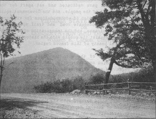
Hawksbill from the Skyline Drive
GEOLOGY*
*By Arthur Bevan, State Geologist of Virginia.
The Shenandoah National Park area and its environs afford an excellent opportunity to see and study geologic records in part of the Appalachian Mountains. Each scenic feature and each outcrop of rock is in a real sense a manuscript record of some interesting geologic events, whose succession has produced the present landscapes in the Park area.
The general region lies in three well-defined geologic and geographic provinces. The Park area is part of the northern Blue Ridge, characterized by a high ridge from which branch numerous sharp spur ridges that alternate with deep narrow valleys, or "coves." The general altitude of the summit areas is about 3,000 to 3,500 feet. Hawksbill and Stony Man are the highest peaks in northern Virginia, being 4,049 and 4.010 feet, respectively, above sea-level. Several important gaps, or shallow passes, such as Swift Run Gap and Thornton Gap, occur at intervals along the crest of the Blue Ridge.
To the east is the Piedmont province, a flattish region which slopes gently toward the Atlantic Ocean. The altitude along its western margin is about 600 to 800 feet. This extensive plain has been dissected by streams which rise in the Park area. Numerous hills and short ridges, erosional outliers of the Blue Ridge, are scattered over its western part. West of the Park area is another broad undulatory plain, the floor of Shenandoah Valley. It slopes northward from an altitude of about 1,400 feet west of Waynesboro to 400 feet at Potomac River. The valley is 20 to 25 miles wide. It is bisected between Elkton and Strasburg by Massanutten Mountain, a group of long ridges that rises more than 1,500 feet above the valley floor. The valley east of this mountain is called Page Valley.
The rocks along the crest of the Blue Ridge are chiefly greenstone, or altered lavas flanked by coarsely crystalline, igneous rocks such as granite, along the east slope and by metamorphosed sedimentary rocks, mainly sandstone and quartzite, along the west slope. The western part of the Piedmont province is underlain principally by granitoid rocks. Limestones and shales underlie Shenandoah Valley. Massanutten Mountain is capped by firm sandstone.
All of the bedrock of the region has been highly folded. Some of the folds have been broken so that huge masses of rock have been shoved for miles northwestward along a great thrust fault. This is well shown between Luray and Front Royal, where the older crystalline rocks of the Blue Ridge have been thrust over the younger limestones in Shenandoah Valley.
In brief, the geologic history of the region has been as follows: In remote geologic periods (pre-Cambrian) great bodies of molten rock invaded unknown older rocks and upon cooling crystallized into the granitoid rocks. Some of the molten material poured out upon the surface to form the greenstone lavas. Subsequently (Paleozoic era) the region lay beneath a broad shallow mediterranean sea in which were deposited thousands of feet of sediments. The sands, muds, and limy muds were consolidated into the sandstones, shales, and limestones which now occur in the Valley and which formerly covered the Blue Ridge. Toward the close of this era the ancestral Appalachian Mountains were folded and faulted upward and westward under the urge of enormous pressure in the earth's crust. Through a long era of relative crustal stability the old mountains were eroded to a vast plain, or peneplain, close to sea-level. This plain was then uplifted vertically for a few thousand feet and the rejuvenated streams dissected it into ridges on the resistant rocks and valleys in the weaker rocks. Flattish remnants of the old peneplain are found along the summit of the Blue Ridge and the even crest of Massanutten Mountain. The broad surface of the Piedmont region and the Shenandoah Valley floor are younger peneplains which also have been uplifted and are being dissected into a new pattern of valleys and hills.
Historic Region
.The area selected for the Shenandoah National Park lies in the heart of one of the richest historical sections of the United States. It extends for a distance of approximately 65 miles along the crest of the Blue Ridge between Front Royal on the north and Waynesboro on the south. All the highways leading to it run through regions replete with reminders of the colorful and important part Virginia played in Colonial history and the conflict of 1861-65. The Spotswood Trail, from Gordonsville to Clifton Forge and Troutville, crosses the park area at Swift Run Gap where Virginia's famous Colonial Governor, Alexander Spotswood, and his Knights of the Golden Horse Shoe passed on their way to the Shenandoah Valley in 1716. This expedition opened up a route to the country beyond the mountains and played an important part in western settlement. To the west of the park lies the great Shenandoah Valley with the historic town of Winchester at its northern end. Here George Washington made his headquarters during the French and Indian Wars. In this region Jackson conducted his famous Valley Campaign in 1862, to be followed by the Campaign of Sheridan in 1864. Old military roads used by soldiers in the great military engagements that took place on both sides of the Blue Ridge may still be traced in the park area.
In the Piedmont section to the east of the park are many ancestral homes built by famous men of the Colonial period. The park lies partly in Albemarle County where Peter Jefferson built Shadwell about 1737. Here his illustrious son, Thomas, was born in 1743. Monticello Mountain, on which Thomas Jefferson built his famous mansion, overlooks the Shadwell Estate. A short distance from Charlottesville, George Rogers Clark, conqueror of the Northwest, was born in 1752. Many of the people living in remote sections of the Blue Ridge adjacent to this area are believed to be descendants of deserters from the British Army quartered around Charlottesville during the Revolutionary period.
For the convenience of motorists, the highways of Virginia have been carefully marked with two-faced metal markers, and the information on the markers supplemented by a book giving the inscriptions. If a motorist notes the number of a marker, he may turn to his book and read the inscription at his leisure. These booklets are distributed free by the Virginia State Commission on Conservation and Development at Richmond, Virginia, and are an invaluable aid to motorists in locating points of historic interest.
Trees, Flowers, and Birds
The Blue Ridge Mountains are known throughout the world for the beauty of the trees and wild flowers which grow on its slopes in great profusion. The variety of trees is endless. There are pines, hemlocks, cedars, hickories, birches, beeches, sycamores, locusts, maples, and oaks of nearly every kind. In the spring the lovely white blossoms of the dogwood are to be seen on every hand, and the mountain slopes flame with the purple-pink blossoms that cluster along the branches and twigs of the redbud. In the autumn these slopes are a blaze of color that is an annual source of wonderment to spectators, no matter how often they have seen it before. Sumner green becomes a great mass of rich color, with browns, reds, and yellows splashing the mountain sides in every direction.
Nature has been just as lavish with wild flowers as with trees in this region. Each month has its own special offering, from the delicate trailing arbutus of early spring to the asters and goldenrod of fall. June's contribution of mountain laurel is perhaps the most spectacular. Its great clusters of delicate blossoms are surrounded by shining green foliage of rare beauty. Violets, golden buttercups, trilliums, honeysuckle with its far-flung fragrance, several varieties of orchids, wild roses, white daisies, azaleas, and many other lovely species stud the flower fields.
This section of the Blue Ridge has long been a favorite haunt of bird lovers. Forty species have been noted in a brief walk around Skyland.
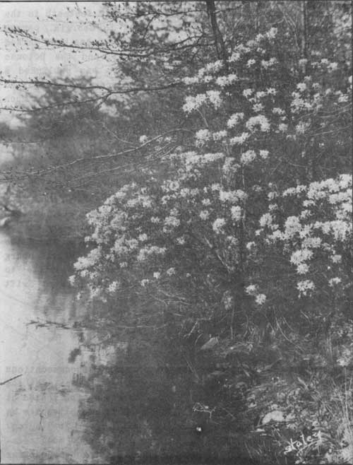 An azalea in full bloom—the pink blossoms are noted for their delicate beauty. |
The Appalachian Trail
The Appalachian Trail, a great mountain footpath in the Appalachian Range extending from Maine to Georgia, passes through the Shenandoah Park area. This trail has been marked by the hiking organizations sponsoring it, and the Potomac Appalachian Trail Club, Washington, D.C., has published a "Guide to Paths in the Blue Ridge" that contains a detailed description of the trail through the park region and much general information about the surrounding country.
The park area is within a short drive of Washington, Richmond, Charlottesville, Staunton, Harrisonburg, and Winchester. From Washington, the Lee Highway, No. 211, through Warrenton and Sperryville, crosses the park area by way of Panorama and joins the Valley Pike at New Market, where the pike leads north to Winchester and south through Harrisonburg to Staunton. The Spotswood Trail from Gordonsville to Harrisonburg crosses the southern end of the park at Swift Rum Gap. All roads are in good condition.
Accommodations
Skyland is a private resort providing accommodations within the park area. Separate bungalows with meals at the main building are available. Saddle horses may be rented at reasonable rates, and gas, oil, and smokers' supplies are on sale. Skyland is approximately 92 miles from Washington. The Mimslyn, a modern hotel at Luray, offers good accommodations at reasonable prices. Meals and limited accommodations may also be obtained at Panorama Inn at Thornton Gap.
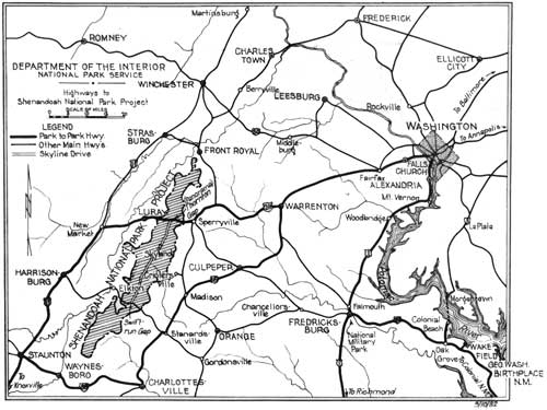
Map of Shenandoah National Park Project and Vicinity
(click on image for a PDF version)
| <<< Previous |
1933/sec1.htm
Last Updated: 20-Jun-2010