|
ROCKY MOUNTAIN
The Geologic Story of the Rocky Mountain National Park Colorado |

|
THE MAKING AND SHAPING OF THE MOUNTAINS.
GEOLOGY AND SCENERY.
The Rocky Mountain National Park is noted chiefly for variety of mountain landscape. The land forms result from the action of stream and frost and ice. A study of the park, therefore, is chiefly a study of geography. Furthermore, geographic development, or the shaping of the landscape is dependent on the character of the rocks; thus a knowledge of geology is needed to interpret the scenery. For this reason the geologist is appropriately called upon to describe the park. For the description it seems desirable to place our "once-upon-a-time" in the story of this park in a period before the present mountains had raised their heads above the sea.
BEFORE THE ROCKIES WERE BORN.
Over the place where Longs Peak and its slightly less imposing companions stand in lofty isolation and invite the summer tourist to their cool retreats, the waves of an open sea once rolled and its tide ebbed and flowed, unhindered by rock or shoal. In this sea sported the marine monsters of long ago and on its shores wandered the grotesque creatures of the Age of Reptiles (see table of geologic time, p. 20), which lived eons before the human race began its existence.
The mountain region has had a long and varied geologic history, which reaches back to a time long antedating the birth of the present mountains. Attention will be directed only briefly to this ancient geologic history, but, as older sedimentary rocks once covered the site of the mountains, brief mention will be made of some of the principal events. Older mountains have stood where the present Rocky Mountains now stand. From one of these ancient mountain systems were derived in the later part of the Carboniferous period, or Age of Amphibians, the sand and mud which hardened into the red rocks that form the conspicuous ridges or so-called hogbacks of the foothill region east of the park.
It may be of interest to some who pass through the canyons carved in these brilliantly colored rocks to know that the red beds were formed millions of years ago, before modern plants and animals came into existence. The landscape of that ancient day must have contrasted strongly with the present landscape. In place of the modern highly specialized plants the observer in retrospective imagination sees only the lower kinds of vegetable growth, such as horsetails, ferns, and the most primitive of the flowering plants. In place of the splendid forests (see Pl. III) which now cover the mountains he would see tree ferns and huge club mosses—great barren trunks each with a few huge leafless branches. In place of the higher mammals, such as the beaver, which the tourist may see if he has patience enough to wait for these cautious creatures to appear, the highest types of animals of that far-off time were the sluggish toadlike amphibians and the most primitive of reptiles.
|
|
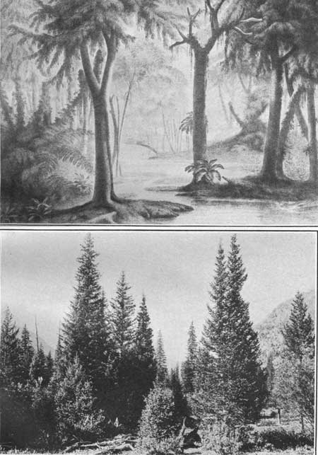
PLATE III. A (top). A CARBONIFEROUS LANDSCAPE.
Showing the great barren trunks of tree ferns and treelike club
mosses. B (bottom). A MODERN LANDSCAPE IN THE ROCKY MOUNTAIN NATIONAL PARK. Showing spruce and pine trees in the valley of the North Fork of Grand River. FORESTS OF YESTERDAY AND TO-DAY. Photograph by Willis T. Lee, United States Geological Survey. |
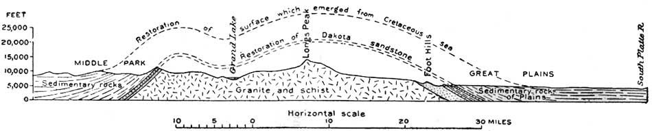
During long ages which followed the ancient mountains were worn down by rain and stream until a nearly flat surface extended over the region where the mountains had stood. To this plain the streams from the highlands of other regions brought sand and mud and spread them out in layers which hardened into rock. The sedimentary rocks formed at this time extended over the site of the Rocky Mountain National Park. The eroded edges of the older ones may now be seen in the foothills (see fig. 2), where the hard layers form ridges and the soft layers form valleys.
|
| FIG. 2.—Profile section across the Rocky Mountain east and west through Longs Peak and Grand Lake, showing the present surface in solid line and the hypothetical ancient surfaces which were warped by the rise of the mountains. The single line of dots is the position which might have been assumed by the surface that emerged from the Cretaceous sea had it not been destroyed by erosion. The double line of dots is the position that the base of the Cretaceous rocks—Dakota sandstone—might have assumed had it not been eroded away. (click on image for an enlargement in a new window) |
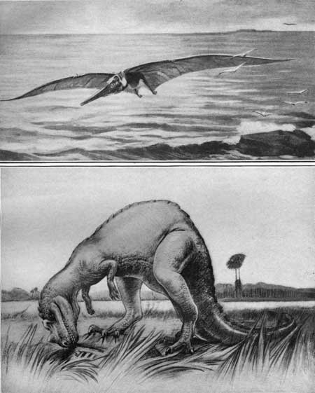
Later, in the Age of Reptiles—that is, in the early part of the Cretaceous period (see table, p. 20)—sand and mud were spread out over this region in the form of sheets ranging in total thickness from less than 100 to more than 400 feet. These hardened into the rocks which the geologists call the Morrison formation, so called because it was first studied in detail at the town of Morrison, which is situated just west of Denver, Colo. In many respects these rocks are the most interesting of those exposed in the foothills of the Rockies. They are especially fascinating because of the fossil bones of huge reptiles found in them. It is worthy of note, in this connection, that the first fossils of the greatest of all known reptilian faunas were found in these rocks at Morrison.
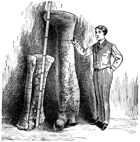
During the life of these grotesque giants the country where now the hoary summits of the mountains hang among the clouds was a low-lying swampy plain somewhat similar in character to the delta of the Mississippi. Over this plain the streams migrated, forming broad flood plains, extensive swamps, and shallow migratory lakes. In these swamps and lakes and on the surrounding plains lived the huge reptiles whose bulk seems almost incredible and whose form, as depicted by those most competent to judge their character, seems beyond the power of the imagination (see Pl. IV, B, p. 15). The largest of these creatures were plant eaters, and some of them attained a length of 85 feet or more and a weight that has been estimated as high as 20 tons. These monsters were inhabitants of the swamps (see Pl. IV, A), in which many of them perished by miring. Their bones were preserved in the mud and are now found petrified in a remarkably perfect state of preservation. The leg bone of one of these monsters, 6 feet 6 inches long, is shown in figure 3.
|
|
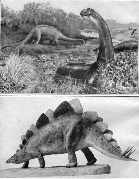
PLATE IV. A (top). BRONTOSAURUS (THUNDER LIZARD).
A great amphibious dinosaur from the horizon of the Morrison formation. Restoration by Charles R. Knight. B (bottom). STEGOSAURUS. An armored dinosaur from the horizon of the Morrison formation. ANIMALS THAT ONCE ROAMED OVER THE SITE OF THE ROCKY MOUNTAIN NATIONAL PARK. |
|
| FIG. 3—Leg bones of a dinosaur, showing size in comparison with the size of a man. |
Probably the most grotesque of all the monsters of this period was the armored dinosaur (Stegosaurus). It was a herbivorous or vegetable-eating creature, about 20 feet long and 10 feet high, with an extremely small lizard-like head, long hind legs, and short forelegs. It had a double row of enormous bony plates along its back and four huge spines near the end of its tail. For repulsive ugliness it seems to be in a class of its own. Had it not been for the strong protective armor it could scarcely have survived the attacks of its carnivorous enemies, for its brain was so ludicrously small as to suggest a mentality scarcely sufficient for conscious efforts at sell-preservation.
Scarcely less in bulk than these grotesque vegetarians and probably much more active and powerful were some of their carnivorous enemies, such as Allosaurus (Pl. V, B, p. 18), a monster 20 feet long, whose toes were armed with long, sharp claws adapted to catching and rending its prey, and whose jaws were well supplied with pointed fangs for tearing flesh.
|
|
PLATE V. A (top). RESTORATION OF A PTERODACTYL (ORNITHOSTOMA).
A flying dragon measuring 18 feet from tip to tip of wings. Winged
reptiles like this lived in central North America during the Cretaceous
period. B (bottom). ALLOSAURUS. A carnivorous dinosaur preying on one of the herbivorous dinosaurs. ANCIENT INHABITANTS OF THE ROCKY MOUNTAIN NATIONAL PARK. |
In the long ago monsters such as these lived where the Rocky Mountain National Park now is—in the long ago before the mountains were brought forth, and before erosion had succeeded in carving the upheaved mass into craggy peak and rocky gorge.
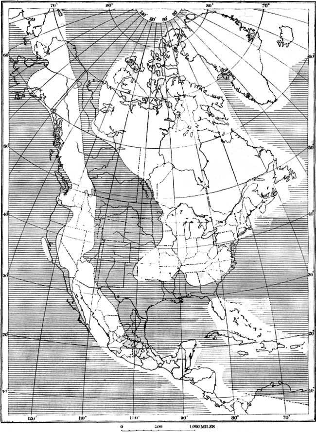
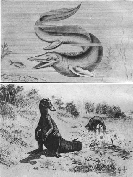
In geologic history, as in human history, change is the order of progress. The swampy subsided, and over them the sea water made its way, connecting the Gulf of Mexico with the Arctic Ocean, covering the interior of North America from Utah to the Mississippi River. (See fig. 4). In this sea sported such creatures as the great Mosasaur (Tylosaurus) (Pl. VI, A, p. 19), and over its waters sailed carnivorous flying reptiles (pterodactyls), some of which had a stretch of wing of 18 feet (see Pl. V, A, p. 18); they were animated engines of destruction, which somewhat forcibly suggest the modern war airplanes, of which they were in a sense the prototypes.
|
| FIG. 4.—Map of North America, showing distribution of land and sea in Upper Cretaceous (Benton) time. (Area not shaded indicates land; shaded area indicates sea.) (click on image for an enlargement in a new window) |
|
|
PLATE VI. A (top). RESTORATION OF TYLOSAURUS.
A marine lizard of Cretaceous age about 40 feet long—a "sea
serpent" such as swam at one time where Longs Peak now stands. Drawn by J. Green. B (bottom). THE SPOON-BILL DINOSAUR. Hadrosaurus mirabilis, a reptile of Cretaceous age. CREATURES OF LONG AGO. |
On the shores of this sea grew luxuriant vegetation which found lodgment in huge peat bogs. These deposits have been preserved for our use in the form of coal.1 On these boggy shores lived the reptiles of that age, some of which were scarcely less grotesque than their Morrison predecessors (see Pl. IV, B, p. 15). With them lived birds, some of which still retained reptilian characteristics,2 such as jaws with teeth, a character possessed by few modern birds and by these only at an embryonic stage.
1In the eastern and central parts of the United states nearly all of the coal is of Carboniferous age—an age which took its name from the carboniferous or coal-bearing character of the rocks—but in the Rocky Mountain region nearly all of the coal is younger than Carboniferous. The coal beds in western America are mainly of Cretaceous and Tertiary age. (see table, p. 20.)
2There are so many facts which indicate that birds were derived from reptiles that few paleontologists now question their ancestry. The strongest reptilian character is the jaws with teeth similar to those of the ancient reptiles. Other significant similarities are found in the skeletons. Added to these is the fact that certain modern birds during their early life have reptilian characteristics.
The first sediments laid down in this sea were the sands and pebbles formed along the shore. As the water advanced farther and farther inland, the beach sands, washed clean by wave and tide, were buried, during a later stage when the shore had advanced and the water was deeper, by the mud which gathered over them at the bottom of the sea. This sand hardened into a very resistant layer of sandstone, which has been named Dakota. It is the rock which forms the crest of the prominent hogback or ridge just east of Lyons and a few miles west of Loveland (see fig. 2, p. 16).
The sand was buried in turn by other sand, mud, and limy ooze laid down in the sea during the Cretaceous period (see table, p. 20) to a depth of several thousand feet. These beds hardened into the shale and limestone of the plain which lies east of the foothills. The petrified shells of mollusks which lived in this sea during the Cretaceous period may be seen west of Loveland in the shaly rocks at the side of the Estes Park Road.
THE BIRTH OF THE ROCKIES.
At the end of the Cretaceous period some great readjustment took place within the body of the earth which caused worldwide changes at its surface. The disturbance stirred into life the dormant roots of the ancient mountains. The sea water sank back into the ocean basins,3 and the bed of the sea was arched into a great dome (see fig. 2).
3Statements of this kind need not tax our credulity if we recall that a quantity of water equivalent to 1 per cent of the ocean would cover all the land areas of the globe to a depth of 290 feet. The water of the old Cretaceous sea would doubtless represent only a small fraction of 1 per cent of the oceanic water and when poured back into the ocean probably raised the general sea level very little.
It should not be inferred that rock movements of this kind are rapid enough to be seen or that they were accompanied by cataclysmic disturbances. Doubtless there were earthquakes occasionally, as there are now.1 But it is probable that the great rock movements which resulted in the upheaval of the Rocky Mountains were not rapid enough to be perceptible. From a geologic point of view a change in level of 1 foot in a century for any large part of the earth's surface would be a rapid change. It is probable that had a man been living during the time of even the most rapid mountain growth he would not have detected any change during his lifetime. We speak of the "everlasting hills" as types of stability and of unchanging constancy, but they are everlasting only in a relative sense, as compared with the span of human life. Every geologist knows, that the hills are constantly changing, and it is possible that these changes are going on at the present time as rapidly as they ever did.
1An earthquake shock was felt in Estes Park on Jan. 6, 1901.
Principal divisions of geologic time.2
| Era. | Period. | Epoch. | Characteristic life. | Duration, according to various estimates. |
| Millions of years. | ||||
| Cenozoic (recent life). |
Quaternary. | Recent. Pleistocene (Great Ice Age). |
"Age of man." Animals and plants of modern types. | 1 to 5. |
| Tertiary. | Pliocene. Miocene. Oligocene. Eocene. |
"Age of mammals." Possible first appearance of man. Rise and development of highest orders of plants. | ||
| Mesozoic (intermediate life). |
Cretaceous. | (3) | "Age of reptiles." Rise and culmination of huge land reptiles (dinosaurs), of shellfish with complexly partitioned coiled shells (ammonites), and of great flying reptiles. First appearance (in Jurassic) of birds and mammals; of cycads, an order of palmlike plants (in Triassic); and of angiospermous plants, among which are palms and hardwood trees (in Cretaceous). | 4 to 10. |
| Jurassic. | (3) | |||
| Triassic. | (3) | |||
| Paleozoic (old life). |
Carboniferous. | Permian. | "Age of amphibians." Dominance of club mosses (lycopods) and plants of horsetail and fern types. Primitive flowering plants and earliest conebearing trees. Beginnings of backboned land animals (land vertebrates). Insects. Animals with nautilus-like coiled shells (ammonites) and sharks abundant. | 17 to 25. |
| Pennsylvanian. | ||||
| Mississippian. | ||||
| Devonian. | (3) | "Age of fishes." shellfish (mollusks) also abundant. Rise of amphibians and land plants. | ||
| Silurian. | (4) | Shell-forming sea animals dominant, especially those related to the nautilus (cephalopods). Rise and culmination of he marine animals sometimes known as sea lilies (crinoids) and of giant scorpion-like crustaceans (euryptorids). Rise of fishes and of reef-building corals. | ||
| Ordovician. | (4) | Shell-forming sea animals, especially cephalopods and mollusk-like brachiopods, abundant. Culmination of the bugilke marine crustaceans known as trilobites. First trace of insect life. | ||
| Cambrian. | (4) | Trilobites and brachiopods most characteristic animals, seaweeds (algae) abundant. No trace of land animals found. | ||
| Proterozoic (primordial life). |
Algonkian. | 4) | First life that has left distinct record. Crustaceans, brachiopods, and seaweeds. | |
| Archean. | Crystalline rocks. | No fossils found. | 50+ | |
2The geologic record consists mainly of sedimentary beds—beds deposited in water. Over large areas long periods of uplift and erosion intervened between periods of deposition. Every such interruption in deposition in any area produces there what geologists term an unconformity. Many of the time divisions shown above are separated by such unconformities—that is, the dividing lines in the table represent local or widespread uplifts or depressions of the earth's surface.
3Epoch names omitted; in less common use than those given.
4Epoch names omitted; in less common use than those given.
HOW THE MOUNTAINS GREW.
If uplift had occurred without erosion, a great dome, somewhat like that illustrated by the broken lines of the profile (fig. 2, p. 16), but more or less warped and broken, with surface cracked and uneven, would now stand in place of the highly varied complex of peaks, ridges, and gorges which characterize the mountain region. As a matter of fact, however, the agents of erosion began their work the moment that the rising land emerged from the sea. From that time to the present the height and the character of the mountains have been dependent on the progress of the conflict between opposing forces. One group of forces strove to elevate the mountains; the other to tear them down. Sometimes one group gained the ascendancy and sometimes the other, so that the mountains have had an eventful life. Sometimes they were high and rugged, as we now see them; at other times they were worn down to a state of low relief, in which some portions of them were nearly level and others were reduced to relatively low rolling hills having smooth, gently sloping sides.
Little need be said here about the mountain-making forces. Their origin is obscure and their manner of operation is uncertain, because they originate in the unknown interior of the earth. There are several possible ways by which the Rocky Mountains may have been formed. They may represent wrinkles on the face of the earth, caused by the shrinkage of the interior; they may have been forced up by the settling of some larger portion of the earth's mass, much as the surface of soft wax is raised near an object which is thrust into it; or they may have been raised by the intrusion of molten matter forced at great depths into the underlying rocks of the mountains.
More is known of the processes by which the uplifted mass was sculptured, because these were recorded at the surface. Although erosion began as soon as the land arose above sea level, we may be permitted for the sake of clear understanding to think of the mountains as elevated before the agents of erosion began to operate; for it is difficult to carry in the mind the two concepts with all the complex interrelations. The great dome may be thought of as the block of stone from which the sculptor is to carve a group of statuary. Chief among the graver's tools to be used are rain and stream, frost and ice. The driving forces for operating these tools are chiefly gravity and the heat of the sun. The latter may be said to work both positively and negatively. Its positive work consists largely in transforming water to vapor and raising it into the air. Its negative work, or the accomplishments due to partial withdrawal of heat, results in the fall of rain and snow, frost action, and accumulation of ice in snow fields and glaciers. Gravity works chiefly through the fall of rain and the flow of streams and of glaciers.
The rocks are softened in preparation for the graver's tools by such chemical agents as carbon dioxide and other acids from decaying vegetation. The resulting statuary is the mountains. The chips formed in digging the valleys and gorges were swept away by the streams and the glaciers. Most of these have been carried out of the mountains, but the chips most recently formed are now seen as the sand of the lakes, the pebbles of the streams, and the bowlders of the great glacial moraines.
HOW THE MOUNTAINS WERE SHAPED.
Many people have the erroneous notion that some titanic force pushed mountains up in the form they now possess. On the contrary, the forms so much admired result from centuries of action by rain, stream, frost, and ice. To uncivilized people rugged mountains and deep canyons are repellent, for the untutored mind peoples them with evil spirits and imaginative dangers. But the thousands of cultured tourists who visit them find a satisfying contentment, and this satisfaction reaches its climax when appreciation of the magnificent results is accompanied by an intelligent comprehension of the processes by which these results were obtained. Some mountain climbers are content only with the thrill of mastering a difficult peak; others are more advanced in their appreciation. The massive vigor of the mountains incites enthusiasm and lifts the mind to higher levels. But surely the acme of satisfaction is reached when the thrill of attainment and the expansion of soul, so often experienced amid grand surroundings, is accompanied by an understanding of the forces which brought the objects of admiration into being.
Although this is not the place for a textbook description, in which the various agents of erosion are enumerated and evaluated, mention may be made of some of the principal ones and a brief sketch given of the manner in which they operate.
WORK OF RAIN.
Great results may be accomplished by forces so insignificant that they escape the notice of unobservant persons. Some who have not given the subject special thought may read with incredulity the statement that the great mountains of this national park were carved out largely by rain. But those who study land forms and the processes by which a landscape is shaped have long recognized the fact that rain is one of the principal factors in erosion. Careful observation during a storm will convince the most skeptical. Every raindrop that strikes the earth picks up a tiny load of mud, and the myriad drops collect as the muddy water of the rivulets which join to form the river that carries the great loads of mud to the sea.
But probably an equally important work accomplished by water falling as rain is done in connection with other chemical agents. Water has been called a universal solvent. In spite of the fact that we frequently refer to "pure water," there is no such thing as pure water on the face of the earth. It always contains other material in solution. If it contains certain kinds in sufficient quantity it may be called a mineral water, but in reality every spring, every well, and every stream contains mineral water.
The raindrop on its way from the cloud to the earth absorbs oxygen, carbon dioxide, and other gases, and, on penetrating the soil, it takes up vegetable acids and various other ingredients. It carries these with it into the minute crevices of the rock, where the acids produce chemical changes. The water is not so much the cause of the chemical action as it is the carrier of the chemical agents. Some of the newly formed compounds are easily soluble and are quickly taken into solution by the water; others are less soluble. Thus, by the chemical action of the rain water some parts of the rocks are dissolved out and the less soluble parts are left, held together so loosely that the rock crumbles.
The subject of the chemical action of water and its results might be expanded into volumes, for it embraces the production of soil, the construction of caves, the formation of minerals, and the deposition of metalliferous ores. However, the action which immediately concerns us in understanding how the rain helped to form the mountains is that of moisture on the granite of which the mountains consist. The granite contains a variety of minerals but is composed mainly of crystals of quartz and feldspar. The quartz is only slightly affected by the penetrating solutions. These solutions act principally on the feldspars, composed chiefly of sodium, potassium, calcium, aluminum, and silica. Of these elements aluminum and silica are only slightly soluble and are left as clay and sand when the rock breaks down. The sodium, potassium, and calcium unite with the carbon dioxide brought to them in solution by the water and form soluble salts, such as calcium carbonate. These are removed by the percolating waters. This removal, however, takes place irregularly along crevices or wherever the solutions can penetrate the rock. Hence the rock crumbles when the honeycombing process has gone far enough.
The decay of rocks seems more conspicuous in lowlands than in highlands, because the removal of waste products goes on less vigorously there than in highlands. Also from steep mountain surfaces a greater proportion of the rain water escapes as surface run-off. On such precipitous mountains as those of Rocky Mountain National Park chemical action is doubtless near the minimum, while the mechanical forces of disintegration, represented by stream, frost, and ice, are at their maximum.
WORK OF FROST.
Probably the most efficient of the mechanical agents of erosion, especially in the high mountains, is frost. It is well known that water expands on freezing, and it is equally well known that the expansive power of freezing water is almost irresistible. So potent is this force that it has no difficulty in splitting granite asunder and pushing great blocks of it from the cliffs. One of the dangers of climbing in the high mountains arises from falling rocks. Water fills a crack in the face of a precipice, freezes at night, and loosens a mass of rock from the face of the cliff. The ice melts during the day, and the next night the expansion of the freezing water pushes the loosened mass farther from the parent cliff. The process is repeated again and again until there finally comes a time when the mass is pushed to a position from which it falls when released by the melting ice. Many a mountain climber has hastily sought shelter from such falling rocks and counted himself fortunate when they went skirtling harmlessly to one side of him on their way down the mountain side. At altitudes where the ice melts slowly, this danger is minimized. Naturally it is increased on a warm day, when the ice holding the hanging masses melts rapidly.
The loosening of these rocks illustrates the action in the less spectacular but far more important work of frost. All rocks are porous, some more so than others. Water makes its way into the pores—into the large ones under the force of gravity and into the smaller ones under the force of capillary attraction. In some of the spaces thus filled the water is so confined that when it freezes and expands it breaks the rock asunder. When this process is repeated often enough the rock crumbles. The finer it is broken up the better opportunity have the chemical agents of operating upon it. Thus the frost and the chemical solutions cooperate in transforming the rocks to soil.
Probably every tourist in the Rocky Mountain National Park has noticed the pink angular gravel which covers the surface and makes excellent roads but which makes walking difficult where it is too deep. This material is due chiefly to the action of frost on the granite. The pink fragments are crystals of feldspar, a crystalline mineral in the granite which has the property of parting in two directions nearly at right angles to each other. For this reason when the rock breaks up under the action of frost the feldspars break into angular fragments having flat, glistening faces, which sparkle in the sunlight—the cleavage faces of the crystal.
WORK OF STREAMS.
Methods of work.—The chemical work of solutions in disintegrating the rocks and the mechanical work of frost in breaking them up would have little effect in shaping the mountains if the products of their activity were not carried away. A relatively small amount of this work is done by wind, but the disposal of rock waste falls mainly to the streams. It is their function to receive the solutions of mineral matter and the smaller fragments of rock and to transport them to the sea. If the particles are small enough they remain suspended for a time, rendering the water turbid, and may be transported for long distances down a stream before finding temporary lodgment along its course. The larger pieces of broken rock, such as bowlders pebbles, and sand, take shorter journeys. They are moved along the bed of the stream always farther and farther downstream until they are ground to powder. Also in the course of their passage they scour the rocks passed over. The streams do actual cutting by rolling pebbles along the bottom and by scouring their beds with the mud and sand held in suspension, but in ordinary cases the mechanical work of streams is subordinate to their work of transportation. In streams where muddy water passes through rock channels, such, for example, as the Colorado River in its passage through Grand Canyon, the abrasive work is at a maximum, while in streams where the water is clear its abrasive work is reduced practically to nothing. A notable example of this is seen at Niagara Falls, where the clear water passes over the rocks without so much even as keeping them free from unicellular plants which grow on their surface and form a green coating.
Ordinarily streams are inspected when the water is clear and doing little work, but the cutting is accomplished principally during times of flood when the water is muddy. Particles of mud and grains of sand are carried downstream in endless procession, each particle doing its minute part in cutting away the rock. Some, on gazing into a magnificent gorge in the rocks, are content with the enigmatical statement that it was "gnawed out by the tooth of time." Others are interested in knowing that the teeth which did the gnawing were the grains of sand set in the jaws of every flood.
Maj. Powell, who conducted the famous exploration of the Grand Canyon, had implicit faith in the ability of these minute grains to accomplish great results. Many have marveled at the temerity shown by him and his daring associates in entering a canyon with walls a mile high, from which there was no exit except at the mouth, without knowing what falls were likely to be encountered. But Powell had observed that the water of Colorado River is always muddy and his mental insight had convinced him that waterfalls are not to be expected in a muddy river. Such falls as may have existed there at one time had long ago been worn down by the myriads of sand grains which had passed over them. His faith in the efficiency of these minute agents of erosion was such that he staked his life on their accomplishment.
But even in a stream which is perpetually muddy, like the Colorado River, the abrasive work is subordinate to the work of transportation. Water descends in the form of rain so quietly that we think little of the work that it may accomplish. Parts of the rain water gather in streamlets and pick up small particles of mud and sand that lie in its way and join other streamlets similarly laden to form a brook. The water of the stronger current of the brook gathers still more of the loose material and carries it along in its passage down the river on its way to the sea. Other parts of the rain enter the rock and dissolve portions of it, as already described, and these in time find their way downstream, together with the mud. Every year the streams of the United States carry to the sea about 270,000,000 tons of dissolved mineral matter and 513,000,000 tons of suspended matter, such as silt and mud.
The rate at which streams work is influenced by many conditions, such as their rapidity of flow and the character of the country drained by them. On an average the surface of North America is lowered at the rate of 1 foot in about 9,000 years. It has been estimated that if this erosive action of the streams of the United States could have been concentrated on the Isthmus of Panama it would have dug in about 73 days the canal which has just been completed after 10 years' work with the most powerful appliances yet devised by man.
Streams of park exceptional.—Every visitor to the Rocky Mountain National Park has observed that the streams are remarkably clear. They carry little mud, for although the force of the descending water is great its grinding action on the rocks is slight because of the want of particles held in suspension. These energetic streams are accomplishing relatively little at present toward the shaping of the mountains. They constitute an exception to the general rule, and there is a special reason for this exception. The rocks along the streams are only slightly disintegrated. Most of them have a fresh, hard surface. The reason for this lies in the recent glaciation which is described in the following section under work of ice. The ice removed the soft weathered parts, and the time that has elapsed since the glaciers disappeared has not been long enough for the rocks to decay to such an extent that they furnish large quantities of mud and sand. However, it has not always been thus, nor will it always remain thus. In time the fresh faces of the glaciated rocks will weather and the normal conditions of an unglaciated region will be reestablished.
Stripping of the mountains.—Through the long ages during which the mountains have been struggling to rise vast quantities of rock waste have been carried from them by the streams. In the dim past, after the close of the Cretaceous period, as soon as they had lifted their heads from the sea, they were attacked by rain, streams, and chemical solutions, so that even though the vertical movement totaled many thousands of feet the mountains may not have been greater at any time in the past than they are now.
The first work of erosion was the removal of the relatively soft sedimentary rocks which at first extended over the site of the growing mountains. These rocks were thousands of feet thick, and their removal was no small task. Also the task was made difficult and time of its accomplishment lengthened by floods of molten rock poured out on the surface. These were removed, together with the sedimentary rocks. During this early period of erosion not only were the thousands of feet of sedimentary rock and the sheets of hardened lava removed, but the underlying crystalline rocks were themselves deeply eroded. Some time early in the Tertiary period (see table of geologic time, p. 20) the forces of erosion seem to have prevailed over the mountain-making forces, and the young mountains were reduced to a rolling plain, known technically as a peneplain, or an "almost plain," and to relatively low hills with gently inclined slopes and broad, shallow valleys. The highest hills of that day may have stood 2,000 feet or even more above the general level of the peneplain. Few definite statements can be made concerning this old plain until it is studied in detail.
An old plain of erosion.—Later, when the mountains were raised still farther, the peneplain was lifted and the rising mass of rock was again deeply carved into mountains and valleys, but the raised surface has not been entirely destroyed. So many remnants of it remain that from a distance the tops of the mountains have the appearance of forming an even-crested ridge (see Pl. VII). Remnants of it remain on Flattop Mountain (Pl. IX, p. 34) and in many other places near the top of the range. It shows conspicuously near the head of Forest Canyon (Pl. XXII, B, p. 54) and above Hallett Glacier (Pl. XVI, B, p.49). But the largest and most plainly recognizable remnant stretches out several miles on either side of Flattop Mountain. This ancient plain will be referred to so often in the descriptions which follow that a name for it seems desirable, and I propose to call it the Flattop Peneplain. A characteristic view of it is given in Plate IX (p. 34). If this high-altitude plain were now restored from such remnants as remain, it would seem as if the surface was very uneven. Mountains of considerable height rise steeply from the general level (see Hallett Peak, Pl. IX, p. 34), but it is not now known how many of the irregularities of the surface are due to incomplete erosion when the old plain was formed and how many of them are due to faulting and to warping of the surface during the process of elevation.
|
|
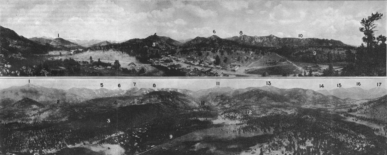
PLATE VII. A (top). VIEW FROM PROSPECT
MOUNTAIN WESTWARD OVER ESTES PARK. Showing the near-by mountains rising
to a level which is essentially the same as that of the so-called Rocky
Mountain peneplain of areas further south. 1, Gianttrack Mountain; 2,
Thompson Canyon; 3, Oldman Mountain; 4, Deer Mountain; 5, Fall River; 6,
Castle Mountain; 7, Black Canyon; 8, The Needles; 9, Stanley Hotel; 10.
Twin Owls. B (bottom). VIEW FROM THE HILL AT MORAINE PARK, WHICH APPEARS IN THE VIEW ABOVE, BETWEEN GIANTTRACK MOUNTAIN AND DEER MOUNTAIN. Showing the melting basin of Thompson Glacier (Moraine Park) with its lateral moraines in the foreground and the high range beyond, at whose relatively even crest are numerous remnants of an old plain here called the Flattop peneplain. 1, Longs Peak; 2, Bartholf Peak; 3, South Moraine of Thompson Glacier; 4, Moraine of Bartholf Glacier; 5, Taylor Peak; 6, Otis Peak; 7, Hallett Peak; 8, Flattop Mountain; 9, Moraine Peak; 10, Gorge of Thompson Glacier; 11, Stones Peak; 12, North Moraine of Thompson Glacier; 13, Trail Ridge; 14, Mount Chapin; 15, Mount Chiquita; 16, Ypsilon Mountain; 17, Mount Fairchild; 18, Highline Drive. Photographs by Frank W. Byerly. PANORAMAS OF ESTES PARK AND OF THE HIGH MOUNTAINS TO THE WEST. (click on image for an enlargement in a new window) |
|
| PLATE IX. THE FLATTOP PENEPLAIN. View of a part of Flattop Mountain, showing Hallett Peak in the middle ground and the square head of Longs Peak in the distance to the left. The gently rolling surface covering several square miles at altitudes near 1,200 feet is a remnant of a surface of erosion which once extended continuously over the site of the Rocky Mountain National Park when the mountains were much lower than they are now. During the elevation of these mountains this surface was raised and in most places was destroyed by later erosion. It suffered especially from the glaciers, which gnawed great holes in the sides of the mountains, but it is still recognizable in many places. Photograph by Frank W. Byerly. |
About the time that this ancient plain was forming the volcanic forces again were busy, and floods of molten rocks similar to those previously mentioned were poured out on the surface. These hardened on cooling into resistant rocks, and nearly all were eroded away; but one large mass remains in Specimen Mountain, which consists of beds made up of lava flows, fragmental igneous rock, and bowlders of the older mountain rock.
Many periods of uplift.—There were several stages of mountain uplift, alternating with long periods of relative cessation of movement, during which the erosional forces gained ascendancy over the elevating forces. During one of the long periods of erosion the mountain region was reduced in many places to a nearly plane surface. This surface has been studied in the regions south of the Rocky Mountain National Park, where it has been called the Rocky Mountain Peneplain. The mountains of Estes Park rise to a general level (see Pl. VII), which may be a part of this peneplain. Still later streams cut deeply into this plain, forming the present broad valleys, such as Estes Park, and shaping the mountains into something like their present form.
Thus the mountains were shaped and the valleys dug mainly by water. The final shaping of the high peaks and the excavating of the gorges in the sides of them were done by ice. The glacial cirques, the rock-walled gorges, the pinnacled summits, the crested ridges, and many of the other greatly admired features of the landscape are the result of the intensive action of the ice during a relatively short period. The work of the glaciers in shaping the mountains was accomplished in relatively recent time, hence the results are conspicuous for the same reason that objects close to us intrude themselves upon our attention. But in reality these sink into insignificance when compared to the stupendous results accomplished by water in shaping the landscape.
WORK OF ICE.
WHEN AND WHY GLACIERS FORM.
The most spectacular features of the landscape in the Rocky Mountain National Park are due to ice. This is because the glaciation of this region was the last important event in its geologic history. The Great Ice Age dates back beyond the origin of human history, but in terms of geologic time it was very recent. The glaciation of the mountains was the last geologic event of the region, and the glacial epoch has in reality not yet closed for, the higher parts of the park, where small glaciers still exist.
The popular notion that glaciers and fields of perpetual snow are due to excessively low temperature is not wholly correct. However, in order that the masses of snow and ice may endure, the average yearly temperature of the region must be low enough that the snow fall of winter does not all melt in summer. The one condition necessary for a snow field is an excess of accumulation over waste. Those of the mountains are due chiefly to drifting. In a region where there is heavy snowfall during the winter the snow fields endure throughout the summer at much lower altitudes than where the snowfall is light, for the obvious reason that the heat of summer, although it may be intense, can not melt all of the snow. On Mount Rainier, in the State of Washington, where the annual snowfall exceeds 20 feet, the glacial ice extends down within 3,960 feet of sea level, but in the Rocky Mountain National Park, where the annual snowfall is less than 10 feet, the glaciers extend little lower than 12,000 feet above sea level.
LIVING GLACIERS.
When the annual accumulation of snow is greater for any reason than the annual melting, snow fields are formed. The surface snow soon changes from the flaky form to a granular form, and these granules consolidate into ice. When this granular ice accumulates to a sufficient depth it begins to move and becomes a glacier. The difference between a glacier and other masses of ice seems to depend on motion. Profs. Chamberlin and Salisbury1 state that—
Brittle and resistant as ice seems, it exhibits under proper conditions some of the outward characteristics of a plastic substance. Thus it may be made to change its form and may even be molded into almost any desired shape, if carefully subjected to sufficient pressure steadily applied through long intervals of time. These changes may be brought about without visible fracture and have been thought to point to a viscous condition of the ice. There is much reason, however, * * * to question this interpretation of the ultimate nature of the movement. Whatever this may be, the mass result of the movement in a field of ice is comparable, in a superficial way at least, to that which would be brought about if the ice were capable of moving like a viscous liquid, the motion taking place with extreme slowness. This motion of the ice in an ice field is glacier motion and ice thus moving is glacier ice.
1Chamberlin, T. C.. and Salisbury, R. D., Geology, vol. 1, pp. 236, 237, 1904.
When the moving ice is confined to a valley or gorge it is known as a valley glacier. These are often called alpine glaciers, because they were first studied in detail in the Alps. Probably the nearest approach to a typical valley or alpine glacier in the Rocky Mountain National Park is found in Andrews Glacier. (Pl. XXXI, p. 68.) In some places the snow accumulates in a sheltered nook on a cliff and forms a small and often steeply inclined mass of ice called a cliff glacier. (Pl. XXIX, p. 67.) Such a mass of ice seems to be insecure and is sometimes called a hanging glacier.
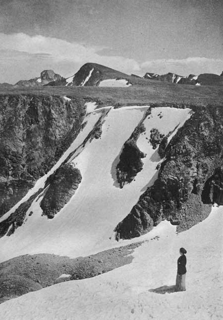
Although movement is the essential character of a glacier, there seems to be no limiting rate of movement. Hence, as a mass of ice once large and active gradually diminishes, it is difficult, if not impossible, to determine when it ceases to be a glacier. The question is especially pertinent in the Rocky Mountain National Park, where several bodies of ice are now at the critical stage between glacier and snow field. A few of these bodies have perceptible movement and are genuine glaciers. Others move intermittently and are therefore glaciers at certain times and not glaciers at other times,1 but the greater number are not known to have measurable motion—at least their rate of motion, if they have any, has not been determined and is so slight that it is not made apparent by any recognized external signs. The bodies of ice in this park now recognized as true glaciers are Hallett Glacier, Sprague Glacier, Tyndall Glacier, Andrews Glacier, and Taylor Glacier. A mile south of the park are two splendid masses known as the St. Vrain Glaciers, and about 10 miles farther south lies Arapahoe Glacier, the finest body of glacial ice in the southern Rocky Mountains.
1In a letter to the writer dated July 25, 1916, Enos A. Mills states: "I have made three measurements on the small ice field that lies on the eastern wall of Longs Peak above chasm Lake. In 1909 I made a 60-day test. The movement made was about 0.07 inch per day. In 1908 a 30-day test showed a movement of about 0.04 inch per day. A 10-day test in 1907 showed no perceptible movement.
"This ice field was measured also by Chapin in 1888, I think, and he reported no perceptible movement.
"A 15-day test on Sprague Glacier in 1906 showed a movement of 0.08 Inch per day. In 1890 Hallett Glacier showed a movement of 1.01 inches per day, and in 1907 its movement was 0.06 inch per day. All these measurements were made in the autumn."
It was Hallett Glacier that gave rise several years ago to a controversy as to what constitutes a glacier. The definite question arose, "Is Hallett Glacier a glacier?" In 1884 Mr. W. L. Hallett, of Colorado Springs, for whom this body of ice was named, discovered a crevasse in it. Crevasses are common in glaciers and indicate motion of the ice. Hallett's discovery was used as proof2 that a true glacier had been discovered in Colorado. This raised the question of the likenesses and differences between snow fields and glaciers. The question was discussed by S. F. Emmons,3 a well-known geologist, who pointed out that the present masses of ice in the Rocky Mountains are mere shadows of the former glaciers and argued that Hallett Glacier and similar masses of ice are not true glaciers. Nevertheless it has continued to be called a glacier, and, according to the definition previously given, several of the less well-known bodies of ice naturally fall with it into the class of true glaciers.
2Stone, G. H., A live glacier on Hagues Peak, Colo.: Science, vol. 10, pp. 153, 114, 1887.
3Emmons, S. F., On glaciers in the Rocky Mountains: Colorado Sci. Soc., Proc. vol. 2, pp. 211, 227, 1888.
ANCIENT GLACIERS.
Whether or not the above conclusion is accepted as final there is no doubt of the existence of active glaciers in this territory in times past. Evidences of these are found in many places. Conspicuous among them are the lateral, terminal, and ground moraines, the smoothly rounded rock surfaces, polished and striated bowlders, steep-walled gorges, U-shaped valleys, and pocket lakes.
In the moraines are bowlders, cobbles, pebbles, sand, and clay intermingled. This physical heterogeneity is one of the most distinctive characteristics of morainal material and therefore one of the best evidences of the former existence of glaciers. All the distinctive marks of the ancient glaciers are found in great perfection, so that the park has been called a primer of glacial geology. The details of the several glaciated areas are enumerated in the descriptions that follow under the heading "The park as seen from the trails" (p. 45).
There appear to be two stages of glaciation represented in this park—an older one of which little is now known and a younger one called the Wisconsin stage, because it seems to correspond in time with the last stage of continental glaciation, which is typically developed in Wisconsin and was named for that State. Little need be said at this time of the older stage, for the proofs of its existence are not entirely conclusive. Apparently such broad open valleys as Estes Park and Tahosa Valley were shaped by glacial ice. They have the broad floors, the precipitous walls (Pl. XV, A, p. 48), and the perched lakes which characterize glacial valleys, but they lie outside of the area affected by the glaciers of the Wisconsin stage.
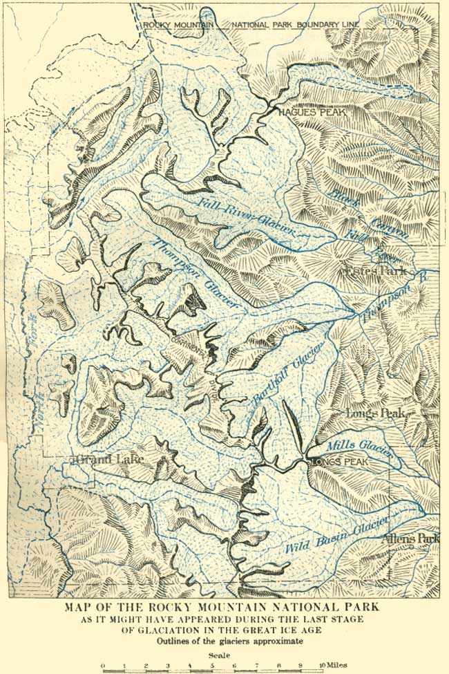
During the younger or Wisconsin stage of glaciation the ice accumulated in the valleys previously formed by the streams—and perhaps shaped to some extent by the older glaciers—and pushed its way from the high mountains down these valleys to altitudes of about 8,000 feet. The areas occupied by the ice are plainly marked and could be mapped accurately with little difficulty. But this mapping would require a large amount of detailed work and has not yet been done. The accompanying illustration (Pl. VIII) outlines the glaciated areas with sufficient accuracy for present purposes. The five named glaciers are outlined more accurately than those in the western and northern parts of the park. The areas occupied by the latter are not easily traversed at present for want of good trails. It is beyond question, however, that the high-altitude valleys and gorges were all occupied by glacial ice, although the outlines as shown in the figure are only approximate.
|
| PLATE VIII. MAP OF THE ROCKY MOUNTAIN NATIONAL PARK as it might have appeared during the last stage of glaciation in the great ice age. Outlines of the glaciers approximate. |
Fall River Glacier.—The body of ice which occupied the upper part of the Fall River drainage area had a maximum length of nearly 10 miles and a width of more than 7 miles. Its principal lobe originated in the high mountains to the west and filled the main valley. Its principal tributary originated on Hagues Peak and filled the valleys between this peak and Mount Chapin. The Fall River lobe seems to have been much more powerful than the other lobes of ice and so modified its course that the valley of Roaring River was left "hanging" about 500 feet above Fall River. The ice of the united lobes was pushed through Horseshoe Park, where it built lateral moraines along its northern and southern margins about 900 feet above the present floor of the valley. Each of these conspicuous ridges of loose bowlders is separated from the solid mountain rock on either side of the park by a narrow trough.
Horseshoe Park is the melting basin of Fall River Glacier. Here the supply of ice which moved down the steep gorges just equaled the waste due to melting. For this reason all the fragments of rock borne by the glacier were dropped here as the ice melted from under them. The fragments which fell from the sides piled up in lateral moraines. Some of those in the central parts of the glacier were carried downstream to the end of the ice and deposited as the terminal moraine. Others lodged at the bottom of the glacier to form the ground moraine and were overridden by the ice, thus forming the relatively level floor of Horseshoe Park.
Before the Great Ice Age Horseshoe Park was doubtless a part of an ordinary V-shaped valley like that between Deer Mountain and McGregor Mountain east of the terminal moraine, but the narrow lower part of the "V" was filled with fragmental rock. This narrow part of the valley east of Horseshoe Park would appear now as wide as that park if it were filled to the same extent. The quantity of morainal material in the floor and walls of Horseshoe Park indicates that the ice occupied it for a long time. Also the smoothness of the floor and the absence of large piles of bowlders indicate that the retreat of the glacier was relatively rapid when the ice finally melted.
Thompson Glacier.—Two large glaciers formed on the headwaters of Thompson River. The largest one, heading in Forest Canyon and its tributary gorges, was about 15 miles long. It had several tributary lobes from the Continental Divide, among them one in Hayden Canyon, one in Spruce Canyon, at the head of which now lies Sprague Glacier (Pl. XXV, p. 60), and one in Odessa Gorge. The ice from the united lobes crept down the valley of the Thompson, overriding such minor ridges as that north of Cub Lake, and halted in Moraine Park. This park is similar in nature and origin to Horseshoe Park and is the melting basin of Thompson Glacier.
To judge from results, Thompson Glacier was a vigorous one. Forest Canyon and the tributary gorges just mentioned contain numerous and forceful reminders of its power. Many cirques and deep gorges were scooped out of the solid rock by it, and rounded bowlders were carried down to Moraine Park, where the valley floor was built up by ground moraine and the lateral moraines raised to a height of nearly 1,000 feet. It would be difficult to find a better or more conspicuous example of a lateral moraine than the even-crested ridge south of Moraine Park.
Bartholf Glacier.—The glacier which descended though Bartholf Park was a relatively short one, never exceeding 8 miles in length. However, it originated on the highest mountain in the park and its gradient, or average slope of bed, was steep, hence its gouging action was vigorous. The principal lobe of ice occupied Glacier Gorge. Another scarcely less vigorous lobe occupied Loch Vale and headed in the cirques now occupied by Taylor Glacier and Andrews Glacier. Less extensive but scarcely less vigorous lobes occupied the gorges south of Flattop Mountain, in one of which Tyndall Glacier reposes.
These lobes of moving ice joined in a grand melee in Bartholf Park. The relatively small tongue of ice from the Flattop region tended to move eastward but was crowded toward the north by the more powerful mass from Glacier Gorge and Loch Vale. Hence most of the ice-borne material was carried north of the park and piled up in the great moraine, on the top of which is Bierstadt Lake. This moraine occupies most of the space between Milk Creek and Glacier Creek and is more than a mile wide. Its thickness is not definitely known, but it rises 900 feet or more above the floor of Bartholf Park, and this floor is itself built up to some unknown extent by ground moraine.
Mills Glacier.—Mills Glacier seems like a small one when compared with others (see Pl. VIII). It was not more than 4 miles long and a mile wide, but the area occupied by it is one of the most accessible and easily observed of those occupied by the ancient glaciers in the park. The entire site of this glacier can be seen from a single position. From Twin Sisters, east of Longs Peak, The Chasm, or cirque in which this glacier originated, and the glacial trough and moraines are spread out before the observer as on a map (Pl. XXXV, A, p. 71).
For some reason not now known, this glacier differed from the others described in not building at its lower end a melting basin or moraine-inclosed park. In the other four the parklike melting basins lie between the most conspicuous portions of the lateral moraines. In the case of Mills Glacier the most prominent portions of the laterals inclose only a narrow trough. There is some doubt as to the relation of the moraines of Mills Glacier to those of the possibly older glacier which is supposed to have filled Tahosa Valley. In this valley are basins now filled with boggy material and accumulations of glacial débris, which might be either old till or outwash material from Mills Glacier. Also outside of the conspicuous ridge called Mills Moraine is at least one less prominent morainal ridge, which denotes that this glacier covered a somewhat larger area during the early part of its existence than it did later. As the bowlders of this outer ridge are not notably more weathered than those of the higher inner ridge, the outer moraine seems to belong to the Wisconsin stage of glaciation rather than to the earlier stage.
Wild Basin Glacier.—The body of ice which formed at the head of the St. Vrain drainage area was the most symmetrical of the five named glaciers of the Wisconsin stage of glaciation. It filled Wild Basin to a width of about 6 miles, heading in the numerous gorges of the high range from Longs Peak to Ogalalla Peak. It extended nearly 9 miles down the valley of the North St. Vrain, forming a long melting basin between Copeland Moraine on the north and an equally prominent lateral on the south (Pl. XLIII, B, p. 81). Copeland Lake lies within this basin, on a shelf of morainal material a few feet above the general level of the valley floor, and the stage road between Ward and Estes Park crosses the basin near the eastern end. The terminal moraine lies east of the road near the junction of Horse Creek and the St. Vrain.
Glaciers of North Fork and its tributaries.—Little is known of the geology west of the Continental Divide. The evidences of former glaciers were seen in many places and the general outlines of the ancient ice are indicated by the topography, but the boundaries shown in Plate VIII (p. 30), are only approximate. The essential facts relating to the old glaciers of this region have long been known from the description of Archibald R. Marvine in the report of the United States Geological and Geographical Survey of the Territories for the year 1873, from which the following account is chiefly adapted:
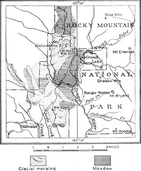
The floor of Grand Valley consists of terminal and ground moraine as far south as the southern extremity of the Rocky Mountain National Park. Throughout most of its length the floor consists of ground moraine or material left at the bottom of the glacier and leveled off by the ice riding over it. Thus was formed the "Meadows" or flat floor over which the river now winds, in serpentine course, among the swamps, grassy meadows, and dense thickets of brush. From the southern extremity of the moraine northward for several miles the meadows are interrupted by ridges and irregularly shaped hills made up of rock débris deposited by the ancient glaciers. They are roughly semicircular in form and north of Grand Lake cross the valley somewhat regularly. These constitute the terminal moraines of the glacier which occupied the valley of the North Fork of Grand River. In its halting retreat the glacier built a succession of terminal moraines, reaching altitudes of 300 or 400 feet above the level of the meadows. Each semicircular ridge across the valley represents a halt at the front of the retreating glacier. Their surface is uneven, there being in some places abrupt depressions down to 60 feet in depth, having no outlet. Some of these are occupied by undrained lakes. West of Grand Lake is a semicircular ridge situated between the North Fork and the drainage from the lake. This is a medial moraine formed where the glacier of North Fork Valley joined the glacier from the gorges which converge in Grand Lake. The latter seems to have extended down the Great Valley several miles, but it is not possible, without more detailed field study, to say whether the southernmost ridges are moraines of the North Fork Glacier or the Grand Lake glaciers, or a combination of both. There are, however, three fairly well defined ridges which seem to represent stages in the retreat of the glacier that passed through Grand Lake. The western end of the lake is inclosed by a low morainal ridge. It is narrow and steep sided, ranging in height from a few feet to 100 feet or more, and offers choice sites for summer cottages. It represents a relatively short halt in the retreat of the glacier.
The next older terminal moraine crosses the valley about 2 miles south of the outlet of the lake. The North Fork, which flows west of the medial moraine previously described, turns sharply to the north, cutting through the low but well-defined ridge of this moraine, and flows in an easterly direction north of the ridge for more than a mile to its junction with the Grand Lake drainage, where the combined stream breaks again through the moraine. Between this gap and the lake the ridge is a lateral moraine, attaining an altitude of 800 feet or more above the level of the lake.
A still older and also more prominent terminal moraine lies nearly a mile farther south, the two separated from each other by a meadow. The river breaks through this ridge and enters a narrow canyon cut in the granitic rock. The river which had obviously occupied the main valley previous to the Great Ice Age apparently was crowded out of its former course by the accumulation of ice-borne material. When the glacier ice melted the river found the lowest course at the side of the moraine and, in place of reexcavating its old valley, cut a new one through the solid rock.
Good exposures of the rocks in the moraines are not numerous. These rocks consist of schist and granite, which decompose readily on exposure. The morainal masses are covered with scanty soil, and on them is a thick growth of pines. In many places the lodgepole pines grow so close together that passage across the moraines is almost impossible. Traversing these thickets is particularly annoying when they have been partly destroyed by wind or fire, the fallen trees making the thickets almost impenetrable.
|
| FIG. 5.—Sketch map showing the glacial moraines in the valley of North Fork of Grand River near Grand Lake, Colo. |
Glaciers in the northern part of the park.—It is known that the valleys in the northern part of the Rocky Mountain National Park, such as those of the Cache la Poudre and its tributaries, are glaciated, but I have seen them only from a distance, and the outlines of the glacial ice shown in Plate VIII (p. 30) have been drawn chiefly from topographic evidence. The boundaries may be materially changed when these areas are examined in detail.
HOW THE GLACIERS WORKED.
The kind of work performed by the ice in shaping the mountains was much the same in each of the glaciers, and if we can see in imagination how a bowlder was formed, what work it did, and how it was carried to its present resting place, we will come close to an understanding of glacial erosion. As we stand at the head of one of the gorges and gaze down its rock-walled trough we may easily picture the great river of ice that formerly cascaded over its cliffs, gnawing at the sides of the mountains, plucking out their rock ribs, grinding and polishing the rocks, and sweeping away the débris.
Along the cliffs above the ice, and as far below its surface as water will freeze and thaw, fragments of rock large and small are loosened. Those from the overhanging cliffs fall on the ice and are carried on it down the valley. Those from below the surface of the ice are plucked from the walls and held within the ice, where they serve as the cutting tools which wear down the floor of the gorge. A thickness of 2,000 feet is a conservative estimate for the ice which filled many of the cirques and gorges of this park. A mass of ice of this thickness exerts a pressure of 56 tons on each square foot of its bed. The deeper the ice the stronger is its hold on the rocks and the greater is its ability to tear fragments of it from the walls and from the floor. The fragments of rock near the bottom and sides of the moving mass are held as in the grip of a vise. This rock-shod ice under pressure from above acts like a giant rasp, plucking away loosened fragments, scouring, grinding, and polishing the rocks over which it moves.
Such masses of ice do not adjust themselves readily to the irregularities of the valleys which they occupy. In consequence of this, more than ordinary force is exerted on the projecting mountain spurs and opposing ledges and these are worn away relatively fast. Hence a glacial trough has fewer irregularities than a stream-worn valley. Also, since the work of the ice increases with pressure, the bottom of the trough undergoes great modification. A glacial gorge has a characteristic U-shaped profile and is distinguishable by this feature from a stream-cut valley, which is characterized by a V-shaped profile (see fig. 6).
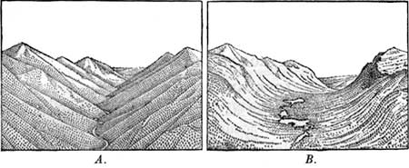
|
| FIG. 6.—A, Sketch of stream-cut valley; B, Sketch of came valley after modification by glaciation. |
In an alpine glacier the ice always moves down the valley. It never retreats. If the ice at the lower end melts faster than it is renewed from above the glacier may retreat, but the ice of the glacier moves always forward. Hence we may properly speak of a retreating glacier, but not of retreating ice. For this reason whether the glacier is advancing or retreating it is always bearing a load of rock débris forward. That borne to the end of the ice is dropped as the ice melts from under it and forms the terminal moraine; some lodges at the bottom behind the terminal, allowing the ice to ride over it, and is called ground moraine; and some accumulates at the sides as lateral moraine.
| <<< Previous | <<< Contents >>> | Next >>> |
sec1.htm
Last Updated: 11-Dec-2006