|
| ||||||||||
| Intro | Author | Subject | Volume | Volume/Title | NPS | |||||
|
Volume 2 - No. 3 |
July, 1940 |
|
CANYON WONDERLANDS By Norman D. Nevills.
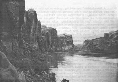
It has been my good fortune to cover rather thoroughly the proposed Escalante National Recreational Area in Utah. This area, in one of the most roadless sections in the United States, is a part of the Colorado River Basin, which includes Grand Canyon NationalPark, Boulder Dam National Recreational Area, and Dinosaur National Monument. The 2,000 square miles are directly associated with the Colorado, Green, and San Juan Rivers. Commencing on the Green River, at influent San Raphael River, a rough parallel to the Green extends to the confluence with the Colorado River. The line on each side is approximately 6 miles from the Green River at all points. From Moab, Utah, bridge crossing of the Colorado River, commences another parallel similar in bounds to that on the Green, extending also to thee Green-Colorado junction, 68 miles below. From the junction, the line extends from 6 to 10 miles on each side of the combined rivers, and on the east, goes south to a point on the San Juan River at the Clay Hills. The boundary then follows the north bank of the San Juan River to its junction with the Colorado River in Glen Canyon. The west line, south from the Green-Colorado junction, extends back 6 to 10 miles, and goes as far down as the point below influent San Juan, known as the "Crossing of the Fathers." Here, in 1776, Father Silevestre Velez de Escalante, guided by Indians, made the first crossing of the Colorado River by white men. From this early Spanish padre-explorer comes the name suggested as the most fitting for this proposed national recreational area. My explorations by boat through the canyons and gorges of the Colorado, Green and San Juan Rivers, lead me to believe that there is no section adjacent to any of these streams that offers such a tremendous field of scenic and general interest. Look down, up, or straight ahead - there is a combination of all possible types of views and formations. The road problem has received considerable study, and preliminary surveys indicate construction is feasible. The great mesas that reach out to all strategic points are well adapted to road building. Navigation of the streams is safe and practical. Between the junction of the Colorado and Green Rivers, and Glen Canyon, lies 54-mile-long Cataract Canyon. This is the only stretch that requires a specialized type of organized boating, equipped to handle rapids and rough water. On all the other sections many types of craft are practical, and right now are actually in use.
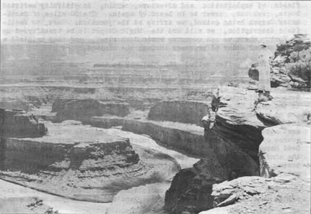
Few places in the world have the high, sheer, orange-colored walls found in these canyons. Their complicated twists and windings make for constant wonder in their ever-changing tapestries, formations and colorings. Mountains, desert, formidable canyons; natural bridges and arches of stone; prehistoric paintings and dwellings; glorious canyon-desert flora; mountain sheep and innumerable deer; vast panoramic displays and intriguing historic interests -- there is a bewildering array of attractions. Dead Horse Point is accessible by road from Moab, Utah. This promontory on a great mesa, towering over the Green and Colorado Rivers from a height of 3,000 feet, gives an unequalled view of the canyon country. Here, in one encompassing panorama we can see the great gorges of the two rivers for 70 miles. From the La Sal Mountains on the east, to the Henry Mountains on the west, lie these canyons, the adjoining country broken up and criss-crossed by other canyons where sandstones and shales have been eroded into spires, caves, and other formations. Exploration has revealed that the whole of the proposed Escalante area is made up of this and similar types of formation. The canyons of the three rivers are subdivided into groups of canyons. These subdivisions are marked by geographical changes that range from 10 miles to several hundred miles in length. Thus, leaving the influent San Raphael River, on the lower Green River in Gray Canyon, we immediately enter Labyrinth Canyon, marked by its 50 odd miles of windings and turns between sheer sandstone walls. The bends approximately double the distance the river has to travel in its southerly course. The general effect, with the orange-colored walls, interspersed with layers of variegated shale, is beautiful and interesting. There are many deer to be seen, and all along are evidences of the ancient cliff dwellers and their work. In this section of Labyrinth Canyon lies famed Bow Knot Bend, where the river, over a circular course, doubles back to within a few hundred feet of itself. This thin wall dividing the stream has been cut to form a saddle which a few minutes climbing easily conquers. Here an exceptionally fine view of the river and canyon is afforded, and it is most interesting to see the boats finally heave in sight after taking 7 miles to gain a point that took us but a few minutes of climbing.
A few minutes' scrambling gets us to the boats, and before long we are reaching the next canyon of this series. The river here, as we will find below, is unbroken by any riffles. Clear fresh water can be replenished at many of the lateral canyons we pass. A breaking down of the formation on both sides, with an immediate resumption of an even narrower walled canyon within a half mile, marks the entry into the next sub-canyon, Stillwater. Now the walls have grown closer. Their height, 500 to 700 feet, remains the same, but the complete sheerness gives an illusion of even greater height. The river, now constricted to a 200 to 250-foot channel, is a silent, smooth, apparantly unmoving body of water. The effect of no motion is swiftly dispelled upon observing the banks of the stream. The river slides by effortlessly as the 6-mile current hurries on to join the Colorado River below. Deer are to be seen in this canyon, on the willow-fringed bars adjoining side canyons. As we go further south the difference in vegetation is noticeable. These sheltered canyons are abundant in desert flora whose unique setting present a beautiful and remarkable sight. From close by the water's edge, to a precarious perch on a small projecting ledge high above, the canyon discloses a wealth of plant life. Names of past voyagers through these canyons are occasionally seen inscribed on the walls, and it calls to mind the experiences of these early travelers who endured such hardships to "run the Colorado." Before the perfection of the present type of cataract boats, canyons such as the Cataract below, offered dangerous and more often impassable obstructions to boats and men. Prospectors and trappers, both in search of new fields of exploitation and adventure, would, in pitifully unfitted boats, set out, never to be heard of again. The 50 miles of Stillwater Canyon being gained, we arrive at the junction. Here, to facilitate description, we will use the Magic Carpet to be transferred up to Moab, where we can commence again down river, and thus maintain a more logical order of progress through the canyons. At Moab, often called the "Gateway to the Grand Canyon", the river is spanned by a bridge. The town lies in a valley through which the Colorado flows, entering into the canyon literally at the edge of town. From the high orange-colored sandstone walls comes the name Orange Cliff Canyon, the first major sub-canyon in the series leading to the Grand Canyon proper. Our course is devious, though the bends are on a larger scale than on the Green. Here we find ancient ruins and pictographs. The flats and bars are grazing spots for deer. Several natural bridges are easily reached from the main canyon. In the course of our next 68 miles to the junction we reach many places where Dead Horse Point can be seen 3,000 feet above. All too soon we reach the confluence of the two rivers, and here, changing to cataract-type boats, we set forth on an entirely different type of navigation and water. For the next 54 miles the combined force of the two rivers is expended in a mad dash down steeply inclined Cataract Canyon, with great roaring cataracts and rapids every mile or so. Only well equipped parties with good leadership can make the descent. Eight days are generally used in going through. The compensations for the efforts expended are tremendous. Here limestone formations predominate, and their jagged, bold escarpments, combined with the sandstones and shales, make a deep setting for this big river. Mountain sheep are now found, and, startled, they bound up the series of ledges with amazing speed and grace. Nowhere in the whole series of canyons, lest it be the San Juan, are the walls so towering, rugged, and splashed with color. Some of the lateral canyons of Cataract are densely filled with cliff dwellings, their very remoteness having kept them inviolate all these years. At Mille Crag Bend, so named by Major J. W. Powell in 1869, because of its outstanding number of crags and spires, the foot of Cataract Canyon is terraced from the water's edge to the top of the cliffs. Comes now a 10-mile stretch of closely walled sandstone canyon called Narrow Canyon. The water has lost its desire to be wild, and again we float on a smooth-flowing stream. The terminus of Narrow Canyon is at influent Dirty Devil, or Fremont River, also the head of 175-mile long Glen Canyon, whose stretch of smooth water extends to Lees Ferry, at the head of Marble Canyon. For the next 140 miles, to the Crossing of the Fathers, and the southern boundary line for the proposed Escalante National Recreational Area, the Navajo sandstone is predominant. There are arches, dells, glens, natural bridges, towering spires, and brilliant redbud trees. The water is smooth, and we are often stopping to explore some of the mystic-looking side canyons that extend back considerable distances with high walls that can be spanned by extending one's arms. Hidden Passage Canyon and Music Temple are but two of the side canyons that never fail to thrill a visitor. At Hole-in-the-Rock we see the river crossing of the Old Mormon Trail from Escalante to Bluff. Throughout the length of Glen Canyon there are innumerable prehistoric ruins and pictographs. Occasionally the canyon enlarges to permit views of the Blue, Henry, and Navajo Mountains. After the San Juan River is passed, a striking picture of Navajo Mountain warns us of approach to Forbidden Canyon, easy trail to the Rainbow Bridge. From here, an hour's walk along a clear stream brings us to Nonneshozie. Returning to the river, it isn't long before we approach the El Vado de los Padres, or Crossing of the Fathers. It was a well-chosen place to ford animals, for but few places in these canyons are subject to approach from two sides at a common point. From here we see the high mesas capped with great chocolate-brown buttes that look down on us from 3,000 feet. The trip from Mexican Hat, Utah, down the San Juan and Colorado Rivers is the best approach to that part of the San Juan Canyon included in the proposed Escalante National Recreational Area. The San Juan River, second largest tributary of the Colorado River, has, in its course of 113 miles to the junction in Glen Canyon, a combination of all the features found in the other two rivers. Not even the Grand Canyon can boast of one unbroken wall rising 2,000 feet sheer from the waters edge. There are mountain sheep here. Our boundary line commences 50 miles up from the junction in Glen Canyon, so, at Clay Hills we will take up the journey. The little explored Clay Hill country is composed of the variegated shales of the Chin Lee formation, making literal hills of color. Around them are isolated, unclimbable mesas, sheer walls rising abruptly a thousand, or more feet. Leaving the Clay Hills, the river enters a narrow sheer-walled canyon of brilliant rose color. Directly the canyon gives way to another open stretch made prominent by the Clay Hill formation. Again the river enters a canyon, enclosing it to the junction. This time we are between the walls of Navajo sandstone, the canyon much narrower than in Glen. The formations lend themselves to a scenic display of coloring and architecture that is unlimited in form and design. Great arches and caves look out upon the river, flanked by towering monoliths, with sometimes a natural bridge seen on the very rim of the canyon. Redbud trees are plentiful, and the desert-canyon vegetation is abundant. The redbud trees, blue sky, rose walls, and tannish water combine to form a glorious combination of color. Rounding a bend, high walls are seen ahead, followed by a sight of the Colorado River flowing majestically past. This is the canyon wonderland - a huge roadless area that is superbly beautiful. It is almost entirely publicly-owned. The public, though, is deriving scarcely any benefit, for only a very few people have been there. Roads are needed to make it accessible, just as roads had to be provided before the Grand Canyon could be "opened." People from throughout the world - several millions of them - have gained inspiration and education from viewing the Grand Canyon. The same will be true of the Escalante region, after accessibility is provided. Roads will come when the area is linked into the National Park System, as it should be, to prevent commercialization and to assure its preservation in a natural state. It should be kept unspoiled and it should be made available to all the people. I have merely touched on the many interests that are here and I have attempted to describe, only very briefly, the seemingly unlimited combinations of scenery. It is my belief, though, that these 2,000 square miles in Utah comprise a potential national recreational area that will surpass anything of the kind anywhere. | |
| <<< Previous | > Contents < | Next >>> | ||
|
http://www.cr.nps.gov/history/online_books/region_iii_quarterly/vol2-3j.htm Date: 17-Nov-2005 | ||||