|
| ||||||||||
| Intro | Author | Subject | Volume | Volume/Title | NPS | |||||
|
Volume 1 - No. 2 |
October, 1939 |
|
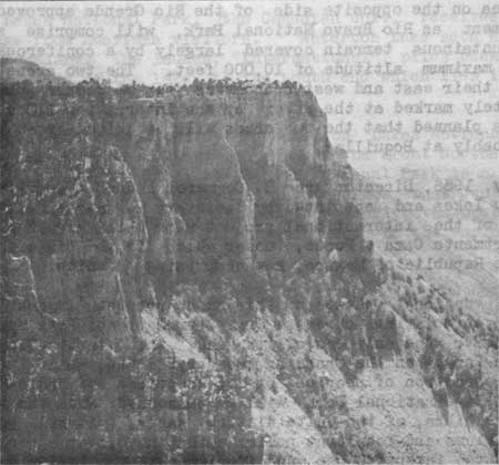
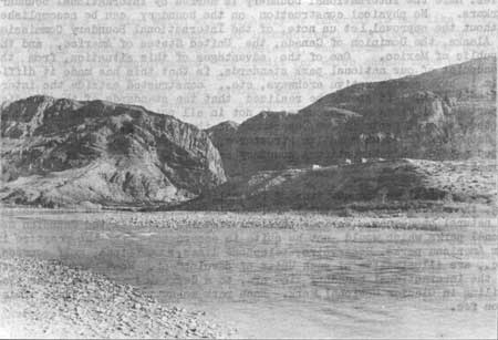
INTERNATIONAL AREAS By Herbert Maier, We had dismounted to let our horses graze for awhile. From the heights of the South Rim of the Chisos, the arduous meanderings of the Rio Grande flashed in the noon sun. Over on the Mexican side the San Hechiceros Range mounted through a thin blue haze against the horizon. "Uncle Everett" Townsend yanked the brim of his sombrero down over eyes that appeared as mere slits against the midday glare. "Somehow, I've always felt like you do about our friends across the river," he finally began. "I rode my horse over there before I was booted and spurred like a respectable Texan ought to be. Of course, after I got to be a ranger, and later, a sheriff, I only went over when the trail of some hombre got so hot on this side the only thing to do was to keep going. And many's the time a bullet clipped pretty close as I jogged along. We didn't have a right to cross in those days without a permit from the nearest Jefe, but at times like that we couldn't bother about a permit. "At such times I was glad for the kind way of those people and the friendships I had amongst them. They're just naturally hospitable and gracious, if you'll let me use that word. Of course, they live differently than we do; and they do business differently. They call it the 'Land of Manana', but Mexicans often use that word because it's kinder than just saying 'no'. But if you're in need or in danger, they'll always help you, no matter how much or how little they've got. You know, there isn't a bridge between Presidio and Del Rio and that's 350 miles." It requires a good stretching of the imagination to bridge the gap between a national park project in its formative study stage, and a concept of the area developed to a stage of reasonable use. From the social angle, the Big Bend International Park project offers intriguing potentialities far beyond that of any other national park project at present before the Service. This dual project will comprise the Big Bend National Park in Texas and The Rio Bravo National Park in the States of Coahuila and Chihuahua, Mexico. The American unit of 788,000 acres lies within the major bend of the Rio Grande in Brewster County in southwestern Texas. It is the only remaining wilderness area in the largest state in the Union. Its backbone, the Chisos (Ghost) Mountains, one of the southernmost spurs of the Rockies, is surrounded by an arid plateau having an elevation of 3,000 feet. From this base rise the Chisos Mountains to an altitude of 8,020 feet, a truly biological island covered with a varied and distinctive forest and floral growth that includes species only encountered again hundreds of miles to the north and east, and on the Pacific Slope. This area is the outstanding example in the United States of Mexican border land scenery. IN MEXICO'S BIG BEND
The area on the opposite side of the Rio Grande approved by the Mexican Government as Rio Bravo National Park, will comprise some 900,000 acres of mountainous terrain covered largely by a coniferous forest, and attaining a maximum altitude of 10,000 feet. The two areas are contiguous in that their east and west boundaries join at common points that have been definitely marked at the river by the International Boundary Commission. It is planned that the two areas will be joined by an international bridge, probably at Boquillas. In July, 1956, Director Arno B. Cammerer headed a committee, approved by Secretary Ickes and appointed by Secretary of State Hull, to work out the details of the international project with Chief Miguel A. de Quevado, of the Departmento Caza y Pesca, under which is the Division of National Parks of the Republic of Mexico, now comprising 36 units. The international phases of this major project suggest its most intriguing and stimulating aspects. True, our National Park System already includes a unit, the only one of its kind, the Waterton-Glacier International Peace Park, on the Canadian boundary. But, while the latter involves the recreation of peoples of two countries, of Anglo-Saxon origin, the Big Bend International Park will be concerned with the intermingling within a zone libra, of two quite distinct races. It will be well to review the problems and resultant policies that have, over a period of years, grown out of the intensive use and experience in the former area. On the Canadian boundary, within the Waterton-Glacier International Peace Park, the survey line is a "cleared" line separating the two countries. Here the international boundary is marked by international boundary markers. No physical construction on the boundary can be accomplished without the approval, let us note, of the International Boundary Commission of Alaska, the Dominion of Canada, the United States of America, and the Republic of Mexico. One of the advantages of this situation, from the standpoint of our national park standards, is that this has made it difficult to have commemorative archways, etc., constructed astride the international line. It should be realized that the standards of the Canadian Department of Mines and Resources do not in all points coincide with those of the national parks in our Department of the Interior. In any case, it is debatable if commemorative structures, archways, etc., should be located astride an international boundary separating the two units of an international park. There follows the question of fee collections, fire protection, grazing, the maintenance of natural ecological conditions and the preservation of natural phenomena. Various physical features occur in the Canadian national parks which would not be quite in accordance with the practice in our American parks. Reservoirs, telephone lines, stand pipes, golf courses, etc., are illustrative of such units of development. Road standards north of the international boundary line are, to a degree, lower than those prevailing in Glacier National Park. Each park maintains its separate admission fee. Waterton Lakes National Park, the Canadian unit, receives its principal patronage from American visitors. Waterton Lake sets astride the international boundary. The launch, "International", plies back and forth from the Canadian end of the lake to the south end which lies in American territory. The principal hotel development in Waterton Lakes National Park is owned and operated by a subsidiary company of the Great Northern Railway exactly as the Glacier Park Hotel in Glacier National Park is a subsidiary of the Great Northern Railway. Canadian law requires that Canadians be employed in the Prince of Wales Hotel, but, apparently, the operating company has obtained exceptions from this requirement in the employment of a manager and several other key employes. Since fire hazards in Waterton Lakes National Park are comparable to those in Glacier National Park, the park forces of each area evidence a very aggressive cooperation whenever fire occurs. Since the greatest menace is a fire which spreads from Glacier National Park to the Canadian area, the Canadian citizens extend effective help in suppressing fires on the American side. Canadian standards regarding the maintenance of natural ecological conditions do not coincide in many ways with our principles. Wildlife standards are not comparable. Grazing is permitted in Canadian national parks and predatory animals are killed. As a specific example, the Canadians kill bears because bears kill the cattle which are permitted to graze in the Canadian parks. There is a problem which will probably be inherent in any like international area, viz., the tendency of international service clubs on both sides of the boundary to dedicate, rededicate, and assume honor for physical structures and improvements, the credit for which should more properly go to the populations of either or both countries. Such dedications, if desirable, should represent all rather than a single service group, or, more properly, should be government sponsored. In view of similar areas that will be established in time along international boundaries of this and other countries, it is encouraging to note that administrative problems of the Waterton-Glacier International Peace Park have not been of a serious nature and have readily lent themselves to solution. Superintendent Libbey of Glacier National Park, recently stated, "The Canadian visitors to Glacier National Park represent a very high type of citizenship and their ethnic derivation causes them to be thoroughly in accord with the standards and social customs of our people. The Canadians, being respectful of law and regulation and obedient to law enforcement agencies, the problem of international relations here is an amicable one. It appears my predecessors at this park have been very solicitous in maintaining the very finest international relations, and I and my staff are just as anxious to maintain a continuation of such relations." But recreation is not the only principal consideration activating the establishment of international areas. Gratifying, indeed, to those interested in the establishment of international areas having historical significance is the provision included in the recent Congressional appropriation act for the Coronado Cuarto Centennial, authorizing the commission to establish an area which will be classified as an international monument on the Mexican boundary at the point where in 1540 Coronado first crossed into what is now the State of Arizona. To the National Park Service has been assigned the task of determining just where this crossing occurred and of recommending appropriate boundaries. The location of international areas need not necessarily be confined to international boundaries. There are located deeply within our country, those sites with which our past is intimately associated with deeds and lives of people of another nation or of several nations. Who can doubt that Williamsburg in Virginia has interest and importance to both the United States and Great Britain? Who can minimize the efforts of Spain in St. Augustine, Florida; and Spain and Mexico in the Southwest and in California; or the French background of the Mississippi Valley? Regional Historian Neasham, in a report covering proposed international historic sites, recently stated "The United States Government is desirous of bringing about closer understanding and cooperation between the nations of the world, especially those of the Western Hemisphere. More and more, it is becoming realized that the peoples of the twentieth century have a great deal in common. By emphasizing that which we nations do have in common, we point the way for a greater interdependency and mutual understanding." The proposed Big Bend International Park, a huge area within which the people of two countries may intermingle without the usual annoyances of customs and other international restrictions, will, indeed, promote a common understanding between neighboring races, now little known to each other. The National Park Service, as an agency of the United States Government, is doing its part in the program of stimulating international understanding and cooperation. | |
| <<< Previous | > Contents < | Next >>> | ||
|
http://www.cr.nps.gov/history/online_books/region_iii_quarterly/vol1-2g.htm Date: 17-Nov-2005 | ||||