|
NATIONAL PARK SERVICE
Pacific Coast Recreation Area Survey |

|
INTRODUCTION
The Survey
The specific objective of the Pacific Coast survey, as assigned to the survey team, was "to inventory and report on important remaining undeveloped areas, or areas with relatively sparse development, valuable for recreation and other public purposes, along the Pacific Coast." The term "recreation" was used in the broad sense to apply to areas of scenic, scientific and historical interest, as well as those chiefly valuable for active recreation.
In essence, it was the goal of this inventory of undeveloped seashore areas to select those areas that should properly be included in a well-rounded and adequate National Park System; the designation of areas that should be preserved for the welfare of the general public because of their scenic, cultural and scientific values, regardless of what agency or level of Government might administer them; and the identification of areas necessary to provide for active public recreation use and enjoyment by an expanding population.
The scope of the survey involved over 1,700 miles of general tidal shoreline, or from Mexico north to Cape Flattery and east to Tongue Point in the Strait of Juan de Fuca. There are various methods used for measuring the coastline, but the foregoing figure conforms with "general tidal shoreline" as defined by the United States Coast and Geodetic Survey. Also in conformance with that definition, the survey included the shoreline of all bays, sounds, and other bodies of water to a point where such waters narrow to a width of three statute miles at their inlet, including the distance across the headlands. Since the littoral line of the Pacific Coast ends at Tongue Point (10 miles west of Port Angeles, Washington) the shoreline west of this point is considered as open coast and the shoreline eastward as inland waters. Also included in the scope of the survey were the Channel Islands off the southern California coast. The total length of shoreline as thus defined is broken down as follows:
| Section of Coast | Miles of General Tidal Shoreline |
| California Coast (mainland) | 949 |
| Channel Islands | 241 |
| Oregon Coast | 312 |
| Washington Coast | 175 |
| Cape Flattery to Tongue Point | 66 |
| TOTAL | 1,743 |
Why the Survey
The National Park Service completed the Seashore Recreation Area Survey of the Atlantic and Gulf Coasts in 1955 and made public the general findings in a report titled Our Vanishing Shoreline. That survey was prompted by increasing interest in the startlingly small amount of remaining undeveloped seashore along the East Coast. The only reference available prior to the 1955 report was a similar study completed in 1935, but development on the eastern seaboard had expanded tremendously in the meantime, thereby making the former twenty-year-old study almost completely obsolete.
Our Vanishing Shoreline was distributed to many agencies and individuals on the Pacific Coast in 1956. People there also became concerned and asked the questions: "What are the conditions on the Pacific Coast?" "Are there many remaining undeveloped seashore areas on the western seaboard?" "If so, where are they located?"
The National Park Service had neither the staff nor the funds to conduct a study to answer those questions. Fortunately, as was the case with the East Coast survey, a generous donation of private funds was made available to conduct the Pacific Coast Seashore Survey. Accordingly, the Service assembled a small professional staff and undertook a one-year study of the coast and offshore islands from Mexico to Canada.
This report records briefly the history of the survey and attempts to classify and describe the individual areas that were identified.
|
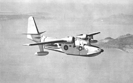
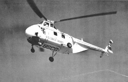
| The survey party examined the entire Pacific Coast and offshore islands from U. S. Coast Guard helicopter and fixed-wing aircraft. —U. S. Coast Guard Photo |
How it was Conducted
The problem that confronted the Pacific Coast survey was almost directly opposite to that of the Atlantic and Gulf Coasts. Because of the existence of extensive, undeveloped segments of the Pacific Coast, particularly in the northern coastal regions, the problem concerned the selection of areas of real significance, rather than that of finding any undeveloped areas, as proved the case in the earlier survey. To establish some sort of criteria on the west coast, therefore, beach areas with less than one mile of shoreline were ruled out unless special values were involved.
From the outset, it was obvious to the survey staff that a considerable amount of time would be required to gather background material, since this was the first survey of its kind on the Pacific Coast, and there were no prior reports available for comparison purposes. The problem was greatly alleviated by the splendid cooperation of the many federal, state, and county agencies, universities, colleges, and conservation organizations which were contacted and which provided the survey staff with available reports and other information in both written and oral form.
Armed with this background material, the survey staff, "took to the air." With the generous and cordial cooperation of the U. S. Coast Guard, the entire coast was examined from helicopters and fixed-wing aircraft. This important phase of the survey was to spot, photograph and note on charts and maps the significant areas that remained undeveloped. If a length of shoreline was observed to be undeveloped or at least only sparsely developed in relation to the density of improvements within the general vicinity, it automatically became eligible for consideration. During the air reconnaissance, however, many areas were eliminated from the survey because they were obviously lacking in those qualifications suitable for public recreation purposes.
After initial air reconnaissance, which was covered in sections, and while the information was fresh in mind, these identified and plotted areas were investigated on the ground for additional information and photographs. This was accomplished by automobile, power wagon, jeep and, in many instances where it was the only means of access, by foot.
In several cases, ground investigation proved that certain areas which had looked promising from the air did not possess the qualifications suitable for public use, and were dropped from further consideration.
All of the areas described in this report were visited by at least one member of the survey staff, the number depending upon the type of area. For practical reasons, the appraisals had to be based largely on the informed judgement of the survey technicians and others consulted, and they are therefore only relative.
|
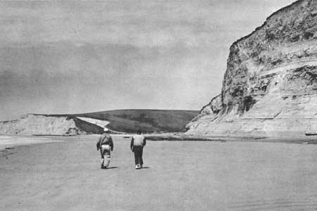
| All of the identified areas were visited on the ground, by automobile, power wagon or jeep. In many instances the only means of access was by foot. |
Insofar as possible, the following kinds of data were collected for each area:
I. Physiographic Features
A. Scenic values
B. Length and width of area or shore
C. Description and location of dunes
D. Extent and location of bays, lakes, and ponds
E. Topographical comments
F. Extent and location of marshes
G. Weather conditions
H. Beaches
I. Water - condition and description
J. Geology
II. Adaptability for Use
A. Present land use
B. Future - possible
C. Degree of deterioration caused by adverse influences
D. Roads in area
E. Accessibility
F. Relationship to areas of population
G. Relationship to areas of similar character
H. Notes on land values
I. Availability for public use
III. Recreation Potentiality
IV. Conditions Not Compatible to Recreation
V. Types of Habitat
A. Vegetation
B. Animal life
VI. Recreation Values Relating to Biology
VII. Breeding Grounds of Significance
VIII. Historical
IX. Archeological
X. Other Considerations
A. Aesthetic qualities
B. Shade
C. Unique species present
D. Uniqueness of habitat
E. Need for preservation
F. Adaptability for interpretation
G. Any unusual features
| <<< Previous | <<< Contents>>> | Next >>> |
rec_area_survey/pacific/intro.htm
Last Updated: 25-Jun-2007