|
NATIONAL PARK SERVICE
Great Lakes Shoreline Recreation Area Survey |

|
REMAINING OPPORTUNITIES IN WISCONSIN
|
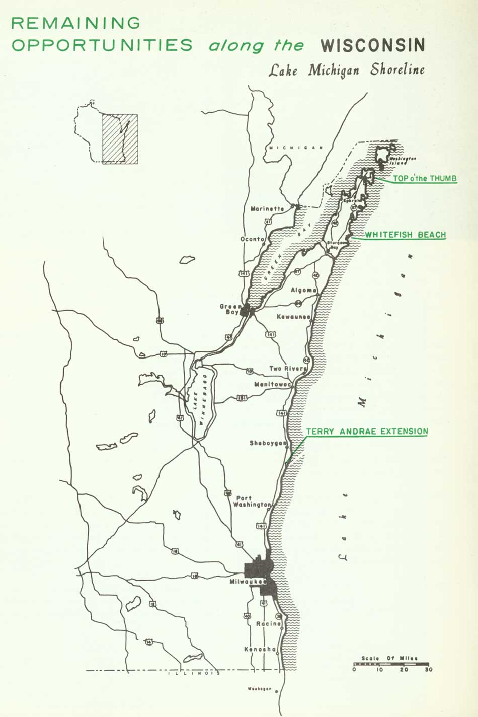
| Remaining Opportunities in Wisconsin — Lake Michigan Shoreline (Vicinity Map) (click on image for an enlargement in a new window) |
SUMMARY
Though Wisconsin extends only 200 miles north and south along Lake Michigan, the convolutions of the shore around the Door Peninsula, Green Bay and several islands add up to 495 miles. All but 70 of these are mainland miles, either on Green Bay or Lake Michigan. Three state parks, with a total of 6.9 miles of lake frontage and 4,864 acres, already exist along these shores. In addition, Point Beach State Forest, which serves recreation needs on a par with the parks, occupies 5.5 miles of frontage and encompasses 2,258 acres of forest and beach.
The shoreline has four segments sufficiently cohesive to merit individual discussion. From the Illinois state line to the base of the Door Peninsula is an area of eroding shore bluffs. Beaches, though primarily sand, are not very wide except at Terry Andrae State Park and Point Beach State Forest. The primary need is for additional frontage for Terry Andrae State Park. The park, with only .7 mile of lake frontage and 167 acres, is hardly adequate for the large crowds it attracts. Cottage development varies from heavy to sparse, depending largely upon the distance from Milwaukee, and farmland comes to the bluff edge along much of this stretch.
The Lake Michigan side of the Door Peninsula is the second shore region. In this region the shore bluffs eventually give way to rocky limestone shores and bays with sand beaches often backed by dunes--dunes primarily stabilized by forest cover. This is a scenic region with a pastoral charm that long ago made it a tourist mecca. The cold waters of Lake Michigan bathe this side of the peninsula and it is, consequently, several degrees cooler than the Green Bay shore. Nonetheless, as visitation increases, cottage developments are slowly but surely occupying the best recreation sites. This is an area that is going but not yet gone. Consequently, two study areas are recommended for this shore region.
The Green Bay shore of the Door Peninsula is more completely developed, with either farm land or summer homes occupying most of the shore. This is a scenic region with high shore bluffs and cliffs alternating with beaches and coves. Two fine state parks already exist here and, though heavily used, are attractive and natural in appearance.
The western shore of Green Bay is very low lying. The shores are sparsely vegetated with rushes and grasses, and sufficient sediment occurs in the sand to make the beaches not overly attractive for recreation. However, these low lying shores are important to--and heavily used by--migrating shore birds, and the marshes fringing the bay have great value for waterfowl. The Wisconsin Conservation Department presently owns considerable land on two of the more important marshes. Thus it appears that the significant conservation needs have been met.
| WISCONSIN Lake Michigan Shoreline |
TOP O' THE THUMB
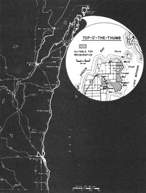
LOCATION Top-o'-the-Thumb encompasses the northeast tip of the Door Peninsula from Porte des Marts Strait south to the village of Rowleys Bay. This Lake Michigan shoreline is accessible by several county routes and State Route 42 from Sturgeon Bay, 45 miles to the south. A 10-mile shoreline fronts an interior area of 4,800 acres.
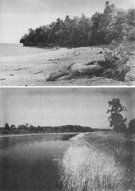
DESCRIPTION Scenic, resistive limestone fashions an irregular shoreline along Lake Michigan blending from bold points to broad bays. Sandy shores are frequently associated with some of the beaches, particularly at Newport and Europe Bays. Some small limestone pebbles are mixed in the gleaming sand but are not sufficient to detract from the bay's recreation value. Beaches of sand also occur on the eastern shores of Europe Lake. Here, only a narrow, mile-long sand dune well stabilized by pine, oak and maple separates Europe Lake from Lake Michigan.
The major portion of the area immediately back of the Lake Michigan shore is in forest growth. Though these forests have been cut over, there still remains a scattering of mature trees in the second growth forest. This cover is dominated by hardwoods such as maple and birch, along with a scattering of red and white pine.
Flowing into Rowley Bay is the deep clear water of the Mink River which drains the areas second inland body of water--the marshy Roger Lake. These waters reportedly support such game fish as pike and bass, while the stream edge is a favorite habitat of the great blue heron, other waders and shore birds.
PRESENT USE The Door Peninsula is famed as a cherry growing region, and it is this activity together with other agricultural uses that constitute the area's principal activities. Farmland borders the inland side of most of this proposed site. Summer cottage development in this region has become popular in recent years, foretelling a potential future activity.
ANALYSIS The Top-o'-the-Thumb possesses not only outstanding scenic and recreation qualities but forests valuable as windbreaks for the protection of interior crop lands. The management of these features could be adequately and desirably discharged by a state forest unit.
|
| Top O' The Thumb |
| WISCONSIN Lake Michigan Shoreline |
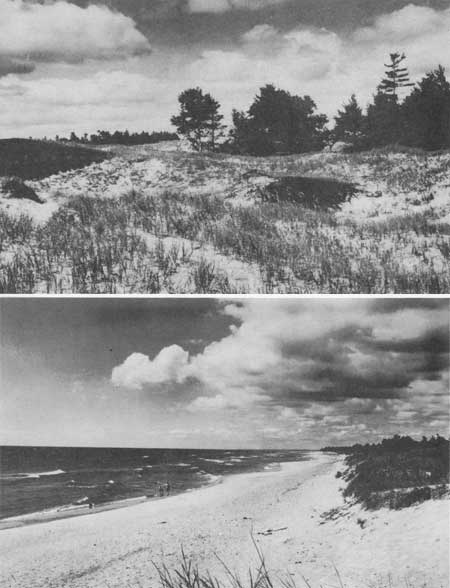
WHITEFISH BEACH
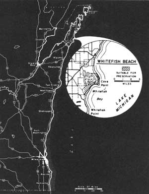
LOCATION Lying on the east side of the Door Peninsula, Whitefish Beach occupies the northern portion of Whitefish Bay between the Clark Lake outlet and Cave Point. State Route 57, together with branching county routes, provides access to this region from Sturgeon Bay 10 miles to the southwest. Statistically, Whitefish Beach and Cave Point comprise a shoreline of nearly 3 miles and an inland area of 700 acres.
DESCRIPTION Whitefish Bay is unique among Wisconsin's Lake Michigan shoreline features by virtue of its scenic setting surrounded by a rich recreational region. Cave Point and its low limestone bluffs are among the areas' scenic highlights. Undercut by Lake Michigan's wave action, these bluffs have been shaped as caves and arches. During stormy periods, bellows of thunder emit from the caves while the driving waves cause the surrounding earth to tremble.
South of the Point and behind the beach rise a series of sand dunes, some reaching nearly 50 feet above the Lake. Areas of raw sand are not common, though an occasional "blowout" stands above the beach. Covering the dunes are forests of mixed hardwoods and conifers with a carpet of small shrubs and wild flowers completing the dune mantle. The forests appear to reach their largest stature in the vicinity of Cave Point.
The presence of wide sand beaches is uncommon along the western shore of Lake Michigan, making their occurrence here an important recreational attraction. Whitefish Bay's fine white sands spread out as broad beaches up to 150 feet in width. Offshore, the bay waters are shallow with a sand bottom that undulates over several sand bars.
PRESENT USE Private cottage development has spread over a large segment of Door County's lower Lake Michigan shoreline with some of this development beginning along Whitefish Bay. At present, public ownership is confined to a small 18-acre county park embracing some of the scenic features on Cave Point.
ANALYSIS By virtue of the scenic charm and valuable recreation possibilities of Cave Point and Whitefish Beach, this area should be singled out for addition to the state park system. Its unusual features warrant public preservation at an early date before the opportunity is lost.
|
| Whitefish Beach |
| WISCONSIN Lake Michigan Shoreline |
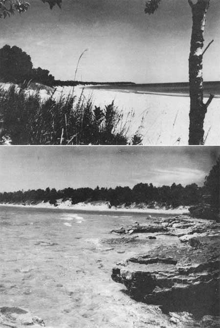
TERRY ANDRAE EXTENSION
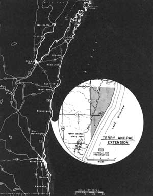
LOCATION Terry Andrae State Park is situated on the west shore of Lake Michigan about 40 miles north of Milwaukee and 5 miles south of Sheboygan. The proposed extension adjoins the park on the north. It includes 2 miles of shore frontage on Lake Michigan and approximately 1,000 acres of land. The region of park expansion is accessible via U.S. Highway 141 and connecting county routes V and KK.
DESCRIPTION The Terry Andrae extension contains one of the last remaining undeveloped sand beach and dune areas along Wisconsin's southern Lake Michigan shoreline. Characterizing this area is a broad beach measuring up to 100 feet in width. This beach, as well as the offshore bottom, is composed primarily of fine sand with a light scattering of small pebbles.
Behind the beach rises a low barrier dune partially stabilized by beach grasses and a few low shrubs. Farther inland is a narrow quarter-mile zone of low sand dunes that parallels the shoreline. These dunes seldom reach more than 20 to 30 feet in height, giving an uneven rolling pattern to the terrain. Stabilization of the dunes in the southern portion has been largely by beach grasses, while a denser forest cover clothes the northern half. The scraggly tops of white pine are prominent silhouettes above their forest associates throughout much of the region.
The Black River flows through a small marsh west of the existing state park and continues in a northeasterly direction along the west edge of the dunes. Black spruce, ash and alder thickets form a contrasting vegetative pattern to that found on the dunes.
PRESENT USE The existing state park, located close to the populus southeastern corner of Wisconsin, frequently experiences overflow crowds in its developed areas. A region containing only a limited cottage development lies north of the state park where suitable conditions exist for expanded bathing, camping and picnicking facilities.
ANALYSIS Achievement of optimum public use at a level that would avoid destruction of the park's intrinsic values can be best accomplished by dispersal of use over a larger area. The addition of this Lake Michigan frontage would be an important step toward the realization of better protection of park features and provision for greater public enjoyment.
|
| Terry Andrae Extension |
| <<< Previous | <<< Contents>>> | Next >>> |
rec_area_survey/gl/wi2.htm
Last Updated: 27-Jun-2007