|
NATIONAL PARK SERVICE
Great Lakes Shoreline Recreation Area Survey |

|
REMAINING OPPORTUNITIES IN MINNESOTA
|
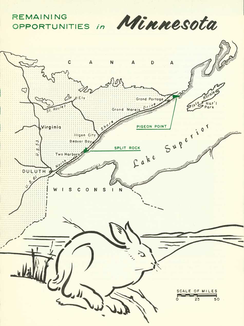
| Remaining Opportunities in Minnesota (Vicinity Map) (click on image for an enlargement in a new window) |
SUMMARY
Minnesota's North Shore of Lake Superior is outstanding. Nearly the entire shore is characterized by numerous lava flows interspersed with dikes and sills of durable igneous rock. These formations--often spectacular and always picturesque--are part of the Keweenawan rocks, so named for similar exposures on Michigan's Keweenaw Peninsula on the south side of the lake. Older Huronian rocks occur at Pigeon Point just south of the Canadian border and are of great geologic interest. Back from the shore, the land slopes up steeply to a mountainous divide, in places over 2,000 feet above sea level. This landscape has resulted in a scenic, irregular shoreline, deriving its principal attractions from the sweeping views of the lake, imposing shore cliffs, thundering waterfalls and rugged terrain.
From Duluth to the Canadian line, U.S. Highway 61--the North Shore Drive--follows, as closely as practicable, the undulations of this shoreline for approximately 150 miles. Expanding private and commercial developments along this highway have pre-empted much of the shore line. The Minnesota Division of State Parks administers 11 areas along this route. Gooseberry Falls State Park has good campground facilities. Less highly developed campgrounds are provided at Temperance and Cascade River State Parks, and potential for future campground developments exists in others. The Highway and Conservation Departments have numerous strategically located picnic areas along the entire route. In many instances, foot trails have been developed for parking areas along the highway to scenic vistas and points of interest. The drive also passes through 40 miles of Superior National Forest, but the Forest Service owns only about two miles of lake frontage along this route. The authorized Grand Portage National Monument will be readily accessible from the relocation of the drive at its northern terminus at the Canadian boundary. Altogether, publicly owned shoreline amounts to about 19 miles, or roughly about 10 percent, of Minnesota's mainland and island Lake Superior shoreline.

The few beaches that occur in coves and at river outlets are gravel rather than sand. However, this is no particular deterrent because the cold waters of Lake Superior discourage all but the heartiest swimmers. Sport boating, that rapidly expanding recreational pastime elsewhere, is still a minor activity along this rugged shoreline--limited primarily by the treacherous waters of Lake Superior and an insufficient number of refuge harbors. Scenic enjoyment, along with camping, picnicking and hiking in this refreshing, pollen free atmosphere, are still the principal and growing recreation uses of the North Shore.
The existing state parks, plus the North Shore Drive with its recreation access and vistas, have gone a long way toward providing public enjoyment of this important segment of the Great Lakes scene. However, further steps are needed to preserve the scenic integrity that is there. Industrial, commercial and residential development have already consumed over one-third of the shoreline, thus eliminating public enjoyment of the encompassed scenery, waterscapes, and shoreline. Uncontrolled expansion of such development poses a threat to future enjoyment. What is needed is zoning control designed to protect the integrity of the more scenic reaches and provide a harmonious blending of structures and landscape.
Another means for protecting the integrity of existing features and increasing the carrying capacity of this recreation wonderland is through expansion of existing state areas. Most of the prime scenic and scientific features in back of this magnificent shoreline are protected by state ownership; but, in many cases, additional shore frontage would enhance the over-all enjoyment of these areas. Expansion of inland holdings around the scenic features would provide adequate buffers against conflicting uses and also furnish space for development of additional camping and picnicking areas to meet the steadily increasing demands for these facilities. An increase in area would also provide a better opportunity to eliminate the hazardous conditions existing at those parks where pedestrians are obliged to cross the highway at grade to reach trails to the waterfalls the parks protect.
Specifically, recommendations for treatment of the North Shore Drive and acquisition of the outstanding natural areas at Split Rock and Pigeon Point follow on the succeeding pages. Administrative decisions relative to these areas will be dependent on further studies recommended at both the state and federal levels.
|
|
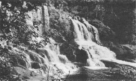
GOOSEBERRY FALLS STATE PARK (Lower Falls) |
| MINNESOTA |
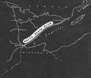
NORTH SHORE DRIVE
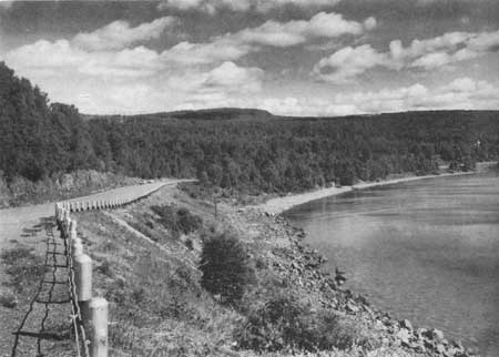
U. S. Highway 61, the North Shore Drive, was built in the early 1920's primarily to provide motor access to the lake shore villages. To a degree, its recreation potential was also recognized in right of way purchase for highway overlooks and wayside areas. However, expanding private and commercial developments along its borders are seriously threatening its continued usefulness as a public recreation road.
Such development is a major concern not only to the Department of Conservation but also to the Department of Highways. In this region of outstanding scenic, historic and geologic interest, the North Shore Drive is an important attraction for tourists. It also plays an essential role in tying together, as a unit, the many recreation features of the Lake Superior North Shore. Because of this, some form of parkway treatment is suggested. This concept is further strengthened by Canada's new highway being constructed around the north shore of Lake Superior which will result in much greater tourist traffic.
A special study was conducted to evaluate the feasibility of developing a national parkway along this route. To meet national parkway standards, it would be necessary to provide a commercial highway on the landward side of the parkway and a frontage road between the parkway and the privately developed sections of the lakeshore. It was concluded that private and commercial development was already too extensive and topography too restrictive in many places to permit development of such standards.
Instead, it is recommended that a parkway-like development be made similar to those for the Great River Road along the Mississippi River. To accomplish this, the following steps are suggested:
1. The Department of Highways and the Department of Conservation should collaborate in preparing a master plan to govern development of the North Shore Drive and the parks as a unit.
2. Each organization could then prepare detailed studies in accordance with the master plan and the Great River Road standards.
3. The Department of Highways would be expected to acquire right of way and the Department of Conservation to acquire additional park lands.
4. Development and improvements could then await the demands of traffic and visitation.
|
| North Shore Drive |
| MINNESOTA |
PIGEON POINT
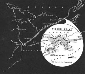
LOCATION Pigeon Point lies adjacent to the Canadian Boundary on the north shore of Lake Superior and forms the "point" of Minnesota's "Arrowhead Country." It may be reached by car over U.S. Highway 61 and a side road to Grand Portage. Access to Pigeon Point itself is possible only by boat and foot trail. However, planned relocation of Highway 61 will pass through part of the study area.
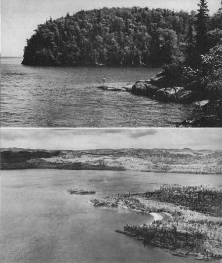
DESCRIPTION Pigeon Point, with its 30-mile shoreline and over 6,000 acres of wild land, comprises some of Minnesota's most rugged lakeshore landscape. Massive intrusions of diabase, an igneous rock, rise nearly 700 feet above Lake Superior and are covered by trees typical of the northern coniferous forests. White cedar swamps, together with other marshlands, are found throughout the area, and one small lake is present. Deer, bear and, occasionally, moose are found here together with their smaller associates of the northern forests. The picturesque shores of Pigeon Point and its offshore islands are marked by bold rock outcrops, some forming sheer cliffs rising over 100 feet above the water, while elsewhere the rock-clad edge is broken by gravel beaches. One of the principal scenic features is Wauswaugoning Bay and the high cliffs bordering its west and north shores.
The 101-foot Pigeon Falls will be a distinctive, climactic feature of the realigned North Shore Drive. The Pigeon River, forming the International Boundary between the United States and Canada in this region is characterized by many high waterfalls and rapids. This made the lower Pigeon River an obstacle to the early fur traders and trappers, and necessitated the location of a portage route. Thus the "Grand Portage" route through a pre-glacial valley came into use, and today lies within the adjacent Grand Portage Indian Reservation. On the offshore islands, evidence of recent and prehistoric mining operations are still evident.
PRESENT USE Today the area is used only as a sporadic hunting ground and intermittent base for declining fishing operations. A major portion of this land is being held in trust for the Grand Portage Band of Chippewa Indians and, as such, is considered private property. Only negligible acreages are in public ownership.
ANALYSIS Pigeon Point is one of the largest undeveloped areas on Minnesota's Lake Superior shoreline and, because of its terrain and location, has a relationship with the events surrounding the "Grand Portage." Its possible national significance should be studied further, along with all lands from the tip of Pigeon Point westerly to the east boundary of the Superior National Forest.
|
| Pigeon Point |
| MINNESOTA |
SPLIT ROCK
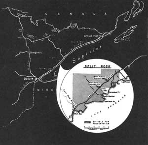
LOCATION Split Rock's bold, rocky headlands rise above the chill waters of Lake Superior approximately 45 miles northeast of Duluth, Minnesota. Access to this region is provided by U.S. Route 61, the "North Shore Drive," which parallels the Lake Superior shoreline between Duluth, Minnesota and the Canadian border. Southward from the Split Rock Lighthouse, a waterfront of 3.3 miles and an inland area of 1,200 acres are included in this proposal.
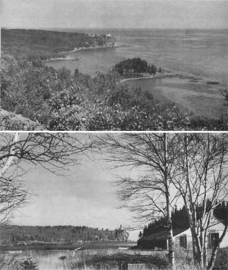
DESCRIPTION The shore character around Split Rock is dominated by sheer rock cliffs and boulder-lined bays. Atop one of these headlands stands the Split Rock Lighthouse--the unofficial symbol of the North Shore. The picturesque structure holds a fascination for tourists and natives alike, while its flashing light and foghorn warn mariners of the dangers along this shore during violent storms.
A small rocky point curves partially around East Bay, forming another of this area's scenic shore features. Except for a narrow connecting link of cobblestones, the bulk of this point would be an island of low, rough outline. Contrasting the dark green of the coniferous cover are the orange lichens that cling to some of the rocks that lie awash during storms.
Back of the mainland shore, the land rises moderately to knobs some 200 feet above the lake. From these points, vistas open toward the expanse of Lake Superior and the associated jagged shoreline. A young second growth forest covers most of this region. Birch and aspen are frequently encountered along with a mixture of pine, fir and spruce.
PRESENT USE A small, state scenic wayside presently preserves the view from atop Day Hill. A short trail connects this site with the North Shore Drive, whose right of way passes less than a mile from the shoreline. Some private development has taken place along the highway but the shoreline remains undeveloped.
ANALYSIS Split Rock, its lighthouse and the associated rough and scenic shores are some of the highlights of Minnesota's Great Lakes environment. By virtue of these features and its association with the North Shore Drive, it is recommended that the present state holdings be enlarged to develop this whole study area as a state park.
|
| Split Rock |
| <<< Previous | <<< Contents>>> | Next >>> |
rec_area_survey/gl/mn.htm
Last Updated: 27-Jun-2007