|
NATIONAL PARK SERVICE
Great Lakes Shoreline Recreation Area Survey |

|
REMAINING OPPORTUNITIES ALONG THE MICHIGAN LOWER PENINSULA (Lake Huron - Lake Erie Shorelines)
|
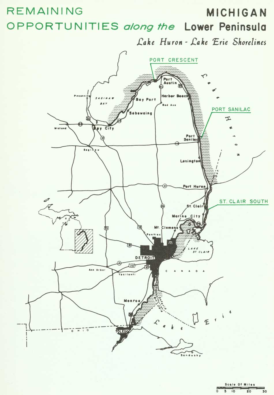
| Remaining Opportunities along the Michigan Lower Peninsula — Lake Huron - Lake Erie Shorelines (Vicinity Map) (click on image for an enlargement in a new window) |
SUMMARY
The focal point of Michigan's southeastern shoreline is the sprawling metropolis of Detroit. Not only is its great expanse visibly discernible but an even larger area is cast under the shadow of its influence. From the Michigan-Ohio state line, the shoreline winds northward past the developments along western Lake Erie, the waterfront industries of the Detroit River, the private estates of Lake St. Clair and, finally, the private developments of the St. Clair River and Lake Huron.
Southeastern Michigan has seen this extensive shoreline swallowed up in development. Some of this was inevitable because industry and commerce have needs and requirements for water frontage. But along with these commercial uses came private developments that spread rapidly along the shorelines, pre-empting beaches that once were unspoiled and available to every one. This situation is not unique to Detroit and its environment alone, but rather this has been the almost universal story wherever development has suddenly exploded to spread and engulf the land. Roads, utilities and home sites were laid out and crammed together to get the most from the land; but, all too often, open space designed for the refreshment of mind, body and spirit were forgotten. Parks and other recreation lands meant curtailed profits from these developments. But today the pendulum may be starting to swing another direction, for open space is important and the profits once thought to be lost from the elimination of a building site are no longer forfeited. Rather, a distinct contribution is being made to man's well-being in a different sense--one difficult to express in dollar values.
Along this 427-mile shoreline there are now approximately 55 miles in public ownership, of which 40 miles are devoted to wildlife areas primarily in the marshes along Lakes Erie and St. Clair and Saginaw Bay. The remaining 15 miles are set aside as parks, 10 of which are in the Detroit area.
To these public areas it is recommended that nearly eight miles of shoreline be added, half of which would lie along and between Lakes St. Clair and Erie. This would make a valuable contribution toward meeting the recreation needs of Detroit. Elsewhere, several small sites were studied on the St. Clair River and lower Lake Huron. The largest and finest of the areas recommended was found near the tip of the Lower Peninsula's Thumb on Lake Huron; the sandy beaches and hinterland of Port Crescent must take their place among the best on Lake Huron.
Today, these unspoiled areas are a partial answer and a means for achieving the goals that will satisfy the public's need for recreation sites. But, deliberate speed and action must be directed toward saving them in their unspoiled state to assure their availability for public use. Failing this, tomorrow we will face the costly problem of reclaiming from development that which we failed to fully appreciate yesterday and today.
| Lower Peninsula of MICHIGAN (Lake Huron - Lake Erie Shorelines) |
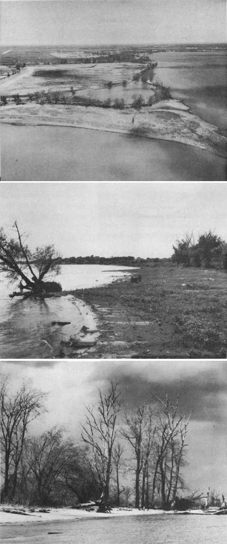
PORT CRESCENT
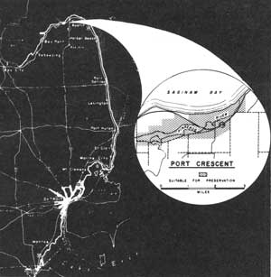
LOCATION The Port Crescent beach lies 6 miles southwest of the tip of the Thumb of Michigan's Lower Peninsula. State Route 25 parallels this shore generally less than a mile inland as it connects Port Austin with Bay City. The study area has a shoreline slightly in excess of 2 miles and an interior area of nearly 2,000 acres, primarily along the Pinnebog River.
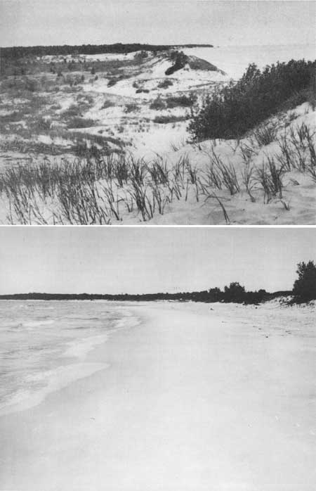
DESCRIPTION Some of Lake Huron's finest sand beach is located at Port Crescent near the southern entrance to Saginaw Bay. The quality is further enhanced by its contrast to the surrounding marshy shores of Saginaw Bay and the shallow, boulder-strewn waters along southern Lake Huron.
Though small, flat sandstones occur often near the eastern end of the shore, the western portion has an excellent beach composed of fine sand. Measuring nearly 100 feet in width, these beaches slope gently to the water line and beyond. Offshore, the shallow water frequently does not reach a depth of six feet less than 200 feet from the beach.
Behind the beaches rise a line of dunes, some over 20 feet high. The lake face of these dunes is nearly bare, while grasses and an occasional cottonwood anchor the sands on the inland slopes. Farther from the shore, a pronounced series of parallel sand ridges left from old beach lines are clearly discernible.
A large portion of the area between the lake and the Pinnebog River was at one time cleared, leaving only scattered young jack pines, cottonwood and other dry-site plants on the sand ridges. Today, in the wet swales between the beach lines and along the Pinnebog River, birch, maple, elm, ash and other hardwoods are found. A denser forest growth occurs south of the Pinnebog River and State Route 25.
PRESENT USE Numerous private properties exist through the inland area while a major portion of the shore frontage is owned by a sand excavating company. Only a small fraction of the area proposed for state park purposes is now in public ownership.
ANALYSIS The exceptional quality of the beaches at Port Crescent, in addition to suitable sites for other recreation pursuits, indicates strongly the need to complete public acquisition of private lands within the proposed Port Crescent State Park boundary.
|
| Port Crescent |
| Lower Peninsula of MICHIGAN (Lake Huron - Lake Erie Shorelines) |
PORT SANILAC
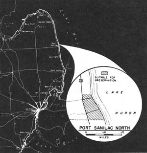
LOCATION This small area lies 1-1/2 miles north of the community of Port Sanilac along Lake Huron's southern shore. Paralleling the shoreline between Port Huron and Port Austin, U.S. Highway 25 passes within one-quarter mile of the lake in this study site. Port Sanilac North has a half mile of lake frontage and an inland area of approximately 50 acres.
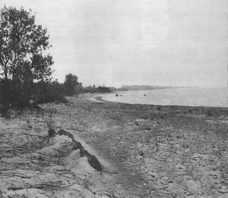
DESCRIPTION The southern shore of Lake Huron has few areas suitable for public recreation. A considerable portion of the shoreline is characterized by low bluffs of clay and sand, but occasionally the bluff outline disappears and a lower shore profile takes its place. This has happened north of Port Sanilac in the vicinity of this study area.
A beach less than 50 feet wide lies along this shoreline. Sand and gravel are the principal beach components while the occurrence of small boulders, in some sections, is noticeable. The gradient of the beach is shallow with a similar slope extending offshore. The shallow water that borders this site may extend as much as 1,000 feet offshore before reaching a depth of six feet. Boulders may be found interspersed over the sand and gravel bottom.
Behind the beach the land rises in an irregular pattern nearly 50 feet through a zone one-quarter mile from shore. All of this area has been cut over, leaving only scattered cottonwoods, white cedar, aspen and willow among a number of shrubs and herbaceous plants.
PRESENT USE This site is surrounded by private development. Several private homes have been constructed within the study area, and the possibility of additional development is not remote. Its nearness to Port Huron, and even Detroit, makes it desirable for private lakeshore uses.
ANALYSIS Because of its location in a region generally lacking in lakeshore recreation possibilities, Port Sanilac North takes on a more important aspect than it would amid the finer sites of northern Lake Huron. The area is nevertheless suited for such day use activities as picnicking and limited bathing. Developed along these lines, it could contribute to the local park needs of the surrounding region.
|
| Port Sanilac North |
| Lower Peninsula of MICHIGAN (Lake Huron - Lake Erie Shorelines) |
ST. CLAIR SOUTH
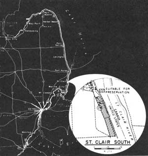
LOCATION Lying near the midpoint of the St. Clair River, this site is less than one mile south of the community of St. Clair. Michigan State Route 29 closely parallels the river bank from Algonac to Port Huron, providing easy access to the water. Between the highway and the river, this undeveloped site is approximately .8 mile long and contains 45 acres.
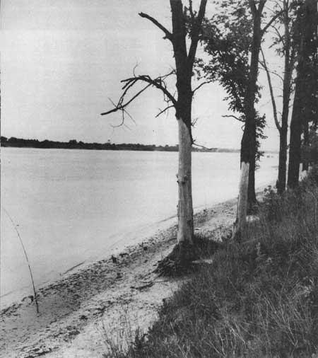
DESCRIPTION The narrow shores lining the 39 miles of the St. Clair River are subject to inundation during high water. The sandy strand that lies along the river is seldom more than a few yards wide. Offshore, the river bottom drops off sharply to depths of 26 to 48 feet in the river channel.
Behind the low shore, a bluff averaging 15 to 20 feet in height rises rather abruptly and then follows a level plain west to the highway. Nearly all of the area has been cleared with only a few trees lining the river bank and occupying several other scattered lo cations.
The passage of Great Lakes shipping so close to shore provides an attraction for this site since few areas lie so close to the shipping lanes.
PRESENT USE Private development has taken place at both the north and south limits of this area; while, within a limited portion of this tract, a sand and gravel removal operation has been active. These uses appear to be the extent of activities that might affect a public use area in this locality. Considerable informal fishing use takes place along this section of the St. Clair River by private parties.
ANALYSIS The river bank below the community of St. Clair is ideally suited for a state highway roadside park, where a view of passing Great Lakes ships and ocean-going vessels would be the principal attraction. Developed to the same high standards of Michigan's roadside park system, this would provide a restful stop for motorists as well as being a local recreation outlet for fishermen.
Sharing this location with the roadside park could be a public fishing site. This use is already well represented, and efforts should be made to insure the public's access to the river in this locality.
|
| St. Clair South |
| Lower Peninsula of MICHIGAN (Lake Huron - Lake Erie Shorelines) |
DETROIT
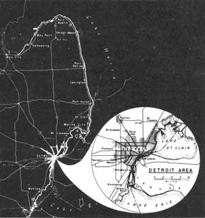
Second only to Chicago in size, the Motor City creates one of the major recreation use impacts in the Great Lakes region. Here, nearly 3-1/2 million people--many of whom spend their working hours in the limiting confines of industrial employment--need and are entitled to outdoor recreation diversion.
Inland, much has been done to meet these needs. However, public recreation lands are particularly limited along Lake St. Clair, the Detroit River and western Lake Erie. Along this shoreline (which totals 212 miles of mainland and island frontage), less than 5 percent is devoted to recreation, and the four miles of beach at Sterling Monroe State Park and Metropolitan Beach provide less than one-tenth of an inch of shoreline per person living in the metropolitan area. In or near large centers of population, 20 percent is considered an absolute minimum for public recreation frontage.
Available land for conversion to recreation use is a real problem in the Detroit area. Residential and industrial developments are the primary consumers of waterfront. In most cases, these developments are too intensive for practical consideration of public acquisition. In fact, with the advent of the St. Lawrence Seaway, industrial water front expansion may be justified. However, the existing structures in many residential areas have passed their peak of efficient usefulness and, in some instances, have become unattractive liabilities to the over-all area, thereby decreasing general land values. In these latter examples, it is recommended that such sites be rezoned to recreation use and acquired while property values are at a minimum.
Since the primary objective of this Survey was to inventory undeveloped shoreline areas, little opportunity was available for close evaluation of obsolete land uses for conversion to recreation. However, it was felt that the Survey would be remiss to completely ignore the problems of shoreline already "vanished." Consequently, after consultation with the Detroit Metropolitan Area Regional Planning Commission, the Survey team examined suggested sites and recommend for public acquisition and conversion to recreation use: (1) the shoreline east of Selfridge Air Force Base; (2) a one-third mile strip of undeveloped shoreline one-half mile west of Metropolitan Beach; and (3) the two miles of undeveloped frontage east of Rockwood, north of Milleville Beach. These recommendations should be considered as minimum objectives, and continuing efforts should be made to search out and convert more shoreline to public recreation benefit.
|
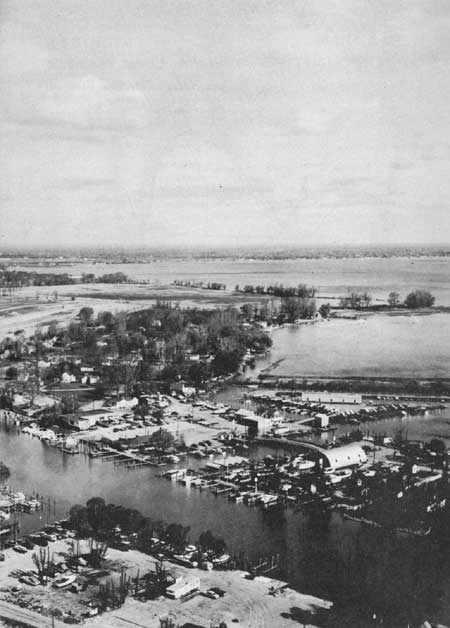
| Detroit Areas |
| <<< Previous | <<< Contents>>> | Next >>> |
rec_area_survey/gl/mi6.htm
Last Updated: 27-Jun-2007