|
NATIONAL PARK SERVICE
Great Lakes Shoreline Recreation Area Survey |

|
REMAINING OPPORTUNITIES ALONG THE MICHIGAN LOWER PENINSULA (Lake Michigan Shoreline)
|
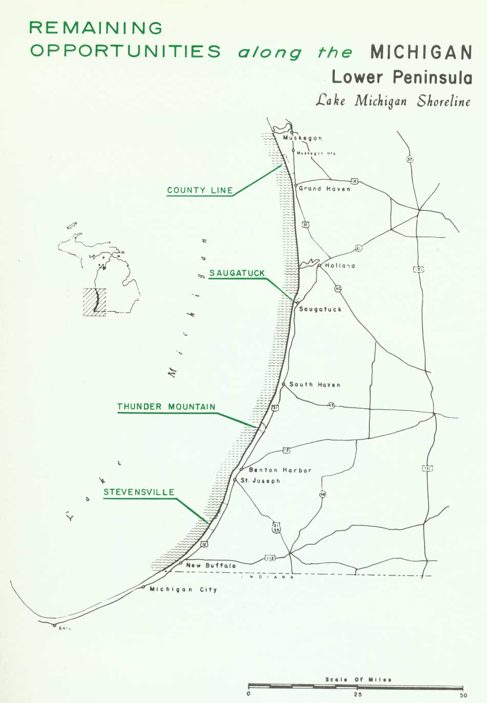
| Remaining Opportunities along the Michigan Lower Peninsula — Lake Michigan Shoreline (Vicinity Map) (click on image for an enlargement in a new window) |
SUMMARY
Often referred to as the "Riviera of the Great Lakes," this southeastern Lake Michigan shoreline rivals its European namesake in many ways. The turquoise waters resemble the Mediterranean color, and the whole area is widely known as a summer resort for residents of metropolitan Chicago and Detroit. Missing, however, are the noted casinos generally associated with southern France.
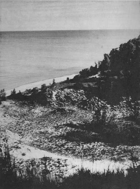
This southern Lake Michigan shoreline is almost a continuous sand beach bordered in sections by bluffs and elsewhere by high sand dunes. Along the bluffs, erosion is frequently a serious problem, particularly during high lake levels and stormy periods. Low barrier dunes protect the dune regions from the ravages of storms and serve to reduce the effects of erosion. Dunes in some locations rise over 200 feet above the lake and form a parallel ribbon of sand hills averaging approximately a mile in width. Though numerous dunes have been stabilized, the lake sides of many dunes have large "blowouts" cut by the persistent west winds. Shaped like amphitheaters in the shifting sands, these dunes are hard-pressed to provide a suitable foothold for vegetation. On the leeward side, protected from the dune-cutting winds, forests of deciduous trees have become established. Evergreens occur only sporadically, many lying near the southern limits of their natural range.
The scenic appeal of this region can only be rivaled by its recreation values. When the prevailing westerly winds blow surface water toward this shore, the warm water temperatures combine with the sandy beaches to promote ideal swimming conditions. Within reach of large metropolitan areas, the impact on the existing recreational facilities of this region is tremendous. Better than 7,000,000 people reside within a 50-mile radius of this region, including much of the Chicago metropolitan area.
Along this 110-mile shoreline are three state parks--Warren Dunes, Holland and Grand Haven. The shoreline of these three parks totals less than three percent of the lake front. In 1957 these three parks received an attendance of 3,250,000 or 19 percent of the total Michigan state park visitation.
Fortunately, some outstanding undeveloped shoreline remains in this region. Over 14 miles of shoreline have been selected as suitable for preservation and public use. Divided into four areas, these 14 miles of frontage would lift to 15 percent the amount of this shoreline in public ownership. To meet the recreation needs within a highly populated region, this percentage can be considered only a minimum. Unfortunately, a large portion of the remaining beach that would be suitable for recreation is now in various stages of private development and, consequently, unavailable.
Acquisition of these proposed areas is considered to be of extreme importance in order to meet pressing recreation demands as well as to protect the basic natural values of existing parks--particularly Warren Dunes.
| Lower Peninsula of MICHIGAN (Lake Michigan Shoreline) |
COUNTY LINE
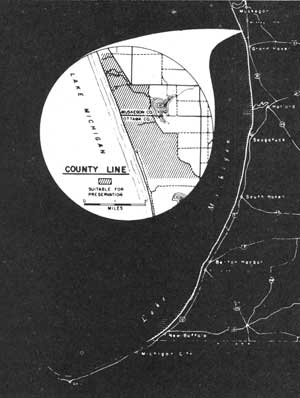
LOCATION Straddling the Ottawa-Muskegon county lines, this site lies less than four miles north of Grand Haven. Access to the shore is limited, but county routes parallel the inland edge of the sand dunes and connect with U.S. Highway 31 between Grand Haven and Muskegon. The total undeveloped shoreline amounts to 2.6 miles in addition to a 2,500-acre inland dune region.
DESCRIPTION A massive sand dune complex extends as a one-mile wide ribbon along the Lake Michigan shore and strikes a sharp contrast to the gently rolling inland region to the east. Some of the dunes reach heights of nearly 200 feet above the lake level, though the average height is closer to 150 feet. These dunes are primarily stabilized; however, occasionally "blowouts" occur where the eddying wind currents cut into and move the loose sands about the open amphitheaters. It is these areas of bare sand and their dissimilarity to the surrounding woods that impart to the region much of its scenic significance.
Forests of second growth sugar maple, beech, cherry, white ash and other hardwood associates are found over large portions of the stabilized dunes. Threatened by the eroding winds along the dune's shore face, the vegetation here struggles to maintain its foothold. Elsewhere, the forest growth finds some protection in the steep dune valleys, threatened only by the landward movement of the sand from the "blowouts."
The sand beaches are composed of fine, clean sand and vary in width from 50 to 100 feet. Shallow water extends offshore up to 200 feet before reaching a depth of six feet. Set before the picturesque dunes, these beaches offer exceptional locations for water recreation activities.
PRESENT USE Subdivision development is threatening this area from the south. Consider able development has already taken place, eliminating the three and one half miles of connecting shoreline with Grand Haven. Behind the dunes and near Little Black Lake is a country club and associated golf course; otherwise, the area is primarily in wood land or cultivation. The Norton Township Park lies adjacent to the area's northern boundary.
ANALYSIS The County Line study site offers some of lower Lake Michigan's finest remaining undeveloped shoreline. The outstanding beaches in conjunction with inland sites for picnicking, camping and nature study give this area the potential for an excellent state park.
|
| County Line |
| Lower Peninsula of MICHIGAN (Lake Michigan Shoreline) |
SAUGATUCK
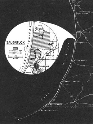
LOCATION This sand dune area lies adjacent to the mouth of the Kalamazoo River near the village of Saugatuck. Access to the region is by connecting state and county routes from U.S. Highway 31. The study area's 2-1/2-mile shoreline and 1,400 acres of sand dunes are split into two sections by the Kalamazoo River.
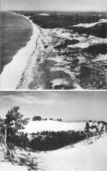
DESCRIPTION Saugatuck's most extensive dunes lie north of the Kalamazoo River, though several towering dunes occupy a narrow strip south of the river mouth. The northern sand complex is a series of dune "blowouts" extending over a mile inland. The westerly winds ceaselessly tear at these "blowouts", continually reshaping and moving the sand forms. The inland side of the dunes drops abruptly, delineating the east-west advance of the sand. Here, in the lee of the dunes, trees have become established in their attempt to contain the sand's movement.
In this dune region there is found a variety of tree species; conifers are common, including a few hemlocks and white pine. Red oak, sugar maple and beech occur through out the area along with basswood, sassafras and other deciduous trees.
Separating the sand from the beach is a low barrier dune. Tree growth occurs over segments of this dune, while elsewhere beach grasses provide stabilization. Resting before the barrier dune is a beach composed of fine sands. Varying with the lake level, this beach may range in width up to 150 feet or more. Similar fine sands are found offshore, being particularly evident in the sand bars that lie parallel to the shore.
PRESENT USE Cottage developments have occurred at the limits of this site, but a lack of access within the area has kept nearly three and one-half miles of shoreline undeveloped. In the south unit below the Kalamazoo River, a radar station is located atop one of the dunes. Dunesmobiles operate over the dunes north of the river, providing visitors an opportunity to see the region more intimately.
ANALYSIS By virtue of its fine beaches and scenic hinterlands, Saugatuck has a high public use value. Immediate steps should be taken to safeguard these values in order to meet the recreation demands of this region.
|
| Saugatuck |
| Lower Peninsula of MICHIGAN (Lake Michigan Shoreline) |
THUNDER MOUNTAIN
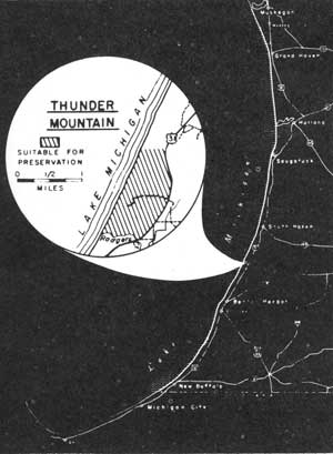
LOCATION Thunder Mountain lies on Lake Michigan's eastern shore nearly 11 miles north of Benton Harbor and 9 miles south of South Haven. These two communities are connected by U.S. Highway 31 which parallels the shore approximately one mile to the east. A study area shoreline of 1.7 miles extends north from Rogers Creek and intercepts an inland region of approximately 500 acres.
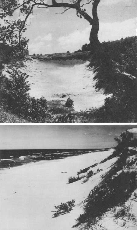
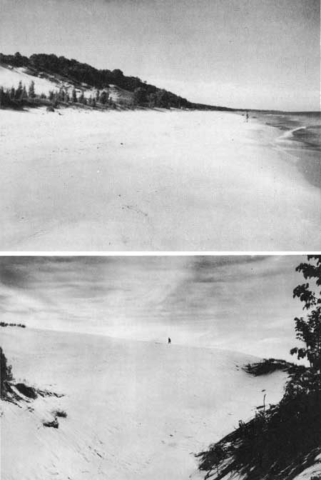
DESCRIPTION Thunder Mountain, rising above Rogers Creek, is one of the highest dunes along Lake Michigan's southeastern shore. Reaching over 200 feet above the lake, these dunes cover an area more than a mile wide along the shore. Several of the dunes are characterized by large "blowouts" carved and shaped by the prevailing westerly winds. Occasionally, sands are whipped about and carried over the ridge to move slowly inland. These raw sands contrast sharply with the more vigorous forest growth found behind the dunes.
The beaches lying before a partially stabilized, low barrier dune are better than 150 feet wide in places. Fine sands with a light mixture of small pebbles are the textural components of this beach. Similar material extends offshore and provides a useable site for swimming and other water recreational pursuits.
The forests found at Thunder Mountain include fine examples of second growth trees. White pine along with northern white cedar are the principal conifers, but they comprise only a small segment of the overall forest growth. Being primarily a deciduous forest, a few of the northern species such as sugar maple and birch have become established, while a number of more southern species, including the yellow poplar and sassafras, are present.
PRESENT USE Cottage development has occurred in this vicinity where access to the shore is possible. Though much of the building has taken place outside the recommended area, a few intrusions are found inside this site, along with some new construction.
ANALYSIS Thunder Mountain combines many recreational attractions within its limits. It possesses high scenic qualities, desirable swimming beaches, suitable areas for picnicking and an interesting scene for nature study. By virtue of these qualities, this site should be given early consideration for public acquisition of the beach and dune areas.
|
| Thunder Mountain |
| Lower Peninsula of MICHIGAN (Lake Michigan Shoreline) |
STEVENSVILLE
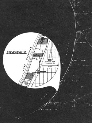
LOCATION Lying near the southeastern tip of Lake Michigan, the Stevensville site is approximately 12 miles north of the Michigan-Indiana State Line. The principal access route is U.S. Highway 12 which parallels the shore nearly a mile inland between Michigan City, Indiana and Benton Harbor, Michigan. The 2,000 acres and the 4-mile shoreline of this study area are broken into three separate units stretching 7 miles north of Warren Dunes State Park.
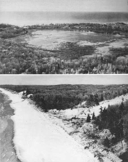
DESCRIPTION The Stevensville site is characterized by towering sand dunes and broad sand beaches. Within this setting is an excellent environment for recreation. The beaches, composed of clean, fine sands, measure up to 150 feet in width, while offshore the lake's sandy bottom slopes gently to a sand bar, 100 to 125 feet from shore.
Behind the beaches, sand dunes tower to a maximum of 200 feet above the lake level. These dunes offer a contrasting topography in a mile-wide band along the shore as compared with the more level terrain farther inland. Accentuating the uneven character of these land forms, some dune "blowouts" are one-half mile wide and extend nearly three-fourths mile inland. Old dune "blowouts" may be found that have been stabilized by beach grasses and forest growth. Several species of oak are common associates in these dune forests, along with red maple, beech, sassafras and others. Conifers are not common.
In the northern portion of the Stevensville site, three small, shallow lakes lie behind a narrow line of sand dunes. Marsh plants grow profusely in the shallow waters around the lake edges. These water areas provide excellent, though small, waterfowl resting sites. Great blue herons, black terns, in addition to many shore birds, may be seen about the Grand Marais Lakes.
PRESENT USE Private developments along this shoreline have resulted in dividing this study area into three separate tracts. The middle area is little more than one-half mile in extent and appears to be in the most danger of encroachment. On the south, better than a mile of undeveloped shoreline lies adjacent to the Warren Dunes State Park north boundary, while to the north, development is closing in on the third open area near the south Grand Marais Lake.
ANALYSIS Though this is not a continuous undeveloped shoreline, it, nevertheless, possesses outstanding beaches and scenic hinterlands that make it desirable for public use.
|
| Stevensville |
| <<< Previous | <<< Contents>>> | Next >>> |
rec_area_survey/gl/mi4.htm
Last Updated: 27-Jun-2007