


Survey of Historic Sites and Buildings
 |
ANACONDA Montana |
|
| ||
This city, whose history is closely associated with the development of the Anaconda Copper Company, has been the smelting center for the company since 1892. Laid out in 1883 by the company's founder, Marcus Daly, who selected the site because of its nearness to water and limestone, it was temporarily called Copperopolis until the postmaster discovered that another Montana town had the same name. Expanding with the copper industry, it vied with Helena for the State capital. Though Helena won the honor, Anaconda continued to prosper. An influx of Irish and Balkan immigrants increased the population until 1930, at which time it became stabilized. In the original section of the town may be seen some old log cabins and framehouses.
|
DIAMOND CITY Montana |
|
| ||
The mining camp of Diamond City, at the head of Confederate Gulch in the Big Belt Mountains, produced $10 million worth of gold. It was so named because of the layout of the first four cabins erected at the site. In 1864 three deserters from the Confederate Army in Missouri discovered gold near the mouth of the gulch. The news spread and a rush occurred. Nearly $2 million was obtained from placers before richer deposits were uncovered beneath. Prospectors next found rich deposits at the base of Gold Hill. Diamond City grew from a cluster of scattered cabins to a town of 10,000 people. A flume brought water from the mountains, and some of the houses had to be raised on stilts to prevent being swept away or buried in the tailings that filled the gulch. The gold was soon exhausted, however, and the city began to decline. By 1870 its population had dropped to 250 and by a year later to 64. Only a few foundations remain today.
|
ELKHORN Montana |
|
| ||
Elkhorn, today a typical ghost town, during its active years shipped out $14 million worth of gold, silver, and lead. Prospectors worked the area on a small scale prior to 1870, but did not form the town until the early 1880's. In 1883 the Elkhorn Mining Company bought the townsite and erected a new mill, which in a 10-month period yielded $183,000 in silver and $23,000 in gold. The town flourished throughout the 1880's and 1890's, and in 1889 the Northern Pacific Railway provided it with a rail connection. A couple of years later, however, mining became unprofitable and the town was abandoned. Many of the old frame buildings have survived, but they are in a rundown condition. The mine is occasionally worked by modern-day prospectors.
|
FORD RANCH Montana |
|
| ||
In 1871 Robert Simpson Ford founded this ranch, one of the earliest in the rich range of Sun Valley, with cattle that he had driven from Colorado. In 1881 he contracted with the Canadian Mounted Police to supply beef to Fort McLeod, and also supplied the builders of the Canadian Pacific Railway. Later in his career he became the first president of the Montana Stockgrowers Association and established the Great Falls National Bank, which he operated until his death in 1914. The ranch is now occupied by his son. The remodeled ranchhouse and one of the barns, both built in the mid 1870's, have survived. The ranch is not open to the public.
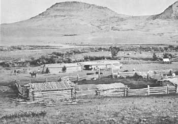 |
| Montana Territory ranch in 1872. Indicative of the primitive facilities are the chinked logs and dirt roof of the bunkhouse, which is conveniently located near the corrals. Courtesy, National Archives. |
|
FORT OWEN Montana |
|
| ||
This fort was the site of the first successful farming operations in Montana. In 1841 Father Pierre De Smet and six companions established St. Mary's Mission among the Flathead Indians. They brought oxen, wagons, carts, and plows with them from St. Louis and the following year began farming operations. By 1846 the farm had produced 7,000 bushels of wheat, 4,500 bushels of potatoes, and other vegetables. The livestock consisted of 40 head of cattle, horses, and other animals. In 1850 Maj. John Owen leased the mission property, after the missionaries had departed, and established a fort, which for a decade was the center of farming operations in the vicinity. A small portion of the fort has been restored, but most of the mission remains have disappeared. In 1956 the State of Montana founded Fort Owen State Monument.
|
HELENA Montana |
|
| ||
Helena, once the third Territorial capital of Montana and now the State capital, originated in the gold-rush days and is still an active mining town. It owes its existence to gold discoveries in Last Chance Gulch in 1864. The first miners, ex-Georgians, erected tents and crude cabins against the slopes of the gulch. A trail formed by sluice tailings on which wagons entered the camp became the main street of today's Helena. As the town grew the inhabitants changed its name from Last Chance to Helena and erected permanent buildings.
By 1870, despite a bad fire the previous year, the town was the most important in Montana. In the 1870's the discovery of rich placer deposits of gold east of the Missouri River, gold to the south and to the west, and silver and lead to the southwest spurred Helena. Silver discoveries at Wickes, Corbin, and Elkhorn in the late 1870's and the early 1880's provided even further stimulation. The city incorporated in 1881 and was reached by the Northern Pacific Railway in 1883 and the Great Northern in 1887. The richest city per capita in the United States, it was the home of 50 millionaires. The fall of silver prices in 1893, however, brought an end to a flamboyant era. Since that time the mines have passed through slumps and booms.
The brick and stone buildings along Main Street and in the southern part of town are those that replaced the flimsy structures of the early mining camp. The massive stone mansions, with landscaped grounds and carriage houses in the rear, housed millionaires during the city's heyday. The newer residential sections reflect the prosperity of modern Helena.
|
MARYSVILLE Montana |
|
| ||
This town, founded in the mid-1870's, was one of the great gold-producing centers in Montana. It had a peak population of 2,000 in 1887 and was the goal of a race between the Great Northern and Northern Pacific Railways. The most famous mine in the vicinity, the Drumlummon, produced millions of dollars in profits for its various owners, who included Thomas Cruse, an English syndicate, C. W. Merrill, and the St. Louis Mining and Milling Company. Slowly the mines in the area played out, and early in the 20th century the town lost most of its population. A number of the old buildings are still standing, including the Drumlummon Mill, frame churches, a schoolhouse, and some stone and brick buildings. Marysville is now a ski center during the winter months.
|
MILES CITY Montana |
|
| ||
Called the "cow capital" of Montana, Miles City is still in the heart of the State's range country and is an active cattle town. In the early days the south side of Main Street was a solid block of saloons, gambling dens, and dancehalls; the respectable citizens lived on the north side. An annual rodeo commemorates the historic era. Although none of the old buildings have survived, Miles City retains much of the old cowtown atmosphere.
|
N-BAR RANCH Montana |
|
| ||
One of the largest in east-central Montana, this ranch has been in continuous operation since the 1880's. In 1881 Thomas Cruse homesteaded and began ranching on Flatwillow Creek along the Musselshell River. After the catastrophic winter of 1886-87, he bought N-Bar cattle from the Niobrara Cattle Company and drove them from the Powder River to his ranch. At the end of the century he owned about 10,000 cattle and 35,000 sheep. The present ranch, undiminished in size, contains about 37,000 acres and is stocked with 1,400 cattle and 900 calves. The office, bunkhouse, and barn at the headquarters are original. The ranch is not open to the public. It is still in active operation.
|
W-BAR (PIERRE WIBAUX) RANCH SITE Montana |
|
| ||
This ranch, established on a small scale in 1883 by the wealthy Frenchman Pierre Wibaux, was later one of Montana's largest ranches. In 1884 Wibaux built his residence, the White House, near his ranch headquarters. After the disastrous winter of 1886-87, he purchased many remnants of cattle herds from cattle men who were forced to go out of business. At the peak of his operations, in the 1890's, he was one of the biggest ranchers in the United States. His 65,000 head of stock grazed a range that extended from eastern Montana into western North Dakota. When homesteaders came to the region early in the 20th century, Wibaux concluded his ranching operations and turned to mining. Today the ranch is still operated and is owned by Peter H. Scheiffer. It is not open to the public. All that remains of the Wibaux Ranch is a stone barn erected in the 1880's.
|
WICKES Montana |
|
| ||
The town of Wickes, founded in 1877, was named for George T. Wickes, a New York contractor and mining engineer who came to the vicinity with his partner, J. Corbin. The mining camps of Corbin and Wickes, 2 miles apart, were the center of an important mining area. The Alta was the largest mine, but the Gregory, the Ninah, and the Comet also provided good yields. Between 1884 and 1893 the Helena Mining and Reduction Company operated a lead-silver smelter at Wickes, the first in Montana. In 1886 the town consisted of 1,500 people and had 5 dancehalls and 22 saloons. It thrived until the end of the century, when the population left after the ores thinned out. Fires in 1900 and 1902 destroyed all the buildings. The Alta Mine, which is still being worked, has yielded $32 million worth of lead, gold, and silver.
 |
 |
http://www.cr.nps.gov/history/online_books/prospector-cowhand-sodbuster/sited6.htm
Last Updated: 22-May-2005