|
PETRIFIED FOREST
Guidebook 1941 |

|
UNITED STATES
DEPARTMENT OF THE INTERIOR
HAROLD L. ICKES, Secretary
NATIONAL PARK SERVICE
NEWTON B. DRURY, Director
A BRIEF GUIDE
TO
THE PETRIFIED FOREST NATIONAL MONUMENT
ARIZONA
West Bound — Read Down.
PAINTED DESERT RIM DRIVE Take road from U. S. 66 to rim. Distance back to 66, via rim, about 5 miles. Beautiful view of Painted Desert. Volcanic rock has formed this rim or escarpment.
PAINTED DESERT AND BLACK FOREST Formed by wind and water. Once a sesitropical jungle of coniferous trees, rushes, and ferns, inhabited by great reptiles and amphibians. River floods covered the region, with layers of mud and sand. Trees and bones absorbed minerals; turned to stone. Mountains uplifted the region; erosion washed mud and sand away; trees and bones now washing out of the hills. Erosion cutting across the many colored beds of shale and sandstone produces "the Painted Desert". Story in detail at museum.
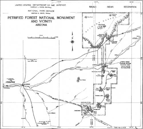
PUERCO RIVER RANGER STATION (To enter) Secure map with rules and regulations; read and follow directions; ask for information; drive carefully. Stop only at designated parking areas. (To leave monument) Sign out. Get clearance O. K. Secure information on Painted Desert and U. S. 66. While here visit Puerco River Indian Ruin back of ranger station. Short trail — 5 to 10 minutes. Ruin indicates 150 to 160 rooms. Built 800 to 900 years ago. Few rooms excavated; charred corn and beans discovered. See Indian writings on rocks below ruin (petroglyphs). Ask for information.
NEWSPAPER ROCK Side road 1/2 mile. Fine trail — 12 to 15 minutes. Remarkable prehistoric Indian writings (petroglyphs) probably 800 to 900 years old. Made by chipping through outer dark sandstone surface with sharp tool, probably petrified wood. Many interesting figures, symbolic designs, and Phallic symbols are present on these rocks, They have never been interpreted, but may be clan symbols. trail markers, or of ceremonial significance.
LOWER BLUE FOREST DRIVE Fine side road — 1/2 mile to parking area. Typical badlands exposures. Gravel trail — 1 mile long — 50 to 60 minutes. Leads to Upper Blue Forest parking area, where driver can meet any of party who walk across Blue Forest Connecting Trail described below.
BLUE FOREST CONNECTING TRAIL Gravel trail — 1 mile long — 50 to 60 minutes. Leads to Upper Blue Forest parking area, where driver can meet any of party walking across trail. Logs on 3 levels. Only forest with pink logs. Remarkable "chip" piles. Blue shale beds — typical badlands — containing numerous fossils (leaves, bones, and teeth). Standing tree stumps 1/2 mile north of trail.
UPPER BLUE FOREST SCENIC DRIVE Good graveled road. 3 miles to parking area. Fine panoramic view of Blue Forest badlands and Puerco River Valley. Conglomerate capped mesa. Pebbles in conglomerate contain Permian invertebrate fossils. Head of Blue Forest Connecting Trail.
AGATE BRIDGE TRAIL — 5 to 10 minutes. Petrified log forms natural bridge. Log 111 feet long; span about 40 feet. Erosion of sandstone, by rain water, has produced this bridge. Most noted petrified log. Log has never fallen; support only recently installed.
FIRST FOREST Fine side road — 8 to 10 minutes. Highly colored, broken logs very abundant, eroding from conglomerate bed that caps mesa. Eagle Nest Rock at end of road; peculiar erosional form. Sandstone cap; softer shale beneath. Wind and rain caused this formation.
SECOND FOREST Good trail — 20 to 25 minutes. Peculiar white, silicified logs; logs showing fire-scars; carbonized material present. Hollow logs show crystals in place. Many logs blasted years ago. Inquire at museum.
THIRD FOREST AND AGATE HOUSE Paved trail — 25 to 40 minutes. Finest long log area — some 150 to 160 feet. Panorana Knoll gives good view. Agate House side trail to prehistoric Indian dwelling recently excavated and restored; built of petrified wood; 800 to 900 years; some artifacts.
RAINBOW FOREST Start from museum on all paved trail — 15 to 20 minutes. Logs show beautiful bands of color. Old Faithful, one of the largest logs, at top of trail. Mather Memorial on side trail. Chart pebbles contain Permian invertebrate fossils.
RAINBOW FOREST MUSEUM Exhibits include beautiful polished sections of agatized wood, fossil reptiles and amphibian skulls, bones, and teeth. Charts tell story of the Petrified Forest; where the trees grew; how they were buried; how minerals in the ground turned them to stone; how mountains uplifted the region; how erosion has since uncovered logs. A diorama shows how this region appeared in Triassic time, when the forest was growing. Rare fossil fern and cycad leaves are exhibited. The particular type of fossil pine or conifer is explained. Charts show geology of region; animals and plants that lived when Forest grew; how rainbow colors formed.
U. S. 260 RANGER STATION (To enter monument) Secure map with rules and regulations. Read and follow directions. Ask for information. Drive carefully. Stop only at designated parking areas. (To leave monument) Get clearance O. K. and information on roads.
S.East Bound — Read Up.
PETRIFIED FOREST NATIONAL MONUMENT
(click on image for a PDF version)
RULES AND
REGULATIONS
(Briefed)
"IT IS UNLAWFUL TO INJURE, DESTROY, OR APPROPRIATE SPECIMENS OF PETRIFIED WOOD OF ANY SIZE WHATSOEVER, FOUND WITHIN THE MONUMENT BOUNDARY, OR TO DEFACE, INJURE, DISTURB OR MARK ANY RUINS, RELICS, PICTURES, OR OTHER WORKS OF PRIMITIVE, OR PREHISTORIC MAN, GOVERNMENT PROPERTY OR NATURAL FORMATIONS, IN ANY MANNER, AND VIOLATORS WILL BE PROSECUTED TO THE FULL EXTENT OF THE LAW, PENALTY UP TO FIVE HUNDRED DOLLARS ($500) FINE OR SIX (6) MONTHS IMPRISONMENT, OR BOTH."
At first glance it may seem that this law pertaining to the petrified weed is quite drastic, because the fragments and chips are so abundant within the monument. But it should he remembered that there are more than one hundred thousand visitors annually, and that it is most important that the reserved area be kept intact so as to be enjoyed by future generations,
"HUNTING OR SHOOTING
PROHIBITED"
"LEAVE A CLEAN CAMP"
"KEEP DOGS ON LEASH"
"TRANSPORTATION OF PASSENGERS FOR HIRE WITHIN THE MONUMENT IS PROHIBITED WITHOUT A PERMIT FROM THE NATIONAL PARK SERVICE"
READ AND OBEY THE
REGULATIONS
KEEP ON THE MAIN TRAVELED ROADS
CAMPING AND PARKING ALLOWED AT DESIGNATED AREAS ONLY
THE MONUMENT HIGHWAYS BETWEEN RAINBOW FOREST AND U.S. HIGHWAY NO. 66 ARE CLOSED DURING THE NIGHT.
FACTS ABOUT THE PETRIFIED FOREST NATIONAL MONUMENT
WHEN DID THE FOREST GROW? In Triassic time, about 160 million years ago, this region was a low-lying marshy, swampy valley. Forests of pine trees grew on the land areas and jungles of ferns, rushes, and cycads existed in the shaded and protected bogs and marshes. The principal animals inhabiting the region then were reptiles, such as the long-snouted, primitive crocodiles (Phytosaurs), and amphibians, such as the giant salamanders (Stegocephali).
HOW WAS THE FOREST BURIED? At times the streams flooded the region, and many logs and bones were buried in the sediments. Flood after flood occurred and layer after layer of differently colored muds were deposited, until the forest was buried to a depth of some 3,000 feet. Later still the area subsided and was covered by a shallow sea.
HOW DID THE TREES TURN TO STONE? The processes by which the trees were changed into stone are not thoroughly understood. The plant tissues are removed and their form is preserved by physical or chemical replacement processes. The replacement mineral is chiefly silicon dioxide (quartz), most of which is obtained from ground water. This petrifaction usually takes place after the plant has been buried in the mud.
HOW WAS THE FOREST BROUGHT TO LIGHT? Since the time when the forest was buried there have been several periods of great mountain making. Forces from deep in the earth have thrust the Rockies and Sierra upward several thousand feet, with the result that the land between these ranges was lifted far above its former position near sea level. As a result of this great mountain growth, certain areas became arid and desertlike, and soon the forces of erosion — wind and rain — started tearing down the great deposits that covered this region. Large river systems reestablished, which, with their many tributaries, carried away the loose mud, sand, and gravel, which finally found its way to the sea. Thus the sediments that once covered the forest were removed, and finally the layers in which the logs were buried were cut by canyons and ravines, revealing the great petrified logs and the many bands of colored rock that make up the Painted Desert. As the logs wash from the hillsides, they break into sections which accumulate in piles at the base of the cliffs. At the present time only a small portion of the forests once buried and petrified is exposed, for the logs occur below the surface of the ground at a depth of about 300 feet. Here they await their turn to be excavated and become objects of awe and of admiration.
WHEN DID PREHISTORIC MAN USE THE PETRIFIED FOREST? A thousand years ago, prehistoric man flaked beautiful arrow points from the chips of petrified wood, and about 800 to 900 years ago prehistoric man gathered up the broken blocks of petrified wood and used them as bricks to build his home. Several "Agate" house Indian ruins have been discovered in the Petrified Forest, and one in the Third Forest has been excavated and partly restored. It is also believed that hammers and chisels of petrified wood were used to "peck out" the prehistoric pictures and writings that are seen on many of the sandstone cliffs in this region.
WHEN DID MODERN MAN TRY TO USE THE PETRIFIED WOOD? About 1851 and 1853, white men first called attention to the petrified forests. No attempt was made to use the petrified wood then, but in the 80's and 90's eastern interests case in and blasted many of the logs to secure the amethyst crystals which were sometimes found in the hollow centers. One company attempted to crush the petrified wood into an abrasive material, while others discovered that the petrified wood could be polished, thereby making more vivid its many colors.
WHY DID THE GOVERNMENT SET ASIDE THE PETRIFIED FOREST NATIONAL MONUMENT? Because the petrified forest (of such great scientific value) was being exploited by private interests, the President, in 1906, set aside the area to he known as the Petrified Forest National Monument. The area remained undeveloped for many years, and considerable vandalism occurred. Some time later the National Park Service assigned rangers to the area for the enforcement of the laws.
HOW HAS THE PETRIFIED FOREST NATIONAL MONUMENT BEEN DEVELOPED FOR THE PUBLIC? Fine paved roads cross the monument and short foot trails make accessible the beauties of the different forest areas and Painted Desert. Rangers and naturalists are at stations to enforce the laws, assist in directing the visitor, and to explain in simple language the story of the Petrified Forest and Painted Desert. Museums display beautiful polished sections of petrified wood. These specimens have been carefully ground with carborundum dust, a fine abrasive. The agatized wood is very hard, and a piece of any size requires long and careful grinding. The story of the petrified wood is told in the museum by wall charts, dioramas, and specimens of fossils and rocks.
WHAT HAS SCIENCE LEARNED FROM THE PETRIFIED FOREST? Scientists first were interested in the type of tree represented by the fossil logs, which were soon identified as very primitive conifers or pine trees, called Araucarian Pines, a type of tree that became extinct in North America millions of years ago. Bones, teeth, and skulls of prehistoric animals were found which led to the identification of Phytosaurs, Stegocephalians, Anomodonts, and Lung-fishes, all of which were highly specialized forms of ancient reptiles, amphibians, and fishes. Very recent discoveries of beds of fossil leaf impressions indicate that ferns, cycads, and neocalamites were abundant in the shaded and protected areas. The plant life of the Triassic in western North America was practically unknown until these discoveries, and future studies will add greatly to our knowledge of the trend of plant development which made rapid and important adjustments in this particular geological epoch. From the studies of animal and plant remains the geologist has been able to determine that these deposits accumulated later than those of the great coal-forming period (Carboniferous) and earlier than the time when the dinosaurs reached their greatest development (Jurassic and Cretaceous epochs).
September 1941
| <<< Previous | <<< Contents>>> |
guidebook_1941/sec7.htm
Last Updated: 14-Aug-2009