|
PALO ALTO BATTLEFIELD
A Thunder of Cannon Archeology of the Mexican-American War Battlefield of Palo Alto |

|
CHAPTER FIVE
DOCUMENTARY ANALYSES
A simple 1:1 overlay of period battle maps of Palo Alto onto USGS topographic maps and aerial photographs does not provide a reliable reconstruction of the battle lines. The standards and scaling of period maps were not at all accurate as compared with USGS quadrangle maps of today, nor were period maps expected to be that accurate. This situation prevents precise correlation of Palo Alto battle maps with modern maps of the battlefield. Reasonably accurate battle interpretation requires synthesis of selected and weighted information obtained from various historical maps and battle accounts. Only then can such data be correlated in conjunction with topographic maps, aerial photographs and artifact distributions.
Historic maps and eyewitness accounts of the battle are subjective constructs of their authors, whose observations possibly were influenced by nationalistic biases or faulty powers of observation. Some eyewitness accounts of the battle of Palo Alto disagree on specifics, perhaps due to confused memories when written many years later. Recorded observations of battle events might conflict due to various fields of vision, the latter probably obscured, at times, by the literal "smoke of battle". Soldiers often recollect a battle as "a half-remembered blur, a mosaic somehow fragmented and haphazardly reassembled" (Keegan and Holmes 1986:263).
Mexican-American War historian Justin Smith noted a large number of both intentional and accidental misrepresentations existed in official military documents of the war:
It was legitimate for a general, bearing in mind that probably his statements would soon become known, to consider their effect on the officers concerned, the army in general, the government, the public at home, the enemy, and the world at large...To gain these ends more or less misrepresentation was needed...General Taylor received great credit for his reports, but they were written, in fact, by the assistant adjutant-general of his army, W.W.S. Bliss, who was a finished artist in discreetly [sic] omitting and sagaciously emphasizing. Bliss never lied and never told the truth, one may almost say (Smith 1915:96-97).
Yet objective battlefield data, such as aerial photographs, topographic maps and archeological evidence, have their interpretive limitations as well. As noted in Chapter Two, various alterations in topographic and vegetative configurations have occurred at Palo Alto. Some alterations are obviously manmade, or are known as such through informants, others are the result of natural erosion and deposition that have been ongoing since the battle. Thus, one cannot presume every natural feature described at the time of battle has the same configuration today or, for that matter, still exists. For example, one could mistakenly assign historical significance to a present-day marshy area not in existence at the time of battle. Furthermore, the "true" marshy area may have long since dried up or filled in without leaving any visual trace.
Assigning artifact concentrations to a specific battle event, such as a historically documented Mexican flanking maneuver, has its interpretive hazard as well. Battlefield plundering by relic collectors has compromised pattern interpretation to an unknown degree since artifacts have been both selectively and intensively removed from accessible areas. Possibly a seeming artifact cluster, demarcated by an area bare of artifacts, owes its anomalous existence not to a specific battle event but rather to a protective vegetation covering (protective, that is, until the archeologist removed it), the bare area surrounding this patch of thick vegetation cover long since stripped of its artifacts.
Greater weight attends to battlefield data that holds up best under the following four criteria:
Closeness. Sources of information from actual observers and participants of the battle. Fortunately, there are a number of such sources. There also are sources who provide hearsay accounts, or accounts recorded many years after the battle took place.
Competence. Of the above sources, those most capable of understanding and describing the battle. The best detailed descriptions of battle events were done by educated individuals, making exacting reports of their observations.
Mutual Support. Eyewitness sources that give congruent descriptions of specific battle events and topographic features that strongly support their validity. This is especially true if the sources were opponents since there is much less chance of one such informant influencing the other.
Impartiality. The sources with the least to gain from distortion of battle events, for example, a soldier whose career would not be enhanced or jeopardized by providing a true account of what he observed. In a sense, this criterium also includes archeological data. Such data provides artifact patterns that are a dispassionate record of battle events; the interpretor of that record is the one who may lack impartiality.
Thus, the ideal sources of evidence would be highly competent and impartial observers whose written observations are mutually supportive. Realizing such sources for Palo Alto research is, unfortunately, comparable to Diogenes' search for the Honest Man.
Historic Maps
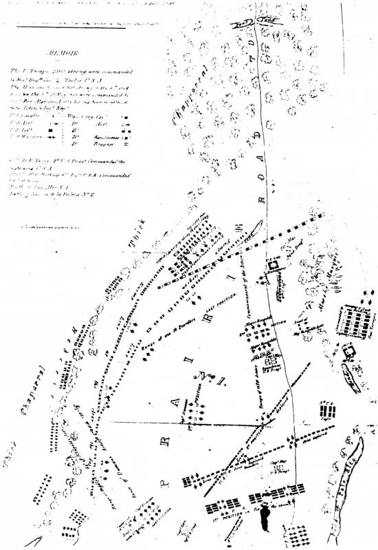
Historical interpretations of Palo Alto greatly depend on period maps illustrating military units placement and their various tactical maneuvers. Of equal importance are the topographic data such documents provide. Unfortunately, for whatever reason, U.S. Topographic Engineers on Taylor's staff did not prepare official battle maps of Palo Alto and Resaca de la Palma as they did for all of the rest of the major battles south of the Rio Grande. Several contemporary U.S. battle maps of Palo Alto were produced by unknown or obscure individuals, for example, the unsigned Palo Alto map by Henry (1847:92) and Stewart (1887), who may well have used superannuated, nonauthoritative battle accounts to produce the maps.
A somewhat different problem exists vis-a-vis the battle map of Palo Alto prepared by an officer of the Mexican army. In this instance, two semi-official battle map sketches (Figures 26 and 27) were produced by General Mejía's adjutant, Captain Jean Louis Berlandier. Berlandier, a noted nineteenth century French geographer, produced writings, drawings and maps of northern Mexico that have been of great use to later scholars; he meets both criteria of closeness to the event and educated competence. However, as discussed below, the Berlandier sketches are not without their own peculiar problems.

|
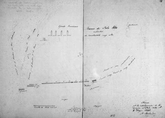
| Figure 26. Berlandier's first sketch of the battle. |
|
| Figure 27. Berlandier's second sketch of the battle. |
The Berlandier Sketches
Primary research conducted by NPS historians resulted in the discovery of Berlandier's two sketch plans of the battle, drawn shortly after the battle took place. Presumably Figure 26 is Berlandier's first sketch attempt since its page number is 55; the second sketch, Figure 27, is paginated 78.
Essential battle data noted on both sketches include: 1) the initial position of the Mexican army between the Matamoros Road and the western terminus of the low rises to the east; 2) orders of battle for both armies during both phases of the battle; 3) the various maneuvers of both armies; 4) approximate spacing between the two opposing armies; 5) location of the road to Matamoros; and 6) the general locations of resacas, ponds, low rises and mesquite thickets.
Berlandier noted on his first sketch the presence of two or three marshy areas, centered more or less between the two opposing forces. He apparently then decided to group them together on the sketch as simply one large marsh. In addition to this marsh he delineated another, smaller marshy area, located directly in front of his placement of Captain Duncan's battery during the final phase of battle. Both of these marshes are present on the second sketch, but their delineations are faint, as if they had been erased.
The earliest known published battle map of Palo Alto appeared in Compaña Contra los Americanos, Mayo de 1846 (Anon. 1846b:10) (Figure 28), published a few months after the battle. Hereafter, this battle map is referred to as "Map A". Berlandier was the author of Map A, his sketches unboubtedly used to provide the information described on this map. Map A was a significant source of information for several historians who wrote about the battle. For example, it was republished in The Other Side: Notes for the History of the War Between Mexico and the United States (Alcaraz et al. 1848), a Mexican account of the then recently concluded hostilities. The U.S. translation of this book (Ramsey 1850) (Figure 29) also used Map A; and an 1887 map of the battle, by a J.W. Stewart, an unidentified cartographer, used Map A. Stewart, however, made a significant revision of Mexican troop movements during the second phase of battle (Figure 30). Hereafter, Stewart's edited version, combining elements of Map A and Ramsey's map, is referred to as "Map D".

|
| Figure 28. Mexican battle map (Map A) (1846). |
|
| Figure 29. Ramsey's map (1850). |
|
| Figure 30. Stewart's map (Map D) (1887). |
Unlike Berlandier's first sketch showing one large marsh between the two armies, Ramsey's map shows five marshy bodies widely scattered between the two armies. These marshy areas are described as "low bottoms" on the map legend. Also, Mexican troop movements noted on Map A show these low bottoms hindered the advance of the Mexican right flank during the final phase of battle. Apparently, a marshy obstruction of some tactical significance existed between the two armies. This obstruction was perhaps one reason why significant troop movements at Palo Alto occurred only on the flanks. Any major assault toward the center of the opposing army might have literally bogged down, inviting destruction of the stalled attackers.
Map A and Berlandier's sketches show the relatively high ground that demarcated the southern and eastern boundaries of the battlefield. The second sketch presents the most detailed information regarding the high ground, described as "lomas muy baxas y muy tendidas" ("hills that are very low and very spread out"). This formation probably was the low levee still bordering the present-day resaca located in this area of the battlefield (Area G, Figure 3). Fronting the northern sides of this probable levee were "baños un poco pantandos" ("a few stagnant ponds").
Berlandier also identified a resaca at the southern end of the dune series, as well as motitas ("low rises"), situated directly behind the extreme right flank of the Mexican army. Berlandier's sketches and Map A show thick vegetation cover south of the Mexican position, and the approximate locations of the Mexican field hospital and wagon park.
Curiously, on his second sketch (Figure 27), Berlandier lightly drew in a large detachment of Mexican cavalry and light infantry at the northern end of the above-described dunal formation—almost a mile away from the Mexican right flank. Neither his first sketch nor Map A illustrated such a phantom and forlorn detachment, which raises some doubt as to its actual placement, or possibly even its existence, on the battlefield. Yet this isolated Mexican detachment also appears on Captain Henry's map of Palo Alto, that is, "Map B" (Figure 31), discussed below.
|
| Figure 31. Henry's map (Map B) (1847). |
On his first sketch Berlandier detailed the battle positions held by the various U.S. battalions and batteries toward the end of the day (Figure 26). Yet Map A illustrates these U.S. positions in a different battle line configuration. Noteworthy is that Berlandier's first sketch best approximates what American officer Lieutenant Scarritt observed and sketched for the final phase of the U.S. battle line.
Taken as a whole, Berlandier's two sketches, Map A and Ramsey's version of Map A portray a Mexican army that: 1) adopted an initial defense strategy not especially innovative in concept but appropriate in basic principles for line battle tactics, that is, anchoring both flanks on topographic obstacles to discourage enemy outflanking attempts, and cavalry units stationed on the flanks; 2) conducted several aggressive cavalry and light infantry attacks on both flanks of the enemy, including a final, 35° counterclockwise swing northwestward of the entire Mexican line; and 3) held at bay the U.S. army, the latter shown as never coming to within about 150 yd of the Mexican left flank. If this were true it means the Mexican army did not retreat from their strategic position on the Matamoros Road.
The American Maps
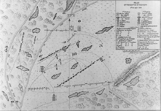
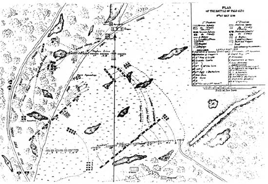
The three following published battle maps conflict with certain details on Berlandier's sketches: the map presented by Captain W.S. Henry in his Campaign Sketches of the War With Mexico, published in 1847 (Map B, Figure 31); and the battle map (Map C, Figure 32) drawn by Lieutenant S.D. Dobbins of the Third Infantry and published in a pamphlet a few months after the battle of Palo Alto (Anon. 1846a). This map also was reproduced with minor changes in Brooks (1965 [1849]:126), and by J.W. Stewart in 1887 (Map D, Figure 29) and in Wilcox (1892:52).
|
| Figure 32. Dobbins' map (Map C) (1846). |
Captain Henry was not at the battle of Palo Alto but joined Taylor's command some months later. In his book, Henry stated he depended on official dispatches and personal written accounts to describe events at which he was not present, for example, the battle of Palo Alto (Henry 1847:v). Lieutenant Dobbins was an officer with the Third Infantry, the regiment at Palo Alto that moved to the American right (west) flank in defense of the wagon train. From this position Dobbins probably would not have been an actual observer of the battle activities east of the Matamoros Road. Thus, to produce his map, Dobbins would have had to obtain much of his information from official documents and other knowledgeable battle participants. Stewart's 1887 Map D was acquired from the Brownsville Historical Association as a nonreferenced document; since it appears in Wilcox (1892), Map D may have been created specifically for that book.
Instead of a Mexican advance pivoting on their Fourth Line regiment, both Maps B and C show a retreat of the Mexican left flank while only their right flank advanced. These American maps, however, show the Mexican center as their pivot point during the second phase of battle. Also, Maps B and C show the final Mexican battle line as extending along an almost north-south axis, which represents more than a 75° shift from its original position. In contrast, both Berlandier's sketches and Map A show a Mexican line shift in a counterclockwise direction of about 35° Maps B and C also portray the retreat of the Mexican left flank as an abandonment of their initial position on the Matamoros Road; this is a significant contradiction to Map A, Ramsey's map and Berlandier's sketches.
Maps B and C, unlike the Mexican map and sketch versions, identify the presence of Mexican reserves behind a belt of thick vegetation, presumably the higher ground illustrated on both of Berlandier's sketches and on Map A, and provide greater detail on the various positions taken by the American light field pieces. Interestingly, Map B shows the Mexican irregular or "ranchero" cavalry on the Mexican right flank; in all written accounts, the Mexican irregular mounted unit, led by General Canales, was positioned well to the west of Palo Alto and did not participate in the battle.
Map B identifies a marshy area between the initial battle lines, as do Bandelier's sketches and Map A. However, Map B shows the U.S. second battle line position partially within this marshy area, suggestive that the latter may not have been an especially significant tactical obstacle (Figure 30; note that the orientation for Map B has "South" at the top of the page and no scale).
Map B shows the U.S. supply train approximately equidistant between Palo Alto pond and the initial position of the U.S. army. This map version also shows the train formed in a defensive, compacted formation by the time the battle began. In contrast, Berlandier's sketches and Map A depict the train as an unformed, essentially defenseless string of wagons. Ramsey's map, however, shows the wagons in their post-battle defensive position, that is, just south of Palo Alto pond and in defensive formation.
Map C shows U.S. and Mexican positions in three phases: 1) their initial battle lines; 2) a later counterclockwise shift in linear positions; and 3) a final phase, in which U.S. 18-pounders faced almost due east. During the final phase, the Mexican line is shown extended along an almost north-south axis in front of a belt of chaparral on the eastern limits of the battlefield; presumably, the chaparral corresponds with the "very low hills in a series" noted on Berlandier's sketches and on Ramsey's map. Map C also shows the last location of Duncan's artillery pieces; at this point, the distance of his pieces from the Mexican line is 200 yd.
Finally, Stewart's 1887 Map D (Figure 29) shows the retreat of the Mexican army from their defensive position on the road, which is suggestive that Map D was largely based on information gleaned from the earlier Maps B and C.
Lieutenant Scarritt's Sketches
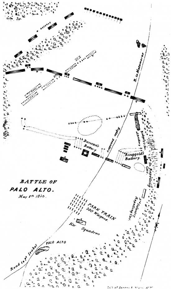
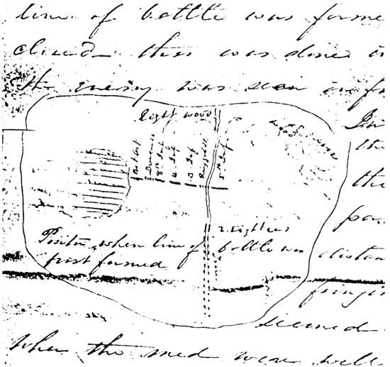
Lieutenant J.M. Scarritt was the officer in charge of the fortified wagon train the day after the battle. Four days later, Scarritt wrote a letter to a Colonel J.G. Totten in which he described the battle (Scarritt 1846). In the margins of his letter Scarritt provided three sketches showing the battle phases and various unit maneuvers conducted by both armies (Figures 33-35); a fourth sketch shows a plan view of the defensive earthworks for the wagon train (Figure 15). None of the sketches include a scale or north arrow. Figure 33 is Scarritt's first sketch, showing the "[U.S.] position when line of battle was first formed" (Scarritt 1846). According to the text of the letter, this line of battle was formed:
...when about 15 miles from Point Isabel and one mile this side of the position called Worth's Camp...this was done in consequence of the report of our advance that the enemy was seen in front and appeared to be advancing...The force advanced until it came to the water hole at Gen. Worth's camp...From this position the enemy were distinctly seen distant about two miles... (Scarritt 1846).
|
| Figure 33. Lieutenant Scarritt's first sketch, initial order of battle of the U.S. army. |
Besides labeling the various U.S. units, Scarritt also noted on the first sketch: 1) a broad, marshy area to the immediate left (east) of the Artillery Battalion, the latter positioned on the extreme left flank of the U.S. army; 2) Matamoros road, as well as the wagon train strung out on the road and behind the army; and 3) "light wood" and "wood resace" [sic] to the north and west of the army, respectively.
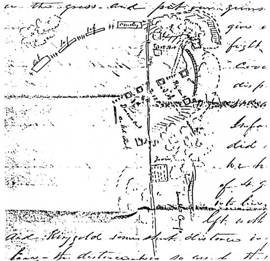
Figure 34 is Scarritt's second sketch, which shows both armies' unit positions at commencement of the battle. Although no attendant scale, the text of the letter states the U.S. right flank "came within one half mile of [the Mexican] left". The sketch also shows: 1) the U.S. train had, by then, assumed its defensive formation and position at "Worth's Camp", a clearing between the road and Palo Alto pond that had been occupied by the Mexican army just a few days before the battle; 2) the Mexican battle line extending across the prairie in a broad arc formation, with a total of 10 cannon interspersed between the Mexican units; and 3) the Mexicans' initial flanking attempt, a maneuver thwarted by the U.S. right flank.
|
| Figure 34. Lieutenant Scarritt's second sketch, first phase of the battle. |
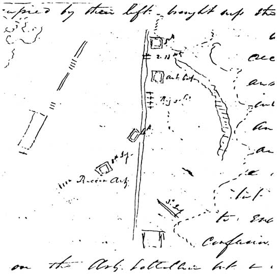
Figure 35 is Scarritt's illustration of the final phase of battle. It shows: 1) the right flank of the U.S. army more or less aligned with the road and "advanced...to the place [once] occupied by [the Mexican] left..."; 2) Churchill's 18-pounders and Ringgold's 6-pounders, both batteries aligned perpendicular to the road to face the final Mexican battle line now positioned to their east; and 3) Duncan's battery in its final position to enfilade the oncoming Mexican right flank.
|
| Figure 35. Lieutenant Scarritt's third sketch, final phase of battle. |
In summary, Scarritt's sketches, Henry's Map B and Dobbins' Map C are in agreement that: 1) the Mexican line extended along an almost north-south axis during the final phase of battle, presumably as a defensive reaction to the final U.S. position situated in part on the original Mexican battle line and in rough alignment with the Matamoros road; and 2) as a result of this new position, the Americans forced back the Mexican left flank. Thus, the illustrations of Scarritt, Henry and Dobbins meet the criterion of mutual support. Stewart's Map D seems to be a hybrid of earlier published maps, representing both Mexican and U.S. versions of the battle.
But what of Berlandier's sketches, Map A and Ramsey's version of Map A? These maps show the Mexicans accomplished an orderly, almost clockwork precision pivot advance toward the Americans, an interpretation sharply at odds with the above-described contemporary U.S. maps and sketches. Yet we consider Berlandier to be part of the select group of competent eyewitnesses; in fact, some of his sketch notations receive mutual support from certain U.S. map versions, such as the marshy area between the battle lines, orders of battle, and various other maneuverings of both armies.
At this juncture, one must consider the possibly overriding criterion of impartiality, or lack thereof. Perhaps it was politically wise for Berlandier to illustrate an aggressive Mexican advance of their entire battle line during the final phase of battle instead of a collapse of their right flank, which is what happened. Smith's earlier quoted assertion regarding official U.S. Army equivocations during the war applies to officers of the Mexican Army as well. It is also possible Berlandier's tactical observations were simply the result of an honest mistake; he, too, must have experienced some obfuscation and confusion resulting from the "smoke of battle". One can never ascertain the underlying psychological motives that directed any of the participants, including Berlandier, nor do we desire to impugn the integrity or competence of those who can no longer defend their actions. However, one can evaluate and compare the ultimately subjective qualities of battle maps and eyewitness accounts with aerial photographs, conjoined with the patterned material results of the battle.
Aerial Photographs
Fortunately, Palo Alto battlefield has largely escaped the extensive agricultural alterations occurring throughout the Lower Rio Grande Valley. In addition to artifact protection, such relatively pristine topographic conditions permit identification of several historically described topographic and cultural manifestations on the battlefield. These features include: 1) Palo Alto pond; 2) a segment of the Matamoros-Point Isabel Road where the Mexican left flank bisected it; 3) the resaca that figured prominently on the west side of the battle; 4) the Tanques del Ramireño Road; 5) the low rises or motitas anchoring the Mexican right flank; 6) the marshy area between the battle lines; and 7) the approximate location of the lomas ??tendidas or resaca levee noted on Berlandier's sketches. Refer to Figure 3, the battlefield aerial photograph, for the following discussion of these features.
Palo Alto Pond (Area A)
Although presently drained by a stock tank, Palo Alto pond nevertheless is visually prominent on the aerial photograph. Several battlefield accounts note the U.S. army obtained water from this pond, located just west of the wagon road they followed, before their final advance toward the Mexican army (e.g., Taylor 1846; Scarritt 1846). Also, the southeastern portion of the pond was the approximate location of "Worth's Camp", where the U.S. wagon train formed into defensive position. Recognition of Palo Alto pond permits an educated guess regarding the initial battle line location of the U.S. army (Figure 10). Also, various defensive maneuverings of the U.S. Third, Fifth and Eighth Infantry regiments were conducted to the east and west of this pond, for wagon train protection; therefore, approximate locations of these regiments during this phase of battle can be deduced.
Matamoros/Point Isabel Road Segment (Area B)
This feature appears on the aerial photograph as an anomalous linear configuration typical of abandoned roads. A ground check revealed this is an area of disturbance vegetation extending within the park boundary for some .4 mi and averaging around 50 ft wide. Close inspection of the aerial photograph also shows a fork in the now-abandoned road. This probably is the same road fork illustrated on Berlandier's sketches (Figures 26 and 27). If correct, then the cavalry and light infantry units that comprised the left wing of the Mexican army initially were stationed just to the north of the fork and, to their left, "woods and marshes difficult to overcome [by the enemy]" (Berlandier 1846:161), that is, the resaca labeled Area C. Following this line of reasoning, the Mexican Fourth Line Regiment took its initial position some 400 yd to the east of the road fork, with Torrejón's?? cavalry units stationed to the immediate east and west of the fork. During the final phase of battle, Churchill's 18-pounder battery would have been positioned on this road approximately where the Mexican left flank initially was stationed, that is, near the road fork. Also in this vicinity were the Artillery Battalion, the Fourth Infantry and May's Dragoons (Figure 14).
The Resaca (Area C)
A number of battle accounts (e.g. Taylor 1846; Scarritt 1846; Anon. 1850) emphasize the tactical significance of a resaca where it bordered the west side of the above-mentioned wagon road. These "woods and marshes difficult to overcome" anchored the Mexican left flank. Undoubtedly this is Area C. Probably within Area C, bounded on three sides by a loop of this resaca, Torrejón carried out his flanking attempts. Likewise probably within this area the U.S. Third and Fifth Infantry regiments, Ringgold's battery and Texan volunteers took their defensive positions to force the Mexicans back (Figure 13).
Tanques del Ramireño Road (Area D)
This dirt road probably is an actual segment of the old Tanques del Ramireño Road, the route taken by the Mexican army when they first entered the battlefield. A ground check revealed this is still the most practical route when one approaches the open prairie of Palo Alto from this direction; a more linear, direct approach is impractical due to two resacas, both visible on the aerial photograph. These resacas cause the road to loop well to the east.
Motitas (Area E)
Given the fact there are no other low rises in this area of the battlefield, undoubtedly Berlandier's motitas are these same two low rises identified as Area E. One of these low rises was described by the Mexicans as "the hill of Motisas" (Berlandier 1846:9; In Sanchez 1985:15). Local tradition refer to these two low hills as las motitas de Arista or "Arista's Hills", in the belief General Arista placed his field headquarters here (Walter Plitt, personal communication 1992). Regardless of where Arista pitched his tent, the motitas provided a natural albeit meager anchor for the Mexican right flank. Also, the Mexican provision wagons were placed behind "the hill of Motisas" to exploit its relative protection (Anon. 1846c:9; In Sanchez 1985:15).
A line running east-west between Area E and the road fork of Area B should then represent the approximate location and axis of the initial Mexican battle line (Figure 10). The distance between these two defined areas is a little less than a mile. Mexican records noted their battle line consisted of 3,300 men (it is not clear if this included cavalry units) "...two men deep, without secondary lines, nor reserves, nor any concentration of troops whatsoever" (Berlandier 1846; In Sanchez 1980:12). Two lines of men, each line thus consisting of some 1,650 men with each man allotted "two paces" (five feet) of linear space, the regulation spacing between Mexican soldiers (Orga 1808:128; Anon. 1846c; Hefter et al. 1958:51), would have resulted in a battle line 1.5 mi long. Additional space for artillery pieces between the units would have extended the line a bit further, and Mexican cavalry on the flanks would have extended the Mexican battle line even more.
Marshy Area (Area F)
As previously noted, Berlandier's sketches, Ramsey's map and Maps A and B show the existence of a broad marshy feature between the two battle lines. The only candidate for this topographic feature is Area F. A ground check of Area F revealed a predominance of water-loving plants within its confines; there is a drainage stock located more or less toward the center of this feature. Presumably if the stock tank were removed, this seemingly innocuous portion of the battlefield would soon revert to its pristine, bog-like characteristics. If Area F was avoided by both sides as a tactical hazard, then Mexican-related artifacts, mixed with U.S. ordnance, should lie to the south and east of this feature; conversely, U.S-related artifacts and Mexican ordnance should lie north and west.
Lomas Tendidas (Area G)
Area G is notable in that it seemingly does not exist as a topographic feature today. A ground check showed this area to be typical Palo Alto prairie with virtually no relief. Nevertheless, some sort of linear natural feature once existed in this area since three battle maps indicate it: Berlandier's sketches, Henry's Map B and Dobbins' Map C. These maps show it as a belt of "thick chaparral". Biologist Norman Richard (personal communication 1993) believes the soil found on this area of the battlefield, in fact, would have supported such a vegetation cover.
Area G probably was the low levee that still borders the resaca east of the motitas. This levee, in 1846, may have supported brushy vegetation because it was significantly higher in elevation at that time. Even today, Area G becomes more apparent when heavy rains inundate the lower elevation lands surrounding the old levee. This may have been the situation the day of the battle.
The above hypothetical conclusions are not offered as "truth" or "fact". They are simply possible explanations, open to continued testing and revision upon the discovery of new facts. Investigation, therefore, is required of both documentary and nondocumentary data, that is, data tied to the field environment where the battle took place. This is the realm of archeological investigation, discussed in the following chapters.
| <<< Previous | <<< Contents>>> | Next >>> |
paal/thunder-cannon/chap5.htm
Last Updated: 25-Feb-2009