|
PALO ALTO BATTLEFIELD
A Thunder of Cannon Archeology of the Mexican-American War Battlefield of Palo Alto |

|
CHAPTER TWO
ENVIRONMENT
This chapter is a synopsis of two independently directed environmental studies of Palo Alto battlefield, both surveys conducted in 1992-1993. Mike Farmer (1992) of the National Audubon Society, and Norman Richard and Dr. Alfred Richardson (1993), the latter two of the Biology Department, University of Texas at Brownsville, performed these surveys. Together, the surveys focused on: 1) developing faunal and floral inventories, including identification of endangered and threatened species; 2) mapping vegetational associations; 3) assessing manmade impacts on the battlefield; and 4) extrapolating the location of topographic manmade features significant to the conduct of the battle, and the battlefield landscape as it may have appeared in 1846. A comprehensive listing of battlefield fauna and flora are available in the above two reports.
General Ecology
Palo Alto battlefield is on the southern tip of Texas, within the Lower Rio Grande Valley (LRGV). The LRGV is not a true valley but rather a flat delta of the Rio Grande. The Gulf of Mexico is 20 mi to the east of the battlefield and the U.S/Mexico boundary, the Rio Grande approximately 9 mi to the south. The area surrounding the battlefield is a flat, featureless plain, with elevations ranging from about 8 ft to just over 20 ft above sea level (Brown et al. 1980) (Figure 3, pocket insert).
The LRGV is semiarid and subtropical. Annual precipitation is about 25 inches at Brownsville; however, rainfall in the area has been described as both seasonally and annually erratic. Most rainfall occurs in August, September and October. The driest months are March and April. Temperatures range from an average low of 48° F in January to an average high of 97° F in July. Winds are from the southeast from March through November, with short-lived but strong northerly winds from December through February. These year-round winds often contribute to an overall dry climate and periods of significant droughts.
The Rio Grande has been the dominant active force in extreme south Texas since the Pleistocene. Approximately 30,000 years ago, the sea level began to drop, resulting in the eventual formation of a broad, deep valley. Beginning 18,000 years ago, when the sea level started to rise, the valley began to fill with both deltaic and estuarine deposits. During the last several thousand years, the LRGV became generally inactive due to a drier climate. Only hurricanes tend to break the cycle and bring in new soil deposits. As a result, the geology of the region consists of relict or periodically active environments.
Sediments beneath the battlefield are Holocene and Modern fluvial-deltaic. Holocene and Modern deposits are characterized by broad flood basins between inactive meander belts and distributary channels abandoned by the Rio Grande. These belts and channels are prominent features of the battlefield. Such features not filled by erosion locally are termed resacas rather than "oxbow lakes", the term commonly used for this feature in other regions of the United States (Brown et al. 1980). (The word resaca derives from the Spanish word resacar, meaning "to take back"). The resacas of Palo Alto battlefield are best described as intermittent or remnant. They are not maintained by any political entity such as a drainage or irrigation district. Such seasonal wetlands can be valuable for wildlife during times of rainfall and runoff. At regular intervals along much of their length, wetland obligate plants such as sedges and cattails are evident (Martin and Hehnke 1981:19-46).
Soils of Palo Alto
Palo Alto soils either are clay or clay loam. All of the soils are saline, with generally poor drainage formed on remnant flood basins between resacas. The relative impermeability of these soils, combined with naturally poor drainage, has resulted in periodic flooding. The resacas are generally of the same soil types as are the surrounding flood basin. Soils created on resaca flood plains primarily are over-bank silts and clays, and many river-created landforms on the battlefield are still evident. Erosion and agricultural land preparation obscure the undercut banks formed on the outside of meander beds and the point bars created on the inside curve of resacas. Resacas may be abandoned during periods of flooding, when the river cuts through a slough of a point bar or across the ends of a resaca, the ends commonly plugged with sediments. Eventually, erosion creates a meander scar in the landscape by filling in the old resaca bed. Palo Alto battlefield displays many such features attributed to the meanderings of the Rio Grande.
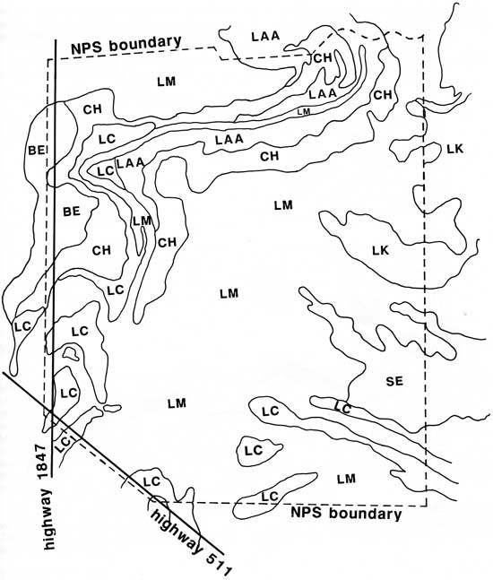
Battlefield soils, as labeled by the USDA Soil Conservation Service (Williams et al. 1977), are as follows (Figure 4):
Salt Prairie Soils
Benito Clay (BE); Lomalta Clay (LM); Latina Sandy Clay Loam (LK); and Sejita Clay Loam (SE). These are saline soils that dominate open, flat salt prairie. Very little woody vegetation can be supported by it. Runoff is slow or nonexistent due to level or even concave surfaces, the latter filling with water after heavy rainfall. In addition, hurricanes can push tidal waters onto the battlefield. The resacas are generally the same soil types as in the surrounding flood basin, and likewise hold water well and for some time after heavy storms.
Levee Soils
Laredo Silty Clay Loam (LAA). These sandier soils make up the low levees immediately adjacent to the resacas. They have moderate permeability and slow runoff. Slopes are generally low but can be convex. The levees are slightly higher than the surrounding Prairie soils (e.g., Area G, Figure 3). As a result, they drain better and have correspondingly less salinity, allowing for native brush vegetation to occur here.
Transition Soils
Chargo Silty Clay (CH); Laredo Silty Clay Loam, saline (LC). These soils are also deposited adjacent to resacas. They are slightly higher than the Salt Prairie soils and, as a result, Transition Soils have a small slope or are convex. This allows for some runoff and leaching of salts down to the prairie. Some areas of these soils are high and drained enough to support dense brushland.
|
| Figure 4. Soil map of Palo Alto Battlefield NHS, showing the Salt Prairie soils (LM, LK, BE, SE), Levee Soil (LAA), and Transitional soils (CH, LC). |
In some locations on the battlefield, the elimination of native vegetation, with its attendant erosion of higher soils onto the resacas, has begun obscuring the transition between the saline basins and the old resacas. Transitional soils, particularly type LC on the battlefield, can be indistinguishable, either by elevation or vegetation structure, from adjacent salt prairie. One landowner stated clearing for crops on some of his best land resulted in the filling of a resaca segment with an additional 4 ft of erosion material (Farmer 1992:5).
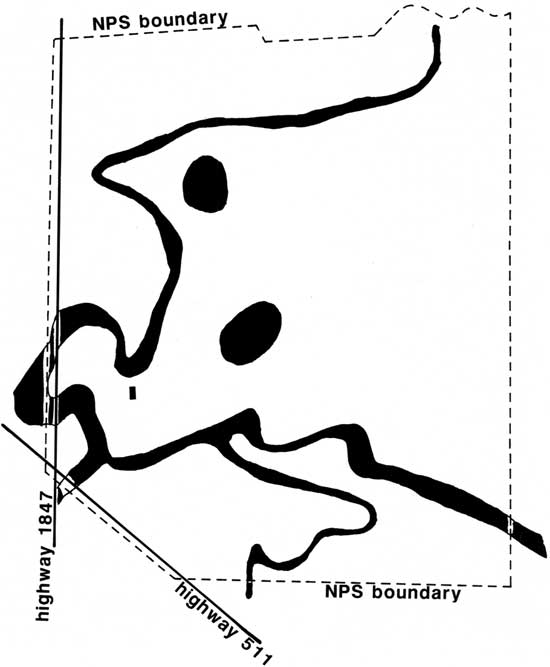
Wetlands
Wetlands consist of small, shallow segments of old resaca beds that retain water much of the year (Figure 5). For example, just before the heavy rains in June, 1993, most of these beds were dry and covered with grasses and a few shrubs. After the rains, much of the beds were covered with water. Several scattered cattle tanks are dug into old resaca beds, where natural drainage brings in water. Irrigation keeps water in some of the tanks during the absence of rain. Spoil dirt is piled on each side of the tanks, providing a habitat for mesquite and other Tamaulipan Brushland plants.
|
| Figure 5. The major wetlands of Palo Alto Battlefield NHS, consisting of Resaca de Palo Alto, Palo Alto Pond, old meander beds, and excavated ponds. |
Based on a 1979 flood hazard boundary map, Richard and Richardson (1993) identify four flood hazard zones within Palo Alto battlefield, listed in descending order of potential flooding:
1) Resaca de Palo Alto (Area C, Figure 3);
2) the extreme northwestern portion of Palo Alto that was once a portion of an extensive, now-drained marsh named El Tule Grande;
3) substantial portions of the battlefield below 15 ft in elevation, and susceptible to inundations by 100- and 500-year floods. It includes two natural depressions significant to the battle: Palo Alto pond (Area A, Figure 3); and the northeast-southwest extending marshy area (Area F, Figure 3) believed to have been situated between the Mexican and U.S. battle lines. Water also is retained in these depressions after heavy rains; and
4) areas of minimal flooding, delimited by brushland. and generally following the 15 ft elevation contour line. A visible trace of the historic wagon road that bisected the battlefield (Area B, Figure 3) follows this elevation contour. Also protected from periodic battlefield flooding are the crests of clay-based dunes of 15-20 ft elevation, locally termed motitas. One battlefield motita (Area E, Figure 3) is named "Arista Hill", in the local belief General Mariano Arista, commander of the Mexican army at Palo Alto, viewed the battle from this elevation.
Vegetation
The LRGV, including Palo Alto battlefield, is wholly contained in the region known as the Matamoran district of the Tamaulipan biotic province. Much of the battlefield is an inland extension of the coastal prairie, interrupted in places by motitas less than 13 ft above sea level. The combination of climate, vegetation and wildlife is a unique blend of western desert, northern, coastal and tropical affinities. Many species of plants are endemic to the relatively small area of south Texas and northeast Mexico. Since rainfall is limited and irregularly distributed, there is little moisture available for plant growth. Thorny, small-leaved, drought-resistant plants are characteristic of the region. Plant distribution is principally influenced by soil types (edaphic) that, in turn, are correlated with geological formations (Johnson 1952; Johnson 1962; Jahrsdoerfer and Leslie 1988; Crosswhite 1980; Correll and Johnston 1970; Lonard et al. 1991).
A slight change in elevation on the battlefield, even when measured in inches, can affect the vegetation type. Palo Alto battlefield and the surrounding area contain a mix of two vegetation zones:
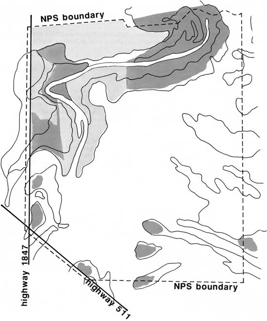
Tamaulipan Brushland and Salt Prairie. These two major vegetation zones on the battlefield (Figure 6) are described as follows:
Tamaulipan Brushland
This vegetation zone is mostly found in Cameron County along the higher and better drained (thus less salty) soils on the edges of the resacas. Recent biotic inventories emphasized the region's dense brushland, the latter supporting several of the threatened or endangered animal species of the area. An estimated 95 percent of this original native brushland in the LRGV is now devoted to agricultural or urban use (Parvin 1988). Preservation and restoration of this unique habitat is presently a high priority of the U.S. Fish and Wildlife Service and also the target of numerous state and private efforts.
Tamaulipan Brushland covers approximately 23 percent of the battlefield surface area, primarily on soils adjacent to the old remnant resacas of the Rio Grande. The densest vegetation is on levee soils (Type LAA) on either side of the old resaca on the northern side of the property. It extends along both sides of the drainage canal that forms the north boundary of Palo Alto Battlefield NHS (Figure 3), and along and within the old resaca. The levee soil continues along the southern side of the resaca, but the brush has been cleared for crop production. Levee brush is by far the most diverse and dense, although it suffers from grazing. Most of the remaining, non-levee brush on the battlefield is dominated by mesquite.
Tamaulipan Brushland overstory consists of Mesquite (Prosopis glandulosa), Granjeno (Celtis pallida), and Texas Ebony (Pithecellobium flexicaule). Lotebush (Zizyphus obtusifolia), snake eyes (Phaulothamnus spinescens), colima (Zanthoxylum fagara), brazil (Condalia Hookeri), prickly pear (Opuntia lindheimeri), and the native grass Sporobolus Wrighti dominate in the understory. Grazing has removed most other grasses from this area.
Less dense brushland, consisting largely of a Mesquite overstory and Granjeno, Colima, lotebush, Yucca treculeana and prickly pear understory, covers nonplowed transitional soils adjacent to the old resaca bed on the western side of the battlefield (Area C, Figure 3). This particular area of brushland is affected by grazing. Borrichia also grows in patches here, indicating the more saline nature of these soils. At the southwest corner and along the southern side of the battlefield, the densest brush occurs on small rises of a transitional soil type (LC). The vegetation makeup is the same, but supporting an occasional Texas ebony.
In the northern section of the battlefield, the transitional soil types (LC and CH) support a transitional vegetation structure, mesquite grassland. These soil types result in a gradation of dense brush close to the junction with soil type LAA, to sparse mesquite over Spartina spartinae. Often, there is less vegetation cover on the best LAA soils.
In general, the brushland is evergreen. Of the 38 or so brushland species, 5 are succulents and deciduous. Twenty-five of the remaining 33 species are semideciduous, depending on the severity of any particular drought. Some areas of brushland has been cleared for crop production. Type LAA soil often has been fertilized to improve either pasture or croplands in Cameron County, and the battlefield is no exception. Tamaulipan Brushland on the battlefield probably has changed little since 1846. However, cattle grazing has created some disturbed areas that allow invasion of herbaceous plants into this zone, and clearing of brush in some places has reduced its former extent.
|
| Figure 6. Dense brushland (dark shading), on the higher levee soils adjacent to the Resaca and old meanders. Plowed areas (light shading) are potential revegetation areas that should grow brush. Salt Prairies (unshaded areas) dominate. |
Salt Prairie
This zone covers approximately 77 percent of the battlefield surface area. It is comprised of sub-prairie zones of: 1) almost pure stands of cordgrass (Spartina spartinae), termed Sacatal prairie; 2) a mixed transition zone of Spartina spartinae and Borrichia frutescens (Figure 7); and 3) pure stands of Borrichia and succulents, termed Borrichia prairie. Areas of the battlefield having a sparse Mesquite overstory and Spartina understory are also considered salt prairie (Scifres et al. 1980:397-410). Salt prairie is significantly lower in elevation than Tamaulipan Brushland.
|
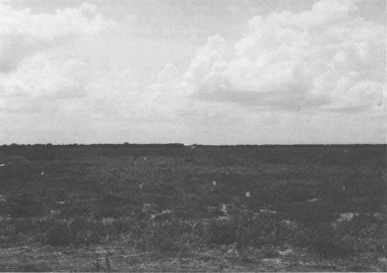
| Figure 7. Mixed Salt-Borrichia Prairies, in vicinity of Mexican battle line; Brushland-covered clay dune ("Arista Hill") on horizon. Pin flags mark artifact locations. Looking southeast. |
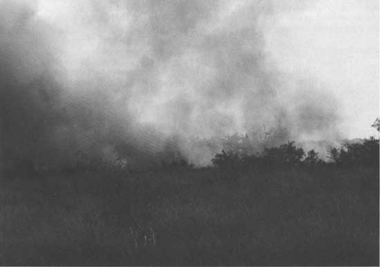
Cordgrass (Spartina) is by far the dominant grass in the Sacatal sub-prairie habitat. This grass grows to a height of 1-4 ft and provides cover for prairie species. Spartina can deal misery with its stiff, extremely sharp spine-tipped leaves and, as was demonstrated on the day of the battle, has the peculiar ability to burn readily while still green (Gould 1978:217) (Figure 8). Scattered mesquites and yuccas are locally common in places. Borrichia prairie generally defines slightly lower elevations, where salinity is liable to be higher, than lands containing salt intolerant Spartina. Thus, very little Spartina grows in the bottom of the old resacas even when pure stands of Spartina lie adjacent to the channel and only a foot higher in elevation.
|
| Figure 8. Burning off of mixed Cordgrass-Mesquite, encouraging new growth for grazing. |
The old resacas (soil type LM) generally qualify as ribbons of salt prairie because they are often dominated by Borrichia. Their generally lower elevation and wetter conditions, however, promote the sparse but regular existence of retama (Parkinsonia aculeata) and huisache (Acaxcia smallii) along the banks. Both plant species can withstand periods of standing water for months at a time. There is evidence land clearing has greatly increased the process of filling in the resacas. Cattle ranching and row crops caused other damage to the natural landscape and, in some places, this human impact has erased evidence of the original vegetation type.
As is usually the case for the area, the salt prairie has escaped regular plowing. A section of prairie in the middle of the site shows apparent effects of past row plowing in a series of evenly spaced bands. These bands are the result of field trials for non-native grasses that are palatable to cattle. Large areas of salt prairie, particularly in heavy Spartina areas, show signs of past burning. Such burns are common in the area to remove the old Spartina growth promoting new green shoots for grazing (Figure 8). It is likely salt prairie within the battlefield has changed relatively little since 1846. However, salt prairie may have spread into old, filled-in resaca beds, as well as into areas disturbed by ranching and farming.
Wildlife
Diversity of habitat types in the LRGV results in a diverse vertebrate fauna. About 700 vertebrate species are within the region, and approximately 500 of these are present year round (Bray and Irwin 1991). Of these species, 67 are considered endangered or threatened by the U.S. Department of Interior or the State of Texas. The two ecosystems included on the battlefield, that is, brushlands and salt prairie, are often listed in the habitat types for many of these species (Tewes and Everett 1982). Both habitat types provide food, nest sites and cover for wildlife species. Many neotropical species reach their northern limits in the LRGV, including two endangered cat species (Tewes and Everett 1982) and 21 bird species (Rappole and Klicka 1991; Chaney 1981). Invertebrate species receive little research. However, the same habitat alterations affecting vertebrate fauna must surely be detrimental to these species. The three habitat types of the battlefield site and surrounding area and their wildlife affinities are listed as follows:
Tamaulipan Brushland
The Tamaulipan Brushlands of the battlefield site suffer from both direct clearing for agriculture and grazing pressure. The highest wildlife diversity and abundances occurs in the brushlands of the site. Dense brush is of particular concern due to the endangered status of two native cats, the ocelot and jaguarundi. However, many other species also depend on such habitat for at least part of their life cycle.
Salt Prairie
This habitat has come under increasing concern as more research is done on wildlife species occurring there. Salt prairie contains a mixture of wetlands and grassy native flats supporting both seasonal and year-round species. For instance, the endangered Aplomado falcon nests in the brushy areas but forages largely in the open prairie.
Wetlands
The seasonal nature of the wetlands of the battlefield site in combination with their shallowness could be valuable to several species. Wading birds are fundamentally limited to a certain water depth when foraging. Large numbers of such species were observed feeding in flooded resaca beds both on the battlefield and on surrounding lands (Farmer 1992:15). Several species of amphibians unique to the LRGV are adapted to survive in such wetlands during dry periods.
| <<< Previous | <<< Contents>>> | Next >>> |
paal/thunder-cannon/chap2.htm
Last Updated: 25-Feb-2009