|
OZARK
Ozark Rivers National Monument A Proposal |

|
THE PLAN
Shown on the accompanying plate is a preliminary land-use and development plan for the proposed National Monument. While the boundaries are tentative, they define the shape and size of an area on the Current and Eleven Point Rivers necessary for the protection of natural values, and adequate for anticipated development.
The proposed Monument comprises approximately 113,000 acres of land. Of this, about 16 percent is now owned by either the State or Federal governments; the other 84 percent is in private ownership. About 190 miles of river are included. Of this, 117 miles would be on the Current—84 miles of it in one continuous stretch—39 miles on Jacks Fork and 34 miles on the Eleven Point. Within these boundaries, would be 13 named caves, 11 interesting geological sites, more than 40 archeological sites, 4 of which may prove important, a number of fine ecological sites, and a great many springs. Six springs, having a flow of 65 million gallons or more per day, are included within the proposed Monument boundaries or in adjacent State parks. There are 13 others of considerable size and many smaller ones.
The selection and development of areas for public use and enjoyment will be governed by a number of factors. As tentatively designated on the accompanying drawings, weight was given primarily to the locations of important points of interest—some to be developed for public use, others to be left undisturbed—to river use which might normally be expected to develop, and to an analysis of the distribution of areas which would effect zoning for preservation and use.
As a general pattern, developed areas are distributed about 15 to 20 miles apart. A somewhat heavier concentration is suggested in the central Cardareva Section where, because of its location, size and variety of attractions, heavier public use and more diversified development would be logical.
These developed areas would vary in size and scope. Each would probably contain interpretive facilities, campgrounds, picnic areas, boating facilities, and possibly concessions for meals and supplies. Each would probably be served by trails for hiking and perhaps horseback riding. One, perhaps at centrally located Owls Bend, might represent the center for the interpretive program and contain, therefore, a visitor center plus necessary administrative facilities.
Additional access points, in effect minor developed areas in most cases, are scattered generally with an average spacing of 7 or 8 miles. In the more primitive sections, they would be farther apart and with less refinement. In the more heavily used sections, they might be closer together and with simple development providing access, parking, and perhaps for boat landing and picnicking. They would serve also as access to trail systems.
For convenience, more detailed discussion of the plan follows, by section, as covered in the accompanying drawings.
Upper Current Section
This section at the headwaters of the Current River would contain approximately 21,000 acres. It, together with Cardareva Section, would provide an uninterrupted publicly-owned 90 miles of river from Montauk State Park to a point near Van Buren on the Current and up Jacks Fork to a point near Eminence. The preservation of outstanding scenery and a fine feeling of wilderness would be paramount here. Developments would be kept few and simple. This section incorporates also a number of very fine features—Round Spring Cavern, Ashley Cave, Welch Spring, The Sunkland and Sink, Devils Well, and the Sinks. Each of these would be points of public interest and would require access by trail or road and at least minor interpretive developments. Existing Montauk and Round Spring State Parks, not part of the Monument but contiguous to it, would continue to serve the public as major developed areas. Additional development is suggested at Akers Ferry and access at Boyds Creek, possibly with minor facilities.
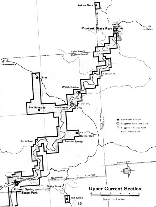
|
| Upper Current Section. (click on image for a PDF version) |
Cardareva Section
This centrally located section contains the largest block of land for inclusion in the proposed Monument, amounting to some 49,800 acres. Here Jacks Fork joins the Current, offering a natural center for river boating. Here too are a variety of interesting sites and the space and topography suitable for more concentrated use—Blue Spring, Rocky Falls, Cardareva Mountain, Paint Rock, Big Creek, and Chilton Creek. Tentatively it appears that major use and development might be at Owls Bend, serving as interpretive and administrative center for the Monument. Junction Ferry and Blue Spring are also suggested for development. From these sites also would radiate major trail systems along the rivers and through the wooded hills themselves. Access and minor development as needed would serve the other points of interest—possibly at Big Creek, Cardareva, Paint Rock, and Chilton Creek.
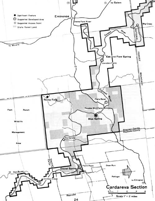
|
| Cardareva Section. (click on image for a PDF version) |
Lower Current Section
Below Van Buren,, the Current River broadens into a wider stream and the valley through which it flows for 32 miles takes on a more open character though still highly attractive. For much of this distance, the proposed Monument area lies within Clark National Forest in an area where the U.S. Forest Service recognizing its value for recreation has zoned it for that purpose. Running between Van Buren and Doniphan as it does, this section offers a natural opportunity for float or boat trips readily accessible and of a length which should prove popular. Because of these characteristics, the river could stand more public use than in the upper reaches and as a result, would serve in part to relieve pressures on those more fragile and primitive areas. One of the major and well-developed State parks, Big Spring, lies at the northern end of this section and would continue to serve as a major center for public use and enjoyment. An additional development area is suggested near the southern end of the section in the vicinity of Float Camp #7, now developed and managed by the U. S. Forest Service. A third area might be located at Phillips Bay. An existing float camp nearby provides limited picnic and camping facilities. These several areas plus access and possibly minor development at Cave Spring, Colvin Bay, and Dark Bay would provide a flexible variety of recreation opportunities for large numbers of people.
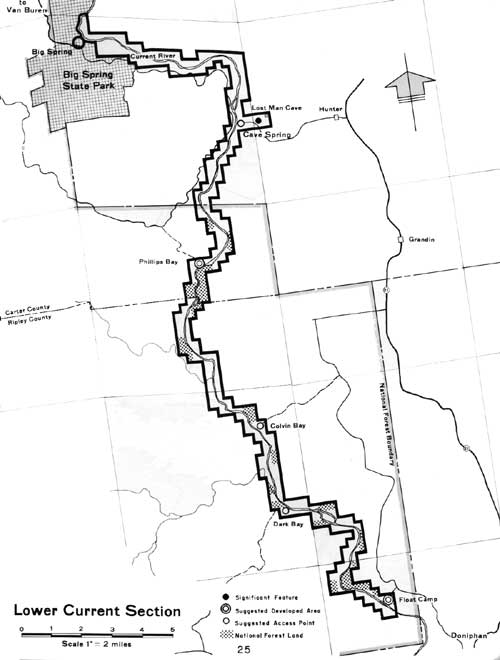
|
| Lower Current Section. (click on image for a PDF version) |
Jacks Fork Section
Approximately 39 miles of river in 17,160 acres would be contained in this section. Jacks Fork, a branch of the Current River, is probably the wildest and least accessible country within the proposed Monument and includes outstanding scenery and a number of fine features. Development in this section should be limited to providing a minimum number of access points necessary for river use plus a few minor-day use areas. In fact, no development of any great consequence would be considered above Alley Spring State Park. The latter will continue to provide for a variety of activities along with preservation of Alley Spring and related Red Mill, now restored. Jam Up Cave, one of the most striking and unique features of the Monument, would be a point of considerable public interest. Access and interpretive aids would be provided to make it available to the public. Minor developments are suggested for Blue Spring and near the Highway 17 crossing. Access is suggested in the vicinity of Rymer Ranch-Bunker Hill and at one other point which might serve as a float camp. Preservation of the fragile wilderness quality of this stream and its beautiful setting would be paramount in planning for both public use and facilities.
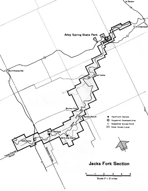
|
| Jacks Fork Section. (click on image for a PDF version) |
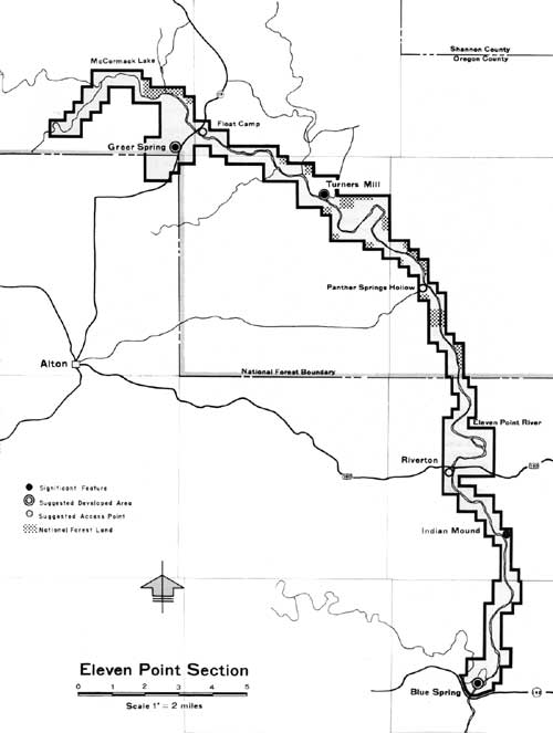
Eleven Point Section
This section is somewhat separated from the other four, lying in a different drainage which joins the Black River farther south in Arkansas. Upstream, it is quite similar to the Jacks Fork and Upper Current and of nearly the same quality. Approximately 34 miles of river and 14,000 acres of land are included extending from a point several miles above Greer Spring downstream to Highway 142. Roughly two-thirds, by river miles, lies within Clark National Forest. No existing facilities for public use have been provided; however, as in the case of the Lower Current, the U. S. Forest Service has zoned a stretch along the river for recreation, recognizing that as the primary value.
The Eleven Point Section includes a number of interesting spots and features—extremely attractive Greer Spring and Mill, historically interesting Turners Mill about midpoint, and Blue Spring at the southern end not far from the Arkansas line. Development is suggested at Turners Mill because of its location and the surrounding open and relatively level land. The general locations of Greer and Blue Springs also appear logical for development. Minor areas where access and simple development may be desirable, primarily in connection with float trips, include Panther Spring Hollow, a location near Riverton where U.S. Highway 160 crosses the river, and one additional float campsite. Indian mounds at Blue Spring and Pigman Ranch may prove to be of considerable archeological significance. On further investigation, provision of on-site interpretive facilities where this story can be told may be desirable.
|
| Eleven Point Section. (click on image for a PDF version) |
| <<< Previous | <<< Contents>>> | Next >>> |
proposal/sec5.htm
Last Updated: 04-Nov-2009