|
Oregon Caves Cultural Landscape Report |

|
ANALYSIS AND EVALUATION (continued)
CIRCULATION
|
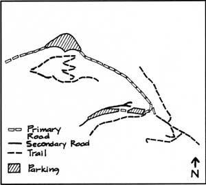
Roads and trails were the first features implemented from the USFS 1917 general development plan. Oregon Caves Highway (SR46), the primary access route, winds 19.5 miles southeast from Cave Junction and terminates at the monument's main parking lot entrance. Constructed in 1922, the completion of SR46 initiated permanent resort development at the monument. No significant changes in alignment have occurred. As the primary means of ingress and egress," SR46 reflects the intent of early forest road design wherein location "in relation to scenic vista and the beauties of the natural enviroument was encouraged." [15] In 1923, a service road was built connecting SR46 with the cave entrance. To allow guests to park overnight near lodging, the narrow road was extended west in 1929 and again in 1934. Log railing lined the service road and cave entrance area until 1952. By 1960 asphalt surfacing came into use and stone walls had replaced the log railing as curbing. After the 1964 flood several sections of the wall were rebuilt. Topographic constraints have limited parking to the lower lot and a smaller area west of the Chateau. The lower has been enlarged twice since 1922, and a concrete traffic island installed in the 1950s. During this period and through the 1960s the lot has received extensive repairs due to landslide activity. Overnight guest parking has existed at an area west of the cave guest entrance since 1929. Concession employees park at a widened bend in the road further west of the proposed historic district and project area boundary. The walkway leading to the Chalet and the main cave entrance is a remnant of the first rough trails blazed to Oregon Caves in 1886. The walkway was graded and paved in 1923 as part of site development by the Oregon Caves Company. Flood damage necessitated repair work in early 1965. In 1940, a stone retaining wall containing seating was constructed along the walkway. The Chateau courtyard walkway, leading from the road to the lower pond, was a 1935 CCC project, paved in 1952. Four trails begin from the developed area of the monument. In 1922," starting east from the Chalet," the USFS constructed the Lake Mountain Trail, and branching from it," the Big Tree Trail. In 1931 USFS constructed Cave Exit Trail," terminating within ten yards of the cave entrance, was widened by CCC crew in 1935-37. As part of the same project, the Cllff Nature Trail, which connects the Cave Exit Trail with the Lake Mountain Trail was constructed. The No Name loop trail starts north from the Chateau following Cave Creek and returns to the service road west of the structure. These trails connect the monument to other hiking trails of the Siskiyou National Forest. |
 NPS Administration 1934-1941  ORCA 1941-1990 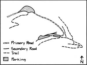 Concession Development, 1909-1934 |
| <<< Previous | <<< Contents >>> | Next >>> |
orca/clr/clr2c.htm
Last Updated: 05-Feb-2002