|
Oregon Caves Cultural Landscape Report |

|
ANALYSIS AND EVALUATION (continued)
SPATIAL ORGANIZATION
|
Narrow topographic benches, one formed by Cave Creek and the other located north at the monument entrance were improved to provide area for development. Both benches hold visitor concession and administration developments that have spatially characterized the monument since its establishment. Construction of road access to the caves from the northwest in 1922 allowed for concession development at the canyon apex. Parking requirements could be satisfied at the north bench and smaller benches to the southwest of the cave entrance. Though the monument is under NPS administration, concession operations have been the primary focus and organizing feature of site development. Definition of administrative space was not made until construction of the Ranger Residence in 1935. Administration held secondary spatial stance until 1941, when the Checking and Comfort Station, located at the upper parking lot, more clearly delineated NPS management of the monument. Spatial development eventually evolved to reflect the dual function of the monument-recreation and management of a natural resource. |
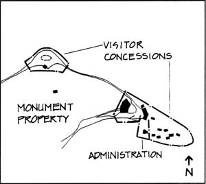 NPS Administration 1934-1941 |
 Concession Development, 1909-1934 |
 ORCA 1941-1990 |
| <<< Previous | <<< Contents >>> | Next >>> |
orca/clr/clr2a.htm
Last Updated: 05-Feb-2002