|
THE BOOK OF THE NATIONAL PARKS
|
THE VOLCANIC NATIONAL PARKS
VII
LASSEN PEAK AND MOUNT KATMAI
THE ONE A NATIONAL PARK IN NORTHERN CALIFORNIA, THE OTHER A NATIONAL MONUMENT IN ALASKA
BECAUSE most of the conspicuous volcanic eruptions of our day have occurred in warmer climes nearer the equator, we usually think of volcanoes as tropical, or semi-tropical, phenomena. Vesuvius is in the Mediterranean, Pelee in the Caribbean, Mauna Loa and Kilauea on the Hawaiian Islands. Of course there is Lassen Peak in California—the exception, as we say, which proves the rule.
As a fact, many of the world's greatest volcanoes are very far indeed from the tropics. Volcanoes result from the movement of earth masses seeking equilibrium underneath earth's crust, but near enough to the surface to enable molten rock under terrific pressure to work upward from isolated pockets and break though. Volcanoes occur in all latitudes. Even Iceland has its great volcano. It is true that the volcano map shows them congregating thickly in a broad band, of which the equator is the centre, but it also shows them bordering the Pacific Coast from Patagonia to Alaska, crossing the ocean though the Aleutian Islands, and extending far down the Asian coast. It also shows many inland volcanoes, isolated and in series. The distribution is exceedingly wide.
Volcanoes usually occur in belts which may or may not coincide with lines of weakening in the earth's crust below. Hence the series of flaming torches of prehistoric days which, their fires now extinguished and their sides swathed in ice, have become in our day the row of spectacular peaks extending from northern California to Puget Sound. Hence also the long range of threatening summits which skirts Alaska's southern shore, to-day the world's most active volcanic belt. Here it was that Katmai's summit was lost in the mighty explosion of June, 1912, one of enormous violence, which followed tremendous eruptions else where along the same coast, and is expected to be followed by others, perhaps of even greater immensity and power.
These two volcanic belts contain each an active volcano which Congress has made the centre of a national reservation. Lassen Peak, some wise men believe, is the last exhibit of activity in the dying volcanism of the Cascade Mountains. Mount Katmai is the latest and greatest exhibit in a volcanic belt which is believed to be young and growing.
THE BUILDING OF THE CASCADES
Millions of years ago, in the period which geologists call Tertiary, the pressure under that part of the crust of the earth which now is Washington, Oregon, and northern California, became too powerful for solid rock to withstand. Long lines of hills appeared parallel to the sea, and gradually rose hundreds, and perhaps thousands, of feet. These cracked, and from the long summit-fissures issued hot lava, which spread over enormous areas and, cooling, laid the foundations for the coming Cascade Mountains.
When the gaping fissures eased the pressure from beneath, they filled with ash and lava except at certain vent holes, around which grew the volcanoes which, when their usefulness as chimneys passed, became those cones of ice and snow which now are the glory of our northwest.
There may have been at one time many hundreds of these volcanoes, big and little. Most of them doubtless quickly perished under the growing slopes of their larger neighbors, and, as they became choked with ash, the lava which had been finding vent through them sought other doors of escape, and found them in the larger volcanoes. Thus, by natural selection, there survived at last that knightly company of monsters now uniformed in ice, which includes, from north to south, such celebrities as Mount Baker, Mount Rainier, Mount Adams, Mount St. Helens, Mount Hood, vanished Mount Mazama, Mount Shasta, and living Lassen Peak.
Whether or not several of these vast beacons lit Pacific's nights at one time can never be known with certainty, but probability makes the claim. Whether or not in their decline the canoes of prehistoric men found harbor by guidance of their pillars of fire by night, and their pillars of smoke by day is less probable but possible. One at least of the giant band, Lassen Peak, is semi-active to-day. At least two others, Mount Rainier and Mount Baker, offer evidences of internal heat beneath their mail of ice. And early settlers in the northwest report Indian traditions of the awful cataclysm in which Mount Rainier lost two thousand feet of cone.
LASSEN PEAK NATIONAL PARK
Lassen Peak, the last of the Cascades in active eruption, rises between the northern end of the Sierra Nevada Mountains, of which it is locally but wrongly considered a part, and the Klamath Mountains, a spur of the Cascades. Actually it is the southern terminus of the Cascades.
Though quiet for more than two hundred years, the region long has enjoyed scientific and popular interest because it possesses hot springs, mud volcanoes and other minor volcanic phenomena, and particularly because its cones, which are easily climbed and studied, have remained very nearly perfect. Besides Lassen Peak, whose altitude is 10,437 feet, there are others of large size and great interest close by. Prospect Peak attains the altitude of 9,200 feet; Harkness Peak 9,000 feet; and Cinder Cone, a specimen of unusual beauty, 6,907 feet.
Because it seemed desirable to conserve the best two of these examples of recent volcanism, President Taft in 1906 created the Lassen Peak and the Cinder Cone National Monuments. Doubtless there would have been no change in the status of these reservations had not Lassen Peak broken its long sleep in the spring of 1914 with a series of eruptions covering a period of nineteen months. This centred attention upon the region, and in August, 1916, Congress created the Lassen Volcanic National Park, a reservation of a hundred and twenty-four square miles, which included both national monuments, other notable cones of the neighborhood, and practically all the hot springs and other lesser phenomena. Four months after the creation of the national park Lassen Peak ceased activity with its two hundred and twelfth eruption. It is not expected to resume. For some years, however, scientists will continue to class it as semi-active.
These eruptions, none of which produced any considerable lava flow, are regarded as probably the dying gasps of the volcanic energy of the Cascades. They began in May, 1914, with sharp explosions of steam and smoke from the summit crater. The news aroused wide-spread interest throughout the United States; it was the first volcanic eruption within the national boundaries. During the following summer there were thirty-eight slight similar eruptions, some of which scattered ashes in the neighborhood. The spectacle was one of magnificence because of the heavy columns of smoke. Eruptions increased in frequency with winter, fifty-six occurring during the balance of the year.
About the end of March, 1915, according to Doctor J. S. Diller of the United States Geological Survey, new lava had filled the crater and overflowed the west slope a thousand feet. On May 22 following occurred the greatest eruption of the series. A mushroom-shaped cloud of smoke burst four miles upward in air. The spectacle, one of grandeur, was plainly visible even from the Sacramento Valley. "At night," writes Doctor Diller, "flashes of light from the mountain summit, flying rocket-like bodies and cloud-glows over the crater reflecting the light from incandescent lavas below, were seen by many observers from various points of view, and appear to indicate that much of the material erupted was sufficiently hot to be luminous."
|
|
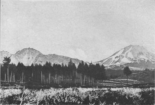
LASSEN PEAK SEEN FROM THE SOUTHWEST On the left is the material last erupted from the slope of the peak. It is called Chaos From a photograph by J. S. Diller |
|
|
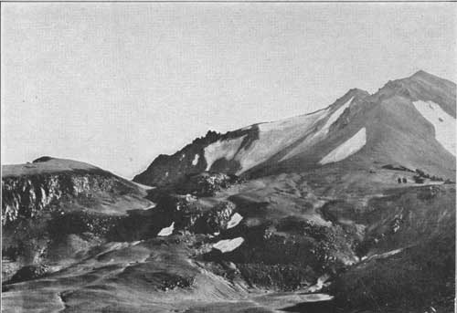
LASSEN PEAK CLOSE UP Showing the northeast slope as seen from Chaos From a photograph by J. S. Diller |
Another interesting phenomenon was the blast of superheated gas which swept down Lost Creek and Hot Creek Valleys. For ten miles it withered and destroyed every living thing in its path. Large trees were uprooted. Forests were scorched to a cinder. Snow-fields were instantly turned to water and flooded the lower valleys with rushing tides.
Later examination showed that this explosion had opened a new fissure, and that the old and new craters, now joined in one, were filled with a lava lid. Following this, the eruptions steadily declined in violence till their close the following December.
As a national park, though undeveloped and unequipped as yet, Lassen has many charms besides its volcanic phenomena. Its western and southern slopes are thickly forested and possess fine lakes and streams. Several thousand persons, largely motorists, have visited it yearly of late. There are hot springs at Drakesbad, just within the southern border, which have local popularity as baths. The trout-fishing in lake and stream is excellent, and shooting is encouraged in the extensive national forest which surrounds the park, but not in the park itself, which is sanctuary. In spite of the hunting, deer are still found.
The greatest pleasure, however, will be found in exploring the volcanoes, from whose summits views are obtainable of many miles of this tumbled and splendidly forested part of California and of the dry plains of the Great Basin on its east.
THE KATMAI NATIONAL MONUMENT
We turn from the dying flutter of California's last remaining active volcano to the excessive violence of a volcano in the extremely active Alaskan coast range. The Mount Katmai National Monument will have few visitors because it is inaccessible by anything less than an exploring-party. We know it principally from the reports of four expeditions by the National Geographic Society. Informed by these reports, President Wilson created it a national monument in 1918.
A remarkable volcanic belt begins in southern Alaska at the head of Cook Inlet, and follows the coast in a broad southwesterly curve fifteen hundred miles long through the Alaskan Peninsula to the end of the Aleutian Islands, nearly enclosing Behring Sea. It is very ancient. Its mainland segment contains a dozen peaks, which are classed as active or latent, and its island segment many other volcanoes. St. Augustine's eruption in 1883 was one of extreme violence. Kugak was active in 1889. Veniaminof's eruption in 1892 ranked with St. Augustine's. Redoubt erupted in 1902, and Katmai, with excessive violence, in June, 1912. The entire belt is alive with volcanic excitement. Pavlof, at the peninsula's end, has been steaming for years, and several others are under expectant scientific observation. Katmai may be outdone at any time.
Katmai is a peak of 6,970 feet altitude, on treacherous Shelikof Strait, opposite Kodiak Island. It rises from an inhospitable shore far from steamer routes or other recognized lines of travel. Until it announced itself with a roar which was heard at Juneau, seven hundred and fifty miles away, its very existence was probably unknown except to a few prospectors, fishermen, geographers, and geologists. Earthquakes followed the blast, then followed night of smoke and dust. Darkness lasted sixty hours at Kodiak, a hundred miles away. Dust fell as far as Ketchikan, nine hundred miles away. Fumes were borne on the wind as far as Vancouver Island, fifteen hundred miles away. Weather Bureau reports noted haziness as far away as Virginia during succeeding weeks, and the extraordinary haziness in Europe during the following summer is noted by Doctor C. S. Abbott, Director of the Astrophysical Observatory of the Smithsonian Institution, in connection with this eruption.
Nevertheless, Katmai's is by no means the greatest volcanic eruption. Katmai's output of ash was about five cubic miles. Several eruptions have greatly exceeded that in bulk, notably that of Tomboro, in the island of Sumbawa, near Java, in 1815, when more than twenty-eight cubic miles of ash were flung to the winds. Comparison with many great eruptions whose output was principally lava is of course impossible.
The scene of this explosion is the national monument of to-day. The hollowed shell of Katmai's summit is a spectacle of wonderment and grandeur. Robert F. Griggs, who headed the expeditions which explored it, states that the area of the crater is 8.4 square miles, measured along the highest point of the rim. The abyss is 2.6 miles long, 7.6 miles in circumference, and 4.2 square miles in area. A lake has formed within it which is 1.4 miles long and nine-tenths of a mile wide. Its depth is unknown. The precipice from the lake to the highest point of the rim measures thirty-seven hundred feet.
The most interesting exhibit of the Katmai National Monument, however, is a group of neighboring valleys just across the western divide, the principal one of which Mr. Griggs, with picturesque inaccuracy, named the "Valley of Ten Thousand Smokes"; for, from its floor and sides and the floors and sides of smaller tributary valleys, superheated steam issues in thousands of hissing columns. It is an appalling spectacle. The temperatures of this steam are extremely high; Griggs reports one instance of 432 degrees Centigrade, which would equal 948 degrees Fahenheit; in some vents he found a higher temperature at the surface than a few feet down its throat. The very ground is hot.
This phenomenal valley is not to be fully explained offhand; as Griggs says, there are many problems to work out. The steam vents appear to be very recent. They did not exist when Spurr crossed the valley in 1898, and Martin heard nothing of them when he was in the near neighborhood in 1903 and 1904. The same volcanic impulse which found its main relief in the explosive eruption of near-by Katmai in 1912 no doubt cracked the deep-lying rocks beneath this group of valleys, exposing super-heated rocks to subterranean waters which forthwith turned to steam and forced these vents for escape. Griggs reports that volcanic gases mingle freely with the steam.
The waters may have one or more of several sources; perhaps they come from deep springs originating in surface snows and rains; perhaps they seep in from the sea. Whatever their origin the region especially interests us as a probably early stage of phenomena whose later stages find conspicuous examples in several of our national parks. Some day, with the cooling of the region, this may become the valley of ten thousand hot springs.
But it is useful and within scientific probability to carry this conception much further. The comparison between Katmai's steaming valleys and the geyser basin of Yellowstone is especially instructive because Yellowstone's basins doubtless once were what Katmai's steaming valleys are now. The "Valley of Ten Thousand Smokes" may well be a coming geyser-field of enormous size. The explanation is simple. Bunsen's geyser theory, now generally accepted, presupposes a column of water filling the geyser vent above a deep rocky superheated chamber, in which entering water is being rapidly turned into steam. When this steam becomes plentiful enough and sufficiently compressed to overcome the weight of the water in the vent, it suddenly expands and hurls the water out. That is what makes the geyser play.
Now one difference between the Yellowstone geyser-fields and Katmai's steaming valleys is just a difference in temperature. The entire depth of earth under these valleys is heated far above boiling-point, so that it is not possible for water to remain in the vents; it turns to steam as fast as it collects and rushes out at the top in continuous flow. But when enough thousands of centuries elapse for the rocks between the surface and the deep internal pockets to cool, the water will remain in many vents as water until, at regular intervals, enough steam gathers be low to hurl it out. Then these valleys will become basins of geysers and hot springs like Yellowstone's.
| <<< Previous | <<< Contents>>> | Next >>> |
yard3/chap7.htm
Last Updated: 30-Oct-2009