|
THE BOOK OF THE NATIONAL PARKS
|
THE GRAND CANYON AND OUR NATIONAL MONUMENTS
XVII
THE RAINBOW OF THE DESERT
ZION NATIONAL MONUMENT, SOUTHERN UTAH. AREA, 120 SQUARE MILES
WHEN, in the seventies, Major J. W. Powell, the daring adventurer of the Grand Canyon, faced Salt Lake City on his return from one of his notable geological explorations of the southwest, he laid his course by a temple of rock "lifting its opalescent shoulders against the eastern sky." His party first sighted it across seventy miles of a desert which "rose in a series of Cyclopean steps." When, climbing these, they had seen the West Temple of the Virgin revealed in the glory of vermilion body and shining white dome, and had gazed between the glowing Gates of Little Zion into the gorgeous valley within, these scenery-sated veterans of the Grand Canyon and the Painted Desert passed homeward profoundly impressed and planning quick return.
No wonder that Brigham Young, who had visited it many years before with a party of Mormons seeking a refuge in event of Indian raids or of exile from their Zion, Salt Lake City, had looked upon its glory as prophetic, and named it Little Zion.
Geologists found the spot a fruitful field of study. They found it also a masterpiece of desert beauty.
"Again we are impressed with the marvellous beauty of outline, the infinite complication of these titanic buttes," wrote F. S. Dellenbaugh, topographer of the Powell party, on his second visit. "It is doubtful if in this respect the valley has its equal. Not even the Grand Canyon offers a more varied spectacle; yet all is welded together in a superb ensemble."
"Nothing can exceed the wondrous beauty of Little Zion Canyon," wrote C. E. Dutton. "In its proportions it is about equal to Yosemite, but in the nobility and beauty of its sculptures there is no comparison. It is Hyperion to a Satyr. No wonder the fierce Mormon zealot who named it was reminded of the Great Zion on which his fervid thoughts were bent, of houses not built with hands, eternal in the heavens.
And Doctor G. K. Gilbert, whose intimate study of its recesses has become a geological classic, declared it "the most wonderful defile" that it had been even his experienced fortune, to behold.
Technical literature contains other outbursts of enthusiastic admiration, some of eloquence, hidden, however, among pages so incomprehensible to the average lover of the sublime in Nature that the glory of Little Zion was lost in its very discovery. So remote did it lie from the usual lines of travel and traffic that, though its importance resulted in its conservation as a national monument in 1909, it was six or seven years more before its fame as a spectacle of the first order began to get about. The tales of adventurous explorers, as usual, were discounted. It was not until agencies seeking new tourist attractions sent parties to verify reports that the public gaze was centred upon the canyon's supreme loveliness.
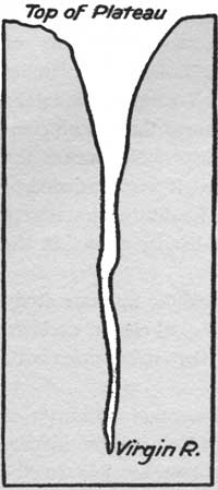
To picture Zion one must recall that the great plateau in which the Virgin River has sunk these canyons was once enormously higher than now. The erosion of hundreds of thousands, or, if you please, millions of years, has cut down and still is cutting down the plateau. These "Cyclopean steps," each step the thickness of a stratum or a series of strata of hardened sands, mark progressive stages in the decomposition of the whole.
Little Zion Canyon is an early stage in Nature's process of levelling still another sandstone step, that is all; this one fortunately of many gorgeous hues. From the top of this layer we may look down thousands of vertical feet into the painted canyon whose river still is sweeping out the sands that Nature chisels from the cliffs; or from the canyon's bottom we may look up thousands of feet to the cliffed and serrated top of the doomed plateau. These ornate precipices were carved by trickling water and tireless winds. These fluted and towered temples of master decoration were disclosed when watery chisels cut away the sands that formerly had merged them with the ancient rock, just as the Lion of Lucerne was disclosed for the joy of the world when Thorwaldsen's chisel chipped away the Alpine rock surrounding its unformed image.
The colors are even more extraordinary than the forms. The celebrated Vermilion Cliff, which for more than a hundred miles streaks the desert landscape with vivid red, here combines spectacularly with the White Cliff, another famous desert feature—two thousand feet of the red surmounted by a thousand feet of the white. These constitute the body of color.
But there are other colors. The Vermilion Cliff rests upon the so-called Painted Desert stratum, three hundred and fifty feet of a more insistent red relieved by mauve and purple shale. That in turn rests upon a hundred feet of brown conglomerate streaked with gray, the grave of reptiles whose bones have survived a million years or more. And that rests upon the greens and grays and yellows of the Belted Shales.
Nor is this all, for far in the air above the wonderful White Cliff rise in places six hundred feet of drab shales and chocolate limestones intermixed with crimsons whose escaping dye drips in broad vertical streaks across the glistening white. And even above that, in places, lie remnants of the mottled, many-colored beds of St. Elmo shales and limestones in whose embrace, a few hundred miles away, lie embedded the bones of many monster dinosaurs of ages upon ages ago.
Through these successive layers of sands and shales and limestones, the deposits of a million years of earth's evolution, colored like a Roman sash, glowing in the sun like a rainbow, the Virgin River has cut a vertical section, and out of its sides the rains of centuries of centuries have detached monster monoliths and temples of marvellous size and fantastic shape, upon whose many-angled surfaces water and wind have sculptured ten thousand fanciful designs and decorations.
The way in to this desert masterpiece of southern Utah is a hundred miles of progressive preparation. From railroad to canyon there is not an unuseful mile or hour. It is as if all were planned, step by step, to make ready the mind of the traveller to receive the revelation with fullest comprehension.
To one approaching who does not know the desert, the motion-picture on the screen of the car-window is exciting in its mystery. These vast arid bottom-lands of prehistoric Lake Bonneville, girded by mountain groups and ranges as arid as the sands from which they lift their tawny sides, provoke suggestive questions of the past.
In this receptive mood the traveller reaches Lund and an automobile. The ride to Cedar City, where he spends the night, shows him the sage-dotted desert at close range. His horizon is one of bare, rugged mountains. In front of him rise the "Cyclopean steps" in long, irregular, deeply indented sweeps. The vivid Pink Cliff, which, had it not long since been washed away from Little Zion, would have added another tier of color to its top, here, on the desert, remains a distant horizon. The road climbs Lake Bonneville's southern shore, and, at Cedar City, reaches the glorified sandstones.
|
|
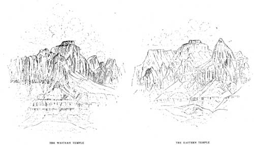
THE WESTERN TEMPLE (left), THE EASTERN TEMPLE (right) OUTLINES OF THE WESTERN AND EASTERN TEMPLES, ZION NATIONAL MONUMENT From drawings by William H. Holmes |
From Cedar City to the canyon one sweeps through Mormon settlements founded more than sixty years ago, a region of stream-watered valleys known of old as Dixie. The road is part of the Arrowhead Trail, once in fact a historic trail, now a motor-highway between Salt Lake and Los Angeles. The valleys bloom. Pomegranates, figs, peaches, apricots, melons, walnuts, and almonds reach a rare perfection. Cotton, which Brigham Young started here as an experiment in 1861, is still grown. Lusty cottonwood-trees line the banks of the little rivers. Cedars dot the valleys and cover thickly the lower hills. And everywhere, on every side, the arid cliffs close in. The Pink Cliff has been left behind, but the Vermilion Cliff constantly appears. The White Cliff enters and stays. Long stretches of road overlie one and another colored stratum; presently the ground is prevailingly red, with here and there reaches of mauve, yellow, green, and pink.
Cedar City proves to be a quaint, straggling Mormon village with a touch of modern enterprise; south of Cedar City the villages lack the enterprise. The houses are of a gray composition resembling adobe, and many of them are half a century old and more. Dilapidated square forts, reminders of pioneer struggles with the Indians, are seen here and there. Compact Mormon churches are in every settlement, however small. The men are bearded, coatless, and wear baggy trousers, suggestive of Holland. Bronzed and deliberate women, who drive teams and work the fields with the men, wear old-fashioned sunbonnets. Many of these people have never seen a railroad-train. Newspapers are scarce and long past date. Here Mormonism of the older fashion is a living religion, affecting the routine of daily life.
Dixie is a land of plenty, but it is a foreign land. It is reminiscent, with many differences, of an Algerian oasis. The traveller is immensely interested. Somehow these strange primitive villages, these simple, earnest, God-fearing people, merge into unreality with the desert, the sage-dotted mountains, the cedar-covered slopes, the blooming valleys, the colored sands, and the vivid cliffs.
Through Bellevue, Toquerville, the ruins of Virgin City, Rockville, and finally to Springdale winds the road. Meantime the traveller has speeded south under the Hurricane Cliff, which is the ragged edge left when all the land west of it sank two thousand feet during some geologic time long past. He reaches the Virgin River where it emerges from the great cliffs in whose recesses it is born, and whence it carries in its broad muddy surge the products of their steady disintegration.
From here on, swinging easterly up-stream, sensation hastens to its climax. Here the Hurricane Cliff sends aloft an impressive butte painted in slanting colors and capped with black basalt. Farther on a rugged promontory striped with vivid tints pushes out from the southern wall nearly to the river's brink. The cliffs on both sides of the river are carved from the stratum which geologists call the Belted Shales. Greenish-grays, brownish-yellows, many shades of bright red, are prominent; it is hard to name a color or shade which is not represented in its horizontal bands. "The eye tires and the mind flags in their presence," writes Professor Willis T. Lee. "To try to realize in an hour's time the beauty and variety of detail here presented is as useless as to try to grasp the thoughts expressed in whole rows of volumes by walking through a library."
Far up the canyon which North Creek pushes through this banded cliff, two towering cones of glistening white are well named Guardian Angels—of the stream which roars between their feet. Eagle Crag, which Moran painted, looms into view. On the south appears the majestic massing of needle-pointed towers which Powell named the Pinnacles of the Virgin. The spectacular confuses with its brilliant variations.
At the confluence of the Virgin River and its North Fork, known of old as the Parunuweap and the Mukuntuweap, the road sweeps northward up the Mukuntuweap. There have been differing reports of the meaning of this word, which gave the original name to the national monument. It has been popularly accepted as meaning "Land of God," but John R. Wallis, of St. George, Utah, has traced it to its original Indian source. Mukuntuweap, he writes, means "Land of the Springs," and Parunuweap "Land of the Birds."
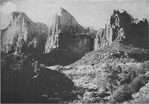
Reaching Springdale, at the base of the Vermilion Cliff, the traveller looks up-stream to the valley mouth through which the river emerges from the cliffs, and a spectacle without parallel meets his eye. Left of the gorgeous entrance rises the unbelievable West Temple of the Virgin, and, merging with it from behind, loom the lofty Towers of the Virgin. Opposite these, and back from the canyon's eastern brink, rises the loftier and even more majestic East Temple of the Virgin. Between them he sees a perspective of red and white walls, domes, and pinnacles which thrills him with expectation.
And so, fully prepared in mind and spirit, awed and exultant, he enters Zion.
Few natural objects which have been described so seldom have provoked such extravagant praise as the West Temple. It is seen from a foreground of gliding river, cotton-wood groves, and talus slopes dotted with manzanita, sage, cedars, and blooming cactus. From a stairway of mingled yellows, reds, grays, mauves, purples, and chocolate brown, it springs abruptly four thousand feet. Its body is a brilliant red. Its upper third is white. It has the mass and proportions, the dignity and grandeur, of a cathedral. It is supremely difficult to realize that it was not designed, so true to human conception are the upright form and mass of its central structure, the proportioning and modelling of its extensive wings and buttresses. On top of the lofty central rectangle rests, above its glistening white, a low squared cap of deepest red. It is a temple in the full as well as the noblest sense of the word.
The East Temple, which rises directly opposite and two miles back from the rim, is a fitting companion. It is a thousand feet higher. Its central structure is a steep truncated cone capped like the West Temple. Its wings are separated half-way down, one an elongated pyramid and the other a true cone, both of magnificent size and bulk but truly proportioned to the central mass. Phrase does not convey the suggestion of architectural calculation in both of these stupendous monuments. One can easily believe that the Mormon prophet in naming them saw them the designed creations of a personal deity.
A more definite conception of Nature's gigantic processes follows upon realization that these lofty structures once joined across the canyon, stratum for stratum, color for color. The rock that joined them, disintegrated by the frosts and rains, has passed down the muddy current of the Virgin, down the surging tide of the Colorado, through the Grand Canyon, and into the Pacific. Some part of these sands doubtless helped to build the peninsula of Lower California.
Passing the gates the traveller stands in a trench of nearly perpendicular sides more than half a mile deep, half a mile wide at the bottom, a mile wide from crest to crest. The proportions and measurements suggest Yosemite, but there is little else in common. These walls blaze with color. On the west the Streaked Wall, carved from the White Cliff, is stained with the drip from the red and drab and chocolate shales and limestones not yet wholly washed from its top. It is a vivid thing, wonderfully eroded. Opposite is the Brown Wall, rich in hue, supporting three stupendous structures of gorgeous color, two of which are known as the Mountain of the Sun and the Watchman. Together they are the Sentinels. Passing these across a plaza apparently broadened for their better presentation rise on the west the Three Patriarchs, Yosemite-like in form, height, and bulk, but not in personality or color. The brilliance of this wonder-spot passes description.
|
|
EL GOBERNADOR ZION NATIONAL MONUMENT Three thousand feet high; the lower two thousand feet is a brilliant red, the upper thousand feet is white From a photograph by Douglas White |
Here the canyon contracts, and we come to the comfortable hotel-camp, terminal of the automobile journey. It is on the river side in a shady alcove of the east wall near a spring. Here horses may be had for exploration.
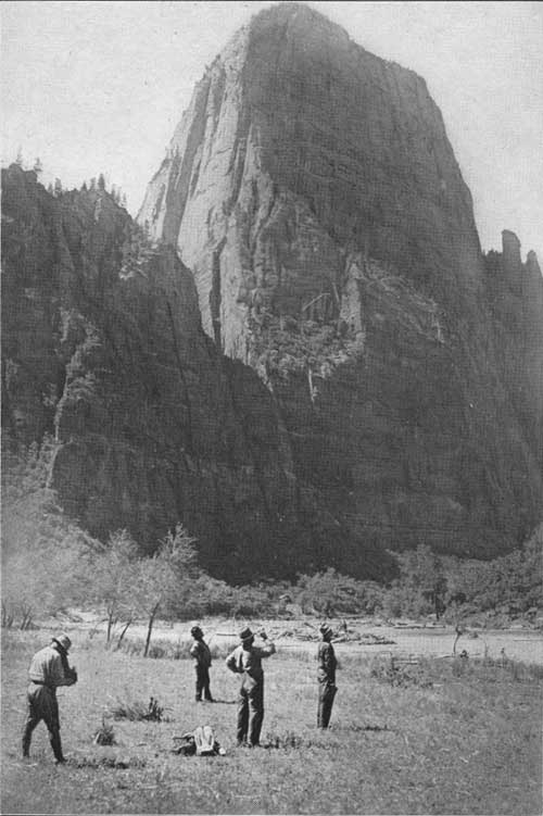
A mile above the camp stands one of the most remarkable monoliths of the region. El Gobernador is a colossal truncated dome, red below and white above. The white crown is heavily marked in two directions, suggesting the web and woof of drapery. Directly opposite, a lesser monolith, nevertheless gigantic, is suggestively if sentimentally called Angel's Landing. A natural bridge which is still in Nature's workshop is one of the interesting spectacles of this vicinity. Its splendid arch is fully formed, but the wall against which it rests its full length remains, broken through in one spot only. How many thousands or hundreds of thousands of years will be required to wipe away the wall and leave the bridge complete is for those to guess who will.
Here also is the valley end of a wire cable which passes upward twenty-five hundred feet to cross a break in the wall to a forest on the mesa's top. Lumber is Dixie's most hardly furnished need. For years sawn timbers have been cabled down into the valley and carted to the villages of the Virgin River.
In some respects the most fascinating part of Little Zion is still beyond. A mile above El Gobernador the river swings sharply west and doubles on itself. Raspberry Bend is far nobler than its name implies, and the Great Organ which the river here encircles exacts no imaginative effort. Beyond this the canyon narrows rapidly. The road has long since stopped, and soon the trail stops. Presently the river, now a shrunken stream, concealing occasional quicksands, offers the only footing. The walls are no less lofty, no less richly colored, and the weary traveller works his difficult way forward.
There will come a time if he persists when he may stand at the bottom of a chasm more than two thousand feet deep and, nearly touching the walls on either side, look up and see no sky.
"At the water's edge the walls are perpendicular," writes Doctor G. K. Gilbert, of the U. S. Geological Survey, who first described it, "but in the deeper parts they open out toward the top. As we entered and found our outlook of sky contracted—as we had never before seen it between canyon cliffs—I measured the aperture above, and found it thirty-five degrees. We had thought this a minimum, but soon discovered our error. Nearer and nearer the walls approached, and our strip of blue narrowed down to twenty degrees, then ten, and at last was even intercepted by the overhanging rocks. There was, perhaps, no point from which, neither forward nor backward, could we discover a patch of sky, but many times our upward view was completely cut off by the interlocking of the walls, which, remaining nearly parallel to each other, warped in and out as they ascended."
|
|
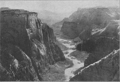
ZION CANYON FROM THE RIM From a photograph by the U. S. Geological Survey |
|
|
THE THREE PATRIARCHS, ZION CANYON These red-and-white structures rise more than two thousand feet above the canyon floor |
Here he surprises the secret of the making of Zion.
"As a monument of denudation, this chasm is an example of downward erosion by sand-bearing water. The principle on which the cutting depends is almost identical with that of the marble saw, but the sand grains, instead of being embedded in rigid iron, are carried by a flexible stream of water. By gravity they have been held against the bottom of the cut, so that they should make it vertical, but the current has carried them, in places, against one side or the other, and so far modified the influence of gravity that the cut undulates somewhat in its vertical section, as well as in its horizontal."
This, then, is how Nature began, on the original surface of the plateau, perhaps with the output of a spring shower, to dig this whole mighty spectacle for our enjoyment to-day. We may go further. We may imagine the beginning of the titanic process that dug the millions of millions of chasms, big and little, contributing to the mighty Colorado, that dug the Grand Canyon itself, that reduced to the glorified thing it now is the enormous plateau of our great southwest, which would have been many thousands of feet higher than the highest pinnacle of Little Zion had not erosion more than counteracted the uplifting of the plateau.
Little else need be said to complete this picture. The rains and melting snows of early spring produce mesa-top torrents which pour into the valley and hasten for a period the processes of decorating the walls and levelling the plateau. So it happens that waterfalls of power and beauty then enrich this wondrous spectacle. But this added beauty is not for the tourist, who may come in comfort only after its disappearance.
But springs are many. Trickling from various levels in the walls, they develop new tributary gorges. Gushing from the foundations, they create alcoves and grottos which are in sharp contrast with their desert environment, enriching by dampness the colors of the sandstone and decorating these refreshment-places with trailing ferns and flowering growths. In these we see the origin of the Indian name, Mukuntuweap, Land of the Springs.
The Indians, however, always stood in awe of Little Zion. They entered it, but feared the night.
In 1918 President Wilson changed the name from Mukuntuweap to Zion. At the same time he greatly enlarged the reservation. Zion National Monument now includes a large area of great and varied desert magnificence, including the sources and canyons of two other streams besides Mukuntuweap.
| <<< Previous | <<< Contents>>> | Next >>> |
yard3/chap17.htm
Last Updated: 30-Oct-2009