|
Alaska Subsistence
A National Park Service Management History |

|
Chapter 4:
THE ALASKA LANDS QUESTION, 1971-1980 (continued)
C. NPS Planners Consider the Subsistence Question
Driven by the promise of vast new additions to its system, [27] National Park Service leaders in the wake of ANCSA's passage began their planning effort, hoping in the process to maximize the number of acres in new or expanded park units—provided, of course, that the resources included in those areas were of sufficient caliber to warrant NPS designation. Subsistence values were a secondary consideration. Agency planners, recognizing ANCSA's generous land conveyance provisions, took care to avoid including village sites in the various proposed park units. Beyond that consideration, however, they had no compunction about including subsistence use areas within the various proposed units. Never, either at this early stage or at any other time in the proposal process, did any NPS official propose redrawing proposed boundary lines in order to exclude subsistence users. As historian Frank Williss has noted, the NPS's new approach—of preserving large ecosystems as a primary goal rather than providing for recreational and developmental needs within the parks—was one witnessed, to some extent, throughout the National Park System. Because of the acreages involved, however, the tilt toward preservation (combined, simultaneously, with a concern for the protection of traditional land uses) was more pronounced in Alaska than elsewhere. [28]
At the time of ANCSA's passage, subsistence activities had been taking place throughout Alaska for hundreds if not thousands of years. Urban as well as rural residents harvested subsistence resources; both Natives and non-Natives participated in a subsistence lifestyle. Some depended on subsistence resources more than others; a subsistence-based lifestyle remained healthy and strong in many areas, while in several areas subsistence activities were becoming less important. [29] But NPS planners, along with other federal officials, were only vaguely cognizant of these and other essential facts about Alaska's subsistence lifestyle. (The initial definition of subsistence, according to one early planner, was "timber and game for local use.") [30] NPS officials, as a consequence, commenced the park proposal process relying more on preconception and supposition than on hard, verifiable data. It is not surprising, therefore, that the agency's initial subsistence-related proposals were dramatically transformed during the planning process that preceded the passage of Alaska lands legislation.
The NPS made its first public utterance about subsistence activities in the proposed parks in July 1972, when it issued a short report documenting values and issues related to its various proposed units (as listed in the March 1972 preliminary withdrawals). This report, which paved the way for the revised recommendations that Secretary Morton issued two months later, expressly condoned the legitimacy of the Alaska Native cultures when it stated that
Nowhere else in America are the landscapes and life communities so directly and obviously involved with the cultural heritage of the people. In its growing involvement with cultural themes, the National Park Service would expect to work closely and successfully with the Alaskan natives to ensure that new parks in Alaska are not only expressive of a national land ethic but also of the cultural heritage of these Alaskans. [31]
|
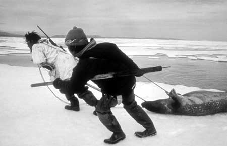
| Inupiat hunters hauling a seal kill just offshore from the proposed Cape Krusenstern National Monument during the summer of 1974. NPS (ATF Box 13), photo 4465-20, by Robert Belous |
The report was less specific about overtly condoning the legitimacy of subsistence uses. It did, however, briefly describe subsistence activities (including harvesting areas and species hunted) for the various proposed park units. Seen from a historical perspective, the report's approach to subsistence appears unpolished—there are several references to "subsistency" hunting and fishing—but because virtually no subsistence data existed that pertained to the national interest lands, the newly-obtained information proved highly valuable. [32] Significantly, subsistence uses as described in the report seem to apply only to Alaska Natives. One shortcoming of the report was its failure to mention any human uses in the proposed Aniakchak Crater unit. (This omission was corrected in subsequent reports.) In addition, the report noted that in the proposed Katmai extension, "many of [the] animals [in the proposed unit] have never been hunted by man and know little fear of him;" and regarding the proposed Kenai Fjords unit, the report noted that human use "tends to be extremely light, with fishermen being the most numerous public intruders." These notes, brief as they were, may have set a precedent because the Alaska Lands Act, as passed in 1980, did not authorize subsistence activities either in Kenai Fjords National Park or in the newly-expanded portions of Katmai National Park. [33]
Shortly after the release of the July 1972 park proposal document, state and federal authorities settled a legal matter in a way that had far-reaching ramifications on the future of Alaska subsistence. The conflict was over land claims. The previous January, the State of Alaska—which had been unable to file any claims during the years preceding ANCSA's passage—had filed for 77,000,000 acres under the Statehood Act. Two months later, however, confrontation arose when Interior Secretary Morton made his initial 80,000,000-acre national interest lands withdrawal. A month later, the state sued over the legality of some 42,000,000 acres that had been claimed by both governments. The land-claims conflict, if allowed to fester, threatened to derail the national interest lands planning process, but on September 2, the state announced that it had agreed to drop its lawsuit and its claim to the contested acreage. In return for that action, however, the state was allowed to select large blocks of national interest lands that had been part of the Gates of the Arctic and Mount McKinley park proposals. In addition, the state extracted a crucial concession: that some 124,000 acres of land in the Aniakchak Crater proposal area would be open to sport hunting. [34] Before long, NPS and Congressional authorities recognized that lands in other proposed park units also needed to provide for sport hunting; and as noted below, Congressional approval of the first two NPS-administered "national preserves" in October 1974 created a classification under which sport hunting could be authorized. The September 2, 1972 agreement, in short, proved to be the wedge that, years later, resulted in 19,000,000 acres of national preserves in Alaska.
Between September 1972 and December 1973, as noted above, a primary purpose of the NPS's Alaska Task Force was the further investigation of the various proposed park units, and the fruits of that investigation were encapsulated in various master plans and draft environmental impact statements (DEISs). To a large extent, the NPS forged its subsistence policy during that time. (Most of this was ad hoc policymaking, although Bob Belous of the NPS, in November 1973, completed an interim report on subsistence use in the proposed parklands at the behest of Assistant NPS Director Ted Swem and Alaska Task Force Director Al Henson. [35]) Most if not all of the documents produced in December 1973 included a separate section discussing subsistence, and the subsistence recommendations emanating from these documents are a logical outcome of those discussions.
Most of these recommendations were surprisingly consistent with one another. In statements that presaged the possibilities for both cultural change and ecological degradation, the various DEISs and master plans typically made the following recommendation:
Except as may otherwise be prohibited by law, existing traditional subsistence uses of renewable resources will be permitted until it is demonstrated that these uses are no longer necessary for human survival. If the subsistence use of a resource demonstrates that continued subsistence uses may result in a progressive reduction of animal or plant resources which could lead to long range alterations of ecosystems, the managing agency, following consultation with communities and affected individuals, shall have the authority to restrict subsistence activities in part or all of the park. [36]
|
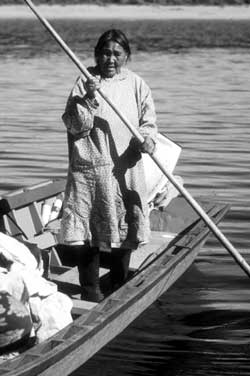
| Inupiat woman poling a boat in northwestern Alaska, 1974. NPS photo by Robert Belous |
In a notable departure from the implications suggested in the July 1972 document, all of the units proposed to be added to the National Park System, including Kenai Fjords and the Katmai extension, included provisions for subsistence within their DEISs. Another notable change was that race was no longer a factor in determining subsistence eligibility. [37] But clouding the picture was the fact that many subsistence users would be competing with others for the available resources. This was because the proposals for six of the nine new NPS areas—Aniakchak Caldera, Chukchi-Imuruk, Gates of the Arctic, Lake Clark, Wrangell-St. Elias, and Yukon-Charley—allowed sport hunting to continue. This state of affairs was doubtless spurred by pressure from hunting groups and was a logical outgrowth of the September 1972 decision that had ensured the continuation of sport hunting in portions of the Aniakchak proposal. [38]
Particular attention was paid to subsistence at five of the proposed parks. In the Wrangell-St. Elias National Park proposal document, an extended discussion on the subject detailed differences between subsistence and sport harvests, and it also included several harvest tables that had been prepared by a resource management team from the Joint Federal-State Land Use Planning Commission. [39] At Kobuk Valley, a primary purpose of the NPS proposal was "to foster the continuation of the Alaska Eskimo culture by providing for traditional resources uses, such as hunting, fishing, and gathering, provided such uses are consistent with the preservation of primary resource values." To accomplish that goal, the agency proposed that the monument be closed to sport hunting, and perhaps to justify the proposed hunting ban, the draft EIS provided an extensive discussion of the Eskimos' strong dependence on subsistence harvests for their food intake. [40] Noatak, similar to Kobuk Valley, was singled out as an area where subsistence activities were a central aspect of the proposal. Stating that "the Noatak Valley represents the largest undeveloped and pristine river valley in the United States ... best characterized as a vast primitive expanse by virtue of low human numbers, scant development, outstanding scenery, and concentrations of wildlife," the draft EIS concluded that the Noatak and adjacent Squirrel River basins were "of significant value as natural, undisturbed laboratories," in large part because "such areas are practically nonexistent in the conterminous United States, and are becoming increasingly rare worldwide." Based on that premise, a primary purpose of the so-called Noatak National Ecological Range—to be jointly managed by the Bureau of Land Management and the Bureau of Sport Fisheries and Wildlife—was "to continue to make available renewable natural resources for subsistence uses, and to protect and conserve these resources for all Americans." As with the Kobuk Valley proposal, the Noatak document provided extensive data to demonstrate area residents' dependence on locally available fish, game, and other food sources. [41] A fourth proposal in which subsistence values were emphasized was the Chukchi-Imuruk National Wildlands document. A primary purpose of this unit, which was to be co-managed by the the NPS and the Bureau of Sport Fisheries and Wildlife, was the "interpretation of the ecological, geological, cultural, and scenic features and processes of the area, with emphasis on developing understanding and respect for an alternative cultural system as exemplified by the present day American Eskimo culture." [42]
A final proposal in which extensive attention was paid to subsistence lifeways and resources was at Gates of the Arctic. Of particular interest at the proposed park were the Nunamiut people—so-called mountain Eskimos—who resided at Anaktuvuk Pass. As historian Ted Catton has explained in remarkable detail, these villagers were historically anomalous to other northern Alaskan residents in that they were inland, nomadic people whose diet and lifestyle revolved around caribou and their migrations. By 1900, however, most of the Nunamiut had moved to the Arctic coast, and by 1920 the mountains were probably entirely deserted. (So-called "push factors"—namely, a crash in the caribou population—were the primary cause of the migration, but the "pull factors" of whaling ships, trading posts, and mission schools along the Arctic coast may have also played a role.) During their tenure along the coast many Nunamiut learned English, adopted Christianity, and absorbed other aspects of American culture. But the lure of the mountains (and a rebound in the caribou population) caused the group to migrate seasonally away from the coast, and after 1939 they gave up traveling to the coast altogether. In 1943, a Nunamiut group was "discovered" by pilot Sigurd Wien at the north end of Chandler Lake; two years later, a USGS surveyor witnessed a Nunamiut caribou hunt. [43]
In 1949, the Nunamiut—five families from Chandler Lake, followed by eight families from the Killik River—moved to a plateau at the headwaters of the John River and founded the village of Anaktuvuk Pass; before long a school, airstrip, and church were established at the site. [44] The Nunamiut, like other Native peoples, welcomed these and other trappings of modern civilization. Non-Natives who encountered them, however, were mesmerized by the more traditional aspects of culture that they represented. Located in the isolated wilderness of northern Alaska, and carrying on many traditions that had remained unchanged for hundreds of years, those who visited—and wrote about—the Nunamiut identified this so-called "lost tribe" as being uniquely "ancient," "Stone Age," and "timeless." This distinction, whether it was accurate or not, was shared by anthropologists, government planners, and other observers, and it fit neatly into the widely-held notion—largely promulgated by conservationist Robert Marshall—that the central Brooks Range was the "ultimate" or "last great wilderness." [45] A series of anthropologists, drawn to Anaktuvuk Pass, were so enamored by what they saw that they encouraged the Nunamiut to value their primitiveness. The villagers responded to these visits amicably enough; even so, they marched ahead and—to the dismay of many—acquired new technology as the occasion demanded. By doing so, they lost much of their charm in the perception of non-Natives, many of whom were ardent wilderness enthusiasts. The Nunamiut, sensitive to these changing attitudes, soon began to feel that they were being treated as intruders in their own homeland. [46]
It was in the midst of this process—in which outsiders' admiration of the Nunamiut's traditional lifestyle was being tempered by the invasion of new technology—that the NPS began considering a parkland in the central Brooks Range. The agency, at the behest of Interior Secretary Stewart Udall, had first considered the area as a park unit back in 1962, when he had sponsored the visitation of a film crew to the Arrigetch Peaks area. Political sensitivities forced Udall to leave that film footage on the proverbial cutting room floor, and the park idea was shelved for the time being. [47] Then, in June 1968, an NPS team again reconnoitered the area. (During that visit, planner Merrill Mattes acidly noted that Anaktuvuk Pass was "not exactly Shangri-La.") The report resulting from that visit recommended a 4.1 million-acre, two-unit Gates of the Arctic National Park; the two units of that park, perhaps in deference to the Nunamiut presence, were drawn well away from Anaktuvuk Pass and the John River valley. That park proposal, along with proposals pertaining to Mount McKinley National Park, Katmai National Monument and four non-Alaska park areas, were forwarded to Interior Secretary Stewart Udall in a package that became known as "Project P." This package, which was forwarded to President Lyndon Johnson in January 1969—in the last few days before Richard Nixon was inaugurated—proved controversial. As a result—and several reasons have been speculated behind his action—Johnson signed proclamations pertaining to only three of the seven park proposals. Of the Alaska proposals, Johnson agreed to sign only the Katmai expansion proclamation; left unsigned were proclamations to create Gates of the Arctic National Monument, along with a proposed 2.2 million-acre expansion to Mount McKinley National Park. [48]
No sooner had the monument proposal been rejected than progress—in the form of a winter haul road—thrust its way up the John River Valley and through Anaktuvuk Pass. The road, dubbed the "Hickel Highway," was carved out during the midwinter months of 1968-69, and for six weeks after its completion large trucks roared through the village. A similar scenario repeated itself for a few weeks the following winter. [49] Then, in December 1971, came ANCSA's passage, and with it came the legal right for newly organized regional and village corporations to select land in and around Anaktuvuk Pass. [50]
It was in the atmosphere of these changes that the NPS resurrected its Gates of the Arctic park proposal. At first, NPS planners (who were hired in May 1972) paid little attention to the area's Native populations. The July 1972 proposal boundaries, for example, stayed more than 12 miles away from Anaktuvuk Pass, and the brief report on the park proposal merely noted that "caribou and moose are hunted mainly for subsistence by local people, many of whom depend upon the game for most of their food." [51]
Shortly after the issuance of that report, Native interests began to recognize that the National Park Service might well be an ally in their cause. Anticipating (or perhaps hoping) that the NPS would protect their subsistence resources, the Nunamiut Corporation (the newly-established village corporation for Anaktuvuk Pass) and the Arctic Slope Regional Corporation (the regional corporation encompassing the village) began to entertain the idea of a permanent dual-ownership arrangement. Sensing common ground with the NPS, Native officials formalized this idea on April 23, 1973, when ASRC's president testified before the Joint Federal-State Land Use Planning Commission that the Inupiat Eskimos were in favor of a Nunamiut National Park that would be cooperatively managed by the NPS and the Eskimos. This bold action was the first proposal of its kind in Alaska. [52]
|
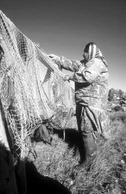
| Drying fish nets near Ambler, September 1974. NPS (ATF Box 10), photo 4765-7, by Robert Belous |
In response to the ASRC proposal, NPS planner John Kauffmann began discussing with the Nunamiut just how such a park plan might jibe with the agency's own proposals. What emerged from those discussions was a proposal, issued in December 1973, for a tripartite park unit. The eastern and western thirds of the central Brooks Range would be designated the Gates of the Arctic Wilderness Park; in this 7,130,000 acre area, which the NPS would manage, subsistence hunting by Natives would be permitted, but non-Native sportsmen would be limited to "fair-chase hunting." (The fair-chase concept, hearkening back to the methods practiced by elite sportsmen decades earlier, suggested a minimum ten-day stay in the wilderness and a lack of dependence on radio and other communications.) Sandwiched between the two units of the wilderness park, an area called the Nunamiut National Wildlands was proposed. In that 2,390,000-acre expanse, which included Anaktuvuk Pass and adjacent areas, management would be largely similar to that of the wilderness park. In the wildlands, however, subsistence hunting would take priority over sport hunting, and the NPS, the Nunamiut Corporation, and the ASRC would cooperatively manage the area. Ironically, the continuation of subsistence activities was not an expressly stated purpose of either the wilderness park or the wildlands proposal; instead, the wildlands proposal was more generic. It stated that a primary purpose would be "to assure that the outstanding cultural, natural, and recreational resources in the area are managed in a manner which will perpetuate the resource values for public use and benefit." [53]
The NPS, at both the local and national levels, and the various Native parties were all in full agreement with the proposal as outlined above. But the Federal government's Office of Management and Budget (OMB) was not. On December 16, 1973—just one day before the Interior Secretary's deadline to forward this and the other park proposals to Congress—the OMB rejected the National Wildlands concept, which was to have been applied to both the Nunamiut and Chukchi-Imuruk proposals. As noted in an errata sheet that was stapled to the front of each draft EIS, the OMB explained that the national park system should not be encumbered with new area designations. Much to the chagrin of Interior Department officials, the OMB refused to countenance proposals in which the NPS shared its management authority with non-Federal parties (in the Nunamiut case) or with other Federal agencies (in the Chukchi-Imuruk case). In the Nunamiut case, OMB was willing to allow a cooperative agreement issued by the Interior Secretary allowing a Native corporation "mutually compatible administration" of park lands; in the Chukchi-Imuruk case, Interior Department officials reacted to OMB's dictum by declaring that the NPS would administer the area. [54]
As noted above, the period between September 1972 and December 1973 witnessed a huge increase of NPS knowledge about land use activities on lands being proposed for inclusion in park units, and the issuance of the various DEISs in December 1973 reflected the agency's increasing sophistication toward subsistence matters. The various DEISs, by proposing the continuation of subsistence activities in all of the proposed park units, clearly showed that the NPS was sensitive to the needs of both Native and non-Native subsistence users. (See Table 4-3, opposite page.) The Federal government, moreover, openly advocated subsistence as a core value in two proposed park units (Kobuk Valley and Noatak [55]), and in the Gates of the Arctic proposal, the NPS supported a unit—the Nunamiut National Wildlands—that would be jointly managed with two Native corporations. The OMB's rejection of the latter proposal tempered the agency's future actions toward that park proposal, but it in no way diminished the agency's philosophical attitudes toward the value of subsistence in that area. The NPS, quite apparently, had a special recognition toward subsistence values in the proposed northern-tier parks: Gates of the Arctic, Noatak, Kobuk Valley, Cape Krusenstern, and Chukchi-Imuruk. As former employee Bob Belous noted, the agency had no intention of downplaying the significance of subsistence activities in the other proposed park areas. Subsistence in the northern tier parks, however, "was more susceptible to publicity," and the photographs and descriptions that emanated from the various NPS proposal documents for these park units often highlighted Natives, Native harvesting, and Native craft items. [56]
Table 4-3. Subsistence Eligibility in the Proposed Alaska Parklands, 1973-1980
| Proposed Park Unit |
12/73 DEIS | 1/75 FES | 10/77a HR 39 |
10/77b HR 39 | 2/78 HR 39 | 5/78 HR 39 |
10/78 S 9 | 12/78 Proc. | 1/79 HR 39 |
5/79 HR 39 | 10/79 S 9 | 12/80 Law |
| Aniakchak | Y | Y | N | N | Y | Y | N | Y | Y | Y | N | Y(t) |
| Bering Land Bridge | Y* | Y | Y | Y | Y | Y | (Y) | Y | Y | Y | (Y) | (Y) |
| Cape Krusenstern | Y | Y | Y | Y | Y | Y | Y | Y | Y | Y | Y | Y |
| Gates of the Arctic | Y* | Y | N | Y | Y | Y | Y(t) | Y | Y | Y | Y(t) | Y(t) |
| Kenai Fjords | Y | Y | N | Y | Y | Y | N | N | N | N | N | N |
| Kobuk Valle | Y* | Y | Y | Y | Y | Y | Y | Y | Y | Y | Y | Y |
| Lake Clark | Y | Y | N | Y | Y | Y | N | Y | Y | Y | N | Y(t) |
| Noatak | Y* | Y | N | Y | Y | Y | (Y) | Y | Y | Y | (Y) | (Y) |
| Wrangell-St. Elias | Y* | Y | N | Y | Y | Y | N | Y | Y | Y | N | Y(t) |
| Yukon-Charley R's | Y | Y | N | Y | Y | Y | (Y) | Y | Y | Y | (Y) | (Y) |
| Denali Additions | Y | Y | N | Y! | Y | Y | N | Y | Y | Y | N | Y(t) |
| Glacier Bay Add'ns | Y | Y | N | Y | Y | Y | N | Y | Y | Y | N | N |
| Katmai Additions | Y | Y | N | Y | Y | Y | N | Y | Y | Y | N | N |
| Alagnak Wild. R.@ | -- | -- | N | N | Y | Y | Y | -- | Y | Y | Y | Y |
Note: The above chart covers subsistence uses on proposed new lands only. Several of the units noted above, at various times during the proposal process, had both parks (or monuments) and preserves. In those cases, the above use decisions pertain only to the proposed parks or monuments; in all of the adjacent preserves, subsistence uses are allowed. The names given for the proposed park units are those in the final (Dec. 1980) bill; other names, as noted elsewhere, were often used in the various environmental statements or draft legislative bills.
Document Identification:
DEIS = Draft
Environmental Impact Statement; FES = Final Environmental Statement; HR
39 = House Bill 39; 10/77a = 10/12/77 Committee Print #1; 10/77b =
10/28/77 Committee Print #2; S 9 = Senate Bill 9, Proc. = Presidential
Proclamation; Law = Alaska National Interest Lands Conservation Act,
signed 12/2/80.
Symbols on Chart:
Y = subsistence is sanctioned
N = subsistence is prohibited
Y(t) = subsistence is sanctioned "where such uses are traditional"
Y* = subsistence is sanctioned, and additional measures are proposed to
protect subsistence values
Y = subsistence is a purpose of the proposed parkland
Y = "protecting the viability of subsistence resources" is a
purpose of the proposed parkland
(Y) = subsistence is sanctioned by virtue of its status as a proposed
national preserve
Y! = subsistence is sanctioned only on the proposed North Addition
@ = Alagnak Wild River was in an "area of environmental concern" near
the proposed Katmai National Park in 1973 and 1975. In the 95th
Congress, the House continued to treat the Alagnak as part of a proposed
Katmai addition. But S 9, in Oct. 1978, gave it separate treatment,
and bills in the 96th Congress did the same.
| <<< Previous | <<< Contents >>> | Next >>> |
alaska_subsistence/chap4b.htm
Last Updated: 14-Mar-2003