

|
SHENANDOAH National Park |
 |
The Last Billion Years
From Hogback Overlook, highest in the north section of the park, you can see to the heart of the Appalachians. As your gaze travels westward, it first falls on the South Fork of the Shenandoah River, winding far below in its valley. Beyond, the two ridges of the Massanutten Mountains rise, hiding the Shenandoah's North Fork on their far side. Still farther westward, two or three ridges of the main Appalachian body fade away into the blue haze of West Virginia. This soul-lifting scene has the look of eternity about it, giving a feeling of peace and stability. But from an earth-time point of view, even these mountains illustrate that change is the norm, for the main features of the view from Hogback probably have existed for less than one-twentieth of earth's history.
To learn what happened here before the Blue Ridge and its westward companions were formed, we must look at the rocks. Just south of Thornton Gap, at Marys Rock Tunnel, Skyline Drive goes through granodiorite at least 1.1 billion years old. This is part of the ancient granitic rock which forms the core of the Blue Ridge. Though exposed now, this rock was formed miles below the surface under tremendous heat and pressure.
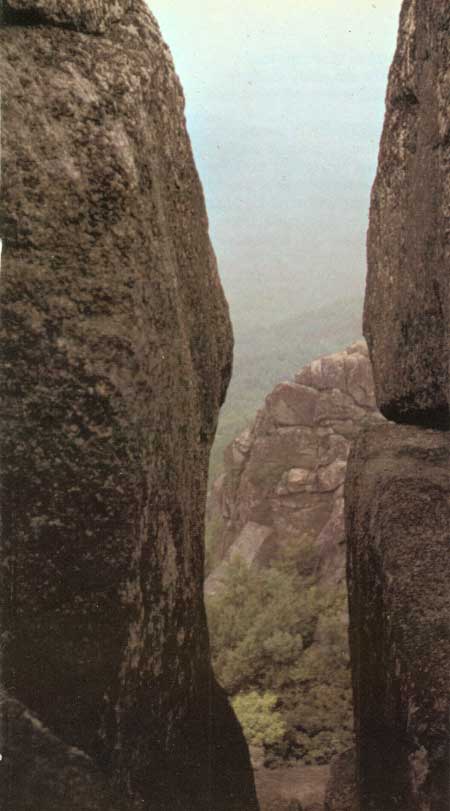
(Photo by Ross Chapple)
The earliest landscape that can be reconstructed from present geologic evidence was carved in these granitic rocks after their overburden was eroded away. Wind and rain sculptured them into an irregular pattern of hills and valleys, the hills rising as much as a thousand feet. It was a bleak scene, lifeless except possibly for a few algae clinging to the rocks.
This scene was dramatically transformed some 800 million years ago by a series of lava flows, which poured out of long cracks, or fissures, in the granite and gradually filled the valleys. (Greenstone dikes in the older rock at Marys Rock Tunnel and on Old Rag represent two of these fissures.) Eventually even the hilltops were buried under these fiery flows, producing a broad plateau in place of the former hilly landscape. How deep this lava was we can only conjecture, for its upper layers have been eroded from the Blue Ridge. In the Big Meadows-Stony Man area 12 flows, with a total thickness of 1800 feet, have been detected. The accumulated lava flows may originally have been several times as thick.
Today, remnants of these lava flows form many of the cliffs in the park, most notably Franklin Cliffs near Big Meadows and the cliffs on the west side of Stony Man. Most of the park's waterfalls occur where streams plunge over ledges of this rock. (The new mineral composition of the rock gives it a distinctive green color, hence its name—greenstone.) The original volcanic nature of the rock is not now obvious because it was changed subsequently by heat and pressure due to burial deep within the earth; but traces of the gas bubbles that formed in the hot lava, and vertical columnar joints that formed when the lava cooled and cracked can still be seen.
The crust of the earth is more flexible than we might imagine, and when subjected to pressure it moves. After a long existence, the plateau was subjected to some great force which slowly depressed it beneath a rising sea. And perhaps it was those same pressures that formed the mountains, now gone, which rose along the eastern edge of our continent. Whatever the causes, the present Appalachian area became a long trough filled by an arm of the ocean. Into this shallow trough washed sediments from the uplands. For many millions of years, long enough for life to evolve from simple soft-bodied sea animals to bony fish and finally to the great experiment of land-dwelling amphibians, the deposition went on. Though the shorelines of the sea fluctuated, the long-term trend was toward shrinkage, so that much of the eroded material never reached the sea but was deposited in streambeds and over the land by floods. In the later stages of the Appalachian trough, we can imagine a rather level, perhaps swampy area lying west of the present Blue Ridge. Ferns and canelike horsetails spring from the ground. Here and there strange, scaly trees rise above them. Near pools presided over by giant dragonflies, descendants of lobe-finned fishes drag themselves through the vegetation.
Although some 30,000 feet of sediments were deposited in that great depression during the 350 million years of the Paleozoic Era, only the lowest (oldest) part of it remains today on the Blue Ridge. These sedimentary remnants consist of white, gray, or purple quartzites (made from sandstone) and interbedded shales (made from mud), which are exposed chiefly in the south and north sections of the park. The only evidence of life preserved in these rocks is the long, tubelike structures called Scolithus, presumed to be the burrows of worms that tunneled into the sandy sea floor long before it was compressed into rock.
The great swamps of the Appalachian trough, in which were entombed the plants that we mine as coal, were destined to be erased forever by that profound geologic event known as the Appalachian Revolution. Some 200 million years ago, pressures from the southeast gradually folded and sometimes buckled those thousands of feet of sediment, forming the Appalachian Mountains. Depending on the rates of uplift and erosion, these mountains in their early days may have looked like the Alps or may have appeared much as they do today.
Take a 50-million-year step now, to the period called the Jurassic, and what do we see? The west slopes of our ancestral Blue Ridge face other peaks; but eastward the mountains diminish to a lowland along the coast. Encouraged by a warm climate (the norm for most of earth's history), ferns, palmlike cycads, and conifers not greatly different from our present ones dot the landscape. A carnivorous dinosaur, running on its big hind legs, emerges from the trees in pursuit of one of its lesser brethren. Insects make their shrill music. To us it is still an alien scene.
Jump another 125 million years, to the Miocene, and we feel more at home. The mountains now have a cover of forest trees very much like our present ones. Walking the Blue Ridge slopes, we find maples, oaks, ashes, hickories, chestnuts, beeches, and walnuts—not the same species as today, but quite recognizable. At our approach, a three-toed horse quits its browsing to run, and a large bearlike dog slinks into the forest. The rise of mammals has followed the development of deciduous trees, which in turn has followed a cooling trend—a trend that will reach a climax in the Pleistocene, or ice age.
Geology of the Blue Ridge
 |
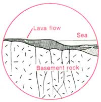 |
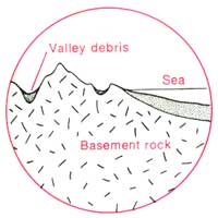
| The oldest exposed rocks in the Blue Ridge are granites and gneisses more than a billion years old. Long after these were formed deep within the earth, they were uplifted and laid bare by erosion. Further erosion carved deep into these "basement rocks". Much of the debris was deposited in the shallow sea that lay to the east of what is now the Blue Ridge. | Much later, molten basalt welled up through cracks in the basement rock and flowed across the landscape. By the time this volcanic outpouring ceased, it had created a vast, featureless lava plain. |
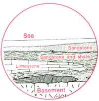 | |
| About 600 million years ago the lava plain was downwarped and covered by a shallow sea. As it continued to subside, sediment accumulated on the bottom of the sea, eventually resulting in shales, limestones, sandstones, and conglomerates 30,000 feet thick. Under the weight of these rocks the lava was metamorphosed into greenstone. | |
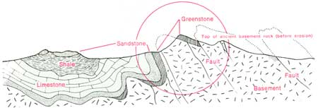 | |
| About 230 million years ago the mountain building and uplift reached a climax as the sedimentary rocks were buckled into huge folds and were lifted above sea level. Erosion attacked the softer limestone and shale, leaving a series of long, parallel ridges of sandstone and conglomerate; these rocks were eventually eroded away, exposing the greenstone and basement rocks. The Blue Ridge is the core of one of these ridges. | |
Just a tick on the geologic clock before the present, the ice age presents a Blue Ridge scene that is both familiar and unfamiliar. Scanning the ridge at the climax of the last major glaciation, about 15,000 or 20,000 years ago, we recognize the individual peaks by their contours; but the forest and its life surprise us. The edge of the massive glacier is some 200 miles north of us and the cool climate that accompanies it has mantled the highest slopes with spruce and fir. As we sit under the dark conifers crowning Stony Man, gray jays mew furtively in the boughs overhead, and a porcupine ambles from one tree base to another. Along a trail made by white-tailed deer and black bears, a cottontail rabbit hops toward us. Now we look far down the ridge and see a pack of dire wolves crossing a saddle. Descending into a hollow, they suddenly bolt as a great gray mastodon emerges from the forest. This sight climaxes a day in which we have seen some animals that today are extinct (dire wolf and mastodon), some that now are only found farther north (gray jay and porcupine), and some that still live in the Blue Ridge. The ranges of these animals remind us that Shenandoah climates of today are only a few degrees removed from those of the Pleistocene, and that another ice age could easily return.
During that immense interval between the rise of the Appalachians and the present, the infinitely slow but persistent forces of erosion have worn down the ranges to low, rounded ridges of resistant rock, and rivers such as the Shenandoah have carved deep valleys in the softer limestone and shale. These forces—wind, water, freezing, thawing, and gravity—continue their work today. Masses of gray boulders, lying still in steep ravines, may move again in the next big rainstorm. Ice collecting in a crack may chip another piece off the face of Stony Man. And every day, streams carry bushels of soil down the steep slopes.
Though the view from Hogback does not directly tell us, nature creates, and nature destroys.

|

|

| NPS History | History & Culture | National Park Service | Contact |
|
Last Modified: Sat, Nov 4 2006 10:00:00 pm PST |