

|
EVERGLADES National Park |
 |
AMERICA'S SUBTROPICAL WONDERLAND
Everglades may not be our largest national park (that honor belongs to Yellowstone, with Mount McKinley a close second) but it is certainly the wettest. During and after the rainy season, when not only the mangrove swamp but also the sawgrass prairie is under water, most of the park abounds in fish and other water life, and even the white-tailed deer leads a semi-aquatic existence.
Despite the fact that it is low, flat, and largely under water, Everglades is a park of many environments: shallow, key-dotted Florida Bay; the coastal prairie; the vast mangrove forest and its mysterious waterways; cypress swamps; the true everglades—an extensive freshwater marsh dotted with tree islands and occasional ponds; and the driest zone, the pine-and-hammock rockland.
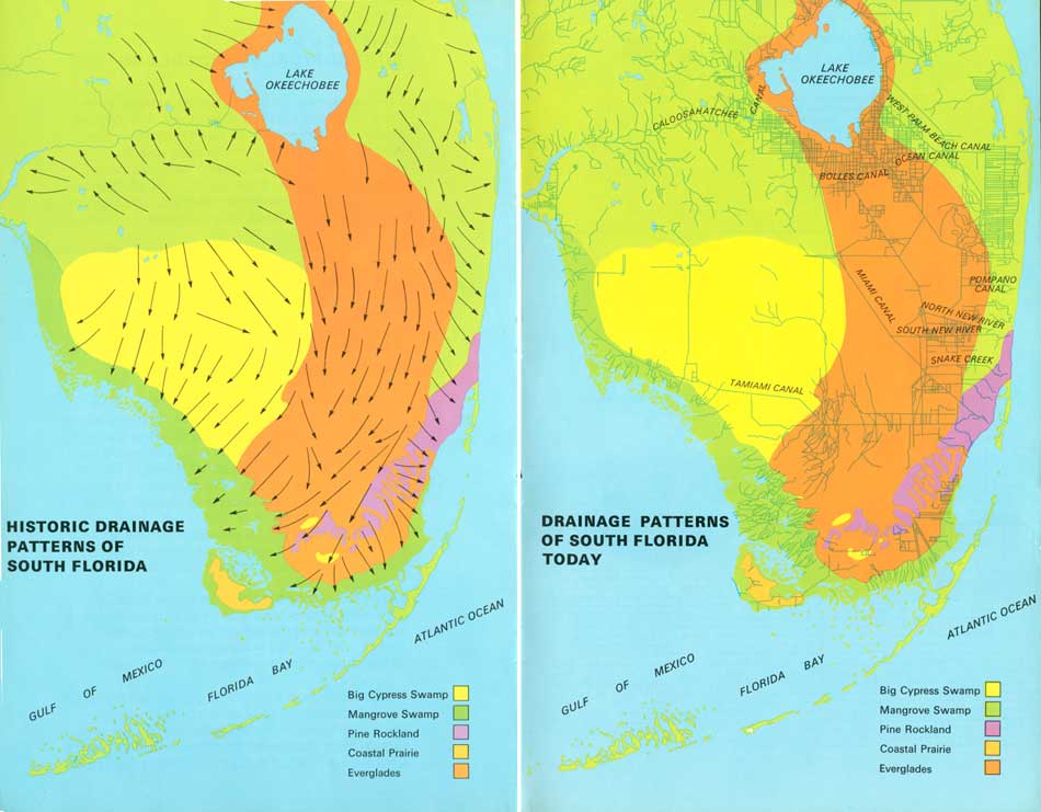
The watery expanse we call "everglades," from which the park gets its name, lies only partly within the park boundaries. Originally this river flowed, unobstructed though very slowly, southward from Lake Okeechobee more than 100 miles to Florida Bay. It is hardly recognizable as a river, for it is 50 miles wide and averages only about 6 inches deep, and it creeps rather than flows. Its source, the area around Lake Okeechobee, is only about 15 feet above sea level, and the riverbed slopes southward only 2 or 3 inches to the mile.
As you can see by the maps on pages 2 and 3, the works of man have greatly altered the drainage patterns and the natural values of south Florida, and you can imagine how this has affected the supply of water—the park's lifeblood.
 (click on image for an enlargement in a new window) |
The park's array of plants and animals is a blend of tropical species, most of which made their way across the water from the Caribbean islands, and species from the Temperate Zone, which embraces all of Florida. All of these inhabitants exist here through adaptation to the region's peculiar cycles of flood, drought, and fire and by virtue of subtle variations in temperature, altitude, and soil.
 PLANTS COMMUNITIES OF EVERGLADES NATIONAL PARK. The horizontal distance represented on this diagram, from the Pineland to Florida Bay, is 15 miles. With a greatly exaggerated vertical scale, the difference between the greatest elevation of the pine ridge and the bottom of the Florida Bay marl bed is only 14 feet. (click on image for an enlargement in a new window) |
Underlying the entire park is porous limestone (see glossary), which was deposited ages ago in warm seas that covered the southern part of today's Florida peninsula. Over this limestone only a thin mantle of marl and peat provides soil for rooting plants.
Some of the park's ecosystems (see glossary) are extremely complex. For example, a single jungle hammock of a dozen acres may contain, along with giant live oaks and other plants from the Temperate Zone, many kinds of tropical hardwood trees; a profusion of vines, mosses, ferns, orchids, and air plants; and a great variety of vertebrate and invertebrate animals, from tree snails to the white-tailed deer.
Entering the park from the northeast, you are on a road traversing the pineland-and-hammock "ridge." This elevated part of the South Florida limestone bedrock, which at the park entrance is about 6 feet above sea level, is the driest zone in the park. Pine trees, which will grow only on ground that remains above water most of the year, thrive on this rockland.

|

|

| NPS History | History & Culture | National Park Service | Contact |
|
Last Modified: Sat, Nov 4 2006 10:00:00 pm PST |