

|
SAGUARO National Park |
 |
plant and animal zones
Mountains are biologically exciting because their elevation produces, in a short vertical distance, the same climatic changes that occur over long latitudinal distances. In Arizona, average temperatures drop about 4° with each 1,000-foot rise in elevation, and precipitation increases about 4 to 5 inches. At sea level, you would have to travel about 900 miles north to experience the climatic change found in going from the lowest part of the monument (2,200 feet) to the top of Mica Mountain (8,600 feet). Plant-and-animal communities change along these climatic gradients.
In southern Arizona, the sequence of vegetation types begins with desert scrub at the lowest elevations, and ranges through desert grassland, oak woodland and chaparral, oak-pine woodland, ponderosa pine forest, and Douglas-fir forest, to Engelmann spruce forest on top of the highest mountains. In the national monument we have all these types except the last—although desert grassland is poorly represented here because the steep slopes squeeze it into a narrow altitudinal band; and Douglas-fir forest is restricted to small areas in canyons and on north-facing slopes at high elevations. A few drainageways (notably Chiminea Canyon, on the south side of the monument) support patches of deciduous trees classified as riparian woodland.
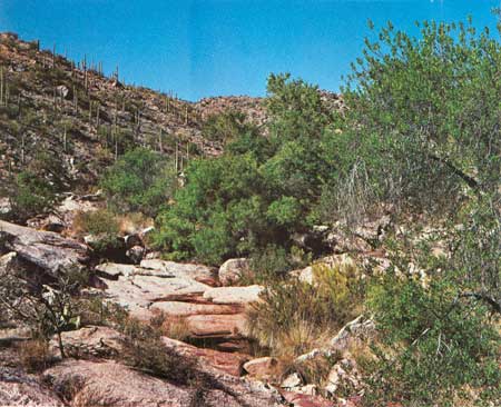 Chiminea Creek, originating in the higher elevations of the Rincon Mountains, forms a ribbonlike oasis of hydrophytic plants, including large trees such as sycamore, walnut, and cottonwood. |
These vegetation zones should not be visualized as nice neat bands on the mountainsides, however, for roughness of topography and differing tolerances of plant species usually lead to gradual changes from one zone to the next. Because of the greater exposure to drying heat and sunlight, each belt occupies a higher range of elevation on south-facing slopes than on north-facing ones. And along draws, where conditions are wetter and cooler than on ridges at the same elevations, the vegetation zones finger down to lower elevations; on ridges the opposite is true.
Animals are less restricted than plants to particular vegetation belts, but they, too, show a zonation with altitude. You must look, for instance, in the paloverde-saguaro community (part of the desert scrub type) for kangaroo rats and cactus wrens; in the oak-pine woodland for Mexican jays; and in the ponderosa pine forest for whitetail deer and tassel-eared squirrels.
In the Tucson Mountains, only the desert scrub type is well represented, although the highest ridges support a suggestion of desert grassland. A small patch of shrub live oaks, relicts of a wetter period, huddles on the north side of Wasson Peak. Zonation is poorly developed here because the mountains are low and small in mass. (Studies have shown that mountains of smaller mass tend to have warmer and drier climates than bulkier mountains of the same height.)
Major Vegetation Types in Saguaro National Monument
| Vegetation type |
Average July temp. |
Elevations (feet) |
Annual rainfall (inches) |
Prominent species |
Life zone |
| Southwestern Desert Scrub | 94 | 2,200 to 4,000 | 7 to 13 | Paloverde Saguaro Pricklypear Cholla Catclaw Ocotillo Creosotebush Mesquite Ironwood* |
Lower Sonoran |
| Grassland Transition | 85 | 3,500 to 4,500 | 10 to 15 | Mesquite Beargrass Gramagrasses Amole Sotol |
Upper Sonoran |
| Oak-pine-juniper Woodland and Chaparral | 74 | 4,500 to 7,000 | 12 to 22 | Emory Oak Mexican Blue Oak Shrub Live Oak Pinyon Pine Mountain-mahogany Manzanita Skunkbush |
Upper Sonoran |
| Coniferous Forest | 68 | above 6,000 | 18 to 30 | Ponderosa Pine Gambel Oak Buckbrush Mountain Muhly Douglas-fir White Fir Aspen Snowberry Mexican White Pine |
Transition and start of Canadian |
| *TUCSON MOUNTAIN SECTION | |||||
Biologists have developed several systems for classifying assemblages of plants and animals over broad regions, and one of the most widely known is that of C. Hart Merriam. Around the turn of the century, he conceived a system of "life zones," named for the parts of the continent where they are best developed: Tropical, Lower Sonoran, Upper Sonoran, Transition, Canadian, Hudsonian, and Arctic. In Saguaro National Monument, the Lower Sonoran Zone corresponds to the desert scrub type; the Upper Sonoran includes desert grassland transition, oak woodland, and oak-pine woodland; the Transition Zone is equivalent to the ponderosa pine forest; and the poorly represented Canadian Zone has Douglas-fir and white fir. Because Merriam's system is so widely used, his terms are included in the tabulation on page 20, which summarizes the main characteristics of plant zones in the monument.
The best way to appreciate the biotic changes that occur with elevation is to walk or ride a horse to the top of the Rincons. But if your time or energy is limited you can get a quick view of these sequences by driving up nearby Mount Lemmon, in the Santa Catalina Mountains.

|

|

| NPS History | History & Culture | National Park Service | Contact |
|
Last Modified: Sat, Nov 4 2006 10:00:00 pm PST |