

|
ROCKY MOUNTAIN National Park |
 |
What To Do
Viewing the scenic splendors of Rocky Mountain National Park has the greatest appeal for most of the people visiting the area. Several auto drives are available, and miles of trail for foot or horseback travel beckon the visitor. A few of the principal automobile and trail trips are described on pages 57 to 66.
The free ranger-naturalist programs are popular. Many people fish in the park (a State license is required); others prefer mountain climbing or other outdoor recreation. All activities within the park are keyed to the natural scene; outside the park, in the gateway towns, are movies and other commercial amusements.
The principal winter-use area in Rocky Mountain National Park is at Hidden Valley along the Trail Ridge Road, 12 miles west of Estes Park. There are down-mountain ski trails and several practice areas so that either the expert or the novice skier will find slopes and ski runs to his liking. Ski tows service popular slopes. Warming shelters are provided at two popular locations within the area for the use of winter sports enthusiasts. Cross-country skiing may be enjoyed by the experienced skier at numerous locations on the eastern side of Rocky Mountain National Park and on the western slope in the vicinity of Grand Lake.
Following are a few hints for the photographer: The light is intense in high altitudes; many shots are made at half the exposure needed nearer sea level. Mornings are best for pictures; afternoons are often cloudy. Use side-light for depth and break up the foreground on long shots. Color film will not register accurately the intense light of the sky and the dark green of the forest on the same exposure. Join one of the naturalist photo caravans (weekly in summer) for help. Film, filters, and other photographic supplies and equipment are available at the gateway towns. Color slide duplicates are for sale at most curio shops as well as at Moraine Museum.
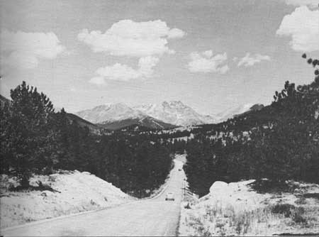 NEARING BEAVER MEADOWS, THOMPSON RIVER APPROACH TO TRAIL RIDGE ROAD. —A. R. Leding photo. |
AUTOMOBILE TRIPS
Mountain driving is different. In the park a speed limit of 35 miles per hour is enforced (20 m. p. h. on curves). This permits leisurely driving for sightseeing; however, you should not stop on the road. Park in a parking area and walk back to a scenic point, if necessary. Vapor lock, which often stalls cars, is caused, in part, by forcing the motor up grades in high gear; use lower gears and keep the motor cooler. Most cars stalled by vapor lock will start after cooling off for about 10 minutes. Keep your car in gear and use lower gears, if possible, on down grades, too; do not use overdrive. Drive carefully and courteously and enjoy the trip. The gateway towns have all the usual auto services.
Trail Ridge Road.—The 50-mile drive from Estes Park to Grand Lake across the Front Range in Rocky Mountain National Park is one of America's most magnificent auto trips. Trail Ridge Road above Hidden Valley is closed during the winter, but is usually open to through travel from early June until mid-October. A modern, hard-surfaced highway, it presents no unusual problems to the driver. For sheer scenic beauty, for easy access to the fantasies of timberline, the interesting tundra, and for variety of natural landscapes within a few miles, Trail Ridge Road has few equals anywhere in the world.
Trail Ridge proper is a massive ridge extending easterly from the Continental Divide. In the early days an Indian trail crossed the mountains via this ridge—hence the name. The present highway was built by the National Park Service during the early 1930's. The route was chosen to provide maximum scenic possibilities and minimum snow-clearance problems.
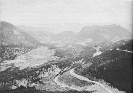 FROM RAINBOW CURVE, AN EXTENSIVE VIEW TO THE EAST AFFORDS GLIMPSES OF THE LOWER LEVELS OF TRAIL RIDGE ROAD. |
The lofty peaks of the Colorado Rockies have been sculptured by glaciers into a bewildering network of rocky ridges, sheer cliffs, needle like crags, and great cirques. Until roads were built, much of this breathtaking scenery was accessible only to the hardy mountain climber. Now, almost everyone can see, choice samples of the high country from their car windows.
Two approaches are available to Trail Ridge from the east. One—marked U. S. 34—passes through the Horseshoe Park and by Sheep Lake to Deer Ridge junction where it joins the other approach road, which leaves Estes Park as State Route 262 along the Thompson River and traverses Moraine Park and Beaver Meadows before it reaches Deer Ridge. From this point the route is one road—U. S. 34 on most road maps—to Grand Lake.
Although every mile of this road affords the motorist rare beauty and scenic appeal, there are several interesting points which deserve special attention. Many Parks Curve permits close observation of the chipmunk, Say's ground squirrel, and Clark's nutcracker. The views of the many parks, or meadows, from this vantage point are excellent. To the north is Fall River Valley, with the peaks of the Mummy Range towering beyond. This valley was the melting basin of a great glacier. A fine view is to be had toward the south as well. Here, Longs Peak (altitude 14,255 feet) towers far beyond the green flats of Beaver Meadows and Moraine Park. Several moraines—long, generally parallel ridges of broken rocks built up at the edges of glaciers and now heavily forested—stretch out before you, separating one park from the other.
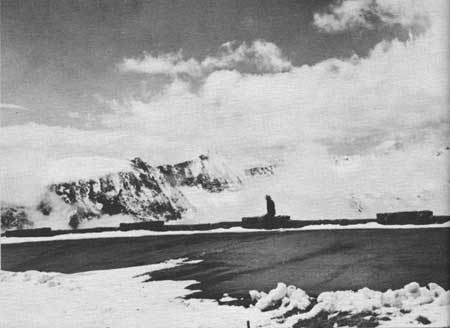 TRAIL RIDGE ROAD, ALTITUDE OVER 12,000 FEET, EXPERIENCES WINTER MOST OF THE YEAR. IT IS OPEN TO MOTOR TRAVEL DURING SUMMER ONLY. |
Above Many Parks Curve, the highway climbs along the north side of Trail Ridge, loops about the head of upper Hidden Valley (where skiing is in vogue during the winter), passes the 2-mile elevation sign, and reaches another parking area at Rainbow Curve, about 8 miles from Deer Ridge, and one-half mile higher in altitude. The view from Rainbow Curve is vast, open, and superb, with the Great Plains visible far to the east and forested canyons or glacial meadows nearer at hand. Many interesting geological features are pointed out on the roadside exhibit panels at this point.
Leaving Rainbow Curve, the road follows the rim of another deep canyon, passing through a ghost forest, scene of a devastating fire in the 1870's. Grotesquely formed timberline trees indicate the harsh climate at this high altitude. As the Rock Cabins are passed, a superlative view opens up to the south across Forest Canyon. For several miles the road traverses the tundra of the Alpine Zone which is carpeted during July by low-growing, colorful flowers.
At Rock Cut (altitude 12,110 feet) the glaciated mountains to the south appear to best advantage. The Gorge Lakes, Forest Canyon, and other landscape features are indicated in the roadside exhibits. If time permits, a short hike can be made over a nature trail to the nearby Roger W. Toll Memorial Peakfinder. A walk along this trail provides a rare opportunity to become acquainted with the tundra; however, the high altitude affects some people adversely, so it may not be advisable for persons with heart ailments to attempt the trip.
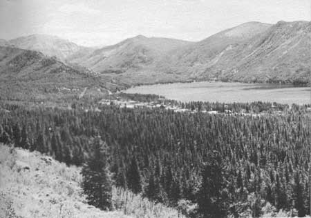 ALTHOUGH GRAND LAKE IS OUTSIDE THE PARK, THIS VIEW IS FROM THE LODGE, WITHIN THE PARK, A HALF-MILE OFF TRAIL RIDGE ROAD. |
Iceberg Lake, which occupies a glacial cirque, was named from the presence of blocks of ice on its surface even in late summer, except in extremely warm and dry years. The reddish cliffs at this point are made up of relatively recent lava, which is not common in the park. The highest point (altitude 12,183 feet) is indicated by a sign, between Iceberg Lake and Fall River Pass. The pass is a popular stopping place, where there are restrooms, an alpine exhibit room, and a lunch counter.
Below Fall River Pass the road continues downhill all the Way to Grand Lake. The Continental Divide is crossed at Milner Pass at an altitude of 10,759 feet, in the midst of a typical spruce-fir forest. As Far View Curve is approached, the valley of the Colorado River comes into view, and the rugged Never Summer Range looms up to the west. The road descends from this point in sharp switchback curves to reach the wide floor of the Colorado Valley. From here to Grand Lake, the route follows the valley. Deer and elk are often seen in this vicinity. Grand Lake can be seen to good advantage from the heights at Grand Lake Lodge, one-half mile off the Trail Ridge Road. The lake itself, over 250 feet deep, is one of Colorado's scenic gems. The town of Grand Lake, outside the park, is a friendly western town with the usual resort accommodations.
Bear Lake Road.—This is a short spur road, leading from State Route 262—on one of the eastern approaches to Trail Ridge—to Bear Lake, nestled at the foot of the high mountains. Everyone should make this trip, if time permits—an extra hour or so will do it. The road traverses glaciated meadows and moraines; it affords splendid views of Longs Peak. The great stands of aspen on Bierstadt Ridge make this a colorful drive in the autumn. Bear Lake, the end of the road, is the only high lake in the park accessible by auto. The lake is a foreground for the view up Tyndall Gorge, with the sheer cliff of Hallett's Peak making a dramatic backdrop to this alpine scene. A half-mile trail encircles the lake, giving different scenic effects with every step, and nature-trail labels aid in enjoyment of the rocks, flowers, and trees. A short hike—a mile or so—can be taken from Bear Lake to Dream Lake. This gives you a good opportunity to see some of the park and to escape auto traffic, without undertaking too arduous a climb.
Old Fall River Road.—This is the original road-crossing of the mountains and is rough, narrow, and steep. It is restricted to one-way up travel above Chasm Falls. Normally dangerous but passable, it is not recommended for any but experienced mountain drivers. It is wise to ask the rangers about this road, as it is sometimes temporarily closed by rock slides. The road takes you through beautiful mountain scenery, however, and permits an excellent circle drive from Estes Park, since it joins the modern highway at Fall River Pass, permitting return via Trail Ridge Road.

|

|

| NPS History | History & Culture | National Park Service | Contact |
|
Last Modified: Sat, Nov 4 2006 10:00:00 pm PST |