

|
ROCKY MOUNTAIN National Park |
 |
The Mountains Are Made
The geological story of Rocky Mountain National Park is a long one. Most of its details are lost in the passage of hundreds of millions of years of geologic time. Some of the story has been put together by scientists from bits of evidence scattered here and there. Like a detective story, the evidence strongly indicates a certain chain of events, but, unlike most such stories, no eyewitnesses are available to confirm the deductions. Few of these events can be proved to everyone's satisfaction; we can but pass on to you some determinations which geologists have made.
Most of the rocks which you see in the park are crystalline and very ancient. The gneiss and schist were, in part, once sediments formed in seas, perhaps a billion years ago, under conditions about which there is little knowledge or general agreement. These sediments were buried beneath thousands of feet of other sediments and were later squeezed, crushed, and elevated by slow, ceaselessly working earth forces which produced mountains even in that ancient time. During this period the sediments were changed to hard rocks, probably due to deep burial under tremendous pressure and considerable heat. Masses of molten rock welled up into these earlier deposits and hardened under the earth's surface. This later (although still very ancient) intrusive material is now exposed as granite in many parts of Rocky Mountain National Park.
These ancient mountains were gradually worn away by wind, rain, and the other agents of erosion which must have attacked the surface of the earth as vigorously then as now. With the passage of millions of years, these mountains were reduced to a lowland. Another sea gradually lapped over the land where mountains had been, and once again sediments were dropped in its bottom. This new invasion of the ocean affected the park region during many millions of years in which the dinosaurs dominated the earth.
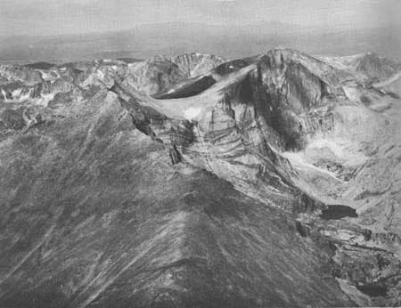 ROCKS ONCE BURIED MILES DEEP ARE NOW EXPOSED ON LONGS PEAK, AT AN ALTITUDE OF OVER 14,000 FEET. |
In response to little understood rhythms of the earth's crust, which have lifted mountains ever so slowly at great intervals all over the world, the seas drained away as the crust rose again, and the rising land once more became subject to the ceaseless attack of erosion. This uplift—which began about 60 million years ago—established the present system of mountain ranges and basins which gives Colorado its spectacular scenery and much of its climate. This great period of mountain-making is called the Laramide Revolution, from its early recognition in the Laramie Basin region of Wyoming.
The Front Range, of which this park preserves a choice sample, was buckled in the fashion of a great long wrinkle in a carpet. This "roll" of rock was about 200 miles long and some 40 miles across. In its earlier stages it was covered by the arched-up sediments, but, as time passed and erosion continued, the inner core of earlier crystalline rocks was exposed once again. Today, all traces of the former thick mantle of sedimentary beds are gone from the park. They are still present beneath the plains to the east and the basins to the west, and the cutoff ends of some of them now lie exposed in a tilted position against both east and west flanks of the mountains. The sandstones of some of the hogback ridges crossed by the approach roads from Lyons and Loveland are a part of this once continuous overburden.
Uplift continued intermittently during many million years. In the western section of the park volcanic eruptions took place. Specimen Mountain is the remnant of a volcano, flows from which make up the cliffs behind Iceberg Lake on Trail Ridge Road. Great sheets of lava and similar rocks piled up in layers now make up much of the colorful Never Summer Range. Eventually, these rocks, too, will be stripped away by the relentless work of erosion; however, this will require millions of years.
An unusual feature of the landscape here is the flat summit of many of its mountains. Trail Ridge Road crosses several miles of plainlike top of the range. These rolling summits appear to be all that is left of an old land surface which once may have been continuous far eastward over the area occupied today by the Great Plains. Such surfaces, of which the mountains in the park show many good samples, are called peneplains. Their presence atop the mountains is a part of the evidence suggesting that the range had been worn down by erosion to a fairly flat upland a few million years ago. Then renewed uplifting occurred, and streams draining the highland gradually cut canyons two or three thousand feet into the elevated surface.

|

|

| NPS History | History & Culture | National Park Service | Contact |
|
Last Modified: Sat, Nov 4 2006 10:00:00 pm PST |